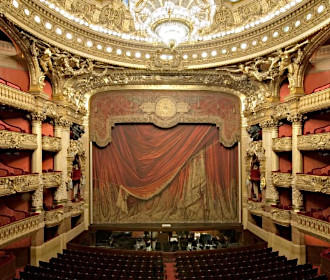
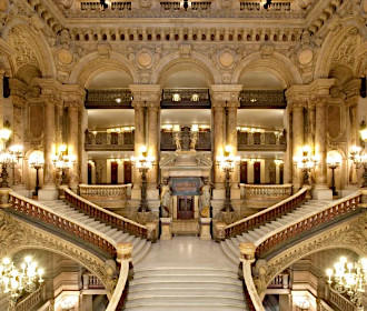
How to get to Palais Garnier Opera House in Paris using public transport
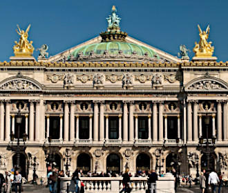
The beautiful and historical Palais Garnier Opera House hosts numerous performances each year, yet this is also a popular Paris tourist attraction with self-guided visits and guided tours available, not forgetting its museum. So below you can discover how to get to Palais Garnier with Paris public transport, including street maps, timetables, plans and more, which can all be downloaded by PDF or image formats to your PC or mobile device.
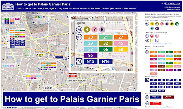
Palais Garnier transport map of Metro lines, trains and bus lines with stops, connections and street plan
Here you can see a street plan showing the location of the Palais Garnier Opera House and the Paris public transport situated around the area including Metro, trains and buses, which are all within a walking distance of approximately 1300 metres or less, in addition to a close up view of the streets around this famous entertainment venue in Paris showing the position of the closest bus stops and Metro station including its entrances.
How to get to Palais Garnier public transport maps available:
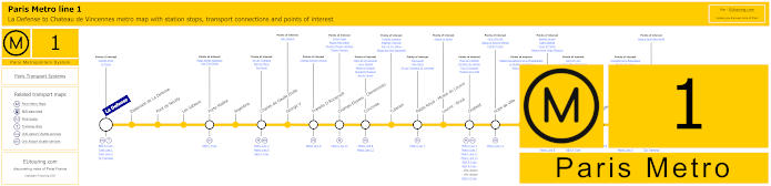
Paris Metro Line 1 map with stations, connections and points of interest
These maps show Paris Metro line 1, which travels from La Defense for getting to the Grande Arche and going through central Paris stopping at stations like Concorde, which is the stop you would need to reach Palais Garnier, the metro line travels on the Chateau de Vincennes Medieval castle.
Metro Line 1 stops:
La Defense, Esplanade de La Defense, Pont de Neuilly, Les Sablons, Porte Maillot, Argentine, Charles de Gaulle Etoile, George V, Franklin D Roosevelt, Champs-Elysees - Clemenceau, Concorde, Tuileries, Palais Royal - Musee du Louvre, Louvre - Rivoli, Chatelet, Hotel de Ville, Saint-Paul, Bastille, Gare de Lyon, Reuilly - Diderot, Nation, Porte de Vincennes, Saint-Mande, Berault, Chateau de Vincennes.
Metro line 1 main transport connections:
Metro Lines: 2, 4, 5, 6, 7, 8, 9, 11, 12, 13, 14. Train Lines: A, B, C, D, L, R, U. Tram Lines: T2, T3a, T3b.
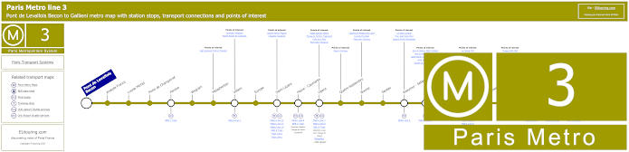
Paris Metro Line 3 map with stations, connections and points of interest
You will find that Metro line 3 is one of the closest options for getting to Palais Garnier Opera House as it has a stop called Opera, and as you can see from the metro maps this travels between Pont de Levallois Becon and Gallieni, which has numerous connections on route for Paris public transport including Gare Saint Lazare and Republique.
Metro Line 3 stops:
Pont de Levallois Becon, Anatole France, Louise Michel, Porte de Champerret, Pereire, Wagram, Malasherbes, Villiers, Europe, Saint-Lazare, Havre - Caumartin, Opera, Quatre-Septembre, Bourse, Sentier, Reaumur - Sebastopol, Arts et Metiers, Temple, Republique, Parmentier, Rue Saint-Maur, Pere Lachaise, Gambetta, Porte de Bagnolet, Gallieni.
Metro line 3 main transport connections:
Metro Lines: 2, 3b, 4, 5, 7, 8, 9, 11, 12, 13, 14. Train Lines, A, C, E , J, L. Tram Line: T3b. Bus Line: RoissyBus.
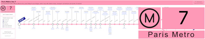
Paris Metro Line 7 map with stations, connections and points of interest
This shows the Paris Metro maps for line 7 travelling from La Courneuve 8 Mai 1945, then it splits at the stop Maison Blanche going to either Mairie d'Ivry or Villejuif Louis Aragon, and as you can see, like above, on rout there is a Metro station called Opera for Palais Garnier, plus it stops close to other popular Paris tourist attractions like Palais Royal - Musee du Louvre and Chatelet for getting to the Duc des Lombards Jazz Club.
Metro line 7 stops:
La Courneuve - 8 Mai 1945, Fort d'Aubervilliers, Aubervilliers - Pantin - Quatre Chemins, Porte de la Villette, Corentin Cariou, Crimee, Riquet, Stalingrad, Louis Blanc, Chateau-Landon, Gare de l'Est, Poissonniere, Cadet, Le Peletier, Chaussee d'Antin - La Fayette, Opera, Pyramides, Palais Royal - Musee du Louvre, Pont Neuf, Chatelet, Pont Marie, Sully - Morland, Jussieu, Place Monge, Censier - Daubenton, Les Gobelins, Place d'Italie, Tolbiac, Maison Blanche, Porte d'Italie, Porte de Choisy, Porte d'Ivry, Pierre et Marie Curie, Mairie d'Ivry, Le Kremlin-Bicetre, Villejuif - Leo Lagrange, Villejuif - Paul Vaillant-Couturier, Villejuif - Louis Aragon.
Metro line 7 main transport connections:
Metro Lines: 1, 2, 3, 4, 5, 6, 7bis, 8, 9, 10, 11, 14. Train Lines: A, B, D, E, P. Tram Lines: T1, T3a, T3b, T7. Bus Line: RoissyBus.
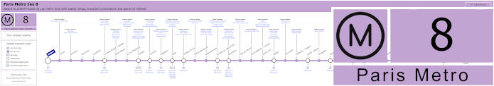
Paris Metro Line 8 map with stations, connections and points of interest
Again the Paris Metro line 8 has a stop at Opera for the beautiful Palais Garnier Opera House, and travelling from Balard to Creteil - Pointe du Lac, this has numerous Metro stations on route including for getting to Bastille Square and Opera Bastille, which is the newer opera house in Paris.
Metro line 8 stops:
Balard, Lourmel, Boucicaut, Felix Faure, Commerce, La Motte-Picquet - Grenelle, Ecole Militaire, La Tour-Maubourg, Invalides, Concorde, Madeleine, Opera, Richelieu-Drouot, Grands Boulevards, Bonne Nouvelle, Strasbourg - Saint-Denis, Republique, Filles du Calvaire, Saint-Sebastien - Froissart, Chemin Vert, Bastille, Ledru-Rollin, Faidherbe - Chaligny, Reuilly - Diderot, Montgallet, Daumesnil, Michel Bizot, Porte Doree, Porte de Charenton, Liberte, Charenton - Ecoles, Ecole Veterinaire de Maisons-Alfort, Maisons-Alfort - Stade, Maisons-Alfort - Les Juilliottes, Creteil - L'Echat, Creteil - Universite, Creteil - Prefecture, Creteil - Pointe du Lac.
Metro line 8 main transport connections:
Metro Lines: 1, 3, 4, 5, 6, 7, 9, 10, 11, 12, 13, 14. Train Lines: A, C. Tram Lines: T2, T3a. Bus Lines: RoissyBus, TVM (14).
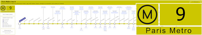
Paris Metro Line 9 map with stations, connections and points of interest
So here we have the Line 9 Paris Metro maps, which travels between Pont de Sevres and Mairie de Montreuil, and on route there is a stop called Porte de Saint-Cloud for getting to the Parc des Princes football stadium, another called Havre - Caumartin for getting to Palais Garnier and many others within walking distance of monuments and tourist attractions.
Metro line 9 stops:
Pont de Sevres, Billancourt, Marcel Sembat, Porte de Saint-Cloud, Exelmans, Michel-Ange - Molitor, Jasmin, Ranelagh, La Muette, Rue de la Pompe, Trocadero, Iena, Alma - Marceau, Franklin D Roosevelt, Saint-Philippe-du-Roule, Miromesnil, Saint-Augustin, Havre - Caumartin, Chaussee d'Antin - La Fayette, Richelieu - Drouot, Grands Boulevards, Bonne Nouvelle, Strasbourg - Saint-Denis, Republique, Oberkampf, Saint-Ambrose, Voltaire, Charonne, Rue des Boulets, Nation, Buzenval, Maraichers, Porte de Montreuil, Robespierre, Croix de Chavaux, Mairie de Montreuil.
Metro line 9 main transport connections:
Metro Lines: 1, 2, 3, 4, 5, 6, 7, 8, 10, 11, 13, 14. Train Lines: A, C, E. Tram Lines: T2, T3b. Bus Line: RoissyBus.
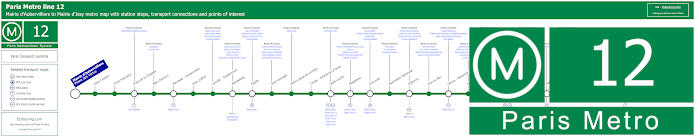
Paris Metro Line 12 map with stations, connections and points of interest
When it comes to Paris Metro line 12 and getting to Palais Garnier, you have the option of the Trinite - d'Estienne d'Orves stop or the Madeleine stop by Madeleine Church and Madeleine Square with its famous gourmet shops, with both Metro stops being only a short walk away from this entertainment venue that has a museum and visits available to this iconic building outside of performance hours and this Metro line travels between Mairie d'Aubervilliers and Mairie d'Issy.
Metro line 12 stops:
Mairie d'Aubervilliers (Plaine des Vertus), Aime Cesaire, Front Populaire, Porte de la Chapelle, Marx Dormoy, Marcadet - Poissonniers, Jules Joffrin, Lamark - Caulaincourt, Abessesses, Pigalle, Saint-Georges, Notre-Dame-de-Lorette, Trinite - d'Estienne d'Orves, Saint-Lazare, Madeleine, Concorde, Assemblee Nationale, Solferino, Rue du Bac, Sevres - Babylone, Rennes, Notre-Dame-des-Champs, Montparnasse - Bienvenue, Falguire, Pasteur, Volontaires, Vaugirard, Convention, Porte de Versailles, Corentin Celton, Mairie d'Issy.
Metro line 12 main transport connections:
Metro Lines 1, 2, 3, 4, 6, 8, 10, 13, 14. Train Lines: C, E, J, L, N, Funiculaire de Montmartre. Tram Lines: T2, T3a, T3b.
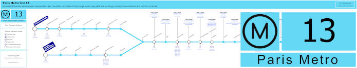
Paris Metro Line 13 map with stations, connections and points of interest
Travelling from Chatillon Montrouge, you will see from the Metro maps that the Paris Metro line splits at the La Fourche stop and goes to either St-Denis Universite or Asnieres Gennevilliers - Les Courtilles, and this is one of the options for getting to the Stade de France via the Saint-Denis - Porte de Paris stop, yet for Palais Garnier you would need the Gare Saint-Lazare train station.
Metro line 13 stops:
St-Denis Universite, Basilique de St-Denis, Saint-Denis - Porte de Paris, Carrefour Pleyel, Mairie de St-Ouen, Garibaldi, Porte de St-Ouen, Guy Moquet, Asnieres - Gennevilliers Les Courtilles, Les Agnettes, Gabriel Peri, Mairie de Clichy, Porte de Clichy, Brochant, La Fourche, Place de Clichy, Liege, Saint-Lazare, Miromesnil, Champs-Elysees - Clemenceau, Invalides, Varenne, Saint-Francois-Xavier, Duroc, Montparnasse - Bienvenue, Gaite, Pernety, Plaisance, Porte de Vanves, Malakoff - Plateau de Vanves, Malakoff - Rue Etienne Dolet, Chatillon Montrouge.
Metro line 13 main transport connections:
Metro Lines: 1, 2, 3, 4, 6, 8, 9, 10, 12, 14. Train Lines: C, E, J, L, N. Tram Lines: T1, T3a, T3b, T5, T6, T8.
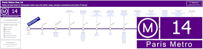
Paris Metro Line 14 map with stations, connections and points of interest
Classed as an automated Metro line, which is also disabled friendly, the Paris Metro line 14 travel between Olympiades and Saint-Lazare, which is either this latter terminus or the stop prior of Madeleine that you would need for getting to the Palais Garnier Opera House, and as you can see from the metro maps, this is also has a stop at Bercy for getting to Bercy Arena now called AccorHotels Arena and formerly the POPB.
Metro line 14 stops:
Mairie de Saint-Ouen (Region Ile-de-France), Saint-Ouen, Porte de Clichy (Tribunal de Paris), Pont Cardinet, Saint-Lazare, Madeleine, Pyramides, Chatelet, Gare de Lyon, Bercy, Cour Saint-Emilion, Bibliotheque Francois Mitterrand, Olympiades.
Metro line 14 main transport connections:
Metro Lines: 1, 3, 4, 6, 7, 8, 9, 11, 12, 13. Train Lines: A, B, C, D, E, J, L, R. Tram Lines: T3a Walk, T3b.
Some attractions close to Metro line 14 stops:
Square Marcel Pagnol, Chapelle Expiatoire, Cafe Marco Polo, Place de la Madeleine and Church, Fauchon, Hediard, La Maison de la Truffe, Fragonard Theatre Musee des Capucines, La Belle Epoque Cabaret, Palais Royal and Petit Canon, The Louvre, Tuileries Gardens, Musee des Arts Decoratifs , Place de Chatelet, Saint-Jacques Tower, Dans la Noir Restaurant, Fontaine des Innocents, River Seine, Le Train Bleu Restaurant, Cafe Barge, Les Docks, l'Improviste Jazz Club, Le Playtime, Le VIP Paris, Bercy Park, POPB Arena, Cinematheque Francaise and Museum, Dame de Canton, Nix Nox, Bercy Village, Yitzhak Rabin Garden, Fairground Museum, Bercy Pavilions, Chai 33 Restaurant, Le Batofar, Bibliotheque Francois Mitterand Forest Garden, Globes of Louis XIV Museum, Allee Arthur Rimbaud, Bateau El Alamein, Cyprian Norwid Garden.
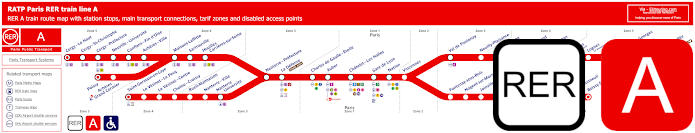
Red RER A train line map showing station stops, line branches, transport connections and zones
Here you can see the maps for the RER A train line that travels through Paris stopping at various stations including Auber close to Palais Garnier and Gare de Lyon train station, and this is one of the main options you have for getting to Disneyland Paris via the Marne-la-Vallee Chessy stop and terminus, but please note the various ticket tariff zones that RER A travels through such as Poissy in Zone 5.
Paris RER A train line stops:
Cergy le Haut*, Cergy Saint-Christophe, Cergy Prefecture, Neuville Universite, Conflans Fin d’Oise, Acheres Ville, Maisons-Laffitte, Sartrouville, Houilles - Carrieres sur Seine, Nanterre Prefecture, La Defense (Grande Arche), Charles de Gaulle Etoile, Auber, Chatelet Les Halles, Paris Gare de Lyon, Nation, Vincennes, Val de Fontenay, Neuilly Plaisance, Bry sur Marne, Noisy le Grand - Mont d’Est, Noisy Champs, Noisiel, Lognes, Torcy, Bussy Saint-Georges, Val d’Europe, Marne la Vallee - Chessy (Parcs Disneyland)*, Poissy*, Acheres - Grand Cormier, Saint-Germain en Laye*, Le Vesinet Le Pecq, Le Vesinet Centre, Chatou Croissy, Rueil Malmaison, Nanterre Ville, Nanterre University, Fontenay sous Bois, Nogent sur Marne, Joinville le Pont, Saint-Maur - Creteil, Le Parc de Saint-Maur, Champigny, La Varenne - Chennevieres, Sucy Bonneuil, Boissy Saint-Leger*.
* Terminus Points.
Paris RER A train line main transport connections:
Metro Lines: 1, 2, 3, 4, 6, 7, 8, 9, 11, 14. Train Lines: B, D, E, J, L, R, U, TGV. Tram Lines: T2, 13. Bus Lines: 393, RoissyBus, TVM (14).
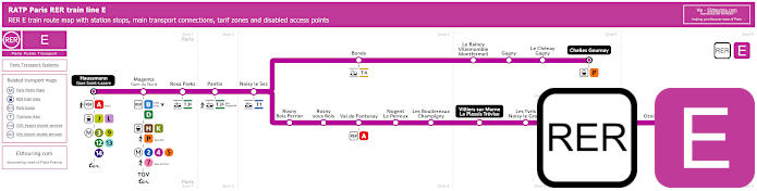
Pink RER E train line map showing station stops, line branches, transport connections and zones
Whereas this shows the maps for the RER line E that starts from Haussmann St-Lazare train station, which is located within a short walk of the Palais Garnier Opera House and from Paris the train route either goes to Chelles Gournay or branches off and goes to Tournan, with many stops on route including at Gare du Nord train station with its numerous transport connections including the Eurostar.
Paris RER E train line stops:
Haussmann St-Lazare*, Gare du Nord - Magenta, Rosa Parks, Pantin, Noisy le Sec, Bondy, Le Raincy - Villemomble - Montfermeil, Gagny, Le Chenay - Gagny, Chelles - Gournay*, Rosny - Bois Perrier, Rosny-sous-Bois, Val de Fontenay, Nogent - Le Perreux, Les Boullereaux - Champigny, Villiers sur Marne - Le Plessis Trevise, Les Yvris - Noisy le Grand, Emerainville - Pontault Combault, Roissy en Brie, Ozoir la Ferriere, Gretz - Armainvilliers, Tournan*.
* Terminus Points.
Paris RER E train line main transport connections:
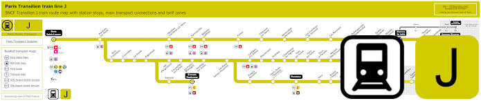
Transilien train line J map showing station stops, line branches, transport connections and zones
Yet these maps show the Transilien Line J which is a Paris train line starting from Gare Saint-Lazare within walking distance of Palais Garnier, and going through various communes or areas of the Paris region, Ile de France, there are various branches, main connection stations and terminus points like Ermont Eaubonne and Pontoise. Additionally you can find out the live departure and arrival times from the link below.
Paris train line J stops:
Paris Saint-Lazare*, Asnieres sur Seine, Bois Colombes, Colombes, Le Stade, Argenteuil, Sannois, Ermont Eaubonne*, Val d'Argentuil, Cormeilles en Parisis, La Frette Montigny, Herblay, Conflans Ste-Honorine, Eragny Neuville, St-Ouen l'Aumone (Quartier de l'Eglise), Pontoise**, Osny, Boissy l'Aillerie, Montgeroult - Courcelles, Us, Santeuil le Perchay, Chars, La Villetertre, Liancourt St-Pierre, Chaumont en Vexin, Trie Chateau, Gisors*, Houilles - Carrieres sur Seine, Sartroville, Maisons Lafitte, Poissy, Villennes sur Seine, Vernouillet - Verneuil, Les Clairieres de Verneuil, Les Mureaux, Aubergenville - Elisabethville, Epone Mezieres, Mantes Station, Mantes la Jolie**, Breval, Evreux*, Conflans Fin d'Oise, Maurecourt, Andresy, Chanteloup les Vignes, Triel sur Seine, Vaux sur Seine, Thun le Paradis, Meulan - Hardricourt, Juziers, Gargenville, Issou - Porcheville, Limay, Rosy sur Seine, Bonnieres, Vernon*.
* Terminus Points. ** Train J Transfer Points.
Paris train line J main transport connections:
Metro Lines: 3, 9, 12, 13, 14. Train Lines: A, C, E, H, L, N, TER.
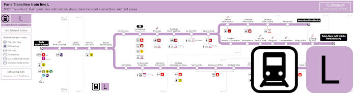
Transilien train line L map showing station stops, line branches, transport connections and zones
Although here we have the Translien Line L, also run by SNCF, and as you can see from these Paris train maps, starting from Paris Saint-Lazare close to the Palais Garnier Opera House, this is one of the options for getting to Chateau de Versailles, which is the famous former royal castle, along with many other tourist attractions in the Paris region, yet please ensure you take the correct branch of the line for your destination like Versailles Rive Droite.
Paris train line L stops:
Paris Saint-Lazare*, Pont Cardinet, Clichy Levallois, Asnieres sur Seine, Becon les Bruyeres, Courbevoie, La Defense (Grande Arche), Puteaux, Suresnes - Mont Valerien, Le Val d'Or, St-Cloud, Sevres - Ville d'Avray, Chaville Rive Droite, Viroflay Rive Droite, Montreuil, Versailles Rive Droite*, Garches - Marnes la Coquette, Vaucresson, La Celle St-Cloud, Bougival, Louveciennes, Marly le Roi, L'Etang la Ville, St-Nom la Breteche - Foret de Marly**, Noisy le Roi*, Mareil Marly, St-Germain en Laye - Bel Air Fourqueux, St-Germain en Laye G.C.*, Les Vallees, La Garenne Colombes, Nanterre Universite, Houilles - Carrieres sur Seine, Sartrouville, Maisons Lafitte, Acheres Ville, Conflans - Fin d'Oise, Neuville Universite, Cergy - Prefecture, Cergy - St-Christophe, Cergy le Haut*.
* Terminus Points. ** Train L Transfer Point.
Paris train line L main transport connections:
Metro Lines: 1, 3, 9, 12, 13, 14. Trian Lines: A, E, J, U, TER. Tram Lines: T2, T6, T13.
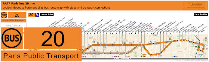
RATP Paris bus line 20 with stops, connections and street plan
The majority of Paris buses are run by RATP and here you have the bus line 20 that travels from Louison Bobet to Porte des Lilas, and as you can see from the bus maps and timetables, there is a stop called Opera, which is one of the closest bus stops you can get for Palais Garnier, yet please take note that numerous stops are only served in a particular direction.
Paris bus line 20 stops:
Louison Bobet, Alsace**, Curnonsky*, Reims - Hotel des Impots*, Porte d’Asnieres - Marguerite Long, Juliette Lamber, Wagram - Pereire, Jouffroy d’Abbans - Malesherbes, Place du General Catroux, Malesherbes - Courcelles, Lisbonne - Mairie du 8e, Saint-Augustin, Gare Saint-Lazare*, Pasquier - Anjou*, Havre - Haussmann, Auber, Opera, Opera - Quatre Septembre**, Choiseul*, Richelie - Drouot*, Richelieu - Quatre Septembre**, Bourse**, Grands Boulevards*, Reaumur - Montmartre**, Poissonniere - Bonne Nouvelle*, Sentier**, Porte Saint-Denis*, Reaumur - Sebastopol**, Reaumur - Arts et Metiers**, Porte Saint-Martin*, Arts et Metiers**, Square du Temple**, Lancry - Saint-Martin*, Turbigo - Republique**, Republique - Magenta**, Republique, Ferry - Lenoir**, Jules Ferry*, Parmentier - Republique**, Goncourt*, Saint-Maur - Jean Aicard**, Belleville - Menilmontant**, Couronnes**, Faubourg du Temple - Piver*, Ramponeau**, Belleville, Julien Lacroix, Pyrenees - Belleville, Jourdain, Rue des Fetes, Pixerecourt, Pelleport - Belleville, Haxo, Porte des Lilas Metro, Porte des Lilas.
* Served in direction of Louison Bobet. ** Served in direction of Porte des Lilas.
Paris bus line 20 main transport connections:
Metro Lines: 2, 3, 3bis, 4, 5, 7, 8, 9, 11, 12, 13, 14. Train Lines: A, E, J, L. Tram Line: T3b.
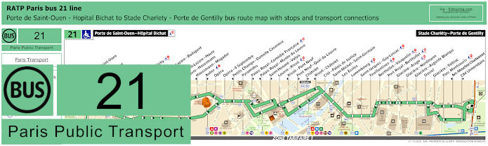
RATP Paris bus line 21 with stops, connections and street plan
Whereas this shows the maps and timetables for RATP Paris bus line 21 travelling between Porte de Saint-Ouen - Hopital Bichat and Stade Charlety - Porte de Gentilly, which again stops at Opera for the impressive Palais Garnier Opera House, yet this also provides an option for getting to many other famous tourist attractions and Paris monuments.
Paris bus line 21 stops:
Porte de Saint-Ouen - Hopital Bichat, Porte de Saint-Ouen, Navier, Guy Moquet, Davy, La Fourche, Ganneron, Place de Clichy, Liege, Gare Saint-Lazare - Budapest**, Trinite*, Gare Saint-Lazare - Havre**, Havre - Haussmann**, Haussmann - Mogador*, Auber**, Opera, Opera - 4 Septembre, Petits Champs - Danielle Casanova*, Pyramides, Palais Royal - Comedie Francaise**, Palais Royal - Musee du Louvre*, Saint-Honore - Valois**, Louvre - Rivoli, Rivoli - Pont Neuf*, Pont Neuf - Quai du Louvre**, Chatelet**, Rivoli - Chatelet*, Cite - Palais de Justice, Saint-Michel - Saint-Germain, Les Ecoles, Luxembourg, Saint-Jacques - Gay-Lussac, Feuillantines, Berthollet - Vauquelin, Port Royal - Berthollet, Glaciere - Arago, Glaciere - Nordmann, Glaciere - Auguste Blanqui, Daviel, Glaciere - Tolbiac, Parc Montsouris, Am. Mouchez Charbonnel*, Cite Universitaire**, Stade Charlety - Porte de Gentilly.
* Stop served in direction of Porte de Saint-Ouen - Hopital Bichat. ** Stop served in direction of Stade Charlety - Porte de Gentilly.
Paris bus line 21 main transport connections:
Metro Lines: 1, 2, 3, 4, 6, 7, 8, 9, 10, 11, 12, 13, 14. Train Lines: A, B, D, E, J, L. Tram Lines: T3a, T3b.
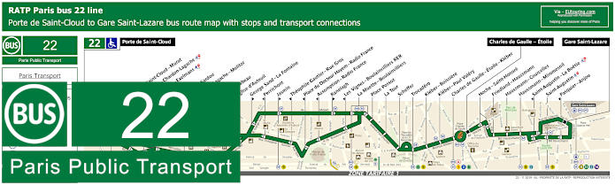
RATP Paris bus line 22 with stops, connections and street plan
The Paris bus line 22 goes from POrte de Saint-Cloud to Gare Saint-Lazare train station, which is the nearest point to Palais Garnier on this bus route, yet as you can see from the maps and timetables there is a secondary main stop of Charles de Gaulle - Etoile, which is how to get to the Arc de Triomphe and also see the Tomb of the Unknown Soldier with the eternal flame.
Paris bus line 22 stops:
Porte de Saint-Cloud, Porte de Saint-Cloud - Murat, Versailles - Chardon-Lagache, Versailles - Exelmans**, Jouvenet*, Victorien Sardou**, Chardon-Lagache - Molitor*, Wilhem**, Pont Mirabeau**, Eglise d’Auteuil, George Sand - La Fontaine**, Perrichont*, Jasmin**, Theophile Gautier - Rue Gros*, Place du Docteur Hayem - Radio France*, Assomption - Radio France*, Ranelagh**, Les Vignes - Boulainvilliers RER*, La Muette - Boulainvilliers, Place Possoz, La Tour, Scheffer, Trocadero, Kleber - Boissiere, Kleber - Paul Valery, Charles de Gaulle - Etoile - Kleber, Charles de Gaulle - Etoile, Hoche - Saint-Honore, Friedland - Haussmann, Haussmann - Courcelles, Haussmann - Miromesnil, Saint-Augustin - La Boetie*, Saint-Augustin, Pasquier - Anjou*, Gare Saint-Lazare.
* Stop served in direction of Porte de Saint-Cloud. ** Stop served in direction of Gare Saint-Lazare.
Paris bus line 22 main transport connections:
Metro Lines: 1, 2, 3, 6, 9, 10, 12, 13, 14. Train Lines: A, C, E, J, L.
RATP Paris bus line 26 with stops, connections and street plan
Again the nearest stop to Palais Garnier on the Paris bus line 26 is the Gare Saint-Lazare stop and terminus point, with the opposite terminus being Nation - Trone, yet as you can see from the bus maps and timetables you could also utilise the Trinite bus stop, which will also get you within walking distance of one of the museums in Paris called Musee Gustave Moreau.
Paris bus line 26 stops:
Gare Saint-Lazare, Gare Saint-Lazare - Budapest*, Trinite, St-Georges - Chateaudun, Carrefour de Chateaudun, Chateaudun - Lamartine*, Cadet*, Maubeuge - Rochechouart*, Square Montholon*, Condorcet*, Place Franz Liszt*, Magenta - Maubeuge*, La Fayette - St-Quentin - Gare du Nord*, Gare du Nord - Dunkerque*, La Fayette - Dunkerque, Chateau Landon, Louis Blanc*, Jaures - Stalingrad*, Marche Secretan, Mathurin Moreau - S. Bolivar, Atlas, Botzaris - Buttes Chaumont, Pyrenees - Belleville, Jourdain, L'Ermitage, Pyrenees - Menilmontant, Villiers de l'Isle Adam, Gambetta - Pyrenees, Ramus, Pyrenees - Bagnolet, Orteaux, Maraichers, La Plaine, Cours de Vincennes, Marsoulan, Nation - Trone.
* Stop only served in a particular direction.
Paris bus line 26 main transport connections:
Metro Lines: 1, 2, 3, 3bis, 4, 5, 6, 7, 7bis, 9, 11, 12, 13, 14. Train Lines: A, B, D, E, H, J, K, L, P. Tram Lines: T3a, T3b.
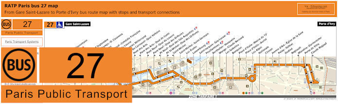
RATP Paris bus line 27 with stops, connections and street plan
Also travelling from Gare Saint-Lazare but through to Porte d'Ivry, you will find that the bus line 27 has a stop called Opera, virtually outside the Palais Garnier Opera House, and as you can see from the street maps and their timetables, this is one of the options for visiting other attractions like getting to Luxembourg Gardens for instance.
Paris bus line 27 stops:
Gare Saint-Lazare, Havre - Haussmann, Auber, Opera, Opera - 4 Septembre, Petits Champs - D. Casanova*, Pyramides, Palais-Royal - Comedie Francaise, Musee du Louvre*, Quai Francois Mitterrand**, Pont du Carrousel - Quai Voltaire*, Pont des Arts**, Pont des Arts - Quai de Conti*, Pont Neuf - Quai du Louvre**, Pont Neuf - Quai des Orfevres**, Pt Neuf - Quai des Gds Augustins*, Pt St-Michel - Quai des Orfevres**, Saint-Michel*, Saint-Michel - Saint-Germain, Les Ecoles, Luxembourg, Saint-Jacques - Gay-Lussac, Feuillantines, Berthollet - Vauquelin, Monge - Claude Bernard, Les Gobelins, Banquier, Place d’Italie - Mairie du 13e, Place d’Italie - Auriol, Les Alpes, Nationale, Clisson, Jeanne d’Arc - Eglise de la Gare, Patay - Tolbiac, Oudine, Regnault, Massena - Darmesteter*, Porte de Vitry, Claude Regaud**, Porte d'Ivry.
* Stop served in direction of Gare Saint-Lazare. ** Stop served in direction of Porte d'Ivry.
Paris bus line 27 main transport connections:
Metro Lines: 1, 3, 4, 5, 6, 7, 8, 9, 12, 13, 14. Train Lines: A, B, C, E, L, J. Tram Line: T3a.
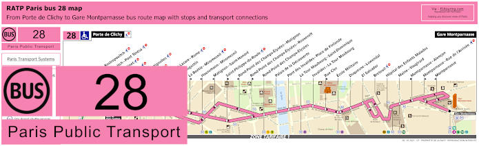
RATP Paris bus 28 map with stops, connections and street plan
Yet here you have the bus maps and timetables for the RATP bus line 28 travelling from Porte de Clichy to the Gare Montparnasse train station, which is located by the Tour Montparnasse with its panoramic viewing platform and restaurant that is one of the highest in Europe. and with numerous other bus stops by tourist attractions on route for the Palais Garnier you would need Paris Saint-Lazare as above.
Paris bus line 28 stops:
Porte de Clichy, Berthier - Rostropovitch, Rostropovitch - Pont Teresa, Pont Cardinet, Legendre, Rome - Batignolles, Europe, Gare Saint-Lazare, Saint-Augustin, La Boetie - Miromesnil, Haussmann - Miromesnil, Matignon - Saint-Honore, Saint-Philippe-du-Roule, Rond-Point des Champs-Elysees - Matignon, Rond-Point des Champs-Elysees - Roosevelt, Rond-Point des Champs-Elysees, Palais de la Decouverte, Pont des Invalides - Place de Finlande, La Tour Maubourg - Saint-Dominique, Invalides - La Tour Maubourg, Rue Cler, Ecole Militaire, Duquesne-Lowendal, El Salvador, Breteuil, Hopital des Enfants Malades, Maine - Vaugirard, Montparnasse - Alencon, Montparnasse - Rue de l’Arrivee, Montparnasse, Gare Montparnasse.
Paris bus line 28 main transport connections:
Metro Lines: 1, 2, 3, 4, 6, 8, 9, 10, 12, 13, 14. Train Lines: C, E, J, L, N. Tram Line: T3b.
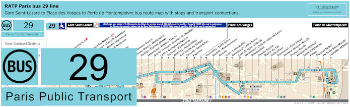
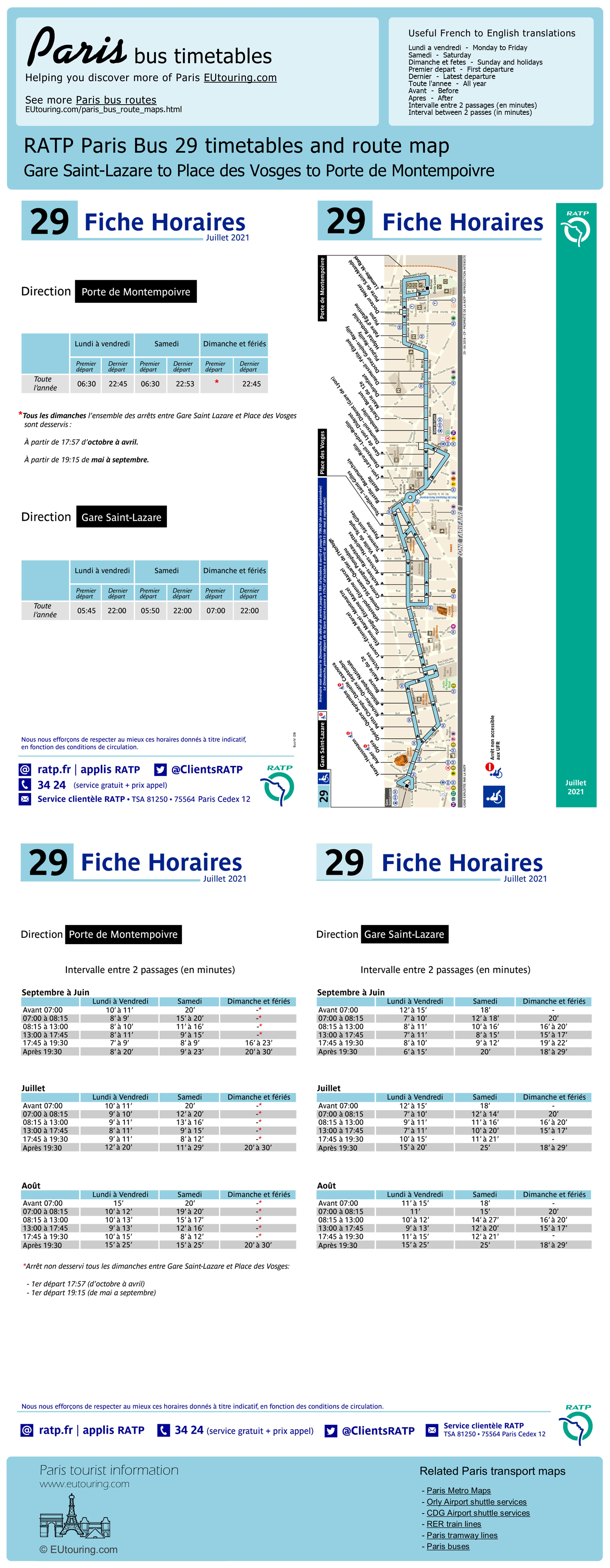
RATP Paris bus 29 map with stops, connections and street plan
This shows the Paris bus line 29 travelling from Porte de Montempolvre, and as you can see from the RATP bus maps and timetables, it normally goes through to Gare Saint-Lazare, and has various stops around the Palais Garnier including the Opera stop being the closest along with others including Havre - Haussmann, Auber and Opera - Quatre Septembre, yet we would like to point out that on a Sunday until the evening the service only goes to Place des Vosges, and therefore is not suitable for visiting this entertainment venue on a Sunday daytime.
Paris bus line 29 stops:
Gare Saint-Lazare, Havre - Haussmann, Auber, Opera, Opera - Quatre Septembre, Petits Champs - Danielle Casanova**, Richelieu - Quatre Septembre*, Bibliotheque Nationale**, Bourse*, Mairie du 2e*, Victoires, Louvre - Etienne Marcel**, Etienne Marcel - Montmartre, Turbigo - Etienne Marcel, Sebastopol - Etienne Marcel, Grenier St-Lazare - Quartier de l’Horloge, Centre Georges Pompidou*, Archives - Rambuteau*, Archives - Haudriettes**, Rue Vieille du Temple, Turenne - Saint-Gilles**, Payenne*, Place des Vosges*, Tournelles-Saint-Gilles**, Bastille - Beaumarchais, Bastille, Lyon - Ledru-Rollin*, Daumesnil - Ledru-Rollin**, Gare de Lyon - Diderot*, Daumesnil - Diderot (Gare de Lyon), Rambouillet, Charles Bossut, Mairie du 12e, Dubrunfaut, Daumesnil - Felix Eboue, Docteur Goujon - Reuilly, Picpus - Reuilly, Hopital Rothschild, Fabre d’Eglantine, Picpus, Docteur Netter, Porte de Saint-Mande, J. Lemaitre - M. Ravel*, Porte de Montempoivre.
* Served in direction of Porte de Montempoivre. ** Served in direction of Gare Saint-Lazare.
Paris bus line 29 main transport connections:
Metro Lines: 1, 3, 4, 5, 6, 7, 8, 9, 11, 12, 13, 14. Train Lines: A, D, E, J, L, R. Tram Line: T3a.
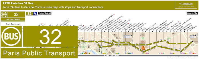
RATP Paris bus line 32 with stops, connections and street plan
The RATP Paris bus line 32 does have a stop at Opera for the Palais Garnier, although as you can see from the maps and timetables it is only served in the direction of the Gare de l'Est terminus, so if you are travelling in the opposite direction to the Porte d'Auteuil terminus, which is an option for getting to the Hippodrome de Longchamp horse racing course, then you would need the Chaussee d'Antin bus stop.
Paris bus line 32 stops:
Porte d'Auteuil, Gare d’Auteuil**, Alfred Capus, Raffet, Porte de Passy, Louis Boilly**, Avenue Ingres*, La Muette - Boulainvilliers, Passy - Boulainvilliers**, Place de Passy**, Place Possoz*, Jean Bologne**, La Tour*, Passy - La Tour**, Scheffer, Trocadero, Albert de Mun, Iena, Marceau - P. 1er de Serbie - Pl. de Beyrouth, Pierre Charron - Francois 1er, La Boetie - Champs-Elysees, Rd-Pt des Champs-Elysees - Matignon**, Saint-Philippe du Roule*, Matignon - Saint-Honore**, Haussmann - Miromesnil**, La Boetie - Miromesnil*, Saint-Augustin, Pasquier - Anjou*, Gare Saint-Lazare**, Rome - Haussmann*, Havre - Haussmann**, Havre - Caumartin*, Auber, Opera**, Chaussee d'Antin*, Choiseul**, Le Peletier - Haussmann*, Richelieu - Drouot**, Carrefour Chateaudun*, Cadet*, Square Montholon*, Grands Boulevards**, Poissonniere - Bonne Nouvelle**, Hauteville*, Porte Saint-Denis**, Chateau d’Eau**, Faubourg - Saint-Denis*, Gare de l'Est.
* Stop served in direction of Porte d'Auteuil. ** Stop served in direction of Gare de l'Est.
Paris bus line 32 main transport connections:
Metro Lines: 1, 3, 4, 5, 6, 7, 8, 9, 10, 12, 13, 14. Train Lines: C, E, J, L, P.
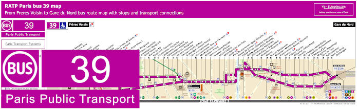
RATP Paris bus line 39 with stops, connections and street plan
Just like many other Paris buses, there are numerous stop only served in a particular direction, just like Richelieu - Drouot heading in the direction of Freres Voisin, so for getting to the Palais Garnier Opera House your best option when utilising this bus route is the the Richelieu - 4 Septembre stop that goes in both directions including to the opposite terminus of Gare du Nord, but this is also an option for getting to the Musee du Louvre and other popular landmarks in Paris.
Paris bus line 39 stops:
Freres Voisin, Maison de Retraite**, Colonel Pierre Avia*, Severine**, Louis Armand*, Suzanne Lenglen*, Porte d’Issy**, Balard*, Balard - Lecourbe*, Desnouettes**, Desnouettes - Vasco de Gama**, Lycee Louis Armand*, Hameau**, Duranton**, Hopital de Vaugirard**, Convention - Lecourbe*, Convention - Vaugirard**, Abbe Groult, Mairie du 15e*, Vaugirard - Favorites**, Cambronne - Lecourbe*, Cambronne - Vaugirard**, Volontaires - Lecourbe*, Volontaires - Vaugirard**, Sevres - Lecourbe*, Pasteur - Lycee Buffon, Armorique - Musee Postal, Gare Montparnasse, Montparnasse - Rue de l’Arrivee*, Montparnasse**, Rennes - Littre, Rennes - Saint-Placide, Rennes - d’Assas, Michel Debre, Saint-Germain des Pres, Jacob, Pont du Carrousel - Quai Voltaire, Musee du Louvre, Palais Royal - Comedie Francaise, Sainte-Anne - Petits Champs**, Bibliotheque Nationale*, Richelieu - 4 Septembre, Richelieu - Drouot*, Bourse**, Grands Boulevards*, Reaumur - Montmartre**, Poissonniere - Bonne Nouvelle*, Sentier**, Petites Ecuries*, Reaumur - Sebastopol**, Paradis*, Strasbourg - Saint-Denis**, La Fayette - Poissonniere*, Chateau d'Eau**, Magenta - Maubeuge*, Gare de l'Est**, Valenciennes**, Gare du Nord - Dunkerque*, Gare du Nord.
* Served in the direction of Freres Voisin ** Served in the direction of Gare du Nord
Paris bus line 39 main transport connections:
Metro lines: 1, 2, 3, 4, 5, 6, 7, 8, 9, 10, 12, 13. Train lines: B, D, E, H, K, N, P. Tram lines: T2, T3a.
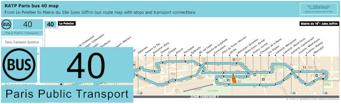
RATP Paris bus line 40 with stops, connections and route plan
The bus line 40 took over from the Montmartrobus and is the best bus route to take when you are looking at how to get to Sacre Coeur Basilica along with other attractions and entertainment venues in this famous area of Paris like the Moulin Rouge cabaret and Lapin Agile, yet getting back to the Palais Garnier, as you can see from the RATP bus 40 maps and timetables you could utilise the Carrefour de Chateaudun stop heading in the direction of Mairie du 18e - Jules Joffrin or the Saint-Georges - Chateaudun stop travelling in the direction of Le Peletier terminus.
Paris bus line 40 stops:
Le Peletier, Carrefour de Chateaudun, Saint-Georges - Chateaudun, Saint-Georges, Gustave Toudouze, Navarin, Rochechouart - Martyrs, Pigalle, Martyrs, Orsel, Abbesses, Yvonne Le Tac, Durantin - Burq, Tholoze, Chappe, Drevet, Tourlaque, Gabrielle, 88, rue Lepic, Moulin de la Galette, Funiculaire, Place du Tertre - Norvins, Utrillo, Abreuvoir - Girardon, Mont-Cenis - Cortot, Saules - Cortot, Chevalier de la Barre, Les Vignes, Lamarck - Becquerel, Lamarck - Mont-Cenis, Lamarck - Caulaincourt, Custine - Mont-Cenis, Custine - Ramey, Marcadet, Mairie du 18e - Jules Joffrin.
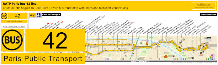
RATP Paris bus line 42 with stops, connections and street plan
Travelling from Gare Saint-Lazare as you can see from the bus 42 maps and timetables you also have the Havre - Haussmann bus stop even slightly nearer to the Palais Garnier, and this Paris bus line 42 has a route going through to Cours de l'Ile Seguin, which is within walking distance of getting to the La Seine Musicale, another very popular entertainment venue in Paris located on an island within the River Seine.
Paris bus line 42 stops:
Cours de l'Ile Seguin, Parch de Billancourt, Place Jules Guesde, Marche de Billancourt, Marcel Sembat - Metro, Rene Descartes, Henri Martin, Porte de Saint-Cloud, Porte de Saint-Cloud-Murat, Versailles - Chardon Lagache, Versailles Exelmans, Pont du Garigliano, Hopital Europeen - Georges Pompidou, Rue Leblanc (Entree Principale de l'Hop.), Leblanc - Delbarre**, Place Balard, Balard - Lecourbe*, Saint-Charles - Balard**, Lecourbe - Vasco de Gama*, Vasco de Gama - Lourmel*, Lourmel - Felix Faure*, Rond-Point Saint-Charles**, Convention - Saint-Charles**, Convention - Lourmel*, Charles Michels, Theatre, Rue Rouelle, Docteur Finlay**, Dupleix, Desaix, Champ de Mars - Suffren, Rapp - La Bourdonnais, Monttessuy, Tour Eiffel, Bosquet - Rapp, Alma - Marceau, Montaigne - Francois 1er, Rond-Point des Champs-Elysees, Champs-Elysees - Clemenceau, Concorde - Cours la Reine, Concorde*, Concorde - Royale**, Madeleine - Malesherbes*, Madeleine*, Havre - Haussmann, Gare Saint-Lazare - Havre*, Gare Saint-Lazare.
* Stop served in the direction of Cours de l'Ile Seguin. ** Stop served in the direction of Gare Saint-Lazare.
Paris bus line 42 main transport connections:
Metro Lines: 1, 3, 6, 8, 9, 10, 12, 13, 14. Train Lines: C, E, J, L. Tram Line: T3a.
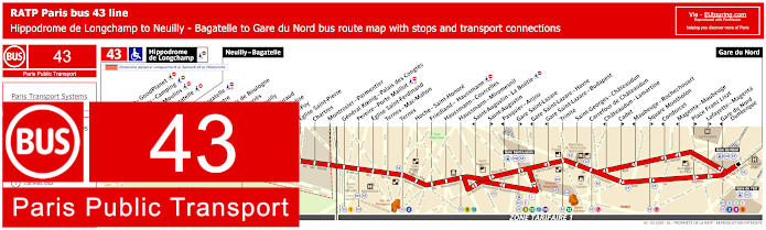
RATP Paris bus line 43 with stops, connections and street plan
Whereas this show the maps and timetables for bus line 43 that travels from Gare du Nord through to Neuilly - Bagatelle, yet on a Saturday and Sunday the bus route travels further on to Hippodrome de Lonchamp, and on its route this is how you opt for getting to the Palais des Congres event centre utilising the General Koenig - Palais des Congres stop or the Palais Garnier via the Gare saint-Lazare stops, bearing in mind the direction of travel.
Paris bus line 43 stops:
Hippodrome de Longchamp*, Longchamp - GoodPlanet**, Les Moulins - Camping* ***, Route des Moulins* ***, Parc de Bagatelle*, Neuilly - Bagatelle, Place de Bagatelle, Rue du Centre, Rue du Bois de Boulogne, Maurice Barres, Pont de Neuilly, General Gouraud, Rue de l’Eglise**, Sainte-Foy, Eglise Saint-Pierre, Chartres, Montrosier - Parmentier, General Koenig - Palais des Congres, Pereire - Porte Maillot, Eglise Saint-Ferdinand, Ternes - Mac-Mahon, Ternes, Hoch - Saint-Honore, Friedland - Haussmann, Haussmann - Courcelles, Haussmann - Miromesnil, Saint-Augustin - La Boetie***, Saint-Augustin**, Pasquier - Anjou***, Gare Saint-Lazare**, Gare Saint-Lazare - Havre***, Gare Saint-Lazare - Budapest***, Trinite, Saint-Georges - Chateaudun, Carrefour de Chateaudun, Chateaudun - Lamartine***, Cadet**, Maubeuge - Rochechouart***, Square Montholon**, Condorcet***, Magenta - Maubeuge***, Place Franz Liszt**, Lafayette - Magenta**, Gare du Nord - Dunkerque***, Gare du Nord.
* Stop only served on a Saturday and Sunday. ** Served in the direction of Gare du Nord. *** Served in the direction of Neuilly - Bagatelle / Hippodrome de Longchamp.
Paris bus line 43 main transport connections:
Metro Lines: 1, 2, 3, 4, 5, 7, 9, 12, 13, 14. Train Lines: B, C, D, E, J, L.
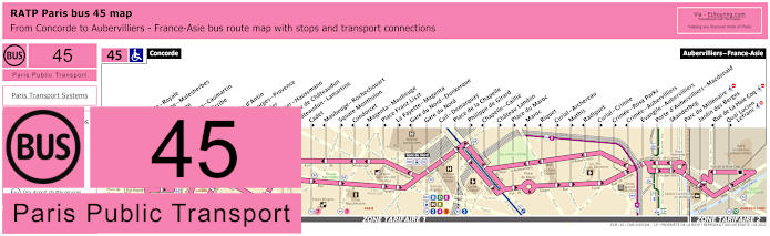
RATP Paris bus line 45 with stops, connections and street plan
So here is the RATP bus line 45, and as you can see from the maps and timetables there are numerous stops only served in a specific direction, so for the Palais Garnier you would need the Opera stop on the Rue Halevy going towards Aubervilliers - France-Asie or the Rue Scribe stop going towards Concorde for the Place de la Concorde at the start of the Avenue des Champs Elysees.
Paris bus line 45 stops:
Concorde, Concorde - Royale**, Madeleine - Malesherbes*, Madeleine, Capucines - Caumartin, Opera - Scribe*, Opera**, Chaussee d'Antin, Saint-Georges - Provence**, Le Peletier**, Le Peletier - Haussmann*, Carrefour de Chateaudun*, Chateaudun - Lamartine*, Cadet**, Maubeuge - Rochechouart*, Square Montholon**, Condorcet*, Magenta - Maubeuge*, Place Franz Liszt**, La Fayette - Magenta**, Gare du Nord - Dunkerque*, Gare du Nord, Cail - Demarquay, Place de la Chapelle, Philippe de Girard**, Chapelle - Caillie*, Chateau Landon**, Place du Maroc**, Maroc*, Riquet*, Curial - Archereau**, Mathis**, Radiguet*, Curial - Crimee**, Crimee - Rosa Parks**, Crimee - Aubervilliers*, Evangile - Aubervilliers, Porte d'Aubervilliers - Macdonald, Skanderbeg, Parc du Millenaire, Jardin des Berges, Rue de La Hale Coq*, Quai Lucien - Lefranc**, Aubervilliers - France-Asie.
* Stop served in the direction of Concorde. ** Stop served in the direction of Aubervilliers - France-Asie.
Paris bus line 45 main transport connections:
Metro Lines: 1, 2, 3, 4, 5, 7, 8, 9, 12, 14. Train Lines: A, B, D, E, H, K. Tram Line: T3b.
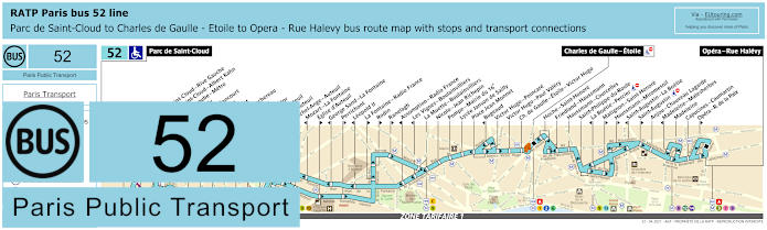
RATP Paris bus line 52 with stops, connections and route plan
When it comes to the RATP bus line 52 you have to look at the maps and timetables carefully, as travelling from Opera - Rue Halevy going in the direction of Parc de Saint-Cloud, the timetables are the same all year round, yet in the opposite direction you have times for going to Opera - Rue Halevy as well as some only going as far as Charles de Gaulle - Etoile from Parc de Saint-Cloud, not forgetting that some stops are only served in a particular direction like Opera and Opera - Rue de la Paix located by the Palais Garnier Opera House.
Paris bus line 52 stops:
Parc de Saint-Cloud, La Colline**, Pont de Saint-Cloud - Rive Gauche**, Pont de Saint-Cloud - Albert Kahn, Rhin et Danube - Metro, Rue de Silly, Rue de Billancourt, Jean Jaures, Rue de l'Est, Denfert-Rochereau, La Tourelle, Porte Molitor, Porte d'Auteuil, Gare d'Auteuil, Michel-Ange - Auteuil, Mozart - La Fontaine*, Eglise d'Auteuil**, George Sand - La Fontaine*, Perrichont**, Leopold II*, La Fontaine - Radio France**, Rodin**, Ranelagh**, Assomption - Radio France*, Les Vignes - Boulainvilliers*, La Muette - Boulainvilliers, Nicolo - Jean Richepin, Pompe - Mairie du 16e, Lycee Janson de Sailly, Place Jean Monnet, Bugeaud*, Victor Hugo - Poincare, Victor Hugo - Paul Valery, Charles de Gaulle - Etoile - Victor Hugo, Charles de Gaulle - Etoile, Hoche - Saint-Honore, Friedland - Haussmann, Haussmann - Courcelles, Saint-Philippe du Roule, La Boetie - Percier*, Matignon - Saint-Honore**, Haussmann - Miromesnil**, Saint-Augustin - La Boetie*, Saint-Augustin**, Anjou - Chaveau Lagarde, Madeleine - Malesherbes*, Madeleine, Capucines - Caumartin, Opera - Rue de la Paix**, Opera - Rue Halevy.
* Stop served in direction of Parc de Saint-Cloud. ** Stop served in direction of Opera - Rue Halevy.
Paris bus line 52 main transport connections:
Metro Lines: 1, 2, 3, 6, 7, 8, 9, 10, 12, 13, 14. Train Lines: A, C. Tram Line: T2.
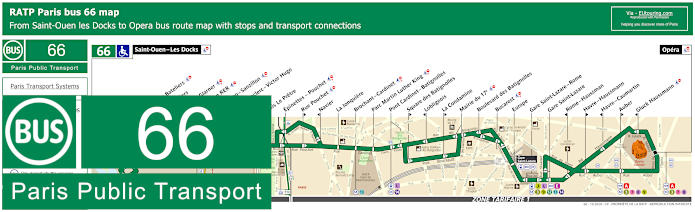
RATP Paris bus line 66 with stops, connections and street plan
The Paris bus line 66 also run by the transport company RATP goes from Opera by the Palais Garnier through to Saint-Ouen - Les Docks, however, as you will see from these bus maps and timetables you will find that the route many additional bus stops and transport connections.
Paris bus line 66 stops:
Saint-Ouen - Les Docks, Parvis des Bateliers, Les Bateliers, Capitaine Glarner, Saint-Ouen RER, Victor Hugo - Sanzillon, General Leclerc - Victor Hugo, Floreal, Bois Le Pretre, Epinettes - Pouchet, Rue Pouchet, Navier, La Jonquiere, Brochant - Cardinet, Parc Martin Luther King, Pont Cardinet - Batignolles, Square des Batignolles, Lobligeois, La Condamine, Mairie du 17e, Boulevard des Batignolles, Bucarest, Europe, Gare Saint-Lazare - Rome, Gare Saint-Lazare, Rome - Haussman, Havre - Haussmann, Havre - Caumartin, Auber, Gluck Haussmann, Opera.
Paris bus line 66 main transport connections:
Metro Lines: 3, 7, 8, 9, 12, 13, 14. Train Lines: A, C, E, J, L. Tram Line: T3b.
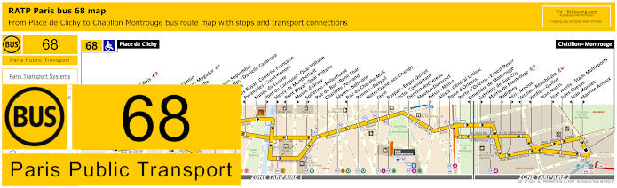
RATP Paris bus line 68 with stops, connections and street plan
Now this shows the maps and timetables for bus line 68 and is one of the options for getting to the Palais Garnier via the Opera stop in the direction of Place de Clichy terminus or the Opera - Scribe stop in the direction of Chatillon - Montrouge, however, this is also an option if you are thinking about how to get to the Casino de Paris entertainment venue via the Trinite or Liege stops.
Paris bus line 68 stops:
Place de Clichy, Blanche**, Blanche - Calais**, Liege*, Moncey**, Trinite, Chaussee d'Antin**, Haussmann - Mogador*, Opera - Scribe**, Opera*, Opera - Quatre Septembre, Petits Champs - Danielle Casanova*, Pyramides, Palais Royal - Comedie Francaise**, Pyramides - Saint-Honore*, Musee du Louvre, Pont du Carrousel - Quai Voltaire**, Henry de Montherlant**, Pont Royal - Quai Voltaire*, Musee d'Orsay**, Solferino - Bellechasse**, Rue du Bac - Rene Char, Charlotte Perriand, Sevres - Babylone, Rue du Cherche-Midi*, Rennes - Raspail, Notre-Dame-des-Champs, Vavin, Raspail - Edgar Quinet, Victor Considerant, Denfert-Rochereau, Mouton-Duvernet, Alesia - Maine**, Alesia - General Leclerc, Porte d'Orleans, Porte d'Orleans - Ernest Reyer, Cimetiere de Montrouge*, Gabrielle de Guerchy**, Mairie de Montrouge, Radiguey**, Peri - Arnoux**, Verdier - Republique*, Verdier - Guillot*, Jean Jaures, Jean Jaures - Stade Multisports**, Jules Guesde, Jean Monnet*, Maurice Arnoux**, Chatillon - Montrouge.
* Stop served in direction of Place de Clichy. ** Stop served in direction of Chatillon - Montrouge.
Paris bus line 68 main transport connections:
Metro Lines: 1, 2, 3, 4, 6, 7, 9, 10, 12, 13, 14. Train Lines: A, B, C. Tram Lines: T3a, T6.
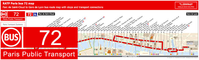
RATP Paris bus 72 map with stops, connections and street plan
However, the bus line 72 travels from Gare de Lyon train station, which you could utilise to get to the Palais Garnier by alighting at the Concorde bus stop, but please note that this is only if you are travelling in the direction of the Parc de Saint-Cloud terminus, yet as you can see from the maps and timetables this is also an option for getting to the Eiffel Tower via the Pont d'Iena bus stop.
Paris bus line 72 stops:
Parc de Saint-Cloud, La Colline, Pont de Saint-Cloud - Rive Gauche, Pont de Saint-Cloud - Albert Kahn, Rhin et Danube - Metro, Ancienne Mairie, Route de la Reine - Jean Jaures, Victor Hugo, La Tourelle, Porte de Saint-Cloud, Porte de Saint-Cloud - Murat, Versailles - Chardon Lagache, Versailles - Exelmans, Victorien Sardou, Wilhem, Pont Mirabeau, Degas, Radio France - Pont de Grenelle, Radio France, Lamballe - Ankara, Pont de Bir-Hakeim, Le Notre*, Pont d’Iena, Musee d’Art Moderne - Palais de Tokyo, Alma - Marceau, Palais de la Decouverte, Grand Palais, Cours la Reine - Chevaux de Marly*, Concorde*, Concorde - Quai des Tuileries**, Pont de Solferino - Quai des Tuileries**, Castiglione*, Pont Royal**, Pyramides - Tuileries*, Quai Francois Mitterrand**, Palais Royal - Musee du Louvre*, Louvre - Rivoli*, Pont des Arts**, Pont Neuf - Quai du Louvre**, Rivoli - Pont Neuf*, Rivoli - Chatelet*, Chatelet - Quai de Gesvres**, Hotel de Ville, Rue Vieille du Temple - Mairie du 4e*, Pont Louis Philippe**, Pont Marie*, Sully Morland, Port Henri IV**, Port de L'Arsenal*, Quai de la Rapee*, Pont Charles De Gaulle, Van Gogh**, Gare de Lyon.
* Served in direction of Parc de Saint-Cloud. ** Served in direction of Gare de Lyon.
Paris bus line 72 main transport connections:
Metro Lines: 1, 4, 5, 6, 7, 8, 9, 10, 11, 12, 13, 14. Train Lines: A, B, C, D, R.
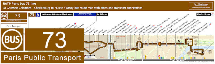
RATP Paris bus line 73 with stops, connections and street plan
Whereas this shows the RATP bus line 73 that travels from Musee d'Orsay through to La Garenne-Colombes - Charlebourg, yet as you can see from the maps and timetables, on a Sunday and on French National holidays the route terminates at La Defense, and for getting to the Palais Garnier the nearest bus stop is called Concorde - Cours la Reine, meaning a fair walk of approximately 1300 metres to this famous entertainment venue.
Paris bus line 73 stops:
La Garenne-Colombes - Charlebourg***, Nordmann***, Les Fauvelles***, Puvis de Chavannes***, Rue des Etudiants***, Leonardo de Vinci***, Faubourg de l’Arche** ***, Caron***, La Defense, Gambetta*, Boieldieu**, Alsace*, Gallieni**, Bellini**, Pont de Neuilly - Rive Gauche, Pont de Neuilly, Les Graviers, Rue de l’Hotel de Ville, Les Sablons, Marche, Montrosier*, Andre Maurois**, Palais des Congres**, Porte Maillot**, Porte Maillot - Palais des Congres*, Argentine, Charles de Gaulle - Etoile - Gde Armee, Charles de Gaulle - Etoile - Champs-Elysees, George V, La Boetie - Champs-Elysees, Rond-Point des Champs-Elysees, Champs-Elysees - Clemenceau, Concorde - Cours la Reine, Concorde*, Assemblee Nationale, Lille - Universite**, Musee d'Orsay.
* Stop served in direction of La Garenne-Colombes - Charlebourg or La Defense. ** Stop served in direction of Musee d'Orsay. *** Not served on a Sunday or French holidays.
Paris bus line 73 main transport connections:
Metro Lines: 1, 2, 6, 8, 9, 12, 13. Train Lines: A, C, L, U. Tram Line: T2.
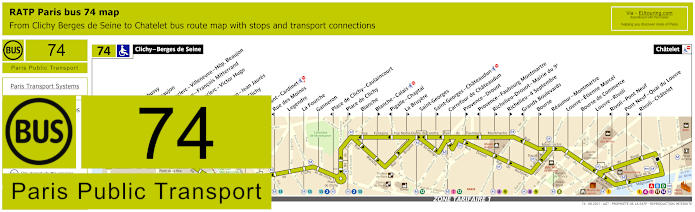
RATP Paris bus line 74 with stops, connections and street plan
Travelling from Clichy - Berges de Seine through to Chatelet for getting to the Pompidou Centre, the RATP bus line 74 is also an option for the Palais Garnier via the Carrefour de Chateaudun bus stop, but just like many other Paris bus lines many stops are only served in a particular direction, just like Saint-Georges - Chateaudun as you can see from the maps and their timetables.
Paris bus line 74 stops:
Clichy - Berges de Seine, Claude Debusy**, Hopital Beaujon, General Leclerc - Villeneuve - Hop. Beaujon, Republique - Francois Mitterrand, General Leclerc - Victor Hugo, Curton, Victor Hugo - Jean Jaures, Porte de Clichy, Boulay, Brochant - Cardinet, Rue des Moines*, Legendre, La Fourche, Ganneron, Place de Clichy - Caulaincourt*, Place de Clichy**, Blanche, Blanche - Calais**, Pigalle - Chaptal*, La Bruyere**, Saint-Georges, Saint-Georges - Chateaudun**, Carrefour de Chateaudun, Provence - Drouot**, Provence - Faubourg Montmartre*, Richelieu - Drouot - Mairie du 9e**, Richelieu - 4 Septembre**, Grands Boulevards*, Bourse**, Reaumur - Montmartre, Louvre - Etienne Marcel, Bourse de Commerce, Louvre - Rivoli, Rivoli - Pont Neuf*, Pont Neuf - Quai du Louvre**, Rivoli - Chatelet*, Chatelet.
* Stop served in direction of Clichy - Berges de Seine. ** Stop served in direction of Chatelet.
Paris bus line 74 main transport connections:
Metro Lines: 1, 2, 3, 4, 7, 8, 9, 11, 12, 13, 14. Train Lines: A, B, C, D. Tram Line: T3b.
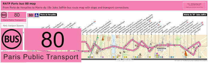
RATP Paris bus line 80 with stops, connections and street plan
The RATP bus line 80 starts from Porte de Versailles by the Parc des Expositions Paris Exhibition centre and is also the terminus stop required for getting to the Dome de Paris events and entertainment venue, and travelling through to Mairie du 18e - Jules Joffrin there are numerous stops on route including Gare Saint-Lazare - Rome for the Palais Garnier.
Paris bus line 80 stops:
Porte de Versailles, Firmin Gillot**, Boulevard Victor*, Hameau*, Vaugirard - Croix Nivert**, Hopital de Vaugirard**, Duranton*, Convention - Lecourbe*, Convention - Vaugirard**, Abbe Groult, Vaugirard**, Mairie du 15e, Peclet**, Cambronne - Lecourbe*, Miollis*, Fondary**, Cambronne, La Motte-Picquet - Grenelle, General de Bollardiere, Ecole Militaire, Bosquet - Grenelle, Bosquet - Saint-Dominique, Bosquet - Rapp, Alma - Marceau, Montaigne - Francois 1er, Rond-Point des Champs-Elysees, Rd-Pt des Champs-Elysees - F. D. Roosevelt*, Rd-Pt des Champs-Elysees - Matignon**, Saint-Philippe du Roule*, Matignon - Saint-Honore**, Haussmann - Miromesnil**, La Boetie - Miromesnil*, Saint-Augustin, Pasquier - Anjou*, Gare Saint-Lazare - Rome, Europe, Bucarest, Place de Clichy, Place de Clichy - Caulaincourt*, Clichy - Caulaincourt**, Damremont - Caulaincourt, Square Caulaincourt, Lamarck - Caulaincourt, Custine - Mont-Cenis, Custine - Ramey*, Marcadet*, Mairie du 18e - Jules Joffrin.
* Stop served in direction of Porte de Versailles. ** Stop served in direction of Mairie du 18e - Jules Joffrin.
Paris bus line 80 main transport connections:
Metro Lines: 1, 2, 3, 6, 8, 9, 10, 12, 13, 14. Train Lines: C, E, J, L. Tram Lines: T2, T3a.
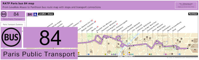
RATP Paris bus line 84 with stops, connections and street plan
The nearest stop to Palais Garnier when utilising the bus line 84 is called the Madeleine bus stop and travelling from Levallois - Alsace in ticket tariff zone 2 through to the Pantheon in Paris zone 1, as you can see from the street maps this will also get you to Luxembourg Gardens and its many attractions.
Paris bus line 84 stops:
Levallois - Alsace, Centre Commercial*, Reims - Hotel des Impots**, Wilson - Courcelles*, Reims - Pitet**, Porte de Courcelles, Pereire - Le Chatelier**, Pereire*, Pereire - Marechal Juin, Wagram - Courcelles, Courcelles, Murillo, Ruysdael - Parc Monceau**, Haussmann - Miromesnil, Saint-Augustin, Anjou - Chauveau Lagarde, Madeleine, Concorde - Royale, Assemblee Nationale, Lille -Universite, Solferino - Bellechasse, Rue du Bac - Rene Char, Charlotte Perriand, Sevres - Babylone, Michel Debre, Saint-Sulpice, Musee du Luxembourg, Senat, Luxembourg, Pantheon.
* Stop served in the direction of Levallois - Alsace. ** Stop served in the direction of Pantheon.
Paris bus line 84 main transport connections:
Metro Lines: 1, 2, 3, 4, 8, 9, 10, 12, 13, 14. Train Lines: B, C.
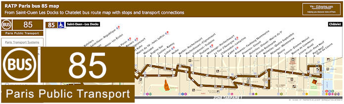
RATP Paris bus line 85 with stops, connections and street plan
Alternatively, you have the bus line 85 that goes between Saint-Ouen - Les Docks and Chatelet with many bus stop in between such as Porte de Clignancourt and Louvre - Rivoli, yet for Palais Garnier as you can see from the street maps and timetables you would need the Richelieu - Quatre Septembre stop on Rue de Richelieu if heading towards Chatelet, but unfortunately if going in the opposite direction it would not be a convenient bus route unless you like walking, as you would need the Grands Boulevards stop.
Paris bus line 85 stops:
Saint-Ouen - Les Docks, Parvis des Bateliers, Mairie de Saint-Ouen - Republique, Ernest Renan, Eugene Lumeau - Les Ecoles, Paul Bert, Marche aux Puces, Michelet - Rosiers, Porte de Clignancourt, Albert Kahn, Mairie du 18e - Jules Joffrin, Marcadet**, Eugene Sue*, Custine - Ramey**, Labat*, Muller, Barbes - Rochechouart**, Rochechouart - Clignancourt, Condorcet - Trudaine*, Trudaine**, Maubeuge - Rochechouart*, La Tour d’Auvergne**, Chateaudun - Lamartine**, Cadet*, Provence - Faubourg Montmartre*, Provence - Drouot**, Richelieu - Drouot - Mairie du 9e**, Grands Boulevards*, Richelieu - Quatre Septembre**, Reaumur - Montmartre, Bourse**, Louvre - Etienne Marcel, Bourse de Commerce, Louvre - Rivoli, Rivoli - Pont Neuf*, Pont Neuf - Quai du Louvre**, Chatelet.
* Stop served in direction of Saint-Ouen - Les Docks. ** Stop served in direction of Chatelet, Paris.
Paris bus line 85 main transport connections:
Metro Lines: 1, 2, 3, 4, 7, 8, 9, 11, 12, 13, 14. Train Lines: A, B, D. Tram Line: T3b.
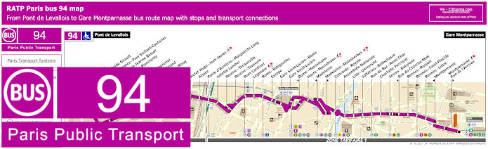
RATP Paris bus line 94 with stops, connections and street plan
So here you have the bus maps and timetables for bus line 94 that goes between Pont de Levallois and Gare Montparnasse and as you can see from these street maps with their timetables, the nearest stop to Palais Garnier is the Havre - Haussmann bus stop, plus this bus route can be utilised to get close to numerous attractions in Paris like the Musee d'Orsay and Tuileries Gardens.
Paris bus line 94 stops:
Pont de Levallois, Pompidou, Parc Mathilde Girault, Anatole France - Paul Vaillant Couturier, Place Marie-Jeanne Bassot, Parc de la Planchette, Baudin, Vaillant-Couturier, Aristide Briand, Rouquier - Rivay, Marjolin, Trezel, Victor Hugo - Jean Jaures, Alsace, Porte d'Asnieres - Marguerite Long, Juliette Lamber, Pereire - Tocqueville, Pereire - Saussure, Pont Cardinet, Legendre, Rome - Batignolles, Europe, Gare Saint-Lazare - Rome, Gare Saint-Lazare, Rome - Haussmann, Havre - Haussmann, Madeleine, Madeleine - Malesherbes, Concorde - Royale, Assemblee Nationale, Lille - Universite, Solferino - Bellechasse, Rue de Bac - Rene Char, Charlotte Perriand, Sevres - Babylone, Rue du Cherche-Midi, Rennes - Raspail, Rennes - Saint-Placide, Rennes - Littre, Montparnasse, Montparnasse - Rue de l'Arrivee, Gare Montparnasse.
Paris bus line 94 main transport connections:
Metro Lines: 1, 2, 3, 4, 6, 8, 9, 10, 12, 13, 14. Train Lines: E, J, L, N. Tram Lines: T3b.
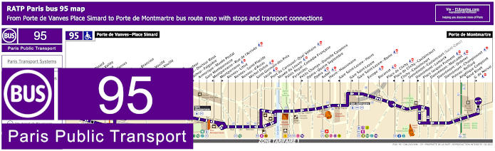
RATP Paris bus line 95 with stops, connections and street plan
Going from Porte de Vanves - Place Simard to Porte de Montmartre on different outskirts of the city, the Paris bus line 95 has numerous stops between, many of them having transport connections including that of Auber, which is one of the options for getting to Palais Garnier or you have the Opera stop and the Havre - Haussmann stop as well, plus all of these are options for getting to the Olympia Concert Hall.
Paris bus line 95 stops:
Porte de Vanves - Place Simard, Adolphe Pinard*, Pont de la Vallee*, Bartholome*, Porte de Vanves**, Brancion*, Chauvelot**, Morillons - Brancion*, Morillons**, Brancion - Vouille*, Labrouste - Vouille**, Alleray*, Falguiere**, Procession*, Institut Pasteur, Pasteur - Docteur Roux*, Pasteur - Falguiere**, Armorique - Musee Postal, Gare Montparnasse, Montparnasse - Rue de l'Arrivee*, Montparnasse**, Rennes - Littre, Rennes - Saint-Placide, Rennes - d'Assas, Michel Debre, Saint-Germain-des-Pres, Jacob, Pont du Carrousel - Quai Voltaire, Musee du Louvre, Palais Royal - Comedie Francaise, Pyramides, Petits Champs - Danielle Casanova**, Opera - Quatre Septembre, Opera, Auber, Havre - Haussmann*, Gare Saint-Lazare - Havre*, Gare Saint-Lazare**, Gare Saint-Lazare - Rome, Europe, Bucarest, Place de Clichy, Place de Clichy - Caulaincourt*, Clichy - Caulaincourt**, Damremont - Caulaincourt (Sacre-Coeur), Damremont - Lamarck**, Place Jacques Froment, Damremont - Marcadet, Damremont - Ordener, Damremont - Championnet, Poteau - Belliard, Angelique Compoint, Rene Binet, G. de Nerval**, Porte de Montmartre.
* Stop served in direction of Porte de Vanves - Place Simard. ** Stop served in direction of Porte de Montmartre.
Paris bus line 95 main transport connections:
Metro Lines: 1, 2, 3, 4, 6, 7, 8, 9, 10, 12, 13, 14. Train Lines: A, E, J, L, N. Tram Line: T3a.
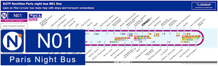
Paris Noctilien night bus N01 map with stops and transport connections
Now as you may have realised, mos Paris public transport stops running during the early hours, and this is where the Noctilien buses take over as these are a night bus service operating between around 12:30am and 5:30am. So if you are leaving the area around Palais Garnier late, you could utilise the Noctilien N01, which is referred to as Circulaire Interieure running in a complete circuit from Gare de l'Est train station, and as you can see from the maps, the stops required would either be Gare Saint-Lazare or Trinite.
Paris night bus line N01 stops:
Gare de l'Est, Jacques Bonsergent, Republique, Oberkampf - Filles du Calvaire, Saint-Gilles - Chemin Vert, Bastille - Beaumarchais, Bastille, Lyon - Ledru-Rollin, Gare de Lyon - Diderot, Quai de la Rapee, Gare d'Austerlitz, Saint-Marcel - La Pitie, Saint-Marcel - Jeanne d'Arc, Les Gobelins, Port Royal - Berthollet, Observatoire - Port Royal, Campagne Premiere, Vavin, Montparnasse - Rue de l'Arrivee, Gare Montparnasse, Montparnasse, Rennes - Littre, Rennes - Saint-Placide, Rennes - d'Assas, Michel Debre, St-Germain-des-Pres, Pont du Carrousel - Quai Voltaire, Henry de Montherlant, Assemblee Nationale, Pont Alexandre III, Palais de la Decouverte, Rond-Point des Champs-Elysees - Matignon, Haussmann - Miromesnil, Saint-Augustin, Gare Saint-Lazare, Trinite, Liege, Place de Clichy, Blanche, Pigalle, Rochechouart - Martyrs, Anvers - Sacre-Coeur, Rochechouart - Clignancourt, Barbes - Rochechouart, Magenta - Mauberge - Gare du Nord, La Fayette - Magenta - Gare du Nord, Gare de l'Est.
Paris night bus line N01 main transport connections:
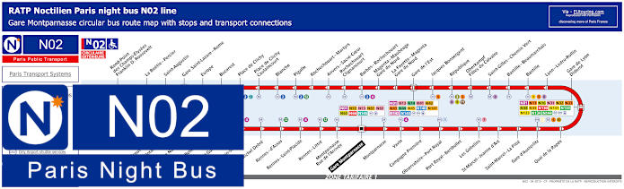
Paris Noctilien night bus N02 map with stops and transport connections
Whereas the Noctilien N02 night bus service operated by RATP is referred to as the Circulaire Exterieure and also travels in a complete circuit, but from Gare Montparnasse, and as you can see from these Paris night bus maps and timetables, for leaving or getting back to the area around Palais Garnier you would need Gare Saint-Lazare - Rome bus stop.
Paris night bus line N02 stops:
Gare Montparnasse, Montparnasse, Vavin, Campagne Premiere, Observatoire - Port Royal, Port Royal - Berthollet, Les Gobelins, Saint-Marcel - Jeanne d'Arc, Saint-Marcel - La Pitie, Gare d'Austerlitz, Quai de la Rapee, Gare de Lyon - Diderot, Lyon - Ledru-Rollin, Bastille, Bastille - Beaumarchais, Saint-Gilles - Chemin Vert, Oberkampf - Filles du Calvaire, Republique, Jacques Bonsergent, Gare de l'Est, La Fayette - Magenta - Gare du Nord, Magenta - Maubeuge - Gare du Nord, Barbes - Rochechouart, Rochechouart - Clignancourt, Anvers - Sacre-Coeur, Rochechouart - Martyrs, Pigalle, Blanche, Place de Clichy - Caulaincourt, Place de Clichy, Bucarest, Europe, Gare Saint-Lazare - Rome, Saint-Augustin, La Boetie - Percier, Rond-Point des Champs-Elysees - Franklin D. Roosevelt, Palais de la Decouverte, Pont Alexandre III, Assemblee Nationale, Solferino - Bellechasse, Saint-Guillaume, Saint-Germain-des-Pres, Michel Debre, Rennes - d'Assas, Rennes - Saint-Placide, Rennes - Little, Montparnasse - Rue de l'Arrivee, Gare Montparnasse.
Paris night bus line N02 main transport connections:
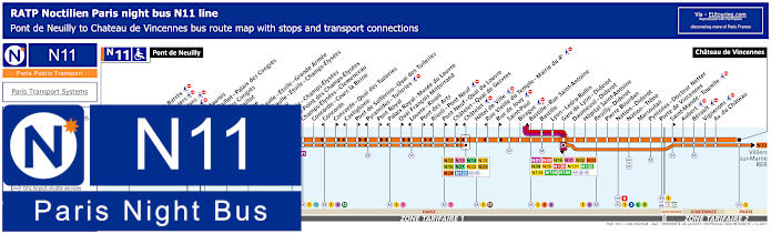
Paris Noctilien night bus N11 map with stops and transport connections
Travelling from Pont de Neuilly this is an option for getting to Chateau de Vincennes or from this area as that is the opposite terminus, and the Paris Noctilien N11 night bus has stops close to many lively and popular areas of Paris including Porte Maillot, Bastille and Concorde - Cours la Reine, with the latter being the night bus stop you would need after leaving the area around Palais Garnier.
Paris night bus line N11 main transport connections:
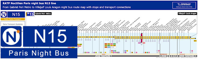
Paris Noctilien night bus N15 map with stops and transport connections
However, these maps and timetables show the Noctilien night bus line N15 that travels from the Asnieres commune, or area, of the Paris region at Gabriel Peri - Metro through to Villejuif - Louis Aragon, and the Opera stop is the closest to the famous Palais Garnier Opera House, yet please not some stops are direction dependant like Opera - 4 Septembre.
Paris night bus line N15 main transport connections:
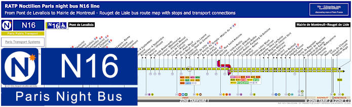
Paris Noctilien night bus N16 map with stops and transport connections
The Noctilien N16 Paris night bus travels from Pont de Levallois to Mairie de Montreuil - Rouget de Lisle, and as you can see from the maps and timetables, just like many other Paris Noctilien buses, some stops are only served in a particular direction such as Pere Lachaise, so for Palais Garnier you would need the Opera night bus stop.
Paris night bus line N16 main transport connections:
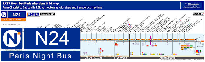
Paris Noctilien night bus N24 map with stops and transport connections
Travelling from Paris at the Chatelet transport hub the Noctilien N24 night bus goes through various areas of the Paris region like Puteaux and Colombes to Sartrouville and the terminus of Starouville RER, yet for getting back to the area around Palais Garnier or when leaving, you would need to get to the Concorde - Cours la Reine night bus stop, at an approximate walking distance of 1300 metres.
Paris night bus line N24 main transport connections:
Metro Lines: 1, 2, 4, 6, 7, 8, 9, 11, 12, 14. Train Lines: A, B, C, D, J, L, U. Tram Line: T2. Bus Lines: N01, N02, N11, N12, N13, N14, N15, N16, N21, N22, N23, N122, N153.
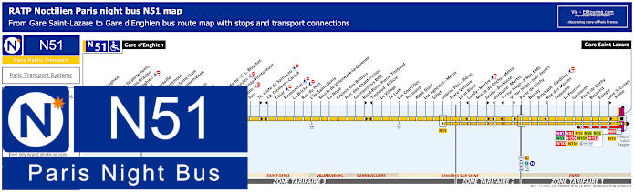
Paris Noctilien night bus N51 map with stops and transport connections
Within a short walk of Palais Garnier you have the Gare Saint-Lazare train station, and the Paris Noctilien N51 night bus goes from here through to Gare d'Enghien and when you look at the maps and timetables carefully, you will see there are different start times from specific points including Porte de Clichy and also different ticket tariff zones.
Paris night bus line N51 main transport connections:
Metro Lines: 3, 12, 13, 14. Train Lines: C, E, J, L. Tram Line: T3b. Bus Lines: N01, N02, N15, N16, N52, N53, N150, N151, N152, N153, N154.
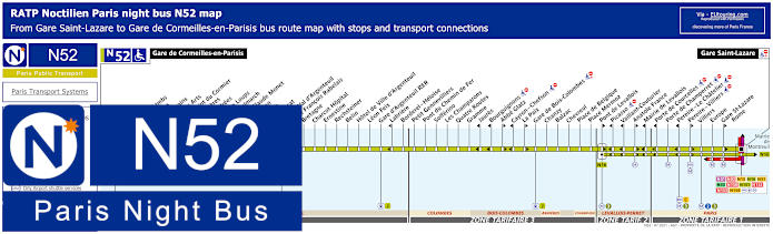
Paris Noctilien night bus N52 map with stops and transport connections
Again travelling from Gare Saint-Lazare, the Noctilien night bus line N52 goes through to Gare de Corneilles-en-Parisis having numerous stops on its route through different areas of the Paris region, Ile de France, but please note that some night bus stops are only served in a particular direction.
Paris night bus line N52 main transport connections:
Metro Lines: 2, 3, 12, 13, 14. Train Lines: C, E, J, L. Bus Lines: N01, N02, N15, N16, N51, N53, N150, N151, N152, N153, N154.
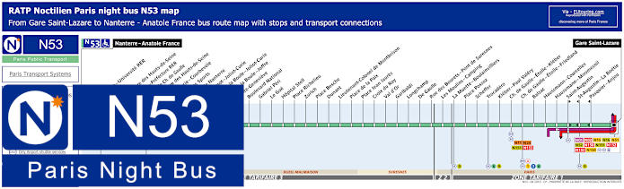
Paris Noctilien night bus N53 map with stops and transport connections
Here you can see the maps and timetables for the Noctilien bus line N53, which is a night bus again going from Gare Saint-Lazare but through to Nanterre - Anatole France and on route it has night bus stops at many locations with transport connections like at Charles de Gaulle - Etoile - Friedland and Trocadero for the famous Trocadero Gardens with its elevated views to the Eiffel Tower.
Paris night bus line N53 main transport connections:
Metro Lines: 1, 2, 3, 6, 9, 12, 13, 14. Train Lines: A, E, J, L. Bus lines: N01, N02, N11, N15, N16, N24, N51, N52, N150, N151, N152, N153, N154.
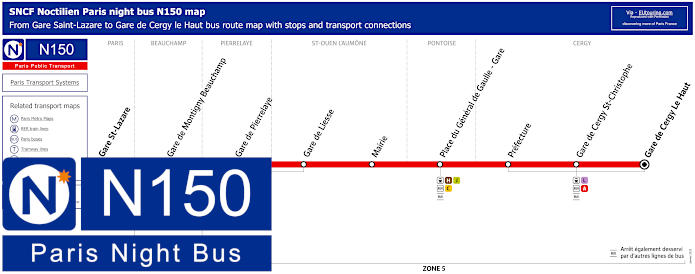
Paris Noctilien night bus N150 map with stops and transport connections
Within walking distance of the Palais Garnier, these maps and timetables show the Noctilien N150 night bus line that goes from Gare Saint-Lazare at Cour de Rome through to Gare de Cergy le Haut at the Gare Routiere, which is bus station in French, and this has only a few stops in between, but all at key locations of other train stations such as Gare de Pontoise.
Paris night bus line N150 main transport connections:
Metro Lines: 3, 12, 13, 14. Train Lines: A, C, E, H, J, L. Bus Lines: N01, N02, N15, N16, N51, N52, N53, N151, N152, N153, N154.
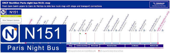
Paris Noctilien night bus N151 map with stops and transport connections
Operated by SNCF, the Noctilien bus line N151 also travels from Gare Saint Lazare at the Cour du Rome stop within walking distance of Palais Garnier and goes through to Gare de Mantes la Jolie at the Place du 8 Mai 1945 with various night bus stops on route including Charles de Gaulle - Friedland close by the Arc de Triomphe at the top of the Champs Elysees Avenue.
Paris night bus line N151 main transport connections:
Metro Lines: 3, 9, 12, 13, 14. Train lines: E, J, L. Bus Lines: N01, N02, N11, N15, N16, N24, N51, N52, N53, N150, N152, N153, N154.
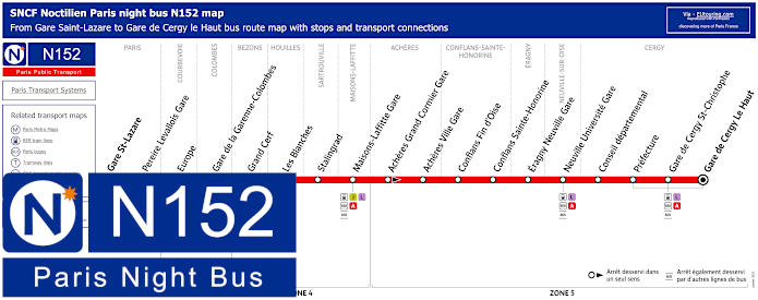
Paris Noctilien night bus N152 map with stops and transport connections
However, this shows the maps and timetables for the Noctilien N152 night bus line that travels from Paris close to the Palais Garnier at Gare Saint-Lazare through to Cergy le Haut Gare at its bus station, or Gare Routiere, travelling via the Maisons Laffitte Gare, plus you will notice that there is one extra time going from Paris Saint-Lazare on weekends and on French National holidays.
Paris night bus line N152 main transport connections:
Metro Lines: 3, 9, 12, 13, 14. Train Lines: A, E, J, L. Bus Lines: N01, N02, N15, N16, N24, N51, N52, N53, N150, N151, N153, N154.
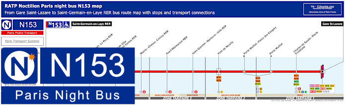
Paris Noctilien night bus N153 map with stops and transport connections
So here we have the Noctilien N153 night bus line that travels from Gare Saint-Lazare close to the Palais Garnier through to Saint-Germain-en-Laye RER close to the Chateau and Domaine of the National Archaeology Museum, and as you will see from the maps and timetables there are also various times depending upon your start point and the night of your travel to or from each area.
Paris night bus line N153 main transport connections:
Metro Lines: 1, 2, 3, 6, 9, 12, 13, 14. Train Lines: A, C, E, J, L. Tram Line: T13 Bus Lines: N01, N02, N11, N15, N16, N24, N51, N52, N53, N150, N151, N152, N154.
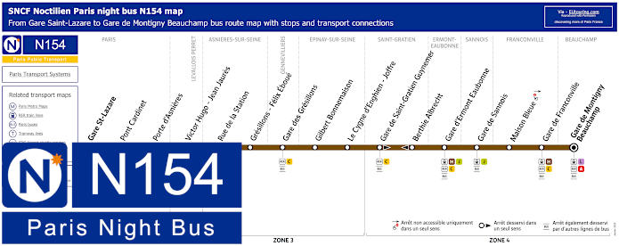
Paris Noctilien night bus N154 map with stops and transport connections
Alternatively you have the Noctilien bus line N154 that also goes from Gare Saint-Lazare train station at the Cour de Rome stop within walking distance of the Palais Garnier and this night bus has a route travelling to Gare de Montigny Beachamp at the Place de la Gare stop, yet please take not of the maps and timetables as there are several night bus stop that have a different pick up and drop off point depending upon what direction you are travelling in such as at Maison Bleue.
Paris night bus line N154 main transport connections:
Metro Lines: 3, 9, 12, 13, 14. Train Lines: A, C, E, H, J, L. Bus Lines: N01, N02, N15, N16, N51, N52, N53, N150, N151, N152, N153.
Paris Open Tour bus sightseeing tour map for Blue, Red and Green bus lines with stops and timetables
Whereas if you are on holiday in Paris and are thinking of discovering lots of different monuments and attractions in the city, then you may be pleased to know that there is a bus tour company called Open Tour that offer sightseeing tours through a hop on and hop off service with 3 different routes. So for getting to the Palais Garnier you have several options, as the Open Tour Visitor Centre is located at 13 Rue Auber.
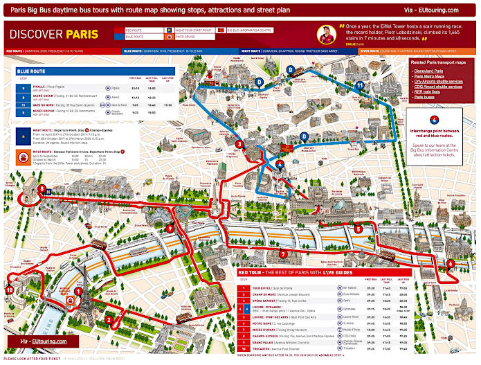
Big Bus Paris sightseeing tour map for Red and Blue bus lines with stops and timetables
Alternatively Big Bus is another tour bus company and Big Bus Paris offer sightseeing tours with 2 different routes, also as a hop on and hop off service, and you can see with the maps and information the route you would need for getting to Palais Garnier is the Red bus tour and stop 3 called Opera Garnier that faces 15 Rue Scribe, right by where the RoissyBus stops.
1: Tour Eiffel - Quai Branly, Entree 2 Tour Eiffel 2: Champ de Mars - Avenue Joseph Bouvard 3: Opera Garnier - Facing 15 Rue Scribe (next to the RoissyBus airport shuttle bus stop) 4: Louvre - Pyramide / Big Bus Information Centre - 11 Avenue de l’Opera (by Big Bus information center) 5: Louvre - Pont des Arts - Quai Francois Mitterrand (near Pont des Arts) 6: Notre Dame - 3 Rue Lagrange (outside souvenir shop, opposite Square Rene Viviani) 7: Musee d'Orsay - 58 Place Henry de Montherlant (facing the museum by Quai Anatole France) 8: Champs-Elysees - 156 Avenue des Champs-Elysees (facing the Arc de Triomphe by Rue de Tilsitt) 9: Grand Palais - Avenue Winston Churchill (facing the Grand Palais and Petit Palais) 10: Trocadero - Avenue Paul Doumer (next to the Palais de Chaillot close to the Statue of Benjamin Franklin)
Big Bus Paris daytime sightseeing tour maps with stops and timetables:
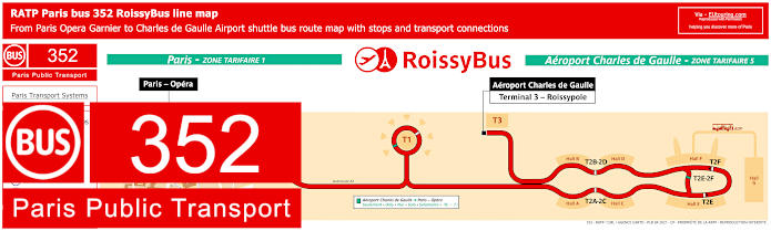
Paris RoissyBus line 352 with stops, connections and street plan
However, if you are thinking of getting from Paris to Charles de Gaulle Airport after enjoying a visit to the Palais Garnier Opera House or one of their performances, then you will be pleased to know that there is a dedicated bus service run by RATP called RoissyBus, and as you can see from the maps, timetables and information, the RoissyBus stop is located on the Rue Scribe close to the corner of Rue Auber to the side of Palais Garnier.
Palais Garnier floor plan of different rooms and points of interest
Here is a visitors plan of the historical Palais Garnier Opera House showing the layout of this grand and ornate opera house in Paris with its various points of interest from the main facade entrance, front foyer to the impressive grand staircase through to the auditorium and location of its museum, library plus much more.
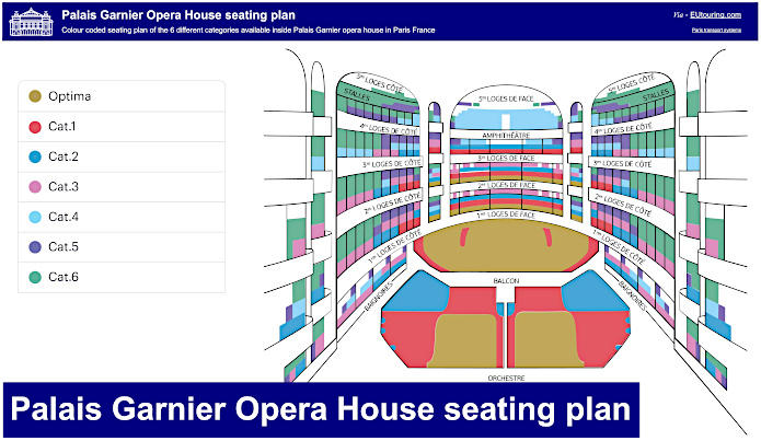
Palais Garnier Opera House seating plan of the 6 different categories
Here you can see the Palais Garnier seating plan showing the different categories of seats and where they are positioned such as the balconies and stalls, through to the most expensive seats being the Optima category being right in front of the stage with optimum viewing, and as you would expect, the costs vary greatly between the different areas, but also differ for each performance.
Palais Garnier opera house seating plans available:
Palais Garnier, Place de l'Opera, 8 Rue Scribe, 75009, Paris, Ile de France, France GPS: 48.871275, 2.332068 Tel: 0033 1 40 01 17 89 Information: 0033 1 40 01 18 50


