How to get to Palais des Congres in Paris using public transport
Palais des Congress Paris is a concert venue and a convention centre with more than 200 events organised here each year for both professionals and the public, and with over 19,000 square metres of exhibition spaces including an amphitheatre that caters for over 3,700 people, this event venue also houses a shopping mall. So below you can see how to get to Palais des Congres in Paris via public transport, which includes maps, plans and timetables that can all be downloaded by PDF or image formats for your convenience.
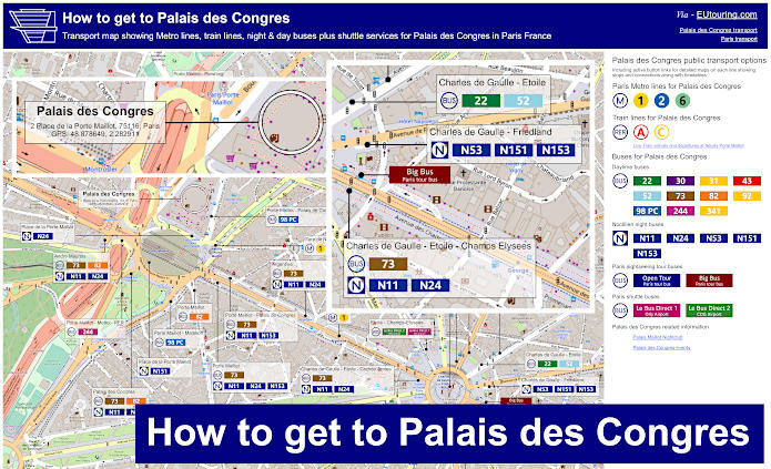
Palais des Congres transport map of Metro lines, trains, night and bus lines with stops, connections and street plan
Here you can see a street map showing the various different transport options for Palais des Congres including Metro and RER stations, bus stops and the locations for the Paris airport shuttle services that will get you to this events and entertainment venue plus conference centre.
How to get to Palais des Congres public transport maps available:
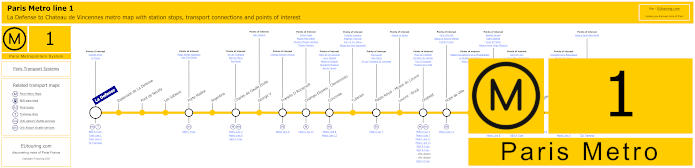
Paris Metro Line 1 map with stations, connections and points of interest
This map shows the Metro line 1, which travels from the business district of La Defense through to the Medieval castle of Chateau de Vincennes with a stop on route called Porte Maillot for the Palais des Congres that you can access directly, yet as you can see, this Metro line also goes to Charles de Gaulle Etoile by the Arc de Triomphe and is also a great option for other Paris tourist attractions such as Palais Royal - Musee du Louvre, Bastille, etc.
Metro Line 1 stops:
La Defense, Esplanade de La Defense, Pont de Neuilly, Les Sablons, Porte Maillot, Argentine, Charles de Gaulle Etoile, George V, Franklin D Roosevelt, Champs-Elysees - Clemenceau, Concorde, Tuileries, Palais Royal - Musee du Louvre, Louvre - Rivoli, Chatelet, Hotel de Ville, Saint-Paul, Bastille, Gare de Lyon, Reuilly - Diderot, Nation, Porte de Vincennes, Saint-Mande, Berault, Chateau de Vincennes.
Metro line 1 main transport connections:
Metro Lines: 2, 4, 5, 6, 7, 8, 9, 11, 12, 13, 14. Train Lines: A, B, C, D, L, R, U. Tram Lines: T2, T3a, T3b.
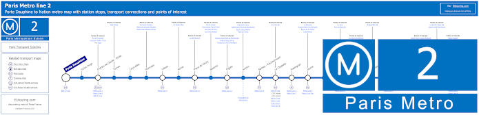
Paris Metro Line 2 map with stations, connections and points of interest
Whereas the Metro Line 2 goes from Porte Dauphine to Nation and the Metro stop you would need for the Palais des Congres is the Charles de Gaulle - Etoile stop, which is a distance of approximately 1100 metres walk from the events venue and conference centre.
As points of interest, the station is located underneath the Arc de Triomphe and was originally named just Etoile, but was changed to Charles de Gaulle - Etoile in 1970 in honour of the French President who was leader of the Free French Forces during World War II.
Additionally, the Tomb of the Unknown Soldier was placed under the centre of the triumphal arch back in 1920 in honour of soldiers who died in World War I, with its eternal flame being re-lit in a ceremony every evening at 6:30pm.
Metro Line 2 stops:
Porte Dauphine, Victor Hugo, Charles de Gaulle - Etoile, Ternes, Courcelles, Monceau, Villiers, Rome, Place de Clichy, Blanche, Pigalle, Anvers, Barbes - Rochechouart, La Chapelle, Stalingrad, Jaures, Colonel Fabien, Belleville, Couronnes, Menilmontant, Pere Lachaise, Philippe Auguste, Alexandre Dumas, Avron, Nation.
Metro line 2 main transport connections:
Metro Lines: 1, 3, 4, 5, 6, 7, 7bis, 9, 11, 12, 13. Train Lines: A, B, C, D, E, H, K, Funiculaire du Montmartre.
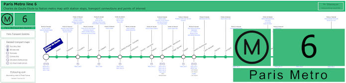
Paris Metro Line 6 map with stations, connections and points of interest
Whereas the Metro Line 6 goes between Nation and Charles de Gaulle - Etoile, which like above, you would need this latter terminus for the Palais des Congres at approximately 1100 away, yet this Metro line is also a way for how to get to the Eiffel Tower via the Trocadero or Bir-Hakeim stops along with other tourist attractions on its route.
Metro line 6 stops:
Charles de Gaulle - Etoile, Kleber, Boissiere, Trocadero, Passy, Bir-Hakeim, Dupleix, La Motte-Picquet - Grenelle, Cambronne, Sevres - Lecourbe, Pasteur, Montparnasse - Bienvenue, Edgar Quinet, Raspail, Denfert-Rochereau, Saint-Jacques, Glaciere, Corvisart, Place d'Italie, Nationale, Chevaleret, Quai de la Gare, Bercy, Dugommier, Daumesnil, Bel-Air, Picpus, Nation.
Metro line 6 main transport connections:
Metro Lines: 1, 2, 4, 5, 7, 8, 9, 10, 12, 13, 14. Train Lines: A, B, C, N. Bus Line: OrlyBus.
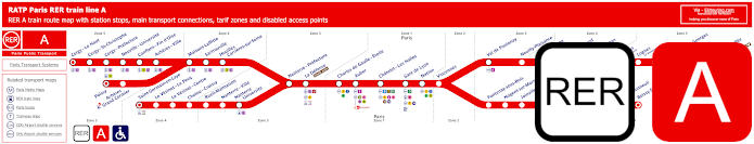
Red RER A train line map showing station stops, line branches, transport connections and zones
Although here you can see the RER A line travelling from central Paris at places like Paris Gare de Lyon, Chatelet Les Halles and Auber, although another is the Charles de Gaulle Etoile train station, which is the train station you would need for Palais des Congress, but this goes to the outskirts of the Paris region including getting to Disneyland Paris.
Paris RER A train line stops:
Cergy le Haut*, Cergy Saint-Christophe, Cergy Prefecture, Neuville Universite, Conflans Fin d’Oise, Acheres Ville, Maisons-Laffitte, Sartrouville, Houilles - Carrieres sur Seine, Nanterre Prefecture, La Defense (Grande Arche), Charles de Gaulle Etoile, Auber, Chatelet Les Halles, Paris Gare de Lyon, Nation, Vincennes, Val de Fontenay, Neuilly Plaisance, Bry sur Marne, Noisy le Grand - Mont d’Est, Noisy Champs, Noisiel, Lognes, Torcy, Bussy Saint-Georges, Val d’Europe, Marne la Vallee - Chessy (Parcs Disneyland)*, Poissy*, Acheres - Grand Cormier, Saint-Germain en Laye*, Le Vesinet Le Pecq, Le Vesinet Centre, Chatou Croissy, Rueil Malmaison, Nanterre Ville, Nanterre University, Fontenay sous Bois, Nogent sur Marne, Joinville le Pont, Saint-Maur - Creteil, Le Parc de Saint-Maur, Champigny, La Varenne - Chennevieres, Sucy Bonneuil, Boissy Saint-Leger*.
* Terminus Points.
Paris RER A train line main transport connections:
Metro Lines: 1, 2, 3, 4, 6, 7, 8, 9, 11, 14. Train Lines: B, D, E, J, L, R, U, TGV. Tram Lines: T2, 13. Bus Lines: 393, RoissyBus, TVM (14).
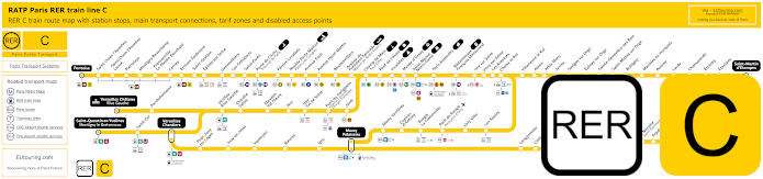
Yellow RER C train line map showing station stops, line branches, transport connections and zones
Whereas the RER C also goes from central Paris at places like Invalides and Champs de Mars - Tour Eiffel, yet as you can see from the maps, there is a train station called Neuilly Porte Maillot for the Palais des Congres, which has a direct link to the event venue and convention centre. Yet this train line has several other branches and transport options depending upon where you are arriving from, but you can see the arrival and departure times at Neuilly Porte Maillot below.
Paris RER C train line stops:
Pontoise*, St-Ouen l'Aumone, St-Ouen l'Aumone - Liesse, Pierrelaye, Montigny Beauchamp, Francoville - Le Plessis-Bouchard, Cernay, Ermont Eaubonne, St-Gratien, Epinay-sur-Seine, Gennevilliers, Les Gresillons, St-Ouen, Porte de Clichy, Pereire Levallois, Neuilly - Porte Maillot (Palais des Congres), Avenue Foch, Avenue Henri Martin, Boulainvilliers, Avenue du Pdt Kennedy (Maison de Radio France), Champ de Mars (Tour Eiffel), Pont d'Iena, Invalides, Musee d'Orsay, St-Michel (Notre Dame), Paris Gare d'Austerlitz, Bibliotheque Francois Mitterrand, Ivry-sur-Seine, Vitry-sur-Seine, Les Ardoines, Choisy le Roi, Villeneuve le Roi, Ablon, Athis Mons, Juvisy, Savigny-sur-Orge, Epinay-sur-Orge, Ste-Genevieve des Bois, St-Michel-sur Orge, Bretigny, Marolles en Hurepoix, Bouray, Lardy, Chamarande, Etrechy, Etampes, St-Martin d'Etampes*, Versailles Chateau Rive Gauche*, Porchefontaine, Viroflay Rive Gauche, Chaville - Velizy, Meudon - Val Fleury, Issy, Issy - Val de Seine, Pont du Garigliano (Hopital Europeen Georges Pompidou), Javel, St-Quentin en Yvelines*, St-Cyr, Versailles Chantiers**, Petit Jouy les Loges, Jouy en Josas, Vauboyen, Bievres, Igny, Massy Palaiseau**, Massy Verrieres, Chemin d'Antony, Rungis La Fraternelle, Pont de Rungis (Aeroport d'Orly), Orly Ville, Les Saules, Longjumeau, Chilly Mazarin, Gravigny Balizy, Petit Vaux, La Norville (St-Germain les Arpajon), Arpajon, Egly, Breuillet (Bruyeres le Chatel), St-Cheron, Sermaise, Dourdan, Dourdan la Foret*.
* Terminus Points. ** RER C Transfer Points.
Paris RER C train line main transport connections:
Metro Lines: 1, 2, 3, 4, 5, 6, 8, 9, 10, 12, 13, 14. Train Lines: B, D, H, J, N, U, TGV, TER. Tram Lines: T1, T2, T3a, T3b, T6, T7, T8, T9, T11, T13. Bus Lines: 183, 393, PC (98), TVM (14).
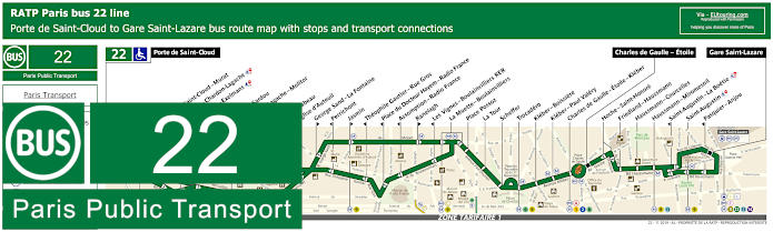
RATP Paris bus line 22 with stops, connections and street plan
Here we have the bus line 22 that travels from Porte de Saint-Cloud through to Gare Saint-Lazare, although as you can tell from the bus maps and timetables, sometimes it only travels through to Charles de Gaulle Etoile, and this is actually the stop you would need for getting to Palais des Congres approximately 1100 metres away.
Paris bus line 22 stops:
Porte de Saint-Cloud, Porte de Saint-Cloud - Murat, Versailles - Chardon-Lagache, Versailles - Exelmans**, Jouvenet*, Victorien Sardou**, Chardon-Lagache - Molitor*, Wilhem**, Pont Mirabeau**, Eglise d’Auteuil, George Sand - La Fontaine**, Perrichont*, Jasmin**, Theophile Gautier - Rue Gros*, Place du Docteur Hayem - Radio France*, Assomption - Radio France*, Ranelagh**, Les Vignes - Boulainvilliers RER*, La Muette - Boulainvilliers, Place Possoz, La Tour, Scheffer, Trocadero, Kleber - Boissiere, Kleber - Paul Valery, Charles de Gaulle - Etoile - Kleber, Charles de Gaulle - Etoile, Hoche - Saint-Honore, Friedland - Haussmann, Haussmann - Courcelles, Haussmann - Miromesnil, Saint-Augustin - La Boetie*, Saint-Augustin, Pasquier - Anjou*, Gare Saint-Lazare.
* Stop served in direction of Porte de Saint-Cloud. ** Stop served in direction of Gare Saint-Lazare.
Paris bus line 22 main transport connections:
Metro Lines: 1, 2, 3, 6, 9, 10, 12, 13, 14. Train Lines: A, C, E, J, L.
RATP Paris bus line 30 with stops, connections and route plan
So these maps and timetables show the RATP Paris bus line 30 that goes from Hopital Europeen Georges Pompidou to Pigalle and as you can see, this is one way for how to get to the Eiffel Tower, yet at the Arc de Triomphe there is the bus stop Charles de Gaulle - Etoile - Kleber or the Charles de Gaulle - Etoile - Wagram on the opposite side of the intersection, both of which will get you to the Palais des Congres by walking down the Avenue de la Grande-Armee.
Paris bus line 30 stops:
Hopital Europeen Georges Pompidou, Rue Leblanc, Leblanc - Delbarre*, Place Balard, Parc Andre Citroen, Cauchy, Javel, Pont de Grenelle-Place Fernand Forest*, Linois - Emeriau*, Bibliotheque A. Chedid*, Bir-Hakeim, Tour Eiffel, Varsovie, Trocadero, Albert de Mun, Kleber - Boissiere, Kleber - Paul Valery, Charles de Gaulle - Etoile - Kleber, Charles de Gaulle - Etoile - Wagram, Ternes, Courcelles, Monceau, Malesherbes - Courcelles, Villiers, Rome - Batignolles, Turin - Batignolles, Place de Clichy, Place de Clichy - Caulincourt**, Blanche, Pigalle.
* Served in direction of Pigale ** Served in direction of Hopital Europeen Georges Pompidou
Paris bus line 30 main transport connections:
Metro Lines: 1, 2, 3, 6, 8, 9, 10, 12, 13. Train Lines: A, C. Tram Line: T3a.
RATP Paris bus line 31 with stops, connections and street plan
Whereas the Paris bus line 31 travels from Gare de l'Est train station through to Charles de Gaulle - Etoile, and just like the bus route above, this is the bus stop you would need in order to access the impressive events venue and convention centre.
Paris bus line 31 stops:
Charles de Gaulle - Etoile, Charles de Gaulle - Etoile - Wagram**, Hoche - Saint-Honore*, Ternes, Wagram - Courcelles, Wagram - Prony, Jouffroy d'Abbans - Villiers, Jouffroy d'Abbans - Malesherbes, Jouffroy d'Abbans - Tocqueville, Pont Cardinet, Parc Martin Luther King**, Parc Martin Luther King*, Brochant - Cardinet, Moines - Davy, Guy Moquet, Vauvenargues, Damremont - Ordener, Duhesme - Le Ruisseau, Mairie du 18e - Jules Joffrin, Marcadet - Poissonniers, Chateau Rouge, Barbes - Rochechouart, Magenta - Maubeuge - Gare du Nord, La Fayette - Magenta - Gare du Nord, Gare de l'Est.
* Served in direction of Charles de Gaulle - Etoile. ** Served in direction of Gare de l'Est.
Paris bus line 31 main transport connections:
Metro Lines: 1, 2, 3, 4, 5, 6, 7, 12, 13, 14. Train Lines: A, B, D, E, H, K, L, P.
RATP Paris bus line 43 with stops, connections and street plan
Yet the Paris bus line 43 has one of the closest bus stops to Palais des Congres on its route that goes from Gare du Nord train station where the Eurostar arrives through to Neuilly - Bagatelle or further on to the Hippodrome de Longchamp at a weekend, which could provide a nice day out and break from your convention or prior to a concert or another event, etc.
Paris bus line 43 stops:
Hippodrome de Longchamp*, Longchamp - GoodPlanet**, Les Moulins - Camping* ***, Route des Moulins* ***, Parc de Bagatelle*, Neuilly - Bagatelle, Place de Bagatelle, Rue du Centre, Rue du Bois de Boulogne, Maurice Barres, Pont de Neuilly, General Gouraud, Rue de l’Eglise**, Sainte-Foy, Eglise Saint-Pierre, Chartres, Montrosier - Parmentier, General Koenig - Palais des Congres, Pereire - Porte Maillot, Eglise Saint-Ferdinand, Ternes - Mac-Mahon, Ternes, Hoch - Saint-Honore, Friedland - Haussmann, Haussmann - Courcelles, Haussmann - Miromesnil, Saint-Augustin - La Boetie***, Saint-Augustin**, Pasquier - Anjou***, Gare Saint-Lazare**, Gare Saint-Lazare - Havre***, Gare Saint-Lazare - Budapest***, Trinite, Saint-Georges - Chateaudun, Carrefour de Chateaudun, Chateaudun - Lamartine***, Cadet**, Maubeuge - Rochechouart***, Square Montholon**, Condorcet***, Magenta - Maubeuge***, Place Franz Liszt**, Lafayette - Magenta**, Gare du Nord - Dunkerque***, Gare du Nord.
* Stop only served on a Saturday and Sunday. ** Served in the direction of Gare du Nord. *** Served in the direction of Neuilly - Bagatelle / Hippodrome de Longchamp.
Paris bus line 43 main transport connections:
Metro Lines: 1, 2, 3, 4, 5, 7, 9, 12, 13, 14. Train Lines: B, C, D, E, J, L.
RATP Paris bus line 52 with stops, connections and route plan
However here you have the bus line 52 run by RATP that travels between Parc de Saint-Cloud and Opera - Rue Halevy, but as you can see from the maps and timetables there is only a partial service at certain time only going to Charles de Gaulle - Etoile, which is in fact the stop you would need for Palais des Congres.
Paris bus line 52 stops:
Parc de Saint-Cloud, La Colline**, Pont de Saint-Cloud - Rive Gauche**, Pont de Saint-Cloud - Albert Kahn, Rhin et Danube - Metro, Rue de Silly, Rue de Billancourt, Jean Jaures, Rue de l’Est, Denfert-Rochereau, La Tourelle, Porte Molitor, Porte d’Auteuil***, Gare d’Auteuil, Michel-Ange - Auteuil, Mozart - La Fontaine*, Eglise d’Auteuil**, George Sand - La Fontaine*, Perrichont**, Leopold II*, La Fontaine - Radio France**, Rodin**, Ranelagh**, Assomption - Radio France*, Les Vignes - Boulainvilliers*, La Muette - Boulainvilliers, Nicolo - Jean Richepin, Pompe - Mairie du 16e, Lycee Janson de Sailly, Place Jean Monnet, Bugeaud, Victor Hugo - Poincare, Victor Hugo - Paul Valery, Charles de Gaulle - Etoile - Victor Hugo, Charles de Gaulle - Etoile - Friedland***, Hoche - Saint-Honore, Friedland - Haussmann, Haussmann - Courcelles, Saint-Philippe du Roule, La Boetie - Percier*, Matignon - Saint-Honore**, Haussmann - Miromesnil**, Saint-Augustin - La Boetie*, Saint-Augustin**, Anjou - Chaveau Lagarde, Madeleine - Malesherbes*, Madeleine, Capucines - Caumartin, Opera - Rue de la Paix**, Opera - Rue Halevy.
* Stop served in direction of Parc de Saint-Cloud. ** Stop served in direction of Opera - Rue Halevy. *** Only a partial service operates in the evening between Porte d'Auteuil and Charles de Gaulle Etoile - Friedland.
Paris bus line 52 main transport connections:
Metro Lines: 1, 2, 3, 6, 7, 8, 9, 10, 12, 13, 14. Train Lines: A, C. Tram Line: T2.
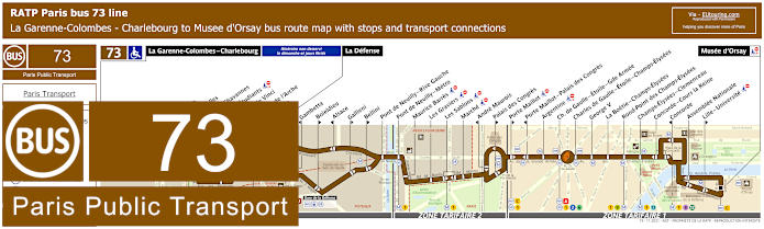
RATP Paris bus line 73 with stops, connections and street plan
Although here you have the bus line 73 maps and timetables showing the route travelling from Musee d'Orsay to La Garenne-Colombes - Charlebourg on a Monday to Saturday except for French National holidays, yet on a Sunday and holidays the terminus is La Defense, which is how to get to the Grande Arche, but for the convention centre you would need the bus stop Palais des Congres in one direction or Porte Maillot - Palais des Congres in the other heading into Paris, both of which are very close to this event venue.
Paris bus line 73 stops:
La Garenne-Colombes - Charlebourg***, Nordmann***, Les Fauvelles***, Puvis de Chavannes***, Rue des Etudiants***, Leonardo de Vinci***, Faubourg de l’Arche** ***, Caron***, La Defense, Gambetta*, Boieldieu**, Alsace*, Gallieni**, Bellini**, Pont de Neuilly - Rive Gauche, Pont de Neuilly, Les Graviers, Rue de l’Hotel de Ville, Les Sablons, Marche, Montrosier*, Andre Maurois**, Palais des Congres**, Porte Maillot**, Porte Maillot - Palais des Congres*, Argentine, Charles de Gaulle - Etoile - Gde Armee, Charles de Gaulle - Etoile - Champs-Elysees, George V, La Boetie - Champs-Elysees, Rond-Point des Champs-Elysees, Champs-Elysees - Clemenceau, Concorde - Cours la Reine, Concorde*, Assemblee Nationale, Lille - Universite**, Musee d'Orsay.
* Stop served in direction of La Garenne-Colombes - Charlebourg or La Defense. ** Stop served in direction of Musee d'Orsay. *** Not served on a Sunday or French holidays.
Paris bus line 73 main transport connections:
Metro Lines: 1, 2, 6, 8, 9, 12, 13. Train Lines: A, C, L, U. Tram Line: T2.
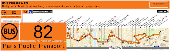
RATP Paris bus line 82 with stops, connections and street plan
Travelling from Neuilly - Hopital Americain to Luxembourg by the beautiful Luxembourg Gardens, the Paris bus line 82 has the bus stops of Palais des Congres in one direction or the Porte Maillot stop going in both directions, with this particular bus stop being located on the Avenue de Malakoff only around 400 metres from this event venue and convention centre.
Paris bus line 82 stops:
Neuilly - Hopital Americain, Bineau - La Saussaye*, Bineau - Chateau**, Perronet, La Saussaye - D'Argenson*, Chateau, General Gouraud, Rue de l'Eglise**, Sainte-Foy, Eglise Saint-Pierre, Chartres, Montrosier - Parmentier, Andre Maurois**, Palais des Congres**, Porte Maillot - Pershing*, Porte Maillot, Alphand, Foch, Victor Hugo - Poincare, Lauriston*, Kleber - Boissiere, Lubeck, Iena, Varsovie, Tour Eiffel, Champ de Mars, Champ de Mars - Suffren, General Detrie, General de Bollardiere, Ecole Militaire, Vauban - Hotel des Invalides, Saint-Francois-Xabier, Oudinot, Duroc, Maine - Vaugirard, Montparnasse - Alencon, Montparnasse**, Montparnasse - Cinemas*, Notre-Dame des Champs**, Vavin, Brea - Notre-Dame des Champs*, Assas - Duguay-Trouin**, Guynemer - Vavin, Campagne - Port Royal, Observatoire - Port Royal, Val de Grace, Auguste Comte, Luxembourg.
* Stop served in direction of Neuilly - Hopital Americain. ** Stop served in direction of Luxembourg.
Paris bus line 82 main transport connections:
Metro Lines: 1, 2, 4, 6, 8, 9, 10, 12, 13. Train Lines: B, C, N.
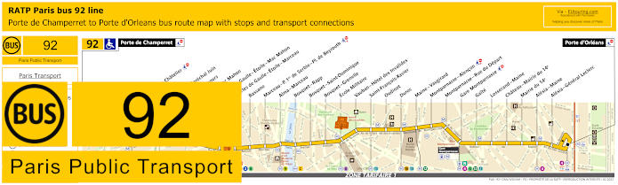
RATP Paris bus line 92 with stops, connections and street plan
The Paris bus line 92 with its various transport connections on route, goes between Porte de Champerret and Porte d'Orleans and as you can see from the maps and timetables, there are two bus stops either side of the Arc de Triomphe called the Charles de Gaulle - Etoile - Mac Mahon and Charles de Gaulle - Etoile - Marceau that will get you within around 1150 metres of Palais des Congres by walking along the Avenue de la Grande-Armee.
Paris bus line 92 stops:
Porte de Champerret, Pereire - Le Chatelier*, Pereire*, Pereire - Marechal Juin, Pierre Demours, Ternes - Mac Mahon, Charles de Gaulle - Etoile - Mac Mahon, Charles de Gaulle - Etoile - Marceau, Bassano, Marceau - P. 1er de Serbie - Pl. de Beyrouth, Alma - Marceau, Bosquet - Rapp, Bosquet - Saint-Dominique, Bosquet - Grenelle, Ecole Militaire, Vauban - Hotel des Invalides, Saint-Francois-Xavier, Oudinot, Duroc, Maine - Vaugirard, Montparnasse - Alencon, Montparnasse - Rue du Depart, Gare Montparnasse, Gaite, Losserand - Maine, Chateau - Mairie du 14e, Mairie du 14e, Alesia - Maine, Alesia - General Leclerc, Porte d'Orleans.
* A direction dependant stop.
Paris bus line 92 main transport connections:
Metro Lines: 1, 2, 3, 4, 6, 8, 9, 10, 12, 13. Train Lines: A, C, N. Tram Line: T3a.
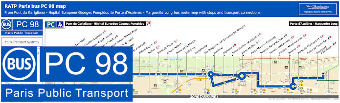
RATP Paris PC bus line 98 stops, connections and street plan
Yet the bus route PC, also known as RATP bus line 98 is one of the closest bus stops to the Palais des Congres at only a few metres walk from the entrance, and travelling between the outskirts of Paris between Pont du Garigliano - Hopital Europeen Georges Pompidou and Porte d'Asnieres - Marguerite Long, please take note of the maps and timetables, as two of the bus stops for this events venue and convention centre only travel in a specific direction.
Paris PC bus line 98 stops:
Pont du Garigliano - Hopital Europeen Georges Pompidou, Versailles - Exelmans, Versailles - Chardon-Lagache, Porte de Saint-Cloud - Murat, Porte de Saint-Cloud*, Porte de Saint-Cloud - Michel Ange, Lycee Claude Bernard, Porte Molitor, Porte d'Auteuil, Alfred Capus, Raffet, Porte de Passy, Ernest Hebert, Porte de la Muette, Dufrenoy, Longchamp, Pte Dauphine - Mal De Lattre de Tassigny, Marbeau*, Alphand**, Porte Maillot - Malakoff*, Porte Maillot**, Porte Maillot - Pershing, Pereire - Porte Maillot, Ternes - Mac Mahon, Pereire - Marechal Juin*, Pereire**, Porte de Champerret, Porte de Courcelles, Gourgaud - Paul Adam, Porte d'Asnieres - Marguerite Long.
* Stop served in direction of Pont du Garigliano - Hopital Europeen Georges Pompidou. ** Stop served in direction of Porte d'Asnieres - Marguerite Long.
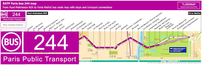
RATP Paris bus line 244 with stops, connections and street plan
As you can see from the maps and timetables, the bus route 244 travels from the Paris region at Rueil-Malmaison RER in the ticket tariff zone 3 through to Porte Maillot on the edge of the Bois de Bolougne with its various tourist attractions like getting to the Hippodrome de Longchamp horse racing course or Fondation Louis Vuitton, and it is the Porte Maillot bus stop you would need for the Palais des Congres.
Paris bus line 244 stops:
Rueil-Malmaison RER, Colmar*, Les Martinets**, Baudin*, Genevieve Couturier**, Albert 1er - Rueil - Ville*, Rueil - Ville, Le Gue, Hopital Stell, Edmond Rostand, Les Godardes, Rue de la Paix, 8 Mai 1945, Les Houtraits, Place de la Paix, Place Jean Jaures, Croix du Roy, Val d'Or, Garibaldi, Suresnes - Longchamp, De Gaulle, Rue des Bourets - Pont de Suresnes, Les Moulins - Camping, Longchamp - GoodPlanet, Bagatelle - Pre Catelan, Route des Lacs***, Route de La Muette***, Porte de Madrid****, Fondation Louis Vuitton****, Jardin d'Acclimatation, Porte Maillot.
* Stop served in direction of Rueil-Malmaison RER. ** Stop served in direction of Porte Maillot. *** Served on a Monday to Friday. **** Served on Saturday, Sunday and French public holidays.
Paris bus line 244 main transport connections:
Metro Line: 1. Train Lines: A, C. Tram Line: T2. Bus Lines: 4E, 27, 40, 70, 73, 82, 93, 144, 158, 160, 241, 258, 259, 360, 367, 467, PC (98).
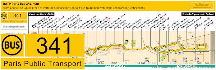
RATP Paris bus line 341 with stops, connections and street plan
Going from Porte de Clignancourt - Croisset the Paris bus line 341 travels to Charles de Gaulle - Etoile, which is the bus stop you would need for the Palais des Congres by walking from here by the Arc de Triomphe along the Avenue de la Grande Armee, yet as you can see from the maps and timetables, many stops are only served in a particular direction, so please be aware of this.
Paris bus line 341 stops:
Charles de Gaulle - Etoile, Charles de Gaulle Etoile - Mac Mahon, Ternes–Mac Mahon, Pierre Demours, Pereire - Marechal Juin, Pereire**, Pereire - Le Chatelier*, Gourgaud - Paul Adam*, Porte d’Asnieres Marguerite Long, Alsace, Gare de Clichy - Levallois, Chance - Milly, Jaures - Barbusse, Barbusse - Martre**, Landy - Martre, Bateliers**, Villeneuve - General Leclerc*, Hopital Beaujon, Claude Debussy, Rue Pierre, Cimetiere, Fondation Roguet, Citroen**, Georges Boisseau, Victor Hugo - Sanzillon, Clichy - Saint-Ouen RER, Camille Claudel, Touzet - Gaillard, Floreal**, Colisee*, Bois Le Pretre**, Epinettes - Pouchet**, Toulouse-Lautrec*, Porte de St-Ouen, Angelique Compoint, Porte de Clignancourt, Poissonniers - Cocteau**, Porte de Clignancourt - Croisset.
* Stop served in direction of Charles de Gaulle Etoile. ** Stop served in direction of Porte de Clignancourt Croisset.
Paris bus line 341 main transport connections:
Metro Lines: 1, 2, 3, 4, 6, 13, 14. Train Lines: A, C, L. Tram Line: T3b. Bus Lines: 20, 21, 22, 30, 31, 52, 54, 56, 66, 73, 74, 84, 85, 92, 93, 94, 98 (PC), 137, 138, 140, 163, 166, 173, 174, 244, 255, 274, 340, La Traverse (513), TUC Est (574), TUC Ouest (574).
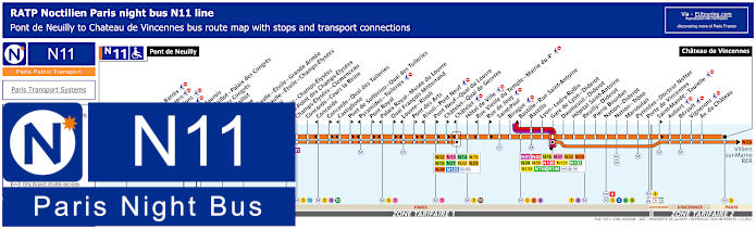
Paris Noctilien night bus N11 map with stops and transport connections
The Noctilien is a Paris night bus service that operates during the early hours from around 12:30am to 5:30am when other Paris transport has finished for the night, so here you can see the Noctilien N11 night bus line going from Pont de Neuilly to Chateau de Vincennes stopping at transport hubs such as Chatelet and Gare de Lyon - Diderot. Yet for the events venue and convention centre you would need either the Palais des Congres bus stop or the Porte Maillot - Palais des Congres stop depending on which way you wish to travel.
Paris night bus line N11 stops:
Pont de Neuilly, Maurice Barres, Les Graviers, Les Sablons, Marche, Andre Maurois*, Porte Maillot - Palais des Congres*, Palais des Congres**, Porte Maillot**, Argentine, Charles de Gaulle - Etoile - Grande Armee, Charles de Gaulle - Etoile - Champs-Elysees, George V, La Boetie - Champs-Elysees, Rond-Point des Champs-Elysees, Champs-Elysees - Clemenceau, Concorde - Cours la Reine, Concorde*, Concorde - Quai des Tuileries**, Castiglione*, Pont de Solferino - Quai des Tuileries**, Pyramides - Tuileries*, Pont Royal**, Palais Royal - Musee du Louvre*, Quai Francois Mitterrand**, Louvre - Rivoli*, Pont des Arts**, Rivoli - Pont Neuf*, Pont Neuf - Quai du Louvre**, Chatelet - Quai de Gesvres**, Chatelet*, Hotel de Ville, Rue Vieille du Temple - Mairie du 4e*, Rue de Jouy**, Saint-Paul, Birague, Bastille - Rue Saint-Antoine, Bastille, Lyon - Ledru-Rollin, Gare de Lyon - Diderot, Daumesnil - Diderot, Hopital Saint-Antoine, Reuilly - Diderot, Pierre Bourdan, Nation - Diderot, Nation - Trone, Marsoulan, Pyrenees - Docteur Netter, Porte de Vincennes, Saint-Mande - Tourelle**, Aubert, Berault, Vignerons, Avenue du Chateau, Chateau de Vincennes.
* In direction of Pont de Neuilly. ** In direction of Chateau de Vincennes.
Paris night bus line N11 main transport connections:
Paris Noctilien night bus N24 map with stops and transport connections
Just like the Noctilien bus route above, for the Noctilien line N24 you would again need either the Palais des Congres or Porte Maillot - Palais des Congres night bus stops depending upon whether you are travelling towards the terminus of Chatelet or Sartrouville RER in the opposite direction, as you can see from the N24 maps and timetables, also showing other transport connections as well.
Paris night bus line N24 stops:
Satrouville RER, Poste, Stalingrad, Jean Mermoz, Voltaire, Edouard Vaillant, Eglise, Picardie, Charles de Gaulle, Quatre Chemins, Rue de Chatou, Clemenceau, Condorcet, Val Notre-Dame, La Berthie, Albert 1er, Place des Droits de l'Homme, La Grace de Dieu, Pont de Bezons, Parc Pierre Lagravere, Victor Basch, Jacqueline Auriol, Gare de La Garenne-Colombes, La Garenne-Colombes - Charlebourg, Nordmann, Les Fauvelles, Dieppe, Faubourg de l'Arche, Caron, La Defense, Boieldieu**, Gallieni**, Gambetta*, Bellini**, Alsace*, Pont de Neuilly - Rive Gauche, Pont de Neuilly - Metro, Maurice Barres, Les Graviers, Les Sablons, Marche, Andre Maurois*, Porte Maillot - Palais de Congres*, Palais de Congres**, Porte Maillot**, Argentine, Charles de Gaulle - Etoile - Grande Armee, Charles de Gaulle - Etoile - Champs-Elysees, George V, La Boetie - Champs-Elysees, Rond-Point des Champs-Elysees, Champs-Elysees - Clemenceau, Concorde - Cours la Reine, Concorde*, Concorde - Quai des Tuileries**, Castiglione*, Pont de Solferino - Quai des Tuileries**, Pyramides - Tuileries*, Pont Royal**, Palais Royal - Musee du Louvre*, Quai Francois Mitterrand**, Pont des Arts**, Louvre - Rivoli*, Rivoli - Pont Neuf*, Pont Neuf - Quai du Louvre**, Chatelet - Quai de Gesvres**, Chatelet.
* Stop served in direction of Sartrouville RER. ** Stop served in direction of Chatelet.
Paris night bus line N24 main transport connections:
Metro Lines: 1, 2, 4, 6, 7, 8, 9, 11, 12, 14. Train Lines: A, B, C, D, J, L, U. Tram Line: T2. Bus Lines: N01, N02, N11, N12, N13, N14, N15, N16, N21, N22, N23, N122, N153.
Paris Noctilien night bus N53 map with stops and transport connections
Here you have the Noctilien line N53 night bus that travels from Nanterre - Anatole France to Gare Saint-Lazare train station, yet when it comes to reaching or leaving the convention centre and events venue of Palais des Congres, you would need either the Ch. de Gaulle - Etoile - Kleber or Ch. de Gaulle - Etoile - Friedland night bus stops by the Arc de Triomphe and the Tomb of the Unknown Soldier.
Paris night bus line N53 stops:
Nanterre - Anatole France, Nanterre - Universite RER, Soufflot, Prefecture des Hauts-de-Seine, Nanterre - Prefecture RER, Esplanade Charles de Gaulle, Prefecture des Hauts-de-Seine, Joliot-Curie - Courbevoie, Palais des Sports, Mairie de Nanterre, Sadi Carnot - Joliot-Curie, Place de la Boule - Joliot-Curie, Place de la Boule - Joffre, Sainte-Genevieve, Boulevard National, Gabriel Peri, Le Gue, Hopital Stell, Place Richelieu, Zurich, Place Besche, Dunant, Lieutenant-Colonel de Montbrison, Place de la Paix, Place Jean Jaures, Croix du Roy, Val d’Or, Garibaldi, Longchamp, De Gaulle, Rue des Bourets - Pont de Suresnes, Les Moulins - Camping, La Muette - Boulainvilliers, Place Possoz, Scheffer, Trocadero, Kleber - Paul Valery, Charles de Gaulle - Etoile - Kleber, Charles de Gaulle - Etoile - Friedland, Balzac, Haussmann - Miromesnil, Saint-Augustin, Saint-Augustin - La Boetie, Pasquier - Anjou, Gare Saint-Lazare.
Paris night bus line N53 main transport connections:
Metro Lines: 1, 2, 3, 6, 9, 12, 13, 14. Train Lines: A, E, J, L. Bus lines: N01, N02, N11, N15, N16, N24, N51, N52, N150, N151, N152, N153, N154.
Paris Noctilien night bus N151 map with stops and transport connections
Whereas this shows the bus maps and timetables for the Paris Noctilien N151 bus route that travels between Gare Saint-Lazare and Gare de Mantes La Jolie with night bus stops at many train stations including the Porte Maillot - RER stop on the Avenue de la Grande Armee for the Palais des Congres.
Paris night bus line N151 stops:
Gare St-Lazare - Cour de Rome, Charles de Gaulle - Friedland - Avenue de Friedland, Porte Maillot - RER - Avenue de la Grande Armee, Orgeval Novotel Pont A13*, Gare de Villennes-sur-Seine - Place de la Liberation, Gare de Poissy - Rue Maurice Berteaux, Carrieres-sous-Poissy - Avenue de l'Europe**, Triel-sur-Seine - Rue Eugene Senet - Pont du Triel, Gare de Vernouillet Verneuil - Gare Routiere, Verneuil La Faisanderie - Boulevard Andre Malraux, Gare des Clairieres de Verneuil - Place de la Resistance, Gare des Mureaux - Place du 8 Mai 1945 - Gare Routiere, Les Mureaux Sablons - Avenue de l'Europe, Gare de Mantes Station - Boulevard Calmette - Place de l'Europe, Gare de Mantes-La-Jolie - Place du 8 Mai 1945.
* Night bus served in direction of Gare de Mantes La Jolie. ** Night buses at this stop served in direction of Gare St-Lazare are not suitable for the disabled and wheelchair users.
Paris night bus line N151 main transport connections:
Metro Lines: 3, 9, 12, 13, 14. Train lines: E, J, L. Bus Lines: N01, N02, N11, N15, N16, N24, N51, N52, N53, N150, N152, N153, N154.
Paris Noctilien night bus N153 map with stops and transport connections
With very few night bus stops in between the Noctilien line N153 travels from Gare Saint-Lazare to Saint-Germain-en-Laye RER, and as you can see from the night bus maps and timetables, there is the Porte Maillot - Palais des Congres stop and the Porte Maillot stop depending whether you are travelling into Paris or to the outskirts of the Paris region.
Paris night bus line N153 stops:
Saint-Germain-en-Laye RER*, Le Vesinet - Le Pecq RER, Hotel de Ville - Le Vesinet Centre RER, Mairie - Chatou - Croissy RER, Rueil-Malmaison RER, Jules Quentin - Nanterre - Ville RER, Pont de Neuilly*, Porte Maillot - Palais des Congres**, Porte Maillot**, Charles de Gaulle - Etoile - Friedland*, Gare Saint-Lazare*.
* Different start times depending upon your stop and what night of the week. ** Stop only served in a specific direction.
Paris night bus line N153 main transport connections:
Metro Lines: 1, 2, 3, 6, 9, 12, 13, 14. Train Lines: A, C, E, J, L. Tram Line: T13 Bus Lines: N01, N02, N11, N15, N16, N24, N51, N52, N53, N150, N151, N152, N154.
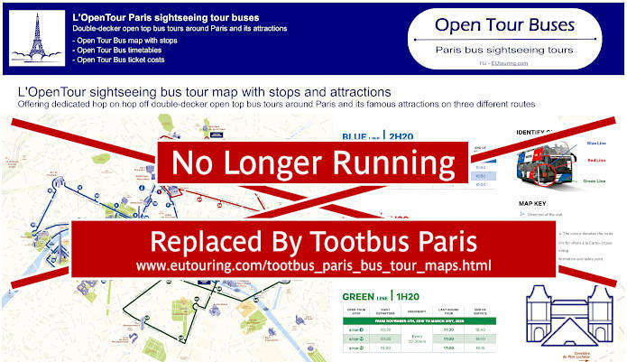
Paris Open Tour bus sightseeing tour map for Blue, Red and Green bus lines with stops and timetables
For those of you attending a convention at Palais des Congres, perhaps you will have time to discover Paris, and one of the ways of getting to see many of the tourist attractions around the city is with Open Tour, which is a hop on and hop off sightseeing bus tour company. With numerous stops at strategic locations, you would need the Blue Line and stop 12 called the Champs-Elysees - Open Tour Kiosque stop located at 125 Avenue des Champs Elysees, 75008 on the famous avenue close by the Arc de Triomphe, which is approximately 1250 metres walk from Palais des Congres events venue.
1: Haussman - Opera - Visitor centre - 13 Rue Auber, 75009 2: Opera - 4 Septembre - 49 Avenue de l'Opera, 75002 3: Palais-Royal - Comedie Francaise - 3 Avenue de l'Opera, 75002 4: Musee du Louvre - Place du Carrousel, 75001 5: Pont Neuf - Quai des Orfevres - Face au 64 Quai des Orfevres, 75001 6: Notre-Dame - Visitor Centre - 4 Rue du Petit Pont, 75005 7: Musee d'Orsay - 8 Quai Anatole France, 75007 8: Concorde - 12 Place de la Concorde, 75008 9: Champs-Elysees - Grand Palais - 14 Avenue des Champs-Elysees, 75008 10: Champs-Elysees - Disney Store - 60 Avenue des Champs-Elysees, 75008 11: Champs-Elysees - George V - 116 Avenue des Champs-Elysees, 75008 12: Champs-Elysees - Open Tour Kiosque - 125 Avenue des Champs-Elysees, 75008 13: Trocadero - Avenue du President Wilson, 75016 14: Tour Eiffel - 69 Quai Branly, 75007 15: Pont de l'Alma - 87 Quai Branly, 75007 16: Pont Alexandre III - Invalides - 41 Quai d'Orsay, 75007 17: Concorde-Royale - 4 Rue Royale, 75008 18: Madeleine - 18 Place de la Madeleine, 75008
Paris Open Tour bus sightseeing tour maps with stops and timetables:
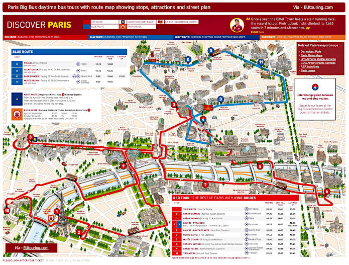
Big Bus Paris sightseeing tour map for Red and Blue bus lines with stops and timetables
Alternatively, you have the Big Bus Paris sightseeing tour company that also offers a hop on and hop off bus tour service, with the stop you would need being on the Red Route and stop 8, which is called the Champs-Elysees stop at 156 Avenue des Champs-Elysees that facing the Arc de Triomphe by Rue de Tilsitt at about 1200 metres from Palais des Congres.
1: Tour Eiffel - Quai Branly, Entree 2 Tour Eiffel 2: Champ de Mars - Avenue Joseph Bouvard 3: Opera Garnier - Facing 15 Rue Scribe (next to the RoissyBus airport shuttle bus stop) 4: Louvre - Pyramide / Big Bus Information Centre - 11 Avenue de l’Opera (by Big Bus information center) 5: Louvre - Pont des Arts - Quai Francois Mitterrand (near Pont des Arts) 6: Notre Dame - 3 Rue Lagrange (outside souvenir shop, opposite Square Rene Viviani) 7: Musee d'Orsay - 58 Place Henry de Montherlant (facing the museum by Quai Anatole France) 8: Champs-Elysees - 156 Avenue des Champs-Elysees (facing the Arc de Triomphe by Rue de Tilsitt) 9: Grand Palais - Avenue Winston Churchill (facing the Grand Palais and Petit Palais) 10: Trocadero - Avenue Paul Doumer (next to the Palais de Chaillot close to the Statue of Benjamin Franklin)
Big Bus Paris daytime sightseeing tour maps with stops and timetables:
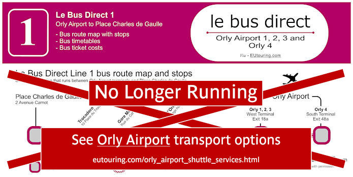
Le Bus Direct 1 Orly Airport to Place de Charles de Gaulle map with stops, timetables and ticket information
When it comes to getting from Paris Orly Airport to Palais des Congres, you will be pleased to know that there is a dedicated airport shuttle bus service with Le Bus Direct, which is Route 1 that goes to both terminals of Orly 1-2-3 and Orly 4, and Le Bus Direct 1 has a stop called Etoile / Champs Elysees at 2 Avenue Carnot, which is the road next to the Avenue de la Grande-Armee around the Arc de Triomphe intersection, and at Orly Airport the stop is on Level O Arrivals, Gate D, Platform 1.
Le Bus Direct 1 stops:
Orly 4 (south terminal), Orly 1 2 3 (west terminal), Porte d'Orleans, Gare Montparnasse, Trocadero, Place Charles de Gaulle.
Le Bus Direct 1 ticket pricing:
Adult ticket €12.00 one way or €20.00 return Child ticket (aged 4-11 years) €7.00 one way or €14.00 return Group (discount for +3 people) €9.00 pp one way or €18.00 pp return pricing is per person
Download Le Bus Direct 1 route map, timetables and ticket info:
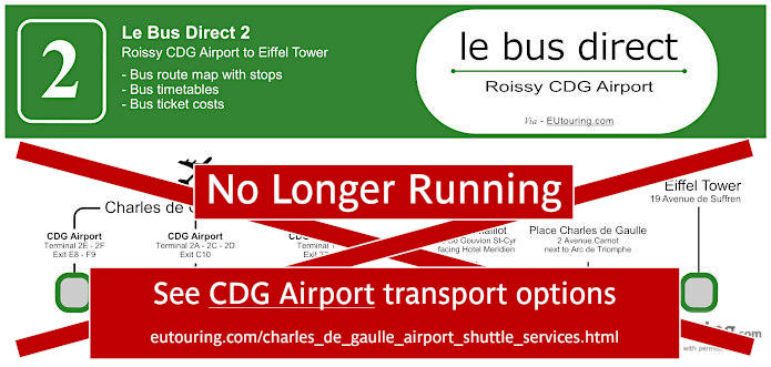
Le Bus Direct 2 Charles de Gaulle Airport to Eiffel Tower map with stops, timetables and ticket information
Yet Le Bus Direct also offers a dedicated airport shuttle bus service from Charles de Gaulle Airport to Palais des Congres and classed as Le Bus Direct 2 or Route 2, this stops right by the Porte Maillot making it very easy to get to or from this events venue and conference centre.
When coming from CDG Airport Terminal 1 you would need Gate 32, from Terminals 2E and 2F you would need Gate E8 and from CDG Terminals 2A and 2C you will find a waiting hall and the platform for Line 2.
Now normally the bus stop at Porte Maillot would be at 66 Boulevard Gouvion-Saint-Cyr, to the right of the Palais des Congres as you are looking at the map, yet this has temporarily moved to 23-27 Boulevard Pershing on the opposite side, meaning you can walk round or through the building to access this.
Le Bus Direct 2 stops:
CDG Airport Terminal 2E 2F, CDG Airport Terminal 2A 2C 2D, CDG Airport Terminal 1, Porte Maillot, Place de Charles de Gaulle, Eiffel Tower.
Le Bus Direct 2 ticket pricing:
Adult ticket €18.00 one way or €31.00 return Child ticket (aged 4-11 years) €10.00 one way or €20.00 return Group (discount for +3 people) €13.00 pp one way or €26.00 pp return pricing is per person
Download Le Bus Direct 2 route map, timetables and ticket info: