How to get to Orly Airport in Paris using public transport
Below are the Orly Airport transport options showing how to get to Orly Airport with route maps, stops, connections, street plans and timetables along with plans for airport parking, drop-off points and the Orly airport terminal plans with information on the services, shops plus much more, which are all available in PDF and image file formats, as well as in large or small file sizes, making these ideal for download to any mobile device or computer system.
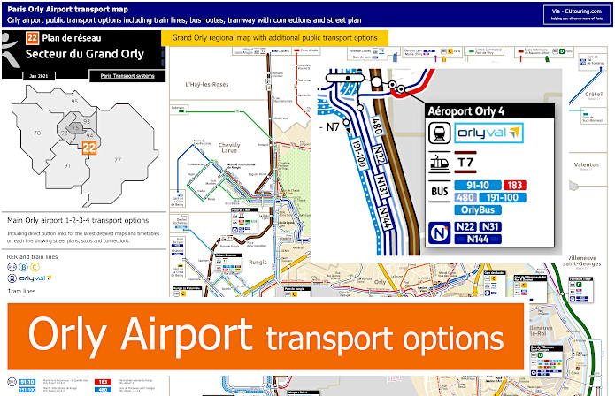
Orly Airport transport map with train lines, tramway, bus routes, shuttle services, connections and street plan
Here you can see a street plan with the different transport options for Orly Airport Terminals 1,2,3 and Orly Terminal 4, which used to be known as Orly West and Orly Sud, and as you can see from the maps, this shows the RER trains and train stations within the area, plus tram lines, buses, night buses and shuttle buses that will get you to Paris.
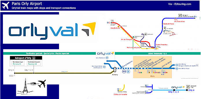
OrlyVal train map for Orly airport to the RER B line with connections and stops
Above are the OrlyVal train maps, and this is a shuttle service that links the RER B line at the station called Antony directly to Orly Airport terminals 1,2,3 and 4, which runs daily from 6am through to 11:30pm at approximately 5 to 8 minute intervals depending upon the time, like during rush hour. So as you will see from the maps, if going from Paris to Orly Airport you would need the direction of Saint-Remy-les-Chevreuse on the RER B4 branch to reach Antony station and the OrlyVal shuttle service.
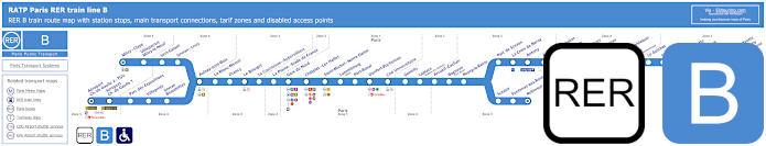
Blue RER B train line map showing station stops, line branches, transport connections and zones
These maps show the RER B train line, which has a connection at Antony for the OrlyVal train that then goes to the Orly Airport terminals, yet as you can see, this is also a transport option that will not just get you to Paris but also attractions like Parc de Sceaux and Stade de France. In addition, the RER B line can also be an airport transfer option between Orly Airport and Charles de Gaulle Airport.
Paris RER B train line stops:
Mitry–Claye*, Villeparisis - Mitry-le-Neuf, Vert-Galant, Sevran–Livry, Aulnay-sous-Bois, Le Blanc-Mesnil, Drancy, Le Bourget, La Courneuve - Aubervilliers, La Plaine - Stade de France, Gare du Nord, Chatelet - Les Halles, Saint-Michel - Notre-Dame, Luxembourg, Port-Royal, Denfert-Rochereau, Cite Universitaire, Gentilly, Laplace, Arcueil - Cachan, Bagneux, Bourg-la-Reine, Sceaux, Fontenay-aux-Roses, Robinson*, Aeroport Charles de Gaulle 2 - TGV*, Aeroport Charles de Gaulle 1, Parc des Expositions, Villepinte, Sevran - Beaudottes, Parc de Sceaux, La Croix de Berny, Antony (Orly), Fontaine-Michalon, Les Baconnets, Massy - Verrieres, Massy - Palaiseau, Palaiseau, Palaiseau - Villebon, Lozere (Ecole Polytechnique), Le Guichet, Orsay–Ville, Bures-sur-Yvette, La Hacquiniere, Gif-sur-Yvette, Courcelle-sur-Yvette, Saint-Remy-les-Chevreuse*.
* Terminus Points.
Paris RER B train line main transport connections:
Metro Lines: 1, 2, 4, 5, 6, 7, 10, 11, 14. Train Lines: A, C, D, E, H, K, TGV. Tram Lines: T3a, T4, T11. Bus Lines: TVM (14), CDG Val, OrlyBus, OrlyVal, RoissyBus.
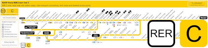
Yellow RER C train line map showing station stops, line branches, transport connections and zones
Whereas here is the RER C line, which has several different branches reaching destinations like Chateau Versailles Rive Gauche and when travelling by train from Paris to Orly Airport you could utilise the RER C by heading in the direction of Massy Palaiseu, yet disembarking at the Pont de Rungis stop, the maps show a connection for Aeroport d'Orly, which is utilising the Go C shuttle bus service.
Paris RER C train line stops:
Pontoise*, St-Ouen l'Aumone, St-Ouen l'Aumone - Liesse, Pierrelaye, Montigny Beauchamp, Francoville - Le Plessis-Bouchard, Cernay, Ermont Eaubonne, St-Gratien, Epinay-sur-Seine, Gennevilliers, Les Gresillons, St-Ouen, Porte de Clichy, Pereire Levallois, Neuilly - Porte Maillot (Palais des Congres), Avenue Foch, Avenue Henri Martin, Boulainvilliers, Avenue du Pdt Kennedy (Maison de Radio France), Champ de Mars (Tour Eiffel), Pont d'Iena, Invalides, Musee d'Orsay, St-Michel (Notre Dame), Paris Gare d'Austerlitz, Bibliotheque Francois Mitterrand, Ivry-sur-Seine, Vitry-sur-Seine, Les Ardoines, Choisy le Roi, Villeneuve le Roi, Ablon, Athis Mons, Juvisy, Savigny-sur-Orge, Epinay-sur-Orge, Ste-Genevieve des Bois, St-Michel-sur Orge, Bretigny, Marolles en Hurepoix, Bouray, Lardy, Chamarande, Etrechy, Etampes, St-Martin d'Etampes*, Versailles Chateau Rive Gauche*, Porchefontaine, Viroflay Rive Gauche, Chaville - Velizy, Meudon - Val Fleury, Issy, Issy - Val de Seine, Pont du Garigliano (Hopital Europeen Georges Pompidou), Javel, St-Quentin en Yvelines*, St-Cyr, Versailles Chantiers**, Petit Jouy les Loges, Jouy en Josas, Vauboyen, Bievres, Igny, Massy Palaiseau**, Massy Verrieres, Chemin d'Antony, Rungis La Fraternelle, Pont de Rungis (Aeroport d'Orly), Orly Ville, Les Saules, Longjumeau, Chilly Mazarin, Gravigny Balizy, Petit Vaux, La Norville (St-Germain les Arpajon), Arpajon, Egly, Breuillet (Bruyeres le Chatel), St-Cheron, Sermaise, Dourdan, Dourdan la Foret*.
* Terminus Points. ** RER C Transfer Points.
Paris RER C train line main transport connections:
Metro Lines: 1, 2, 3, 4, 5, 6, 8, 9, 10, 12, 13, 14. Train Lines: B, D, H, J, N, U, TGV, TER. Tram Lines: T1, T2, T3a, T3b, T6, T7, T8, T9, T11, T13. Bus Lines: 183, 393, PC (98), TVM (14).
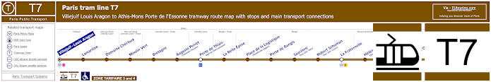
Paris tram line T7 map with tramway stations, transport connections and zones
The Tram Line T7 to Orly Airport goes from Villejuif - Louis Aragon through to Athis-Mons - Porte de l'Essone every day of the year, and as you will see from the maps and timetables there is a tramway stop called Aeroport d'Orly on the Rue du Musee, which is located by Airport Terminal 4, although if you need Terminals 1,2,3 you can then use the airport terminal shuttle service.
Paris tram line T7 stops:
Villejuif - Louis Aragon, Lamartine, Domaine Cherioux, Moulin Vert, Bretagne, Auguste Perret (Cimetiere Parisien), Porte de Thiais (Marche International), La Belle Epine, Place de la Logistique (Plateforme Sogaris), Porte de Rungis, Saarinen (Parc Silic Nord), Robert Schuman (Parc Silic Centre), La Fraternelle, Helene Boucher (Orlytech), Caroline Aigle (Orlyfret), Coeur d'Orly, Aeroport d'Orly, Athis-Mons - Porte de l'Essonne.
Paris tram line T7 main transport connections:
Metro Line: 7. Train Lines: C, OrlyVal. Bus Line: OrlyBus.
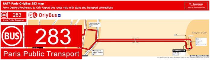
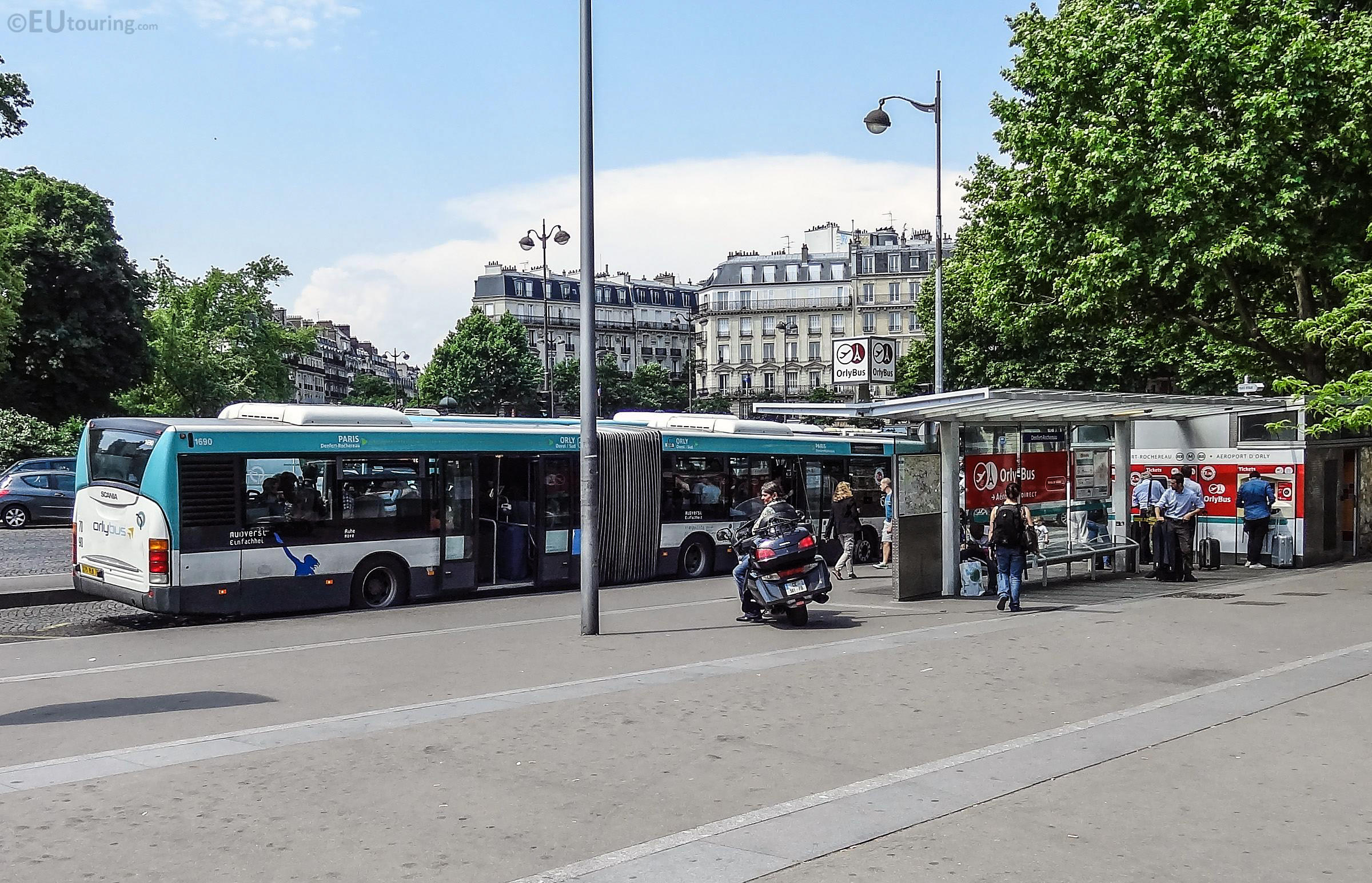
Paris Orlybus line 283 with stops, connections and street plan
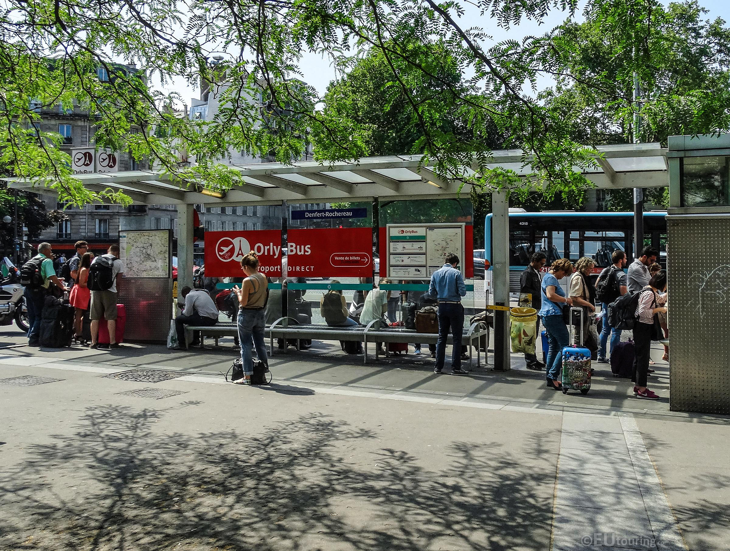
Here is another dedicated airport shuttle bus service called OrlyBus, which travels from the train station and ticket office at Denfert-Rochereau in Paris stopping at Stade Charlety and going on to Aeroport d'Orly 1-2-3 and Aeroport d'Orly 4, yet as you can see from the maps and timetables, on the Orly Airport to Paris, Denfert-Rochereau journey, the RATP OrlyBus shuttle bus has a stop at Montsouris - Tombe Issoire and rather than OrlyBus, this service is also sometimes referred to as RATP bus line 283.
Paris Denfert-Rochereau, Stade Charlety - Porte de Gentilly, Aeroport d'Orly 1-2-3, Aeroport d'Orly 4, Montsouris - Tombe Issoire.
Paris Orlybus line 283 main transport connections:
Metro Lines: 4, 6. Train Lines: B, OrlyVal. Tram Lines: T3a, T7. Bus Lines: 8, 91-10, 183, 191-100, Bus Direct 1, Bus Direct 3, Go C Paris, Magical Shuttle, N22, N31, N131, N144.
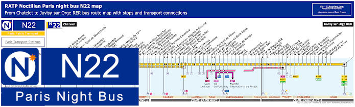
Paris Noctilien night bus N22 map with stops and transport connections
So here we have the Noctilien bus line N22 that shows the maps and timetables for the night bus route going from the major transport hub of Chatelet to Juvisy-sur-Orge RER, therefore if you want to go from Paris to Orly Airport when other public transport is not running you have that option with the RATP N22 bus route as it has one of the bus stops at Orly 4, formerly known as Orly Sud until 2019.
Paris night bus line N22 stops:
Chatelet, Cite - Parvis Notre Dame*, Cite - Palais de Justice**, Petit Pont*, Notre-Dame - Quai de Montebello**, Dante*, Lagrange**, Maubert - Mutualite, Cardinal Lemoine, Monge, Censier - Daubenton, Monge - Claude Bernard, Les Gobelins, Banquier, Place d'Italie - Mairie du 13eme, Place d'Italie - Italie 2, Vandrezanne, Italie - Tolbiac, Maison Blanche, Porte d'Italie, Porte d'Italie - Helene Boucher, Roger Salengro - Fontainebleau, Convention - Fontainebleau, Le Kremlin-Bicetre Metro, Dauphin - Anatole France, Henri Barbusse, Dispensaire Danielle Casanova, Jean Jaures*, Paul Vaillant-Couturier - Hopital P. Brousse**, Guynemer - Place des Fusilles*, Gynemer - Maxime Gorki, Gynemer - Place des Fusilles**, Villejuif - Louis Aragon, Lamartine, Domaine Cherioux, Ecole Departmentale**, Moulin Vert, Bretagne, Cimetiere Parisien de Thiais, Auguste Perret*, Le Cor de Chasse - La Belle Epine**, Le Cor de Chasse, Porte de Thiais, Marche International de Rungis, Trois Marches, Maree, Viaduc, Agen, Chateaurenard, Rue de la Bresse, Belle Epine Sud, SENIA, Pont de Rungis RER**, Pont de Rungis*, Hangar No 6, Caroline Aigle, Coeur d'Orly, Aeroport d'Orly 4, Aeroport d'Orly*, Porte de l'Essonne, Aristide Briand, Belle Etoile, Marx Dormoy, Marche des Gravilliers, Pyramide de Juvisy, Observatoire C. Flammarion, Mairie de Juvisy, Piver, Hopital de Juvisy**, Marche de Juvisy, Juvisy-sur-Orge RER.
* Served in the direction of Juvisy-sur-Orge RER. ** Served in the direction of Chatelet.
Paris night bus line N22 main transport connections:
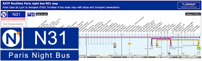
Paris Noctilien night bus N31 map with stops and transport connections
Whereas the Noctilien night bus N31 goes from Paris at Gare de Lyon to Aeroport d'Orly - Terminal 4, yet you can also catch this bus route at train stations such as Gare d'Austerlitz along with many other bus stops that have transport connections to other Noctilien lines.
Paris night bus line N31 stops:
Gare de Lyon, Gare de Lyon - Van Gogh, Quai de la Rapee, Gare d'Austerlitz, Saint-Marcel - La Pitie, Place d'Italie - Mairie du 13e, Place d'Italie - Auriol, Nationale, Clisson, Patay - Tolbiac, Oudine, Porte de Vitry, Chateau des Rentiers**, Port d'Ivry**, Port d'Ivry - Massena*, Porte de Choisy, Chateaudun - Barbes, Cimetiere Parisien d'Ivry, Carnot, La Briqueterie, Germaine Tailleferre, Beethoven Concorde, Musee MAC VAL, Mairie de Vitry-sur-Seine, Camille Groult, Constant Coquelin, Watteau Rondenay, Trois Communes, Verdun - Hoche, Rouget de Lisle, Carle Darthe, Four Peary, Jean Mermoz, Marcel Cachin - Voie des Saules, Gaston Viens, Mairie d'Orly, Parc Melies, Cimetiere Paysager, Rue des Quinze Arpents, Rue du Puits Dixme, Rue des Oliviers, Centre Bus de Thiais, Rue du Bas Marin, Alouettes, La Belle Epine, Auguste Perret**, Le Cor de Chasse*, Porte de Thiais*, Le Cor de Chasse - La Belle Epine**, Belle Epine Sud, S.E.N.I.A., Pont de Rungis RER**, Pont de Rungis*, Hangar No 6, Caroline Aigle, Coeur d'Orly, Aeroport d'Orly - Terminal 4.
* Bus stop served in direction of Aeroport d'Orly 4. ** Bus stop served in direction of Gare de Lyon.
Paris night bus line N31 main transport connections:
Metro Lines: 1, 5, 6, 7, 10, 14. Train Lines: A, C, D, R. Tram Lines: T3a, T7, T9. Bus Lines: N01, N02, N11, N16, N22, N32, N33, N34, N35, N71, N130, N131, N132, N133, N134, N144, TVM (14).
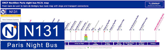
Paris Noctilien night bus N131 map with stops and transport connections
So here you have the maps and timetables for the Noctilien line N131 that also travels from Gare de Lyon but right through to Gare de Bretigny-sur-Orge and this night bus stops at Orly Ouest now Orly Airport 1-2-3 and Aeroport Terminal Sud now Orly Airport Terminal 4.
Paris night bus line N131 stops:
Paris Gare de Lyon - Van Gogh - Rue de Bercy, Gare d'Austerlitz - Quai d'Austerlitz*, Gare d'Austerlitz - Avenue Piere Mendes France**, Quai de la Gare - Quai de la Gare, Bibliotheque Chevaleret - Rue de Tolbiac, Airport Orly 4 - Quai 4, Airport Orly 1-2-3 - Quai 8, Aristide Briand - Avenue de Fontainebleau, Pyramide de Juvisy - Avenue Francois Mitterrand**, Pyramide de Juvisy - Avenue de la Cour de France*, Mairie de Juvisy - Avenue de la Cour de France, Gare de Juvisy - Rue du Marechal Juin, Blazy - Avenue du General De Gaulle, Savigny sur Orge RER - Place de la Gare*, Savigny sur Orge RER - Place de la Gare**, Gare d'Epinay sur Orge - Rue de Corbeil, Gare de Ste-Genevieve-des-Bois - Place du President Roosevelt, Gare de St-Michel-sur-Orge - Place de la Gare, Gare de Bretigny Sur Orge - Gare routiere - Place Pierre Vennin.
* In direction of Gare de Bretigny-sur-Orge - Gare routiere - Place Pierre Vennin. ** In direction of Paris Gare de Lyon - Van Gogh - Rue de Bercy.
Paris night bus line N131 main transport connections:
Metro lines: 1, 14. Train lines: A, D, R. Tram line: T7. Bus lines: N01, N02, N11, N16, N22, N31, N32, N33, N34, N35, N130, N132, N133, N134, N135, N144.
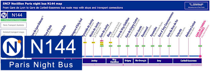
Paris Noctilien night bus N144 map with stops and transport connections
As you will discover from the night bus N144 maps and timetables, this now goes from Gare de Lyon - Diderot to Gare de Corbeil-Essonnes, although many plans still state the start point in Paris is Gare de l'Est so to get to that train station you would need to change bus lines, however, this still has one of the Noctilien bus stops at Aerogare d'Orly, which was named Orly Sud or South terminal, yet has changed to Orly 4 terminal since 2019.
Paris night bus line N144 stops:
Gare de Lyon - Diderot - Rue de Lyon*, Place d'Italie - Place d'Italie, Porte d'Italie, Airport Orly 4 - Quai 4, Pyramide de Juvisy - Avenue F. Mitterrand***, Pyramide de Juvisy - Avenue de la Cour de France**, Mairie de Juvisy - Avenue de la Cour de France - Avenue F. Mitterrand, Gare de Juvisy - Place du Marechal Joffre, Blazy - Avenue du General de Gaulle, Gare de Viry-Chatillon - Avenue du General de Gaulle, Gare de Grigny Centre - Route de Grigny (Centre Cial), Jean Jaures - Route de Grigny, Daumesnil - Avenue de la Liberation, Pyramides - Boulevard des Champs-Elysees, Gare d'Evry Courcouronnes - Gare routiere basse d'Evry, Gare du Bras de Fer - Bd des Coquibus, Tarterets - Bd Jean Jaures, Ambroise Croizat - Boulevard Jean Jaures, Gare de Corbeil-Essonnes - Place Henri Barbusse.
* For Gare de l'Est change to the N01 or N02. ** Night bus stop served in direction of Corbeil-Essonnes. *** Night bus stop served in direction of Paris Gare de Lyon.
Paris night bus line N144 main transport connections:
Metro Lines: 1, 14. Train Lines: A, D, R, TGV. Bus Lines: N01, N02, N15, N22, N31, N32, N33, N34, N35, N130, N131, N132, N133, N134, N135.
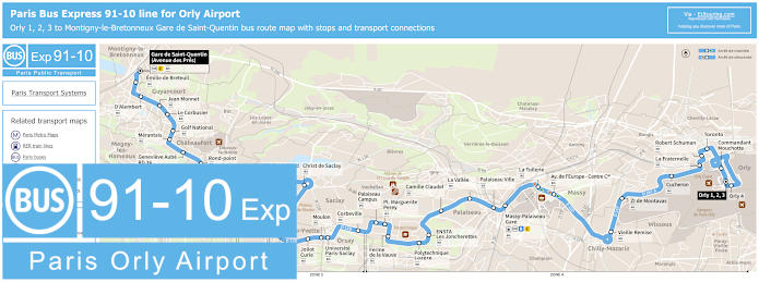
Paris bus express 91.10 map for Orly 1, 2, 3 to St-Quentin Gare with stops and transport connections
The Bus Express 91-10 goes from Montigny-le-Bretonneux - St-Quentin Gare travelling through many different communes or areas on the outskirts of Paris, with bus stops at transport hubs like Massy-Palaiseau Gare along its route before reaching Orly Airport Terminal 1,2,3 and Orly 4 and as you will see from the geographical maps and timetables, there are also different tariff zones for the 91-10 bus route, with Orly Airport being in Zone 4.
Paris Bus Express 91.10 line stops:
Montigny-le-Bretonneux - Gare de Saint-Quentin (avenue des Pres), Emilie de Breteuil, D'Alembert, Jean Monnet, Le Corbusier, Golf National, Merantais, Genevieve Aube - RD 36, Rond-Point, Le Thuit, Rond-Point - Maison Foujita, CEA Porte Nord, Christ de Saclay, Raoul Dautry - CEA Porte Sud, Mare du Vivier - CEA Porte Sud, Saint Aubin, Orme des Merisiers, Joliot Curie, Moulon, Universite Paris-Saclay, Corbeville, Palaiseau Campus, Pl. Marguerite Perey, Ferme de la Vauve, Polytechnique Lozere, ENSTA - Les Joncherettes, Camille Claudel, La Vallee, Palaiseau Ville, Massy-Palaiseau Gare, La Tuilerie, Avenue de l'Europe - Centre Commercial, Vielle Remise, ZI Montavas, Cucheron, La Fraternelle, Robert Schuman, Toronto, Commandant Mouchotte, Orly 4, Orly 1, 2, 3.
Paris Bus Express 91.10 main line transport connections:
Train Lines: B, C. Bus Lines: 91.03, 91.05, 91.06, 91.08, 91.11, CEAT, Hourtoule, Keolis Meyer, Mobicaps, Sqybus.
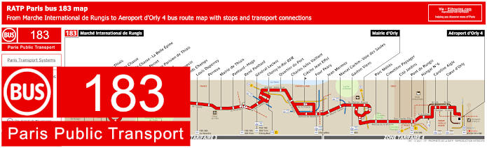
RATP Paris bus line 183 with stops, connections and street plan
Although here you can see the maps and timetables for the RATP Paris bus line 183 that travels from Marche International de Rungis to Aeroport d'Orly 4, which used to be called Orly Sud. Running daily including on French holidays but at different times, if however, you require Orly Airport 1,2,3 you would need to get the airport shuttle bus from Orly 4 Terminal.
Paris bus line 183 stops:
Marche International de Rungis, Porte de Thiais, Le Cor de Chasse*, Le Cor de Chasse - La Belle Epine**, Auguste Perret*, Cimetiere Parisien de Thiais, Bretagne, Paul Langevin, Grands Champs, Louis Duperrey, Perreux, Mairie de Thiais, Panhard - Hugo, Rene Panhard, General Leclerc, Choisy-le-Roi RER, Quartier du Port, Charles Jules Vaillant, Creche Jean Effel**, Four Peary, Jean Mermoz, Marcel Cachin - Voie des Saules, Gaston Viens, Mairie d'Orly, Parc Melies, Cimetiere Paysager, Cite Jardins, Pont de Rungis, Hangar No 6, Caroline Aigle, Coeur d'Orly, Aeroport d'Orly 4.
* Stop served in direction of Marche International de Rungis. ** Stop served in direction of Aeroport d'Orly 4.
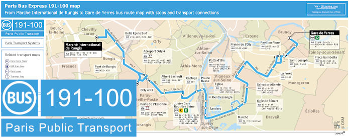
Paris bus Express 191-100 map for Orly Airport, Gare de Yerres, Chevilly-Larue and Gare De Juvisy with stops, connections and street plan
However, the Bus Express 191.100, also often shown as bus 191-100 run by the transport company Keolis, goes from the famous international Rungis Market at the stop called Marche International de Rungis to Aeroport Orly 1-2-3 and Aeroport Orly 4, with a terminus point of Gare de Yerres after travelling through different communes or areas of the Paris region, and on the maps with timetables you will also see the route with its bus stops and transport connections.
Paris bus Express 191-100 stops:
Marche International de Rungis, Belle Epine Sud, Pont de Rungis, Aeroport Orly 4*, Aeroport Orly 1-2-3, Aeroport Orly 4 - N7*, Porte de l'Essonne, Albert Sarrault, Cottage, Plaine Basse, N. Dentressangle, Sanders, Juvisy Gare, Marche**, Eglise***, Oree de Senart, Salvador Allende, Patte d'Oie, Prairie de l'Oly, La Foret, Pavillon Flore*, Saint Joseph*, Place Gambetta, Gare de Yerres.
* Only served in a specific direction. ** Bus stop not served on a Sunday. *** Alternative stop on a Sunday due to the local market.
Paris bus Express 191-100 main transport connections:
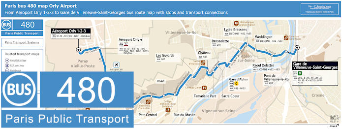
Paris bus 480 map for Orly Airport to Gare de Villeneuve-Saint-Georges with stops and connections
The Paris Bus 480 is run by transport company Keolis and travels between Gare de Villeneuve-Saint-Georges and Aeroport Orly 1-2-3, but it also stops at Orly Airport Terminal 4, plus haves several other bus stops like Gare d'Ablon that connects to the RER C train line.
Paris bus line 480 stops:
Aeroport Orly 1-2-3, Aeroport Orly 4, Porte de l'Essonne, Maison de l'Environnement, Parc Central, DGAC, Rue du Musse, Les Guyards, Chateau, Tamaris le Parc, Sacre Coeur, Gare d'Ablon, Brossolette, Lycee Brassens, Weddingen, Raoul Delattre, Pont de Villeneuve-le-Roi, Gare de Villeneuve-Saint-Georges.
Orly Airport GO C Paris shuttle bus map with stops and connections
The GO C Paris airport shuttle bus is a dedicated service for the RER C train line that goes from the Gare de Pont de Rungis stop, also known as just Pont de Rungis to Orly Airport, then as you can see from the maps and timetables, running every day of the year from early hours to late evening, the GO C bus connection travels directly to Terminal 1-2-3 of Orly Airport then to Orly Terminal 4.
GO C Paris shuttle bus stops:
Orly 4, Orly 1-2-3, Pont de Rungis
GO C Paris shuttle bus main transport connections:
Train lines: C, OrlyVal. Tram Line: T7. Bus lines: 8, 91-10, 183, 191-100, Bus Direct 1, Bus Direct 3, Magical Shuttle, N22, N31, N131, N144, OrlyBus.
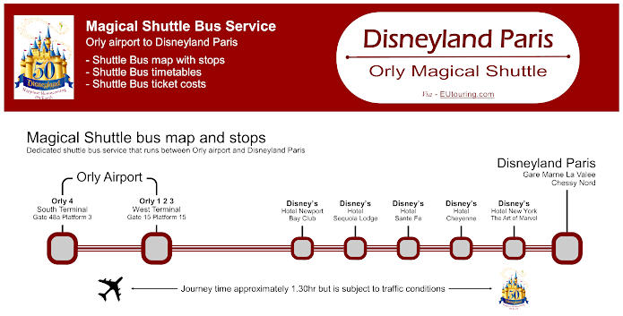
Magical Shuttle bus map for Orly Airport to Disneyland Paris with stops, timetables and ticket prices
For those of you flying into Orly Airport and going to Disneyland Paris, you will be pleased to know that there is a shuttle bus service called Magical Shuttle, which takes you directly to several different Disney Hotels, making this a convenient option for families and less hassle with your luggage, with the maps, timetables and ticket information even showing details of what the pick up and drop off points are at Orly Airport and Disneyland Paris.
Magical Shuttle bus Orly Airport to Disneyland Paris stops:
Orly 4 South Terminal Gate 48a Platform 3, Orly 1 2 3 West Terminal Gate 15 Platform 15, Hotel Newport Bay Club, Hotel Sequoia Lodge, Hotel Sante Fe, Hotel Cheyenne, Chessy Gare Routiere, Disneyland Hotel.
Magical Shuttle bus Orly Airport to Disneyland ticket prices:
Adult €23.00 one way Child (aged 3-12 years) €10.00 one way Child (aged -2 years) FREE
Price does not include entrance costs for Disneyland parks.
Magical Shuttle bus Orly to Disneyland maps, prices and timetables available:
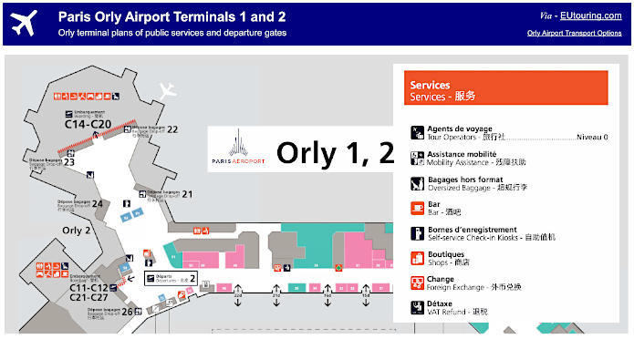
Orly terminals 1 and 2 plans of departure gates and public services
Orly Airport changed its name from Orly Ouest (West in English) to Orly 1,2,3 in 2019 and here are the plans showing Orly airport Terminal 1 and Terminal 2 with the different levels such as Level 0 for baggage claim upon arrival. In addition, Level 1 shows the Orly airport layout within the terminal departure areas such as baggage drop-off points, boarding gates, airline desks and lounges, services like toilets, foreign exchange, even a post office, children's area, food and drink, shops, how to get to the transport options and more.
Paris Orly airport terminals 1 and 2 plans available:
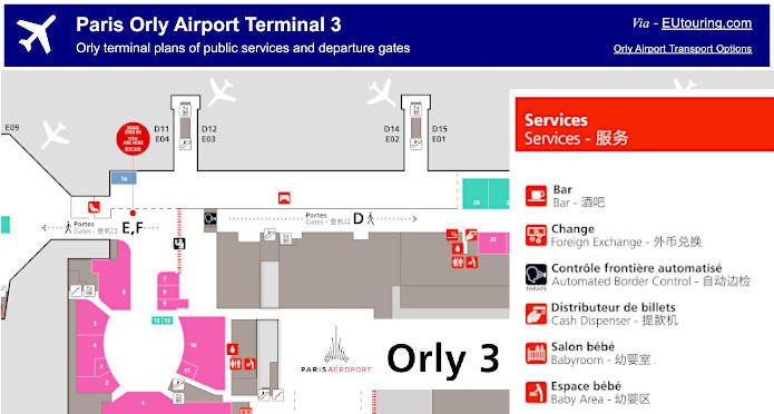
Orly terminal 3 plans of departure gates and public services
Here you can see the maps and plans for Orly Terminal 3, again with the different levels and services available within this part of Orly airport, which has an airport code name of ORY, and this also shows how to get to the other terminals internally with an approximate walking time, where the drop off points are located, again boarding gates, customs area, etc, so you can plan ahead before your flight.
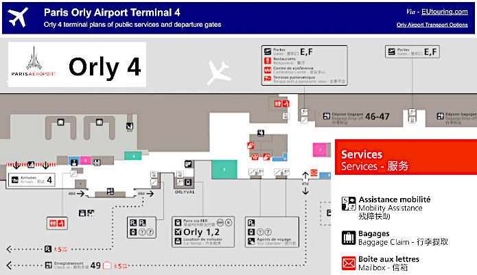
Orly terminal 4 plans of departure gates and public services
Originally called Orly Sud (South in English) for many years, here you can see the plan and layout for newly named Orly Terminal 4 with its many different public services including duty free shopping, bars and restaurants, etc. Additionally you can see the sections for Boarding E and Boarding F, along with convenient charging points for electronic equipment, reading lounges, designated smoking area and much more for your travel to run smoothly.
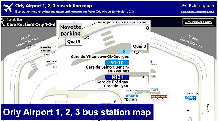
Orly 1-2-3 map of bus station with bus gates and bus numbers
Here you can see a plan showing the Gare Routiere for Orly 1-2-3 at Orly Airport, which used to be called Orly Ouest, or Orly West in English, and as you can see, this shows the various bus lines that arrive and depart at this airport bus station for terminals 1, 2 and 3 including Le Bus Direct, the Noctilien night bus N131 going to Paris and the Magical Shuttle for Disneyland Paris.
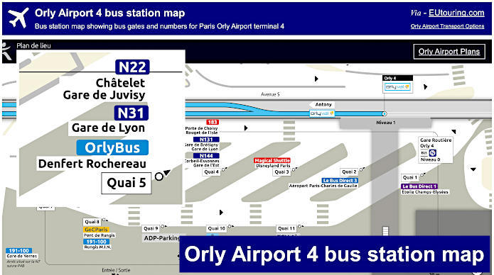
Orly 4 map of bus station with bus gates and bus numbers
Whereas this plan shows the Gare Routiere, or Bus station for Orly 4 terminal of Orly Airport, and as you can see, this shows specific buses like the Paris bus line 183 and the Noctilien night bus line N31 that goes to and from this particular Paris airport terminal, but you may be pleased to know that there is a shuttle service from here to Orly 1-2-3 terminals in case that is your designated arrival or departure point.
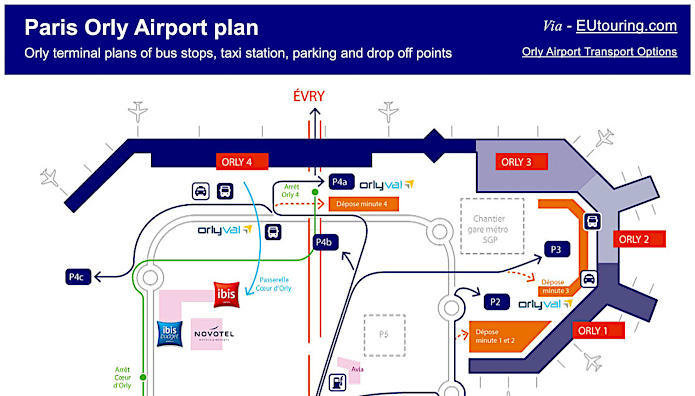
Orly Airport plan showing bus stops, taxi stations, parking and drop off points
Here you can see a plan of how to get to Orly airport with parking plus pick up and drop off points at the different airport terminals in addition to the shuttle services, taxi ranks, bus stations that are called a Gare Routiere in French, and even airport hotels plus the petrol station right by the car rental point.
Paris Orly airport plan of public services available: