How to get to Chateau de Versailles in Paris using public transport
The castle of Versailles is a very popular tourist attraction and below you can see how to get to Chateau de Versailles with public transport, whether it be by train, bus, from Paris via a dedicated shuttle service, etc, which include maps, plans, timetables and much more including plans of the grounds, that can all be downloaded in PDF or image file format for your home computer or mobile device.
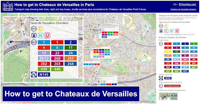
Chateau de Versailles transport map with trains lines, bus stops, shuttle services, connections and street plan
This first map and street plan by the famous Versailles Castle shows the various train stations along with other public transport options and connections including shuttle services plus day and night buses, to make getting to Chateau Versailles hassle free for everyone, whether it be directly from central Paris or the surrounding areas within the Paris region of Ile de France.
How to get to Chateau de Versailles public transport maps available:
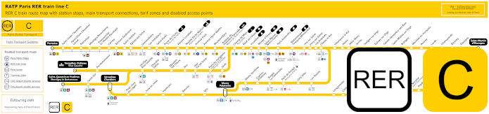
Yellow RER C train line map showing station stops, line branches, transport connections and zones
Here we have the RER C line with its many different branches that can get you directly from Paris to Chateau de Versailles from the Champs de Mars stop by the Eiffel Tower, the St-Michel - Notre Dame stop, the Gare d'Austerlitz train station and others, and you would need to ensure you head in the direction of Versailles Chateau Rive Gauche, which is actually the nearest train station to the castle and grounds main entrance at a distance of approximately 700 metres.
Paris RER C train line stops:
Pontoise*, St-Ouen l'Aumone, St-Ouen l'Aumone - Liesse, Pierrelaye, Montigny Beauchamp, Francoville - Le Plessis-Bouchard, Cernay, Ermont Eaubonne, St-Gratien, Epinay-sur-Seine, Gennevilliers, Les Gresillons, St-Ouen, Porte de Clichy, Pereire Levallois, Neuilly - Porte Maillot (Palais des Congres), Avenue Foch, Avenue Henri Martin, Boulainvilliers, Avenue du Pdt Kennedy (Maison de Radio France), Champ de Mars (Tour Eiffel), Pont d'Iena, Invalides, Musee d'Orsay, St-Michel (Notre Dame), Paris Gare d'Austerlitz, Bibliotheque Francois Mitterrand, Ivry-sur-Seine, Vitry-sur-Seine, Les Ardoines, Choisy le Roi, Villeneuve le Roi, Ablon, Athis Mons, Juvisy, Savigny-sur-Orge, Epinay-sur-Orge, Ste-Genevieve des Bois, St-Michel-sur Orge, Bretigny, Marolles en Hurepoix, Bouray, Lardy, Chamarande, Etrechy, Etampes, St-Martin d'Etampes*, Versailles Chateau Rive Gauche*, Porchefontaine, Viroflay Rive Gauche, Chaville - Velizy, Meudon - Val Fleury, Issy, Issy - Val de Seine, Pont du Garigliano (Hopital Europeen Georges Pompidou), Javel, St-Quentin en Yvelines*, St-Cyr, Versailles Chantiers**, Petit Jouy les Loges, Jouy en Josas, Vauboyen, Bievres, Igny, Massy Palaiseau**, Massy Verrieres, Chemin d'Antony, Rungis La Fraternelle, Pont de Rungis (Aeroport d'Orly), Orly Ville, Les Saules, Longjumeau, Chilly Mazarin, Gravigny Balizy, Petit Vaux, La Norville (St-Germain les Arpajon), Arpajon, Egly, Breuillet (Bruyeres le Chatel), St-Cheron, Sermaise, Dourdan, Dourdan la Foret*.
* Terminus Points. ** RER C Transfer Points.
Paris RER C train line main transport connections:
Metro Lines: 1, 2, 3, 4, 5, 6, 8, 9, 10, 12, 13, 14. Train Lines: B, D, H, J, N, U, TGV, TER. Tram Lines: T1, T2, T3a, T3b, T6, T7, T8, T9, T11, T13. Bus Lines: 183, 393, PC (98), TVM (14).
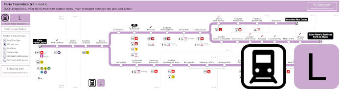
Transilien train line L map showing station stops, line branches, transport connections and zones
This is the Transilien train line L, which starts at the Paris train station of Gare Saint-Lazare, then branches off to different places, and as you can see from the maps, one of its route terminus points is Versailles Rive Droite also called Gare de Versailles Rive Droite, which is the train stop you would need in order to get to the Chateau de Versailles around 1600 metres from the famous castle.
Paris train line L stops:
Paris Saint-Lazare*, Pont Cardinet, Clichy Levallois, Asnieres sur Seine, Becon les Bruyeres, Courbevoie, La Defense (Grande Arche), Puteaux, Suresnes - Mont Valerien, Le Val d'Or, St-Cloud, Sevres - Ville d'Avray, Chaville Rive Droite, Viroflay Rive Droite, Montreuil, Versailles Rive Droite*, Garches - Marnes la Coquette, Vaucresson, La Celle St-Cloud, Bougival, Louveciennes, Marly le Roi, L'Etang la Ville, St-Nom la Breteche - Foret de Marly**, Noisy le Roi*, Mareil Marly, St-Germain en Laye - Bel Air Fourqueux, St-Germain en Laye G.C.*, Les Vallees, La Garenne Colombes, Nanterre Universite, Houilles - Carrieres sur Seine, Sartrouville, Maisons Lafitte, Acheres Ville, Conflans - Fin d'Oise, Neuville Universite, Cergy - Prefecture, Cergy - St-Christophe, Cergy le Haut*.
* Terminus Points. ** Train L Transfer Point.
Paris train line L main transport connections:
Metro Lines: 1, 3, 9, 12, 13, 14. Trian Lines: A, E, J, U, TER. Tram Lines: T2, T6, T13.
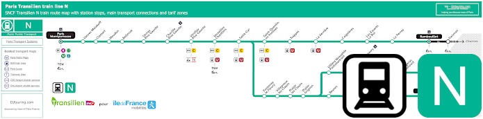
Transilien train line N map showing station stops, line branches, transport connections and zones
Whereas this shows the maps for the Transilien line N train that goes from the Gare Montparnasse train station, and as you can see, from Paris Montparnasse you can head in any direction of the train route because you need the stop Versailles Chantiers, also referred to as Gare de Versailles Chantiers, before the line splits off to various destinations, and this train station is approximately 1500 metres from the chateau.
Paris train line N stops:
Paris Montparnasse*, Vanves - Malakoff, Clamart, Meudon, Bellevue, Sevres Rive Gauche, Chaville Rive Gauche, Viroflay Rive Gauche, Versailles Chantiers, Saint-Cyr, Saint-Quentin en Yvelines, Trappes, La Verriere, Goignieres, Les Essarts Le Roi, Le Perray, Rambouillet*, Fontenay le Fleury, Villepreux les Clayes, Plaisir les Clayes, Plaisir Grignon, Beynes, Mareil sur Mauldre, Maule, Nezel Aulnay, Epone Mezieres, Mantes la Jolie*, Villiers - Neauphle Pontchartrain, Montfort l'Amaury Mere, Grancieres La Queue, Orgerus Behoust, Tacoignieres Richebourg, Houdan, Marchezais Broue, Dreux*.
* Terminus Points.
Paris train line N main transport connections:
Metro Lines: 4, 6, 12, 13. Train Lines: C, J, U, TER, TGV. Tram Line: T6.
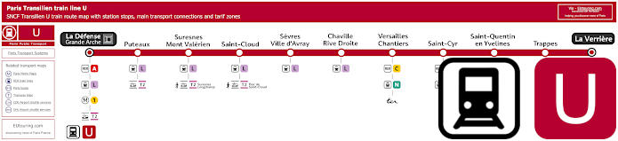
Transilien train line U map showing station stops, transport connections and zones
Again having a stop at the train station Gare de Versailles Chantiers for you to reach the impressive castle, the Transilien train line U goes from La Defense by the Grande Arche in the business district of Paris, through to La Verriere, and as you can see from the maps, there are various transport connections on its train route.
Paris train line U stops:
La Defense - Grande Arche*, Puteaux, Suresnes - Mont Valerien, St-Cloud, Sevres - Ville-d'Avray, Chaville Rive Droite, Versailles Chantiers, St-Cyr, St-Quentin en Yvelines, Trappes, La Verriere*.
* Terminus Points.
Paris train line U main transport connections:
Metro Line: 1. Train Lines: A, C, L, N, TER. Tram Line: T2.
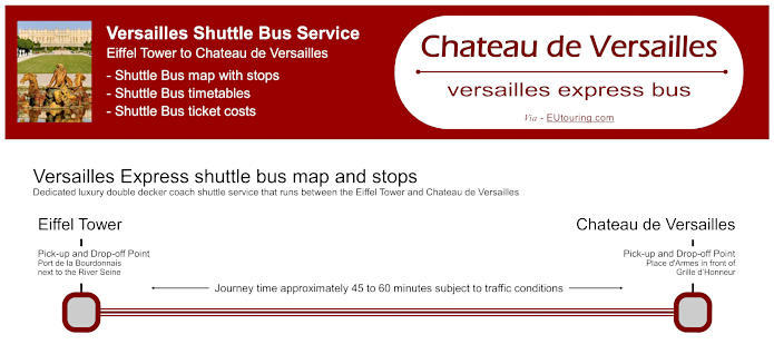
Versailles Express buses map with stops, timetables and ticket prices
This shows the Versailles Express, which is a dedicated shuttle bus from Paris to Chateau de Versailles, and as you can see from the information with its pick-up and drop off points, ticketing costs plus more, there are different options, whether you just wish to utilise the shuttle and enjoy the grounds, pay for entry tickets to the palace itself and so on, which makes this a great option for all the family, especially since you are taken right to the entrance.
Versailles Express bus pick up points:
Eiffel Tower Port de la Bourdonnais next to the River Seine. Chateau de Versailles Place d'Armes in front of Grille d’Honneur.
Versailles Express bus ticket prices:
Adult Half Day €29.00 Standard return and entrance to grounds. Adult Half Day €42.00 Standard return and entrance to grounds + Entrance to Palace Versailles with audio guide. Adult Full Day €52.00 Standard return and entrance to grounds + Entrance to Palace Versailles with audio guide + Entrance to gardens, even on days of Fountains Shows and Musical Gardens + Mini-train admission + Entrance to Palaces of Trianon and the Estate of Marie-Antoinette. Childen aged 0-9 years FREE Each child must be accompanied by an adult with paid admission.
Buying Versailles Express bus tickets:
You must purchase your Versailles Express bus ticket prior to trip, which can be ordered online at their website - Versailles Express.
Download Versailles Express bus maps with timetables and ticket prices:
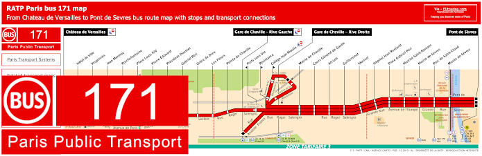
RATP Paris bus line 171 with stops, connections and street plan
Whereas here you have the RATP bus line 171 that travels from Pont de Sevres to Chateau de Versailles, yet please look at the bus route map and timetables carefully, as there are also 2 other terminus points at certain hours, even though there is a bus approximately every 10 minutes between 9:50am and 4:45pm on a Monday to Friday from Pont de Sevres to the famous tourist attraction of Chateau de Versailles, and this route will get you the closest to the palace than any other.
Paris bus line 171 stops:
Chateau de Versailles, Hotel de Ville, Vergennes, Jean Mermoz, Porchefontaine, Place Louis XIV, Pierre Edouard, President Doumer, Gabriel Peri, Grace de Dieu, Les Fleurs, Pointe de Chaville, Gare de Chaville - Rive Gauche, Securite Sociale, College Jean Moulin, Gare de Chaville - Rive Droite, Puits Sans Vin, Cours General de Gaulle, Atrium, Guilleminot, Marivel, Hopital Jean Rostand, Place Gabriel Peri, Marche Saint-Romain, Mairie de Sevres, Parc de Saint-Cloud, Musee de Sevres, Pont de Sevres.
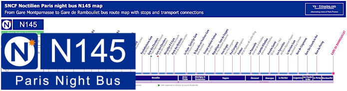
Paris Noctilien night bus N145 map with stops and transport connections
Now here is the Noctilien line N145, which is a night bus service operating between 12:30am and 5:30am and this particular night bus route goes from Paris Gare Montparnasse to La Verriere Gare or Gare de Rambouillet travelling through many different communes, or areas, that includes Versailles Rive Gauche Gare, which is actually the closest train station to Chateau de Versailles. Yet we would like to point out that some stops are only served in a particular direction or are only served on certain days.
Paris night bus line N145 stops:
Gare Montparnasse - Gare routiere Place Raoul Dautry***, Porte de Versailles - Rue de Vaugirard*, Balard - Avenue de la Porte de Sevres, Marcel Sembat - Avenue Paul Vaillant Couturier, Mairie de Sevres - Sevres Rive Gauche - Avenue de l'Europe, Hopital Jean Rostand - Grande Rue, Atrium - Avenue Roger Salengro, Puits Sans Vin - Chaville Rive Gauche - Av. Roger Salengro, Grace de Dieu - Av. General Leclerc, Gabriel Peri - Viroflay Rive Gauche - Av. du General Leclerc, Pierre Edouard - Avenue du General Leclerc, Porchefontaine Gare - Avenue de Paris, Gare des Chantiers - Place Raymond Poincare**, Gare des Chantiers - Rue des Chantiers*, Versailles Rive Gauche Gare - Avenue du General de Gaulle, Porte des Matelots - Rue de la Division Leclerc, La Poste - Saint-Cyr Gare - Avenue Pierre Curie, Saint-Quenin en Yvelines Gare - Gare Routiere, Groupe scolaire Pasteur - Avenue des Pres, Republique - Gare de Trappes - Av. Paul Vaillant Couturier, Yves Farges - Rue Paul Langevin, Paul Langevin - Place Paul Langevin, Pasteur - Boulevard du Pasteur M. Luther King, La Passerelle - Avenue de la Villedieu, La petite Villedieu - Avenue de la Villedieu, Franche Comte - Boulevard du 19 Mars 1962, Les Pyramides - Bd. Rene Ressejac Duparc, La Verriere Gare - Boulevard Guy Schuler, Gare de Coignieres, Gare des Essarts-le-Roi, Gare du Perray, Gare de Rambouillet.
* Stop served in the direction of Gare Montparnasse. ** Stop served in direction of La Verriere Gare or Gare de Rambouillet. *** For Gare de l'Est change to night bus line N01 or N02.
Paris night bus line N145 main transport connections:
Metro Lines: 4, 6, 12, 13. Train Line: N. Bus Lines: N01, N02, N12, N13, N61, N62, N63.
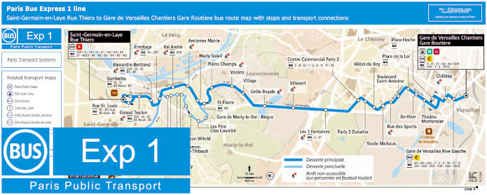
Paris bus express 1 map Versailles to Saint-Germain-en-Laye with stops and transport connections
The above geographical maps and timetables show the Bus Express 1 bus route from the communes of Saint-Germain-en-Laye to Versailles, at the bus stops of Rue Thiers to Gare de Versailles Chantiers - Gare Routiere, which is the bus station located right by the train station that is only around a 15 minute walk from the Chateau de Versailles, although this express 1 bus line also has a bus stop called Chateau that is even closer.
Paris Bus Express 1 stops desserte principale (Main Service):
Saint-Germain-en-Laye - Rue Thiers, Rue St Louis*, Gambetta*, Giraud Teulon, Alexandre Bertrand, Ermitage, Val Andre, Ancienne Mairie, Marly Soleil, St Fiacre*, Plains Champs, Voisins, Village, grille Royale, Villevert, Les 3 Fontaines, Centre Commercial Parly II, Parly 2 Dutartre, Allees du Roy, Place de la Loi, Stade Michaux, Rue des Sports, Boulevard Saint-Antoine, Place de la Loi, Berthier, Theatre Montansier, Place Hoche*, Chateau, Gare de Versailles Rive Gauche, Gare de Versailles Chantiers - Gare Routiere.
Paris Bus Express 1 stops desserte ponctuelle (Point Service):
Lycee International, Reservoir*, Nicot, Les Lampes, Square de Monte Cristo, Square de Versailles, Le Verger St-Exupery, Ramon St-Thibault, Jean Witold*, Les Pins Clos Courche, Gare de Marly-le-Roi - Beque.
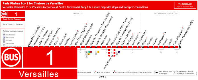
Paris Phebus 1 bus map Le Chesnay-Rocquencourt Centre Commercial Parly 2 to Versailles Universite with stops and transport connections
Bus line 1 is run by the transport company Phebus in the Versailles area and travels from Le Chesnay-Rocquencourt Centre Commercial Parly 2 through to Versailles Universite with bus stops along the way that will get you within easy reach of the former royal palace and its grounds, which include Gare de Versailles Chateau Rive Gauche train station that is closest to the main entrance for the famous castle. Yet we would like to point out that some stops are only served in a specific direction or at specific hours.
Paris Phebus 1 bus line stops:
Centre Commercial Parly 2, Parly 2 - Dutartre, Jasmin, Pottier, Redingote, Acacias, Corneille, Kleber*, Place Laboulaye, Saint-Jean, De Bange, Beauvau Remilly, Gare de Versailles Rive Droite, Place du Marche - Notre Dame, Notre-Dame**, Europe, Prefecture, Gare de Versailles Chateau Rive Gauche, Gare de Versailles Chantiers - Gare Routiere, Vergennes, Coypel Champ Lagarde, Villa Champ Lagarde, Saint-Charles, Vauban, Grand Siecle, Bazin, Gare de Montreuil, Antoine Richard, Cote de Picardie, Universite - Prevert*, Versailles Universite.
* Stops served only in a specific direction. ** Stop only served at specific hours.
Paris Phebus 1 bus line main transport connections:
Train Lines: C, L, N, U.
Paris Phebus 1 bus Versailles route maps available:
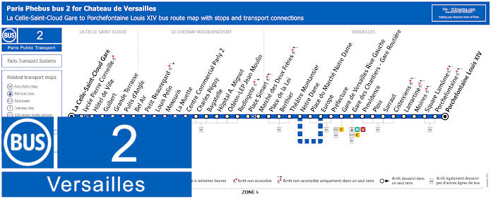
Paris Phebus 2 bus map La Celle-Saint-Cloud Gare to Porchefontaine Louis XIV with stops and transport connections
Whereas this is the Phebus bus line 2, and when you look at the geographical and street plan maps with the timetables and information, you will see that this bus route replaced previous lines, which now travels between Gare de la Celle-Saint-Cloud and Versailles Porchefontaine Louis XIV, having stops between like at the train station of Gare de Versailles Chateau Rive Gauche and Gare de Versailles Chantiers Gare Routiere bus station.
Paris Phebus 2 bus line stops:
Gare de La Celle-Saint-Cloud, Lycee Pierre Corneille*, Hotel de Ville, Guibert, Grande Terrasse, Puits d'Angle, Bel Air, Petit Beauregard, Louis Pelin, Moxouris, La Muette, Centre Commercial Parly 2, Charles Peguy, Bagatelle, Hopital A. Mignot, Odeon - LEP Jean Moulin, Redingote, Place Simart, Marche des Deux Freres*, Place de la Loi, Berthier, Theatre Montansier, Notre Dame, Place du Marche Notre Dame**, Europe, Prefecture, Gare de Varsailles Chateau Rive Gauche, Gare de Versailles Chantiers - Gare Routiere, Providence, Ploix, Sarraut, Cisterciens, Lamartine, Moines, Square Lamome, Porchefontaine, Versailles Porchefontaine Louis XIV.
* Stop served in only one direction. ** Not served during certain hours.
Paris Phebus 2 bus line main transport connections:
Train Lines: C, L, N, U.
Paris Phebus 2 bus Versailles route maps available:
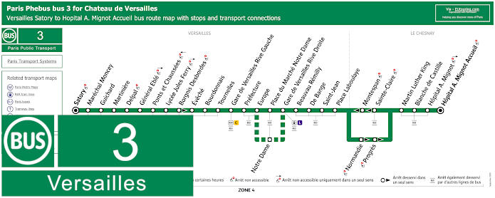
Paris Phebus 3 bus map Versailles Satory to Hopital A. Mignot Accueil with stops and transport connections
The maps and timetables along with additional information for the Phebus Bus route 3 show this travels between Le Chesnay-Rocquencourt - Hopital A. Mignot Accueil and Versailles Satory, yet as you can see there are some bus stops only served in a certain direction or at specific times and on the journey there are several bus stops that also have numerous other transport connections, just like Gare de Versailles Chateau Rive Gauche, although the bus stop Prefecture is even closer to the Versailles Palace.
Paris Phebus 3 bus line stops:
Versailles Satory, Marechal Moncey, Guichard, Martiniere, Delpal, General Eble, Ponts et Chaussees, Lycee Jules Ferry, Borgnis Desbordes*, Eveche, Bourdonnais, Tournelles, Gare de Versailles Chateau Rive Gauche, Prefecture, Europe, Notre Dame**, Place du Marche Notre Dame, Gare de Versailles Rive Droite, Beauvau Remilly, De Bange, Saint-Jean, Place Laboulaye, Normandie*, Progres*, Montespan*, Sainte-Clare*, Martin Luther King, Blanche de Castille, Hopital A. Mignot, Le Chesnay-Rocquencourt - Hopital A. Mignot Accueil.
* Stop only served in a certain direction. ** Only served on a Sunday during certain hours.
Paris Phebus 3 bus line main transport connections:
Train Lines: C, L
Paris Phebus 3 bus Versailles route maps available:
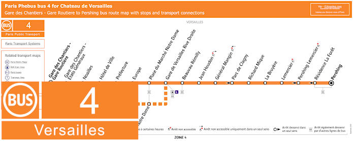
Paris Phebus 4 bus map Gare des Chantiers - Gare Routiere to Pershing with stops, connections and street plan
So here is the Bus line 4, also run by Phebus, which travels from Gare de Chantiers - Gare Routiere to Versailles Pershing and as you can see from the street map and timetables, there is a bus stop called Prefecture exceedingly close to the Place d'Armes, which is right by the Chateau de Versailles entrance, but we would like to point out that some stops are only served in a particular direction.
Paris Phebus 4 bus line stops:
Versailles Pershing, Residence La Foret*, Pershing Lemercier*, Lemercier, La Bruyere, Richard Mique, Parc de Clagny*, General Mangin, Jean Houdon, Beauvau Remilly, Gare de Versaillesd Rive Droite, Place du Marche Notre Dame, Notre Dame**, Europe, Prefecture, Hotel de Ville, Noailles, Gare des Chantiers - Etats Generaux, Gare de Chantiers - Gare Routiere.
* Bus stops only served in the direction of Gare de Chantiers - Gare Routiere. ** Only served on specific hours.
Paris Phebus 4 bus line main transport connections:
Train Lines: C, L, N, U. Bus Lines: 1, 2, 3, 5, 8, 10, 11, 13, 17, 39.12, 439, 440, 471, Express 1.
Paris Phebus 4 bus Versailles route maps available:
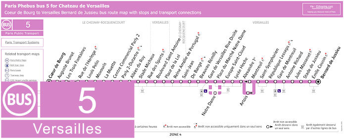
Paris Phebus 5 bus map Coeur de Bourg to Versailles Bernard de Jussieu with stops, connections and street plan
However, bus line 5 that travels between Versailles Bernard de Jussieu and Le Chesnay Rocquencourt - Coeur de Bourg also has a bus stop called Europe, which is closer to the Chateau de Versailles main entrance, rather than just alighting at the train station of Gare de Versailles Rive Droite, saving a good few minutes walk, yet as you can see from the maps and timetables, there are some stops only served in a particular direction.
Paris Phebus 5 bus line stops:
Le Chesnay Rocquencourt - Coeur de Bourg, Stade Auguste Brunot**, Les Trois Fontaines**, Rue de l'Horloge*, Louis Pelin, Moxouris, La Muette, Centre Commercial Parly 2, Parly 2 - Dutartre, Allees du Roy, Stade Michaux, Rue des Sports, Boulevard Saint Antoine, Place de la Loi, Reine Amelie du Portugal, Saint-Jean, De Bange, Beauvau Remilly, Gare de Versailles Rive Droite, Place du Marche Notre Dame, Notre-Dame***, Europe Saint-Cloud, Lycee Hoche, Alexandre 1er, Montreuil*, Artois**, Saint-Symphorien, Republique Lesseps, Versailles Gare de Montreuil, Antoine Richard, Jules Massenet, Stade de Jussieu, Emile Cousin, Versailles Bernard de Jussieu.
* Served in direction of Le Chesnay Rocquencourt - Coeur de Bourg. ** Served in direction of Versailles Bernard de Jussieu. *** Served on a Sunday at specific hours.
Paris Phebus 5 bus line main transport connections:
Train Line: L. Tram Line: T6. Bus Lines: 1, 3, 4, 7, 8, 17, 471.
Paris Phebus 5 bus Versailles route maps available:
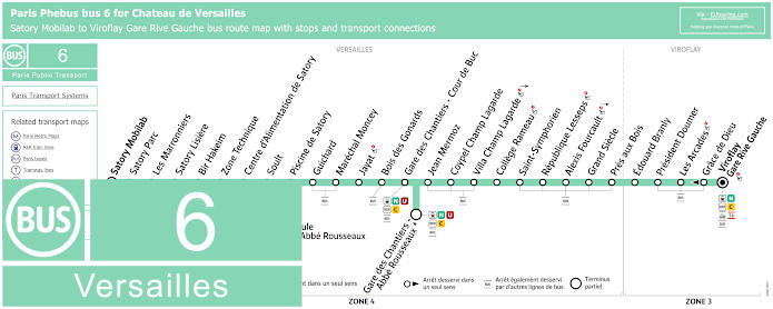
Paris Phebus 6 bus map Satory Mobilab to Viroflay Gare Rive Gauche with stops and transport connections
Yet the map above shows the Bus line 6 run by the transport company Phebus where you can also see timetables and information about the original bus lines it replaced. Yet this line 6 bus route now travels between Versailles - Satory Mobilab and Viroflay Gare Rive Gauche, which also has bus stops at Gare de Versailles Chantiers - Cour de Buc and on a weekend plus French holidays also at Gare de Versailles Chantiers - Abbe Rousseau.
Paris Phebus 6 bus line stops:
Versailles - Satory Mobilab, Satory Parc, Les Marronniers, Satory Lisiere, Bir Hakeim, Zone Technique, Centre d'Alimentation de Satory, Soult, Piscine de Satory, Guichard, Marechal Moncey, Jayat, Bois des Gonards, Gare de Chantiers - Cour de Buc, Gare de Chantiers - Abbe Rousseaux, Jean Mermoz, Coypel Champ Lagarde, Villa Champ Lagarde, College Rameau, Saint-Symphorien, Republique Lesseps, Alexis Fourcault, Grand Siecle, Pres aux Bois, Edouard Branly, President Doumer, Les Arcades, Grace de Dieu*, Viroflay Gare Rive Gauche.
* Only served in the direction of Satory Mobilab.
Paris Phebus 6 bus line main transport connections:
Train Lines: C, L, N, U. Tram Line: T6. Bus Lines: 7, 260, 261, 262, 263, 264, 307.
Paris Phebus 6 bus Versailles route maps available:
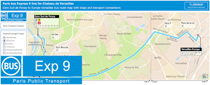
Paris bus Express 9 Gare Sud de Poissy to Versailles Europe map with stops and transport connections
Although here is the Bus Express 9 from Poissy to Versailles, which travels from Gare Sud de Poissy to Europe, also referred to as the Versailles Europe bus stop as there is more than one stop with the name Europe! Yet as you can see from the geographical maps and timetables, this is a true express bus line as there are only four stops on its bus route in either direction that travel through different communes of the Paris region.
Paris bus Express 9 stops:
Gare Sud de Poissy, Le Cep, Rhin Danube*, Lycee Le Corbusier*, Parly 2, Place de la Loi, Versailles Europe.
* Bus stop served in a particular direction only.
Paris bus Express 9 main transport connections:
Train lines: A, J. Bus lines: 1, 2, 3, 4, 5, 8, 10, 13, 14, 20, 22, 23, 24, 26, 54, Express 19.
Paris bus Express 9 Versailles route maps available:
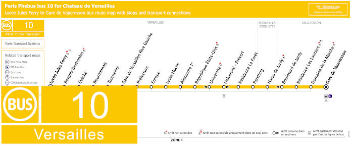
Paris Phebus 10 bus map Lycee Jules Ferry to Gare de Vaucresson with stops, connections and street plan
The maps and timetables above show the bus line 10 run by Phebus within the Paris region of Ile de France, and going between Gare de Vaucresson through to Versailles Lycee Jules Ferry, there are main stops on its bus route that include Gare de Versailles Rive Gauche, although even closer and a shorter walk to Chateau de Versailles, you could get off at bus stop Prefecture or if not the Europe bus stop.
Paris Phebus 10 bus line stops:
Gare de Vaucresson, Domaine de la Marche, Residence Les Lauriers, Boulevard de Jardy*, Haras de Jardy, Pershing, Residence La Foret, Universite - Prevert**, Universite*, Republique Etats-Unis, Alexandre 1er, Lycee Hoche, Europe, Prefecture, Gare de Versailles Rive Gauche, Tournelles, Bourdonnais, Eveche, Borgnis-Desbordes**, Versailles Lycee Jules Ferry.
* Stop only served in direction of Lycee Jules Ferry. ** Stop only served in direction of Gare de Vaucresson.
Paris Phebus 10 bus line main transport connections:
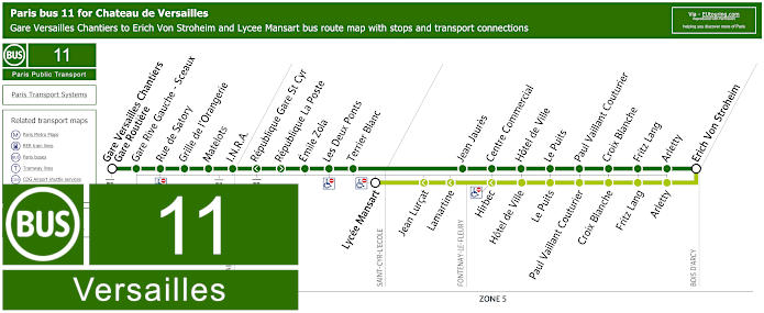
Paris bus 11 map Gare Versailles Chantiers to Bois d'Arcy with stops and transport connections
Yet here is the bus line 11 run by the transport company Hourtoule, which is the dark green line travelling between Bois d'Arcy - Erich Von Stroheim to Versailles - Gare de Versailles Chantiers Gare Routiere bus station with several stops and transport connections on its route including Versailles Gare Rive Gauche - Sceaux located close to the famous castle.
Paris bus 11 line stops:
Gare Versailles Chantiers - Gare Routiere, Gare Rive Gauche - Sceaux, Rue de Satory, Grille de l'Orangerie, Matelots, I.N.R.A., Republique Gare St Cyr*, Republique La Poste**, Les Deux Ponts, Terrier Blanc, Lycee Mansart***, Jean Lurcat***, Lamartine***, Jean Haures, Hirtbec***, Centre Commercial, Hotel de Ville, Le Puits, Paul Vaillant Couturier, Croix Blanche, Fritz Lange, Arletty, Erich Von Stroheim.
* Stop only served in the direction of Gare Versailles Chantiers - Gare Routiere. ** Stop only served in the direction of Erich Von Stroheim. *** Unique to the school service to Lycee Mansart.
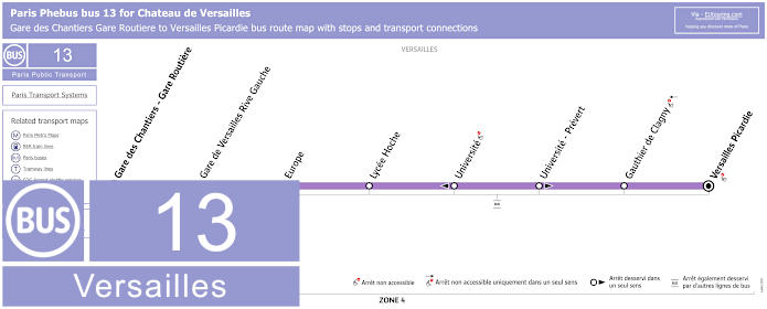
Paris Phebus 13 bus map Gare de Chantiers to Versailles Picardie with stops, connections and street plan
However, this is the bus line 13 run by transport company Phebus with its geographical map, timetables and information including connections to other bus routes and trains at Gare de Versailles Chantiers Gare Routiere and Gare de Chateau Rive Gauche, and as you can see this travels to Versailles Picardie stop servicing the University at specific hours on a Monday to Friday.
Paris Phebus 13 bus line stops:
Gare de Chantiers - Gare Routiere, Gare de Versailles Rive Gauche, Europe, Lycee Hoche, Universite*, Universite - Prevert*, Gauthier de Clagny, Versailles Picardie.
* Stop only served in one direction.
Paris Phebus 13 bus line main transport connections:
Train lines: C, N, U.
Paris Phebus 13 bus Versailles route maps available:
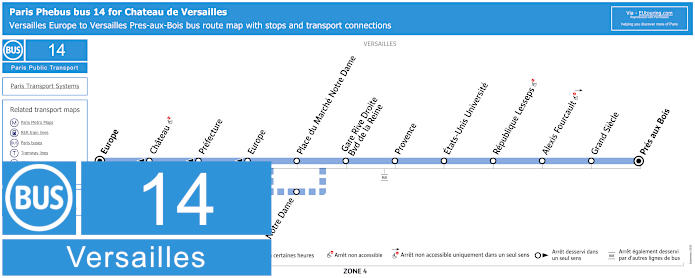
Paris Phebus 14 bus map Versailles Europe to Versailles Pres Aux Bois with stops, connections and street plan
The Phebus bus 14 has a route going from Versailles Europe to Versailles Pres aux Bois, and as you can see from the maps and timetables some stops like Chateau, which is the closest bus stop to the palace right by the Place d'Armes, are only served in a certain direction, and there is also a slight deviation in the bus route at certain times due to the local market.
Paris Phebus 14 bus line stops:
Versailles - Pres aux Bois, Grand Siecle, Alexis Fourcault, Republique Lesseps, Etats-Unis Universite, Provence, Gare Rive Droite - Boulevard de la Reine, Place du Marche Notre Dame, Notre Dame**, Versailles Europe*, Prefecture*, Chateau (Chateau de Versailles)*, Versailles Europe.
* Only served in the direction of Versailles Europe Line Terminus. ** Stop served on a Sunday at specific hours.
Paris Phebus 14 bus line main transport connections:
Train lines: C, L. Bus lines: 1, 2, 3, 4, 5, 9, 10, 13, 14, 19, 23.
Paris Phebus 14 bus Versailles route maps available:
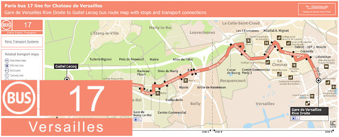
Paris bus 17 route map Versailles to Saint-nom-la-Breteche with stops and transport connections
But the Bus line 17 travels between Versailles and Saint-Nom-la-Breteche going from Guitel Lecoq to Gare de Versailles Rive Droite, and as you can tell from the timetables and geographical map, the bus route travels through different communes of the Paris region including Noisy-le-Roi and Rocquencourt with numerous bus stops that are served at different times during the year.
Paris bus 17 line stops:
Gare de Versailles Rive-Droite, Laboulaye, Corneille, Odeon - LEP J. Moulin, Hopital A. Mignot, Centre Commercial Parly 2, Les 3 Fontaines, Coeur de Bourg, Grille de Maintenon, Allee du Tillet, Mairie, Oree de Marly*, Centre Commercial**, Gallarderie**, Marie*, Gare de Noisy-le-Roi, Hameau Fleuri, Pres de Renneuil, Tuilerie, Tuilerie Bignon, Clos Salibert, Carrefour 307*, Pre Saint-Nom Sud, Guitel Lecoq.
* Served in direction Saint-Nom-la-Breteche - Guitel Lecoq. ** Served in direction Versailles - Gare de Versailles Rive Droite.
Paris bus 17 main transport connections:
Train line: L. Bus lines: 1, 3, 4, 5, 14, 17, 40, 471.
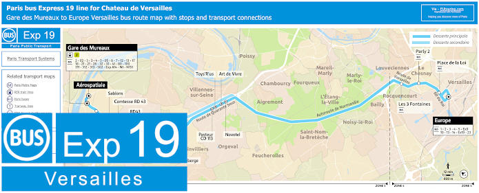
Paris bus Express 19 route map Versailles to Les Mureaux with stops and transport connections
Here we have the maps and timetables for the Bus Express 19 that travels between the areas of Versailles and Les Mureaux, with the primary bus route going from Gare des Mureaux to Europe, also know as the bus stop Versailles - Europe, yet there is a secondary route, which is even quicker and served at specific times going from Aeropspatiale to Europe.
Paris bus Express 19 line stops:
Aerospatiale, Gare des Mureaux, CC Bougimonts, CC Espace, Sablons, Comtesse RD 43 *, La Chamoiserie *, RD 43, Presles ZI RD 43 *, Presles *, Auberge, Toys 'R' Us *, Pasteur CD113 *, Art de Vivre *, Novotel *, Les 3 Fontaines, Parly 2, Place de la Loi, Europe.
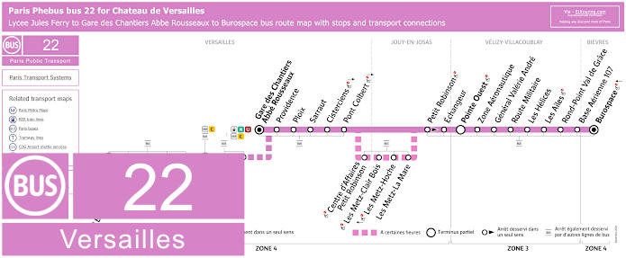
Paris bus 22 map Versailles Gare des Chantiers to Bievres Burospace with stops and connections
Whereas the bus line 22, run by the transport company Phebus, has a principal bus route from Bievres - Burospace to Versailles Gare des Chantiers - Abbe Rousseaux, although as you will see from the maps and timetables, the start is sometimes Velizy-Villacoublay - Pointe Ouest to Versailles Gare Rive Gauche, yet sometimes the bus route goes to Lycee Jules Ferry during specific hours and times of the year.
Paris bus 22 line stops:
Bievres - Burospace, Base Aerienne 107, Rond-Point - Val de Grace, Les Ailes, Les Helices, Route Militaire, General Valerie Andre, Zone Aeronautique, Pointe Ouest***, Echangeur, Petit Robinson**, Les Metz - La Mare*, Les Metz - Hoche*, Les Metz - Clair Bois*, Centre d'Affaires Petit Robinson*, Pont Colbert, Cisterciens, Sarraut, Ploix, Providence, Gare des Chantiers - Abbe Rousseaux, Vergennes*, Hotel de Ville* **, Gare de Versailles Rive Gauche*, Tournelles*, Bourdonnais*, Eveche*, Borgnis Desbordes* **, Lycee Jules Ferry*.
* Bus stops only served at specific times. ** Stop only served in direction of Bievres - Burospace. *** A partial terminus stop.
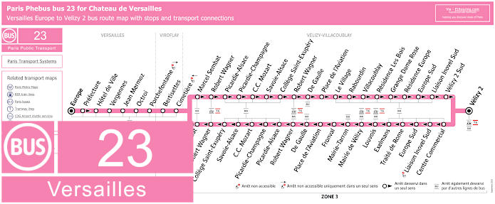
Paris bus 23 map Versailles Europe to Velizy-Villacoublay Velizy 2 with stops and connections
Run by the transport company Phebus in conjunction with Keolis, the bus line 23 goes from Europe, sometimes referred to as the bus stop Versailles - Europe, through to Velizy-Villacoublay - Velizy 2, and as you will see from the maps and timetables with the transport connections, there are several stops that are only served in a particular direction.
Paris bus 23 line stops:
Versailles - Europe, Prefecture*, Hotel de Ville, Vergennes, Jean Mermoz, Octroi, Porchefontaine, Viroflay - Bertisettes, Cimetiere, Velizy-Villacoublay - Marcel Sembat, Robert Wagner, Picardie-Alsace, Picardie-Champagne, Centre Commercial Mozart, Savoie-Alsace, College Saint-Exupery, Robert Wagner, De Gaulle, Place de l'Aviation, Le Village*, Fronval**, Rabourdin*, Mairie-Tarron**, Villacoublay*, Mairie de Velizy**, Louvois**, Residence Les Bois*, Grange Dame Rose*, Exelmans**, Residence Europe*, Traite de Rome**, Europe Sud, Liaison Inovel Sud, Velizy 2 Sud*, Centre Commercial**, Velizy 2 Sud, Velizy 2.
* Served in the direction of Velizy-Villacoublay - Velizy 2. ** Served in the direction of Versailles - Europe.
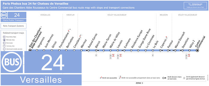
Paris Phebus 24 bus map Versailles Gare des Chantiers to Velizy-Villacoublay with stops and transport connections
Whereas these are the maps and timetables for the Phebus bus line 24 that goes from Gare de Versailles Chantiers - Abbe Rousseaux to Velizy Centre Commercial, which travels through different communes, or areas like Meudon on its route, however, as you will see, there are some bus stops only served in a particular direction of travel.
Paris Phebus 24 bus line stops:
Gare des Versailles Chantiers - Abbe Rousseaux, Vergennes, Jean Mermoz, Octroi, Porchefontaine, Bertisettes, Cimetiere, Mermoz, Roland Garros*, Bleriot*, Mairie-Tarron, Mairie de Velizy, Louvois, Exelmans*, Residence Europe, Grange Dame Rose, La Cheminee, Le Bois, Copernic*, Pasteur*, Marcel Daussault*, Dewoitine*, Velizy 2, Velizy Centre Commercial.
* Bus stops only served in a specific direction.
Paris Phebus 24 bus line main transport connections:
Train Lines: C, N, U. Tram Line: T6.
Paris Phebus 24 bus Versailles route maps available:
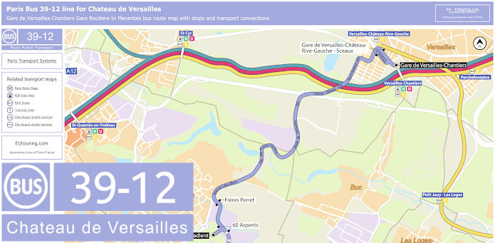
Paris bus 39-12 map for Gare de Versailles-Chantiers to Merantais with stops, connections and street plan
So here we have the maps and timetables for bus line 39-12 run by the transport company Savac that goes from Gare de Versailles Chantiers to Merantais within the commune or area of Magny-les-Hameaux and with several bus stops on route including Gare de Versailles Rive Gauche, yet we would like to point out that some stops are only served in a particular direction or at specific times just like if you were thinking of how to get to Golf National.
Paris bus line 39-12 stops:
Gare de Versailles Chantiers - Gare Routiere, Gare de Versailles Chateau Rive Gauche - Sceaux, Freres Perret, Technocentre 60 Arpents* **, Technocentre Le Gradient, Technocentre l'Etang* **, Technocentre Trou Berger**, Villaroy Sud**, Golf National**, Merantais**.
* Stop served in a specific direction one way, but only at specific times in the opposite direction. ** Stop only served at specific times.
Paris bus line 39-12 main transport connections:
Train Lines: C, N, U. Bus Lines: 1, 2, 4, 6, 11, 13, 22, 24, 260, 261, 263, 264, 439, 440, Express 1, N145.
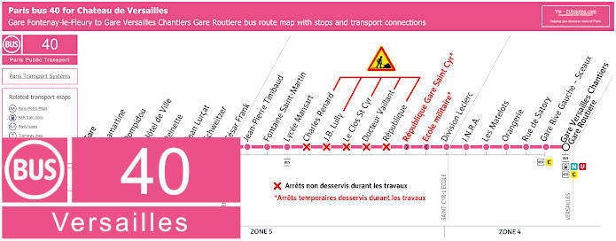
Paris bus 40 map for Gare Fontenay-le-Fleury to Gare Versailles Chantiers Gare Routiere with stops and transport connections
The bus line 40, which is run by the transport company Stavo, travels between Gare Fontenay-le-Fleury to Gare de Versailles Chantiers - Gare Routiere close to the famous palace, although the stop prior of Gare Rive Gauche - Sceaux is even closer, yet when you look at the timetables you will see that certain times are not served during specific holidays, although this bus route does operate daily throughout the year, even including the 1st May, which is a National French holiday.
Paris bus line 40 Versailles stops:
Fontenay-le-Fleury - Gare, Lamartine*, Pompidou*, Hotel de Ville, Reinette, Jean Lurcat, Schweitzer, Cesar Frank, Jean-Pierre Timbaud, Fontaine Saint-Martin, Lycee Mansart, Charles Renard, J.B. Lully, Le Clos St Cyr, Docteur Vaillant, Republique, Division Leclerc, I.N.R.A., Les Matelots, Orangerie, Rue de Satory, Gare Versailles Chateau Rive Gauche - Sceaux, Gare de Versailles Chantiers - Gare Routiere.
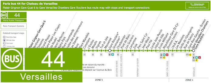
Paris bus 44 map for Plaisir Grignon Gare Quai 6 to Gare Versailles Chantiers Gare Routiere with stops and connections
Whereas the bus route 44, also operated by the transport company Stavo within the Paris region of Ile de France, travels from Plaisir, Plaisir-Grignon Gare Quai 6 to Versailles, Gare de Versailles Chantiers - Gare Routiere, travelling through other communes or areas of Les Clayes-sous-Bois, Fontenay-le-Fleury and Saint-Cyr-l'Ecole, yet we would like to point out certain stops are direction dependant or change during market day on a Sunday, plus some times are not served during holidays.
Paris bus line 44 Versailles stops:
Plaisir Grignon Gare Quai 6, Berthelot, Ebisoires, Grand Plaisir*, Gare Plaisir-Les Clayes*, Ida Nudel, Henri Barbusse, Alpha Park, Place Gourmande, Vallee des entrepreneurs, Les Dames, Avre, Place Mandela, Cimetiere, L'Enclos, Moulin, Vignes, Toit et Joie, Massenet, Gare Routiere**, Grainetier**, Charbonnier, Pont de Biais, Les Graviers, Lamartine, Zola, Parc Saint Cyr, Jean Mace*, Paul Fle, Lycee Jean Perrin, Hotel de Ville, Ecole Militaire*, Republique Gare St Cyr*, Division Leclerc, I.N.R.A., Les Matelots, Grille de l'Orangerie, Rue de Satory, Gare de Versailles Chateau Rive Gauche - Sceau, Gare Versailles Chantiers - Gare Routiere.
* Stop served in a specific direction. ** From 6am to 3pm on a Sunday due to the local market the Grainetier stop is not serviced and the Gare Routiere bus stop moves to Avenue du Bois.
Paris bus line 44 Versailles main transport connections:
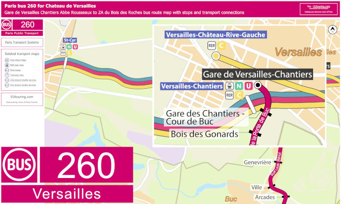
Paris bus 260 map for Gare de Versailles Chantiers to ZA du Bois des Roches with stops and transport connections
Yet here you have the maps and timetables for the bus line 260 run by the transport company Savac that goes from Gare de Versailles Chantiers - Abbe Rousseau to Magney-les-Hameaux - ZA du Bois des Roches, although, as you can see, there are some bus stops on route that are only served at specific times, with many stops not served during peak hours to make the journey far quicker.
Paris bus line 260 Versailles stops:
Gare de Versailles Chantiers - Abbe Rousseau, Gare de Versailles Chantiers - Cour de Buc, Bois des Gonards*, Cerf Volant*, Sente du Haras*, Genevriere*, Ville*, Arcades*, Bleriot - Jean Casale*, Croix Blanche, Trou Sale, Mare Chevalier, Centre, La Perruche*, Place*, Genevieve Aube*, ZA du Bois des Roches.
* Only served at certain times.
Paris bus 260 Versailles main transport connections:
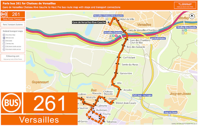
Paris bus 261 map for Gare de Versailles Chateau Rive Gauche to Haut Pre with stops and transport connections
This is the Savac bus line 261 travelling between the communes of Versailles and Buc, with the bus route going from Gare de Versailles Chateau Rive Gauche to Haut Pre, however, we would like to point out that when you look at the maps and timetables you will see some stops are only served in a particular direction or at certain times.
Paris bus line 261 Versailles stops:
Gare de Versailles Chateau Rive Gauche, Hotel de Ville, Gare de Versailles Chantiers - Etats Generaux, Gare des Versailles Chantiers - Cour de Buc, Bois des Gonards, Cerf Volant, Sente du Haras, Genevriere, Ville, Arcades, Bleriot - Jean Casale, Chateau-Massotte*, Chateau*, Massotte*, MLK / LFA, Calmette, Morane Saulnier**, Audemars**, Fourny**, Tabuteau**, Roland Garros**, Morane Saulnier**, Fort de Buc, Buccolines, Haut Pre.
* Only served in a specific direction. ** Only served at specific hours.
Paris bus 261 Versailles main transport connections:
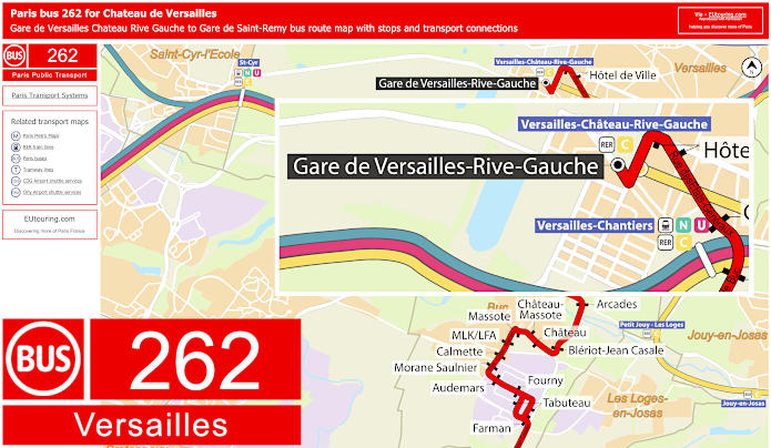
Paris bus 262 map for Gare de Versailles Chateau Rive Gauche to Gare de Saint-Remy with stops and transport connections
However, the bus line 262 travels between Gare de Versailles Chateau Rive Gauche and Gare de Saint-Remy-les-Chevreuse with many bus stops in between including another train station close to the former royal castle of Versailles called the Gare de Versailles Chantiers.
Paris bus line 262 Versailles stops:
Gare de Versailles Chateau Rive Gauche, Hotel de Ville, Gare de Versailles Chantiers - Etats Genereaux, Gare des Chantiers - Cour de Buc, Cerf Volant, Bois des Gonards, Cerf Volant, Sente du Haras, Genevriere, Ville, Arcades, Bleriot - Jean Casale, Chateau-Massotte, LFA - MLK, Calmette, Morane Saulnier, Audemars, Fourny, Tabuteau, Farman, Trou Sale, Mare Chevalier, Centre, La Perruche, Place, Le Thuit, Route de Chevreuse, Trinite, Boulangerie, Joseph Lemarchand, Victor Hugo, Le Buisson, 25 Arpents, Cabane, Beauplan, Les Pres, Place du 14 Juillet, Gare de Saint-Remy.
Paris bus 262 Versailles main transport connections:
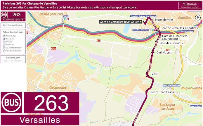
Paris bus 263 map for Gare de Versailles Chateau Rive Gauche to Gare de Saint-Remy with stops and transport connections
Although the Bus 263 is like an express service that only operates during peak hours on a Monday to Friday, except for French holidays, so as you can see, of a morning the bus route goes from Gare de Saint-Remy-les-Chevreuse to Gare de Versailles Chateau Rive Gauche, with the opposite direction leaving the Gare de Versailles Rive Gauche train station served between just after 4pm to 8pm.
Paris bus line 263 Versailles stops:
Gare de Versailles Chateau Rive Gauche, Hotel de Ville, Gare de Versailles Chantiers - Etats Generaux, Gare des Chantiers - Cour de Buc, Bois des Gonards, Cerf Volant, Ville, Bleriot - Jean Casale, Trou Sale, Le Thuit, Trinite, Boulangerie, Le Buisson, Beauplan, Gare de Saint-Remy.
Paris bus 263 Versailles main transport connections:
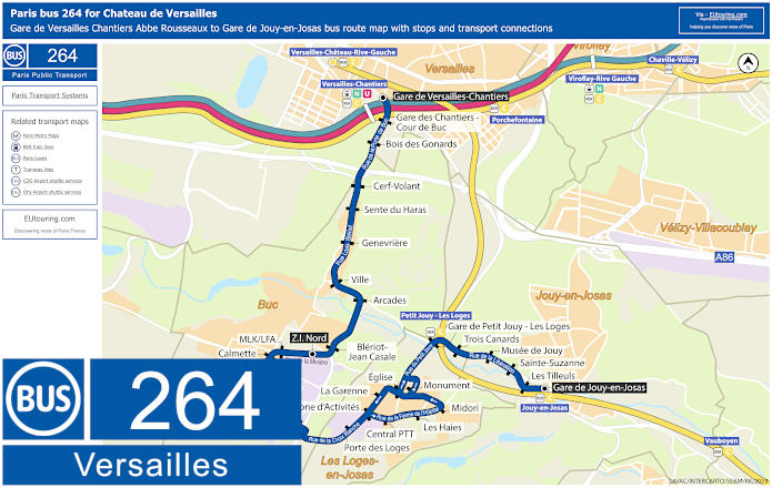
Paris bus 264 map for Gare de Versailles Chantiers to Gare de Jouy-en-Josas with stops and transport connections
The Savac bus line 264 for the Versailles area that operates on a Monday to Friday except for National French holidays between Gare de Versailles Chantiers to Gare de Jouy-en-Josas, but please take note of the map and timetables as certain bus stops are only served in a particular direction or at specific times.
Paris bus line 264 Versailles stops:
Gare de Versailles Chantiers - Abbe Rousseaux, Gare de Versailles Chantiers - Cour de Buc, Bois des Gonards***, Cerf Volant***, Sente du Haras***, Genevriere***, Ville***, Arcades***, Bleriot - Jean Casale***, ZI Nord, MLK / LFA, Calmette, Morane Saulnier, Roland Garros, Farman, Porte des Loges*, Zone d’Activites, La Garenne*, Central PTT**, Les Haies**, Midori**, Monument*, Eglise, Gare de Petit-Jouy - Les Loges, Trois Canards, Musee de Jouy, Sainte-Suzanne, Les Tilleuls, Gare de Jouy-en-Josas.
* Only served in direction of Gare de Versailles Chantiers. ** Only served in direction of Gare de Jouy-en-Josas. *** Stops only served during specific times.
Paris bus 264 Versailles main transport connections:
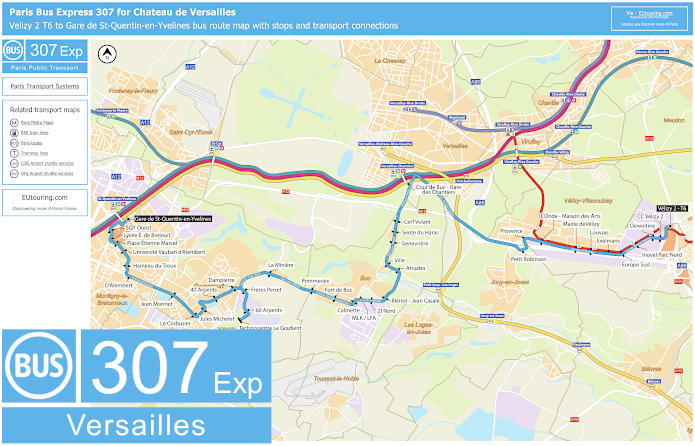
Paris bus express 307 map Velizy 2 T6 to Gare de St-Quentin-en-Yvelines with stops and transport connections
Whereas here we have the bus express 307 that travels between Velizy 2 - T6 and Gare de St-Quentin-en-Yvelines, and as you probably gathered from the maps and timetables, this is another bus route showing how to get to Chateau de Versailles, as it has a stop at Cour de Buc - Gare des Chantiers, but there are certain other bus stops only served at specific times.
Paris Bus Express 307 stops:
Gare de St-Quentin-en-Yvelines, SQY Ouest, Lycee E. de Breteuil*, Place Etienne Marcel, Universite Vauban-d'Alembert, Hameau de Troux, D'Alembert**, Jean Monnet, Le Corbusier, Jules Michelet, 40 Arpents, Dampierre, Freres Perret***, Technocentre 60 Arpents***, Technocentre Le Gradient***, La Miniere, Pommeraie, Fort de Buc, Calmette, MLK/LFA*, ZI Nord, Bleriot - Jean Casale, Arcades, Ville, Genevriere, Sente du Haras, Cerf Volant, Gare de Chantiers - Cour de Buc*, Petit-Robinson**, Provence*, L'Onde - Maison des Arts, Mairie de Velizy, Louvois, Exelmans*, Europe Sud, Inovel Parc Nord, Dewoltine, Centre Commercial Velizy 2, Velizy 2 - T6.
* Served in the direction of Gare de Saint-Quenitn-en-Yvelines. ** Served in the direction of Velizy 2 - T6. *** Only served at specific hours.
Paris Bus Express 307 main transport connections:
Train lines: C, N, U. Tram line: T6.
Paris Bus Express 307 Versailles route maps available:
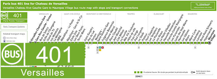
Paris bus 401 map for Versailles Chateau Rive Gauche Gare to Maurepas Village with stops and transport connections
Although this shows the map and timetables for the bus line 401 run by the transport company SQYBUS that travels between Versailles Chateau Rive Gauche Gare and Maurepas Village, which operates on a Monday to Saturday except for National French holidays, and you will see that some stops are only served in a particular direction or only during specific hours.
Paris bus line 401 Versailles stops:
Versailles chantiers Gare, Gare Rive Gauche - Sceaux, Eveche***, Ecole Bizet***, Rue du Plateau***, Rue Henri Barbusse***, Les Cottages* ***, Rue de Satory, Grille de l'Orangerie, Stand de Tir, Les Matelots, La Menagerie, INRA, Republique - La Poste*, Republique - Gare de St-Cyr**, Les Deux Ponts, Terrier Blanc, Saint-Exupery, Pas du Lac, Denton, Montigny - Saint-Quentin Gare, Fulgence Bienvenue, Etienne Marcel, Place Claudel, Jean Marechal, Cite Million**, La Fourche, Republique P.V. Couturier, Hotel de Ville, Yves Farge, Paul Langevin, Le Stade, Pasteur, Youri Gagarine, Les Templiers, La Passerelle, Les Reaux, La Petite Villedieu, Nouvelle Amsterdam, Franche-Comte Bourgogne, Les Pyramides, Lycee des Sept Mares, Normandie, Les Gatines, Bearn, Marie Curie, Gutenberg, Lavoisier, Rond-Point Schwartz, Hypermarche, Maurepas - Village.
* Only served in the direction of Maurepas Village. ** Only served in the direction of Versailles Chateau - Rive Gauche Gare. *** Stop not served during specific hours.
Paris bus 401 Versailles main transport connections:
Train lines: C, N, U. Tram Line: T13 Bus Lines: 1, 2, 3, 10, 11, 13, 22, 39.12, 40, 44, 103, 261, 262, 263, 401, Express 1, N145.
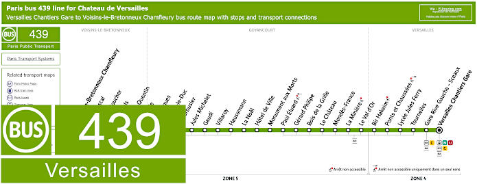
Paris bus 439 map for Versailles Chantiers Gare to Voisins-le-Bretonneux Chamfleury with stops and transport connections
The bus line 439 is also run by SQYBUS and travelling between Voisins-le-Bretonneux Chamfleury and Versailles Chantiers Gare, you will see from the route map and timetables that there is also a bus stop at Gare Rive Gauche - Sceaux, which is also within walking distance of the Chateau de Versailles, although some other stops are not wheelchair accessible.
Paris bus line 439 Versailles stops:
Voisins-le-Bretonneux Chamfleury, Blaise Pascal, Helene Boucher, Les Tilleuls, Le Val St-Quentin, Grande Ile, Les Portiques, E. Viollet-le-Duc, Le Corbusier, Jules Michelet, Gaudi, Villaroy, Haussmann, La Noel, Hotel de Ville, Monument aux Morts, Paul Eluard, Gerard Philipe, Bois de la Grille, Le Chateau, Mendes-France, La Miniere, Le Val d'Or, Bir-Hakeim, Ponts et Chaussees, Lycee Jules Ferry, Tournelles, Gare Rive Gauche - Sceaux, Versailles Chantiers Gare.
Paris bus 439 Versailles main transport connections:
Train lines: C, N, U. Bus lines: 1, 2, 3, 4, 10, 11, 13, 22, 39.12, 40, 44, 103, 261, 262, 263, 401, 439, 440, Express 1, N145.
Paris bus 440 map from Versailles Chantiers Gare to Montigny-le-Bretonneux with stops and transport connections
Yet the bus map and timetables for bus line 440 shows this particular route going from Versailles Chantiers Gare to Voisins-le-Bretonneux Chamfleury although at certain hours this continues its journey to Montigny-le-Bretonneux Lycee Descartes but only operates on a Monday to Friday in the early morning and early evening.
Paris bus line 440 Versailles stops:
Montigny-le-Bretonneux - Lycee Descartes*, Mare Caillon*, Michel Ange*, Avenue du Lycee*, Plan de l'Eglise*, Voisins-le-Bretonneux - Chamfleury, Blaise Pascal, Helene Boucher, Tilleuls, Le Val St-Quentin, Grande Ile, Les Portiques, E. Viollet-le-Duc, Le Corbusier, Jules Michelet, Gaudi, Villaroy, Haussmann, Dampierre, La Miniere, Le Val d'Or, Bir Hakeim, Ponts et Chaussees, Lycee Jules Ferry, Tournelles, Gare Rive Gauche - Sceaux, Versailles Chantiers Gare.
* Only served at specific times.
Paris bus 440 Versailles main transport connections:
Train lines: C, N, U. Bus lines: 1, 2, 3, 4, 10, 11, 13, 22, 39.12, 40, 44, 103, 261, 262, 263, 401, 439, 440, Express 1, N145.
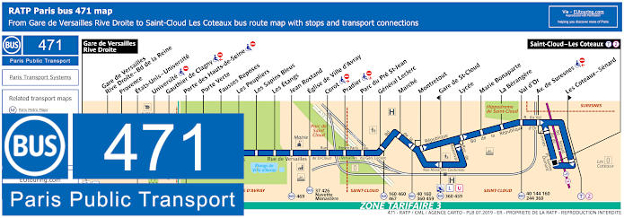
RATP Paris bus line 471 with stops, connections and street plan
So here we have the maps and timetables for the Paris bus line 471 that travels from Saint-Cloud - Les Coteaux to Gare de Versailles Rive Droite train station, with the bus route operating all year round, yet as you will see, there are certain bus stops that are not wheelchair friendly or only served in a particular direction.
Paris bus line 471 stops:
Gare de Versailles Rive Droite, Gare de Versailles River Droite - Bd de la Reine, Provence, Etata-Unis - Universite, Universite**, Gauthier de Clagny**, Porte des Hauts-de-Seine**, Porte Verte, Fausses Reposes, Les Peupliers, Les Sapins Bleus, Les Etangs, Jean Rostand, Eglise de Ville d'Avray, Corot**, Pradier**, Parc du Pre St-Jean, General Leclerc, Marche, Montretout, Gare de St-Cloud*, Lycee, Marie Bonaparte, La Berangere, Val d'Or, Avenue de Suresnes**, Les Coteaux - Senard*, Saint-Cloud - Les Coteaux.
* Stop is only served in a certain direction. ** Stop not accessible to those with reduced mobility.
Paris bus line 471 main transport connections:
Train Lines: L, U. Tram Line: T2. Bus Lines: 17, 37, 40, 111, 144, 160, 244, 360, 426, 459, 460, 467, 469, A, D, E, G, H, HEX, Navette Monastere (572), TEX, TRI, U.
Chateau de Versailles plans of Palaces, gardens, museum and public services
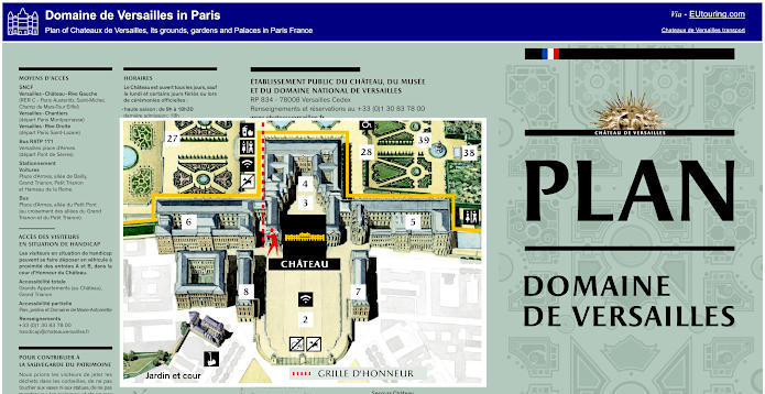
Plan of Domaine de Versailles in Paris showing Chateau de Versailles its grounds, gardens and public services
This map shows a plan of the layout for Chateau de Versailles, which provides information on the castle itself, access points, where all the key features of the Versailles domaine are located along with a guide to the walking distances from the Versailles palace to areas such as the Trianon and Marie-Antoinette's domaine that is around 1500 metres to reach that section or 3500 metres to reach the end of the Grand Canal for instance.
We would, however, like to point out that although entering the main grounds of Chateau Versailles is usually free, on days of the Musical Fountain Shows or the Musical Garden events, you have to purchase a ticket just for this or another classed as a Passport ticket, which will then enable you to enjoy these events along with the Grand Apartments, Hall of Mirrors, the Trianon and much, much more.
Purchasing different tickets for Chateau de Versailles directly:
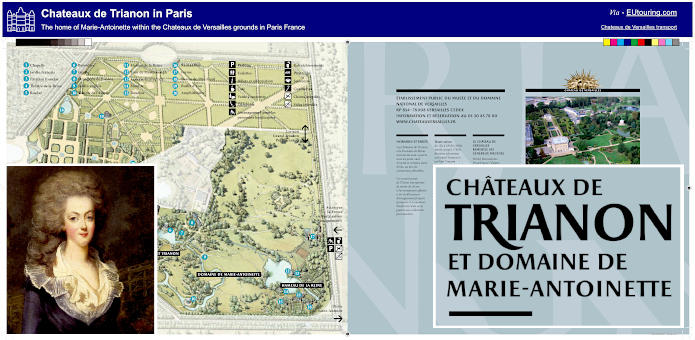
Plan of Chateaux de Trianon and its grounds once the home of Marie-Antoinette
Here you can see a plan of the Chateaux de Triannon and the domaine of Marie-Antoinette, which has a vast amount to discover, and to experience this area of the Versailles estate with the Grand Trianon and Petit Trianon, not forgetting the gardens and Queen's hamlet, you have to purchase a ticket that incorporates this.
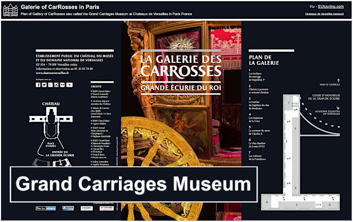
Plan of the Grand Carriages Museum at Chateau de Versailles
Whereas here you can see a plan and guide for The Coach Gallery, or the Grand Carriages museum, and the Great Stables of the King, which in French is La Galerie des Carrosses et Grande Ecurie du Roi, and as you can tell, this is right by the Place d'Armes in front of the Chateau de Versailles. This is also home to the Academy of Equestrian Arts created by Bartabas, where you can even enjoy a show during certain weekends for an additional charge when they are not on tour.