Paris tramway maps with stops, transport connections, tarif zones and tram timetables


Paris and the Ile de France region has a tramway network, which was originally first introduced in the 1850s, yet ceased operations a century later, however there is a new generation of tramways that first went into operation in 1992.  And as off 2019 it encompasses 10 tram lines with over 180 stations run by RATP, and this is soon to become the third largest tram network in Europe, which currently makes over 800,000 journeys every day, yet there is now two lines, the T4 and T11, that are run by SNCF, and there are more lines plus more stops planned for the future.

Paris tramway maps |  Tram T1  |  Tram T2  |  Tram T3a  |  Tram T3b  |  Tram T4  |  Tram T5  |  Tram T6  |  Tram T7  |  Tram T8  |  Tram T9  |  Tram T11  |  Tram T13  |  Funicular  |  Tramway Overview  |

Paris tramway overview map with station stops and main transport connections

Paris tramway map of lines with stops and connections
Here you can see a map showing the Paris Tramway with its various tram lines, being 10 in total, with many of the tram stations having transport connections to other public transport such as Metro and trains, and you will find that most of the tram system operates from the outskirts of the city going into the Paris region in addition to the fact that the trams are accessible to those with reduced mobility, as are the majority of the stations on this particular form of transport.

Paris tramway overview maps available:


Paris Tramway map - PDF (7.667 MB - with links to all tram line maps)
Paris Tramway map - Image (3.996 MB)

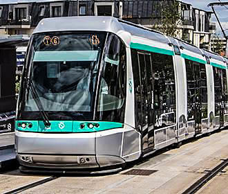
Paris tram line T1 map with tramway stations, transport connections and zones

Paris tram T1 map with stations, connections and zones
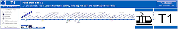
This map shows the Paris tram line T1 that travels between Asnieres Quatre Routes and Gare de Noisy-le-Sec and covers additional tram station stops like the Bodigny-Pablo Picasso, Liberation, Hopital Avicenne, La Courneuve - 8 Mai 1945, Hotel de Ville de la Courneuve, Basilique de Saint-Denis, Marche de Saint-Denis, Gennevilliers - Gare and La Noue, to name a few.

Paris tram line T1 stops:


Asnieres Quatre Routes, Les Courtilles, Le Luth, Le Village, Timbaud, Gare de Gennevilliers, Parc des Chanteraines, Chemin des Reniers, La Noue, Mairie de Villeneuve-la-Garenne, L’Ile Saint-Denis, Gare de Saint-Denis, Theatre Gerard Philipe, Marche de Saint-Denis, Basilique de Saint-Denis (Hotel de Ville), Cimetiere de Saint-Denis (Sous-Prefecture), Hopital Delafontaine, Cosmonautes, La Courneuve - Six Routes, Hotel de Ville de La Courneuve, Stade Geo Andre, Danton, La Courneuve - 8 Mai 1945, Maurice Lachatre, Drancy - Avenir, Hopital Avicenne, Gaston Roulaud, Escadrille Normandie-Niemen, La Ferme, Liberation, Hotel de Ville de Bobigny (Maison de la Culture), Bobigny - Pablo Picasso (Prefecture - Hotel du Departement), Jean Rostand, Auguste Delaune, Pont de Bondy, Petit Noisy, Gare de Noisy-le-Sec.

Paris tram line T1 main transport connections:


Metro Lines: 7, 13.
Train Lines: C, D, E, H.
Tram Lines: T5, T8.

Paris tram T1 route maps available:


Tram Line T1 map - PDF (standard quality - 0.319 MB)
Tram Line T1 map - PDF (high quality - 0.787 MB)
Tram Line T1 map - Image (standard quality - 0.279 MB)
Tram Line T1 map - Image (high quality - 0.599 MB)

Paris tram T1 timetables:


Tram Line T1 timetables - PDF (0.539 MB)
Tram Line T1 timetables - Image (1.501 MB)

Paris tram line T2 map with tramway stations, transport connections and zones

Paris tram T2 map with stations, connections and zones
This next map shows the Paris tram line T2 that travels between Pont de Bezons and Porte de Versailles and covers additional tram station stops like the Suzanne Lenglen, Issy - Val de Seine, Musee de Sevres, Parc de St-Cloud, Suresnes Longchamp, Puteaux, Charlebourg, La Defense and Parc Pierre Lagravere, to name a few.

Paris tram line T2 stops:


Pont de Bezons, Parc Pierre - Lagravere, Victor Basch, Jacqueline Auriol, Charlebourg, Les Fauvelles, Faubourg de l'Arche, La Defense (Grande Arche), Puteaux, Belvedere, Suresnes - Longchamp, Les Coteaux, Les Milons, Parc de St-Cloud, Musee de Sevres, Brimborion, Meudon-sur-Seine, Les Moulineaux, Jacques-Henri Lartigue, Issy - Val de Seine, Henri Farman (Porte de Seine), Suzanne Lenglen, Porte d’Issy, Porte de Versailles (Parc des Expositions).

Paris tram line T2 main transport connections:


Metro Lines: 1, 8, 9, 10, 12.
Train Lines: A, C, L, U.
Tram Line: T3a.

Paris tram T2 route maps available:


Tram Line T2 map - PDF (standard quality - 0.345 MB)
Tram Line T2 map - PDF (high quality - 0.844 MB)
Tram Line T2 map - Image (standard quality - 0.286 MB)
Tram Line T2 map - Image (high quality - 0.624 MB)

Paris tram T2 timetables:


Tram Line T2 timetables - PDF (0.513 MB)
Tram Line T2 timetables - Image (1.407 MB)
Paris tramway line T2

Paris tram line T3a map with tramway stations, transport connections and zones

Paris tram T3a map with stations, connections and zones
This map shows the Paris tram line T3a that travels between Pont du Garigliano and Porte de Vincennes and covers additional tram station stops like the Balard, Porte de Versailles, Porte de Vanves, Porte d'Orleans, Cite Universitaire, Porte d'Italie, Porte d'Ivry, Porte de Charenton and Porte Doree, to name a few.

Paris tram line T3a stops:


Pont de Garigliano (Hopital Europeen G. Pompidou), Balard, Desnouettes, Porte de Versailles (Parc des Expositions), Georges Brassens, Brancion, Porte de Vanves, Didot, Jean Moulin, Porte d’Orleans, Montsouris, Cite Universitaire, Stade Charlety (Porte de Gentilly), Poterne des Peupliers, Porte d’Italie, Porte de Choisy, Porte d’Ivry, Maryse Bastie, Avenue de France, Baron Le Roy, Porte de Charenton, Porte Doree, Montempoivre, Alexandra David-Neel, Porte de Vincennes.

Paris tram line T3a main transport connections:


Metro Lines: 1, 4, 7, 8, 12, 13, 14.
Train Lines: B, C.
Tram Lines: T2, T3b, T9.

Paris tram T3a route maps available:


Tram Line T3a map - PDF (standard quality - 0.327 MB)
Tram Line T3a map- PDF (high quality - 0.817 MB)
Tram Line T3a map - Image (standard quality - 0.287 MB)
Tram Line T3a map - Image (high quality - 0.616 MB)

Paris tram T3a timetables:


Tram Line T3a timetables - PDF (0.476 MB)
Tram Line T3a timetables - Image (1.329 MB)

Paris tram line T3b map with tramway stations, transport connections and zones

Paris tram T3b map with stations, connections and zones
Map showing the Paris tram line T3b that travels between Porte de Vincennes and Porte d'Asnieres - Marguerite Long and covers additional tram station stops like the Porte de Montreuil, Porte de Bagnolet, Porte des Lilas, Hopital Robert Debre, Porte de Pantin, Porte de la Villette, Canal Saint-Denis, Porte d'Aubervilliers, Diane Arbus, Porte de Clignancourt and Porte de Clichy to name a few.

Paris tram line T3b stops:


Porte de Vincennes, Porte de Montreuil, Marie de Miribel, Porte de Bagnolet, Severine, Adrienne Bolland, Porte des Lilas, Hopital Robert Debre, Butte du Chapeau Rouge, Porte de Pantin (Parc de la Villette), Delphine Seyrig, Ella Fitzgerald (Grands Moulins de Pantin), Porte de la Villette (Cite des Sciences et de l'Industrie), Canal Saint-Denis, Rosa Parks, Porte d’Aubervilliers, Colette Besson, Porte de la Chapelle, Diane Arbus (Porte des Poissonniers), Porte de Clignancourt (Puces de Saint-Ouen), Angelique Compoint (Porte de Montmartre), Porte de Saint-Ouen, Epinettes - Pouchet, Honore de Balzac, Porte de Clichy (Tribunal de Paris), Port d'Asnieres - Marguerite Long.

Paris tram line T3b main transport connections:


Metro Lines: 1, 3, 3bis, 4, 5, 7, 7bis, 9, 11, 12, 13, 14.
Train Lines: C, E.
Tram Line: T3a.

Paris tram T3b route maps available:


Tram Line T3b map - PDF (standard quality - 0.360 MB)
Tram Line T3b map - PDF (high quality - 0.916 MB)
Tram Line T3b map - Image (standard quality - 0.296 MB)
Tram Line T3b map - Image (high quality - 0.651 MB)

Paris tram T3b timetables:


Tram Line T3b timetables - PDF (0.485 MB)
Tram Line T3b timetables - Image (1.297 MB)
Paris tramway line T3B

Paris tram line T4 map with tramway stations and transport connections

Paris tram T4 map with stations and connections
This map shows the SNCF Paris tram line T4 that travels between Bondy and Aulnay sous Bois and covers additional tram station stops like the Les Coquetiers, Allee de la Tour Rendez-Vous, Les Pavillons sous Bois, Lycee Henri Sellier, Freinville Sevran and Rougemont Chanteloup, to name a few. The T4 tram line also covers an additional branch of the line that travels from Gargan to Hopital de Montfermeil, both of which cover ticket tariff zones 3 and 4.

Paris tram line T4 stops:


Bondy, La Remise a Jorelle, Les Coquetiers, Allee de la Tour Rendez-Vous, Les Pavillons sous Bois, Gargan, Lycee Henri Sellier, L'Abbaye, Freinville Sevran, Rougemont Chanteloup, Aulnay sous Bois, Republique Marx Dormoy, Leon Blum, Maurice Audin, Clichy sous Bois Mairie, Romain Rolland, Clichy Montfermeil, Notre Dame des Anges, Arboretum, Montfermeil Hopital.

Paris tram line T4 main transport connections:


Train Lines: B, E, K.

Paris tram T4 route maps available:


Tram Line T4 map - PDF (standard quality - 0.341 MB)
Tram Line T4 map - PDF (high quality - 0.816 MB)
Tram Line T4 map - Image (standard quality - 0.285 MB)
Tram Line T4 map - Image (high quality - 0.591 MB)

Paris tram T4 timetables:


Tram Line T4 timetables - PDF (0.908 MB)
Tram Line T4 timetables - Image (2.435 MB)

Paris tram line T5 map with tramway stations, transport connections and zones

Paris tram T5 map with stations, connections and zones
Map of Paris tram line T5 that travels between Marche de Saint-Denis and Garges Sarcelles and covers additional tram station stops like the Guynemer, Petit Pierrefitte, Mairie de Pierrefitte, Alcide d'Orbigny, Les Cholettes, Paul Valery etc.

Paris tram line T5 stops:


Marche de Saint-Denis, Baudelaire, Roger Semat, Guynemer (Stade Auguste Delaune), Petit Pierrefitte, Joncherolles, Suzanne Valadon, Mairie de Pierrefitte, Alcide d’Orbigny, Jacques Prevert, Butte Pinson (Parc Regional), Les Cholettes, Les Flanades, Paul Valery, Locheres, Garges Sarcelles.

Paris tram line T5 main transport connections:


Metro Line: 13.
Train Line: D.
Tram Line: T1.

Paris tram T5 route maps available:


Tram Line T5 map - PDF (standard quality - 0.286 MB)
Tram Line T5 map - PDF (high quality - 0.633 MB)
Tram Line T5 map - Image (standard quality - 0.235 MB)
Tram Line T5 map - Image (high quality - 0.492 MB)

Paris tram T5 timetables:


Tram Line T5 timetables - PDF (0.500 MB)
Tram Line T5 timetables - Image (1.340 MB)

Paris tram line T6 map with tramway stations, transport connections and zones

Paris tram T6 map with stations, connections and zones
This map shows the Paris tram line T6 that travels between Viroflay Rive Droite and Chatillon Montrouge and covers additional tram station stops like the Viroflay-Rive Gauche, Robert Wagner, Louvois, Velizy 2, Georges Pompidou, Hopital Beclere, Soleil Levant, Division Leclerc, Parc Andre Malraux etc.

Paris tram line T6 stops:


Viroflay - Rive Droite, Viroflay - Rive Gauche, Robert Wagner, L'Onde (Maison des Arts), Mairie de Velizy, Louvois, Inovel Parc Nord, Dewoitine, Velizy 2, Meudon-la-Foret, Georges Millandy, Georges Pompidou, Pave Blanc (Parc Noveos), Mail de la Plaine, Hopital Beclere, Soleil Levant, Division Leclerc, Parc Andre Malraux, Centre de Chatillon, Vauban, Chatillon Montrouge.

Paris tram line T6 main transport connections:


Metro line: 13.
Train lines: C, L, N.

Paris tram T6 route maps available:


Tram Line T6 map - PDF (standard quality - 0.300 MB)
Tram Line T6 map - PDF (high quality - 0.707 MB)
Tram Line T6 map - Image (standard quality - 0.263 MB)
Tram Line T6 map - Image (high quality - 0.561 MB)

Paris tram T6 timetables:


Tram Line T6 timetables - PDF (0.304 MB)
Tram Line T6 timetables - Image (0.880 MB)
Paris tramway line T6

Paris tram line T7 map with tramway stations, transport connections and zones

Paris tram T7 map with stations, connections and zones
Map showing the Paris tram line T7 that travels between Villejuif Louis Aragon and Athis-Mons - Porte de l'Essonne and covers additional tram station stops like the Lamartine, Bretagne, Porte de Thiais, Porte de Rungis, Robert Schuman, La Fraternelle, Caroline Aigie and Aeroport d'Orly, to name a few.

Paris tram line T7 stops:


Villejuif - Louis Aragon, Lamartine, Domaine Cherioux, Moulin Vert, Bretagne, Auguste Perret (Cimetiere Parisien), Porte de Thiais (Marche International), La Belle Epine, Place de la Logistique (Plateforme Sogaris), Porte de Rungis, Saarinen (Parc Silic Nord), Robert Schuman (Parc Silic Centre), La Fraternelle, Helene Boucher (Orlytech), Caroline Aigle (Orlyfret), Coeur d'Orly, Aeroport d'Orly, Athis-Mons - Porte de l'Essonne.

Paris tram line T7 main transport connections:


Metro Line: 7.
Train Lines: C, OrlyVal.
Bus Line: OrlyBus.

Paris tram T7 route maps available:


Tram Line T7 map - PDF (standard quality - 0.299 MB)
Tram Line T7 map - PDF (high quality - 0.689 MB)
Tram Line T7 map - Image (standard quality - 0.244 MB)
Tram Line T7 map - Image (high quality - 0.535 MB)

Paris tram T7 timetables:


Tram Line T7 timetables - PDF (0.471 MB)
Tram Line T7 timetables - Image (1.278 MB)

Paris tram line T8 map with tramway stations, transport connections and zones

Paris tram T8 map with stations, connections and zones
This map shows the Paris tram line T8 that travels between Epinay Orgemout, Saint-Denis Porte de Paris and Villetaneuse Universite as a branch and these cover additional tram station stops like the Epinay-sur-Seine - Gare, Rose Bertin, Les Mobiles, Cesar, Delaunay-Belleville, Saint-Denis - Gare, etc.

Paris tram line T8 stops:


Epinay Orgemont to Saint-Denis tram T8 stops:
Epinay Orgemont, Epinay-sur-Seine - Gare, Gilbert Bonne maison, Lacepede, Rose Bertin (Centre Commercial l'Ilo), Les Beatus, Les Mobiles, Blumenthal, Delaunay-Belleville, Paul Eluard, Saint-Denis - Gare, Pierre De Geyter, Saint-Denis - Porte de Paris.

Villetaneuse Uni to Saint-Denis tram T8 stops:


Villetaneuse Universite, Pablo Neruda, Jean Vilar, Cesar, Delaunay-Belleville, Paul Eluard, Saint-Denis - Gare, Pierre De Geyter, Saint-Denis - Porte de Paris.

Paris tram line T8 main transport connections:


Metro Line: 13.
Train Lines: C, D, H.
Tram Lines: T1, T11.

Paris tram T8 route maps available:


Tram Line T8 map - PDF (standard quality - 0.280 MB)
Tram Line T8 map - PDF (high quality - 0.613 MB)
Tram Line T8 map - Image (standard quality - 0.219 MB)
Tram Line T8 map - Image (high quality - 0.470 MB)

Paris tram T8 timetables:


Tram Line T8 timetables - PDF (0.788 MB)
Tram Line T8 timetables - Image (2.248 MB)

Paris tram line T9 map with tramway stations, transport connections and zones

Paris tram T9 map with stops and connections
Now this map shows the new 2021 Paris tram line T9 that travels between Porte de Choisy and Orly - Gaston Viens that is only around 5km form Orly Airport, plus you have additional tram station stops like La Briqueterie, Musee MAC VAL, Mairie de Vitry-sur-Seine, Rouget de Lisle, Four - Peary, Les Saules, etc.

Paris tram line T9 stops:


Porte de Choisy, Chateaudun - Barbe, Cimetiere Parisien d'Ivry (Place du General de Gaulle), La Briqueterie, Germaine Tailleferre, Beethoven - Concorde, Musee MAC VAL, Mairie de Vitry-sur-Seine, Camille Groult, Constant Coquelin, Watteau - Rondenay, Trois Communes, Verdun - Hoche, Rouget de Lisle, Carle - Darthe, Four - Peary, Christophe Colomb, Les Saules, Orly - Gaston Viens.

Paris tram line T9 main transport connections:


Metro Line: 7.
Train Line: C.
Tram Line: T3a.
Bus Lines: 103, 125, 132, 172, 180, 183, 185, 282, 323, 393, 482, 483, Choisybus (582), TVM (14).

Paris tram T9 route maps available:


Tram Line T9 map - PDF (standard quality - 0.510 MB)
Tram Line T9 map - PDF (high quality - 1.284 MB)
Tram Line T9 map - Image (standard quality - 0.369 MB)
Tram Line T9 map - Image (high quality - 0.791 MB)

Paris tram T9 timetables:


Tram Line T9 timetables - PDF (4.933 MB)
Tram Line T9 timetables - Image (8.176 MB)

Paris tram line T11 map with tramway stations, transport connections and zones

Paris tram T11 Express map with stations, connections and zones
The Paris tram line T11 Express travels between Epinay sur Seine and Le Bourget for easy connections to other transports, with five stops in between including Villetaneuse Universite, Pierrefitte Stains and Dugny La Courneuve.

Paris tram line T11 stops:


Epinay-sur-Seine, Montimagny - Epinay Villetaneuse, Villetaneuse Universite, Pierrefitte - Stains, Stains La Cerisaie, Dugny La Courneuve (Parc Georges Valbon), Le Bourget.

Paris tram line T11 main transport connections:


Train Lines: B, C, D, H.
Tram Line: T8.
Bus Lines: 11, 15, 37, 133, 143, 146, 150, 152, 237, 238, 249, 250, 253, 256, 268, 270, 337, 356, 361, 607, 609, 610, 703, N44, N51, Vitavil.

Paris tram T11 route maps available:


Tram Line T11 map - PDF (standard quality - 0.321 MB)
Tram Line T11 map - PDF (high quality - 0.715 MB)
Tram Line T11 map - Image (standard quality - 0.275 MB)
Tram Line T11 map - Image (high quality - 0.587 MB)

Paris tram T11 timetables:


Tram Line T11 timetables - PDF (0.780 MB)
Tram Line T11 timetables - Image (2.059 MB)

Paris tram line T13 map with tramway stations, transport connections and zones

Paris tram T13 map with stations, connections and zones
And then you have the Paris tram line T13 that travels between Saint-Germain en Laye to Saint-Cyr for easy connections to other main public transports options, that has ten stops in between including Camp des Loges, Mareil Marly, Saint-Nom la Breteche Foret de Marly, Bailly and Les Portes de Saint-Cyr to name a few.

Paris tram line T13 stops:


Saint-Germain en Laye, Camp des Loges, Lisiere Pereire, Fourqueux Bel Air, Mareil Marly, L'Etang Les Sablons, Saint-Nom la Breteche Foret de Marly, Noisy le Roi, Bailly, Allee Royale, Les Portes de Saint-Cyr, Saint-Cyr.

Paris tram line T13 main transport connections:


Train Lines: A, C, L, N, U.

Paris tram T13 route maps available:


Tram Line T13 map - PDF (standard quality - 0.287 MB)
Tram Line T13 map - PDF (high quality - 0.595 MB)
Tram Line T13 map - Image (standard quality - 0.205 MB)
Tram Line T13 map - Image (high quality - 0.390 MB)

Paris tram T13 timetables:


Tram Line T13 timetables - PDF (3.246 MB)
Tram Line T13 timetables - Image (7.990 MB)

Montmartre Funicular tramway map for Sacre Coeur Basilica

Montmartre Funicular tramway map Sacre Coeur Basilica
Here you can see a map showing the location of the Montmartre Funicular, spelt Funiculaire de Montmartre in French, which travels up the steep hill so you can avoid the many steps to reach Sacre Coeur Basilica, and although originally a cable system, the cars now travel independently, which is why this is often related to the Paris tramway system and works with the same Tram ticket tariff costs or Paris Metro tickets.

See more details, history and information on the Montmartre Funicular

Montmartre Funicular main transport connections within 550m:


Metro Lines: 2, 12.
Bus Lines: 40, 54, 85, N01, N02.

Paris Montmartre Funicular plans available:


Montmartre Funicular plan - PDF (with links to all transport maps)
Montmartre Funicular plan - Image
Paris tramway maps with stops and connections

Tram T1  |  Tram T2  |  Tram T3a  |  Tram T3b  |  Tram T4  |  Tram T5  |  Tram T6  |  Tram T7  |  Tram T8  |  Tram T9  |  Tram T11  |  Tram T13  |  Funicular  |  Tramway Overview  |