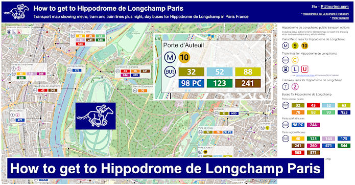
How to get to Hippodrome de Longchamp in Paris using public transport
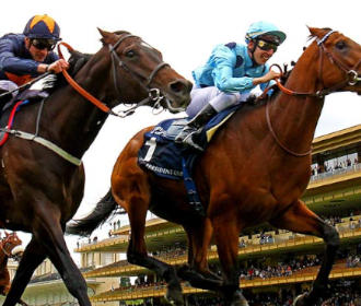
The Hippodrome de Longchamp is a famous French horse racecourse for flat racing, which plays host to the world renowned prestigious Qatar Prix de l'Arc de Triomphe horse racing event held each year, so below you can find out how to get to the Paris Hippodrome de Longchamp, also known as ParisLongchamp, for this and many other events, which includes route maps and timetables for public transport that can be downloaded by PDF or image formats for your home computer or mobile device.
Hippodrome de Longchamp transport map of Metro lines, trains, tramways, bus lines with stops, connections and street plan
Also known as ParisLongchamp, here you can see a street plan map showing the location of the horse racing course and the various transport options including Metro, tram and buses that will get you to the Hippodrome de Longchamp situated in the Bois de Boulogne in the 16th Arrondissement of Paris.
How to get to Hippodrome de Longchamp public transport maps available:
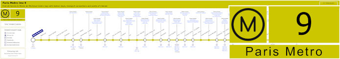
Paris Metro Line 9 map with stations, connections and points of interest
This shows the Paris Metro line 9, which goes between Pont de Sevres and Mairie de Montreuil, and as you can see there is a Metro stop on route called La Muette, which will get you within walking distance of the Hippodrome de Paris Longchamp or connecting with a bus to get you to another stop where a free shuttle operates on certain days.
Metro line 9 stops:
Pont de Sevres, Billancourt, Marcel Sembat, Porte de Saint-Cloud, Exelmans, Michel-Ange - Molitor, Jasmin, Ranelagh, La Muette, Rue de la Pompe, Trocadero, Iena, Alma - Marceau, Franklin D Roosevelt, Saint-Philippe-du-Roule, Miromesnil, Saint-Augustin, Havre - Caumartin, Chaussee d'Antin - La Fayette, Richelieu - Drouot, Grands Boulevards, Bonne Nouvelle, Strasbourg - Saint-Denis, Republique, Oberkampf, Saint-Ambrose, Voltaire, Charonne, Rue des Boulets, Nation, Buzenval, Maraichers, Porte de Montreuil, Robespierre, Croix de Chavaux, Mairie de Montreuil.
Metro line 9 main transport connections:
Metro Lines: 1, 2, 3, 4, 5, 6, 7, 8, 10, 11, 13, 14. Train Lines: A, C, E. Tram Lines: T2, T3b. Bus Line: RoissyBus.
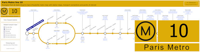
Paris Metro Line 10 map with stations, connections and points of interest
Here you can see the maps for Paris Metro line 10 that travels from Boulogne - Pont de Saint-Cloud to Gare d'Austerlitz Paris train station and to reach the Hippodrome de Longchamp the closest Metro station is the Porte d'Auteuil stop, which is located on the opposite side of the Bois de Boulogne to the horse racing course at a distance of around 2400 to 2800 metres depending on which way you walk.
However, you may be pleased to know that there is a Navette shuttle bus service from the bus station at Porte d'Auteuil on a Sunday and specific French holidays from 12:10pm returning from ParisLongchamp with a last departure time of 6:45pm, which is also ideal if you are thinking of a family outing to the Dimanche au Galop events.
Another free shuttle is provided for the JeuXdi evening racing experiences that also incorporate music DJs, food caterers, etc on certain Thursday evenings during the warmer months of the year, with the first departure from Porte d'Auteuil bus station (Gare Routiere in French) being 4:30pm and the last return departure time is 1am from the Hippodrome de Longchamp.
Metro line 10 stops:
Boulogne - Pont de Saint-Cloud, Boulogne - Jean Jaures, Porte d'Auteuil, Michel-Ange - Auteuil, Eglise d'Auteuil, Michel-Ange - Molitor, Chardon - Lagache, Mirabeau, Javel - Andre Citroen, Charles Michels, Avenue Emile Zola, La Motte-Picquet - Grenelle, Segur, Duroc, Vaneau, Sevres - Babylone, Mabillon, Odeon, Cluny - La Sorbonne, Maubert - Mutualite, Cardinal Lemoine, Jussieu, Gare d'Austerlitz.
Metro line 10 main transport connections:
Metro Lines: 4, 5, 6, 7, 8, 9, 10, 12, 13. Train Lines: B, C. Tram Line: T2.
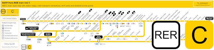
Yellow RER C train line map showing station stops, line branches, transport connections and zones
Whereas this is the RER C train line and as you can see from the maps, there are several different branches depending upon what direction you are travelling from, and the station you would need for Hippodrome de Longchamp is called Avenue Henri Martin, so you may need to head in the direction of St-Martin d'Etampes from one side of Paris or head towards Pontoise from the other side of Paris where you can see many popular tourist attractions listed like Musee d'Orsay.
Paris RER C train line stops:
Pontoise*, St-Ouen l'Aumone, St-Ouen l'Aumone - Liesse, Pierrelaye, Montigny Beauchamp, Francoville - Le Plessis-Bouchard, Cernay, Ermont Eaubonne, St-Gratien, Epinay-sur-Seine, Gennevilliers, Les Gresillons, St-Ouen, Porte de Clichy, Pereire Levallois, Neuilly - Porte Maillot (Palais des Congres), Avenue Foch, Avenue Henri Martin, Boulainvilliers, Avenue du Pdt Kennedy (Maison de Radio France), Champ de Mars (Tour Eiffel), Pont d'Iena, Invalides, Musee d'Orsay, St-Michel (Notre Dame), Paris Gare d'Austerlitz, Bibliotheque Francois Mitterrand, Ivry-sur-Seine, Vitry-sur-Seine, Les Ardoines, Choisy le Roi, Villeneuve le Roi, Ablon, Athis Mons, Juvisy, Savigny-sur-Orge, Epinay-sur-Orge, Ste-Genevieve des Bois, St-Michel-sur Orge, Bretigny, Marolles en Hurepoix, Bouray, Lardy, Chamarande, Etrechy, Etampes, St-Martin d'Etampes*, Versailles Chateau Rive Gauche*, Porchefontaine, Viroflay Rive Gauche, Chaville - Velizy, Meudon - Val Fleury, Issy, Issy - Val de Seine, Pont du Garigliano (Hopital Europeen Georges Pompidou), Javel, St-Quentin en Yvelines*, St-Cyr, Versailles Chantiers**, Petit Jouy les Loges, Jouy en Josas, Vauboyen, Bievres, Igny, Massy Palaiseau**, Massy Verrieres, Chemin d'Antony, Rungis La Fraternelle, Pont de Rungis (Aeroport d'Orly), Orly Ville, Les Saules, Longjumeau, Chilly Mazarin, Gravigny Balizy, Petit Vaux, La Norville (St-Germain les Arpajon), Arpajon, Egly, Breuillet (Bruyeres le Chatel), St-Cheron, Sermaise, Dourdan, Dourdan la Foret*.
* Terminus Points. ** RER C Transfer Points.
Paris RER C train line main transport connections:
Metro Lines: 1, 2, 3, 4, 5, 6, 8, 9, 10, 12, 13, 14. Train Lines: B, D, H, J, N, U, TGV, TER. Tram Lines: T1, T2, T3a, T3b, T6, T7, T8, T9, T11, T13. Bus Lines: 183, 393, PC (98), TVM (14).
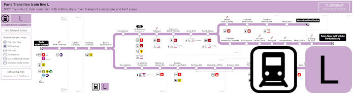
Transilien train line L map showing station stops, line branches, transport connections and zones
So here you can see the Transilien train line L maps, which travels from Paris Gare Saint-Lazare train station and branches off to various places in the Paris region, and for the Hippodrome de Longchamp you will need to head in the direction of Versailles Rive Droite or St-Nom la Breteche - Foret de Marly and alight at the train stop called Suresnes Mont Valerien.
Paris train line L stops:
Paris Saint-Lazare*, Pont Cardinet, Clichy Levallois, Asnieres sur Seine, Becon les Bruyeres, Courbevoie, La Defense (Grande Arche), Puteaux, Suresnes - Mont Valerien, Le Val d'Or, St-Cloud, Sevres - Ville d'Avray, Chaville Rive Droite, Viroflay Rive Droite, Montreuil, Versailles Rive Droite*, Garches - Marnes la Coquette, Vaucresson, La Celle St-Cloud, Bougival, Louveciennes, Marly le Roi, L'Etang la Ville, St-Nom la Breteche - Foret de Marly**, Noisy le Roi*, Mareil Marly, St-Germain en Laye - Bel Air Fourqueux, St-Germain en Laye G.C.*, Les Vallees, La Garenne Colombes, Nanterre Universite, Houilles - Carrieres sur Seine, Sartrouville, Maisons Lafitte, Acheres Ville, Conflans - Fin d'Oise, Neuville Universite, Cergy - Prefecture, Cergy - St-Christophe, Cergy le Haut*.
* Terminus Points. ** Train L Transfer Point.
Paris train line L main transport connections:
Metro Lines: 1, 3, 9, 12, 13, 14. Trian Lines: A, E, J, U, TER. Tram Lines: T2, T6, T13.
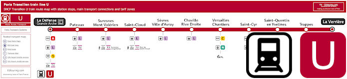
Transilien train line U map showing station stops, transport connections and zones
The Transilien train line U also stops at Suresnes Mont Valerien travelling between La Verriere and La Defense Grande Arche transport hub on the outskirts of Paris, and below you can see live train updates for departures and arrivals at Suresnes Mont Valerien, which is an approximate distance of 1800 metres from Paris Longchamp horserace course.
Paris train line U stops:
La Defense - Grande Arche*, Puteaux, Suresnes - Mont Valerien, St-Cloud, Sevres - Ville-d'Avray, Chaville Rive Droite, Versailles Chantiers, St-Cyr, St-Quentin en Yvelines, Trappes, La Verriere*.
* Terminus Points.
Paris train line U main transport connections:
Metro Line: 1. Train Lines: A, C, L, N, TER. Tram Line: T2.
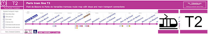
Paris tram line T2 map with tramway stations, transport connections and zones
Whereas these are the maps and timetables for the Paris tram line T2 going from Pont de Bezons to Porte de Versailles which is one of the transport options for Musee de Sevres and other tourist attractions. So, this is also how you can get to the Hippodrome de Longchamp, but located on the opposite side of the River Seine, you will find that the nearest T2 tram stop is called Suresnes Longchamp, which is approximately 1500 metres from the main entrance to this horserace course.
Paris tram line T2 stops:
Pont de Bezons, Parc Pierre - Lagravere, Victor Basch, Jacqueline Auriol, Charlebourg, Les Fauvelles, Faubourg de l'Arche, La Defense (Grande Arche), Puteaux, Belvedere, Suresnes - Longchamp, Les Coteaux, Les Milons, Parc de St-Cloud, Musee de Sevres, Brimborion, Meudon-sur-Seine, Les Moulineaux, Jacques-Henri Lartigue, Issy - Val de Seine, Henri Farman (Porte de Seine), Suzanne Lenglen, Porte d’Issy, Porte de Versailles (Parc des Expositions).
Paris tram line T2 main transport connections:
Metro Lines: 1, 8, 9, 10, 12. Train Lines: A, C, L, U. Tram Line: T3a.
Hippodrome de Longchamp Paris city central bus lines
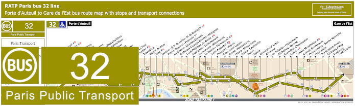
RATP Paris bus line 32 with stops, connections and street plan
The RATP bus line 32 travels from the Porte d'Auteuil to Gare de l'Est train station, also known as Paris Est, and as you can see from the maps and timetables the terminus point is right by the Metro station, which means you can take advantage of the free shuttle to Hippodrome de Longchamp on certain days, yet there are some stops on this bus route only served in a certain direction.
Paris bus line 32 stops:
Porte d'Auteuil, Gare d’Auteuil**, Alfred Capus, Raffet, Porte de Passy, Louis Boilly**, Avenue Ingres*, La Muette - Boulainvilliers, Passy - Boulainvilliers**, Place de Passy**, Place Possoz*, Jean Bologne**, La Tour*, Passy - La Tour**, Scheffer, Trocadero, Albert de Mun, Iena, Marceau - P. 1er de Serbie - Pl. de Beyrouth, Pierre Charron - Francois 1er, La Boetie - Champs-Elysees, Rd-Pt des Champs-Elysees - Matignon**, Saint-Philippe du Roule*, Matignon - Saint-Honore**, Haussmann - Miromesnil**, La Boetie - Miromesnil*, Saint-Augustin, Pasquier - Anjou*, Gare Saint-Lazare**, Rome - Haussmann*, Havre - Haussmann**, Havre - Caumartin*, Auber, Opera**, Chaussee d'Antin*, Choiseul**, Le Peletier - Haussmann*, Richelieu - Drouot**, Carrefour Chateaudun*, Cadet*, Square Montholon*, Grands Boulevards**, Poissonniere - Bonne Nouvelle**, Hauteville*, Porte Saint-Denis**, Chateau d’Eau**, Faubourg - Saint-Denis*, Gare de l'Est.
* Stop served in direction of Porte d'Auteuil. ** Stop served in direction of Gare de l'Est.
Paris bus line 32 main transport connections:
Metro Lines: 1, 3, 4, 5, 6, 7, 8, 9, 10, 12, 13, 14. Train Lines: C, E, J, L, P.
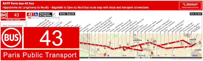
RATP Paris bus line 43 with stops, connections and street plan
Here we have the maps and timetables for RATP bus line 43, which travels from Gare du Nord train station to Neuilly - Bagatelle, but as you can see, on a Saturday and Sunday the route travels further with an additional four bus stops and a terminus point of the Hippodrome de Longchamp, which makes this one of the most convenient and closest bus routes to the flat racing course at a weekend, great for the Dimanche au Galop events.
Paris bus line 43 stops:
Hippodrome de Longchamp*, Longchamp - GoodPlanet**, Les Moulins - Camping* ***, Route des Moulins* ***, Parc de Bagatelle*, Neuilly - Bagatelle, Place de Bagatelle, Rue du Centre, Rue du Bois de Boulogne, Maurice Barres, Pont de Neuilly, General Gouraud, Rue de l’Eglise**, Sainte-Foy, Eglise Saint-Pierre, Chartres, Montrosier - Parmentier, General Koenig - Palais des Congres, Pereire - Porte Maillot, Eglise Saint-Ferdinand, Ternes - Mac-Mahon, Ternes, Hoch - Saint-Honore, Friedland - Haussmann, Haussmann - Courcelles, Haussmann - Miromesnil, Saint-Augustin - La Boetie***, Saint-Augustin**, Pasquier - Anjou***, Gare Saint-Lazare**, Gare Saint-Lazare - Havre***, Gare Saint-Lazare - Budapest***, Trinite, Saint-Georges - Chateaudun, Carrefour de Chateaudun, Chateaudun - Lamartine***, Cadet**, Maubeuge - Rochechouart***, Square Montholon**, Condorcet***, Magenta - Maubeuge***, Place Franz Liszt**, Lafayette - Magenta**, Gare du Nord - Dunkerque***, Gare du Nord.
* Stop only served on a Saturday and Sunday. ** Served in the direction of Gare du Nord. *** Served in the direction of Neuilly - Bagatelle / Hippodrome de Longchamp.
Paris bus line 43 main transport connections:
Metro Lines: 1, 2, 3, 4, 5, 7, 9, 12, 13, 14. Train Lines: B, C, D, E, J, L.
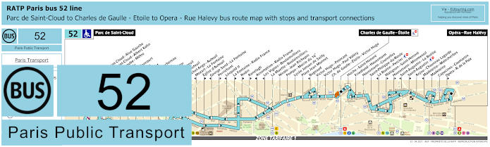
RATP Paris bus line 52 with stops, connections and route plan
The RATP bus line 52 travels from Opera - Rue Halevy to Parc de Saint-Cloud, but as you can see from the bus route maps and timetables, some stops are only served in a specific direction and there is only a partial service of an evening from Charles de Gaulle Etoile - Friedland going through to Porte d'Auteuil, which is actually the stop you would need for the Hippodrome de Longchamp in the Bois de Boulogne.
Paris bus line 52 stops:
Parc de Saint-Cloud, La Colline**, Pont de Saint-Cloud - Rive Gauche**, Pont de Saint-Cloud - Albert Kahn, Rhin et Danube - Metro, Rue de Silly, Rue de Billancourt, Jean Jaures, Rue de l’Est, Denfert-Rochereau, La Tourelle, Porte Molitor, Porte d’Auteuil***, Gare d’Auteuil, Michel-Ange - Auteuil, Mozart - La Fontaine*, Eglise d’Auteuil**, George Sand - La Fontaine*, Perrichont**, Leopold II*, La Fontaine - Radio France**, Rodin**, Ranelagh**, Assomption - Radio France*, Les Vignes - Boulainvilliers*, La Muette - Boulainvilliers, Nicolo - Jean Richepin, Pompe - Mairie du 16e, Lycee Janson de Sailly, Place Jean Monnet, Bugeaud, Victor Hugo - Poincare, Victor Hugo - Paul Valery, Charles de Gaulle - Etoile - Victor Hugo, Charles de Gaulle - Etoile - Friedland***, Hoche - Saint-Honore, Friedland - Haussmann, Haussmann - Courcelles, Saint-Philippe du Roule, La Boetie - Percier*, Matignon - Saint-Honore**, Haussmann - Miromesnil**, Saint-Augustin - La Boetie*, Saint-Augustin**, Anjou - Chaveau Lagarde, Madeleine - Malesherbes*, Madeleine, Capucines - Caumartin, Opera - Rue de la Paix**, Opera - Rue Halevy.
* Stop served in direction of Parc de Saint-Cloud. ** Stop served in direction of Opera - Rue Halevy. *** Only a partial service operates in the evening between Porte d'Auteuil and Charles de Gaulle Etoile - Friedland.
Paris bus line 52 main transport connections:
Metro Lines: 1, 2, 3, 6, 7, 8, 9, 10, 12, 13, 14. Train Lines: A, C. Tram Line: T2.
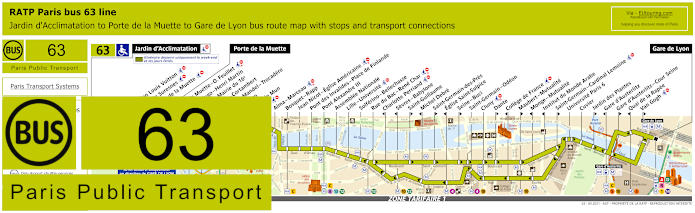
RATP Paris bus 63 map with stops, connections and street plan
Although here are the maps and timetables for the Paris bus line 63 that travels from Gare de Lyon to Porte de la Muette, which is actually the bus stop you would need for Paris Longchamp racecourse, yet please bear in mind that during weekends and holidays this bus route travels further on from Porte de la Muette to Jardin d'Acclimatation.
Paris bus line 63 stops:
Jardin d'Acclimatation*, Fondation Louis Vuitton*, Route de Suresnes*, Pelouse de la Muette*, Porte de la Muette, Pte de la Muette - Octave Feuillet, Victor Hugo - Henri Martin, Pompe - Mairie du 16e, Sablons - Cortambert, Georges Mandel - Trocadero, Trocadero, Albert de Mun, Iena, Alma - Marceau, Bosquet - Rapp, Jean Nicot - Eglise Americaine, Pont des Invalides - Place de Finlande, Pont Alexandre III, Assemblee Nationale, Lille - Universite, Solferino - Bellechasse, Rue du Bac - Rene Char, Charlotte Perriand***, Sevres - Babylone***, Saint-Guillaume**, Michel Debre***, Saint-Germain-des-Pres**, Eglise Saint-Sulpice***, Seine - Buci**, Saint-Germain - Odeon, Cluny, Dante**, College de France***, Maubert - Mutualite**, Monge - Mutualite***, Institut du Monde Arabe***, Saint-Germain - Cardinal Lemoine**, Universite Paris 6, Cuvier, Jardin des Plantes**, Gare d'Austerlitz***, Gare d'Austerlitz - Cour Seine**, Quai de la Rapee***, Van Gogh**, Gare de Lyon.
* Only served on weekends, French public holidays and during school holidays. ** Stop served in direction of Paris Gare de Lyon. *** Stop served in direction of Jardin d'Acclimatation and Porte de la Muette.
Paris bus line 63 main transport connections:
Metro lines: 1, 4, 5, 6, 8, 9, 10, 12, 13, 14. Train lines: A, C, D, R.
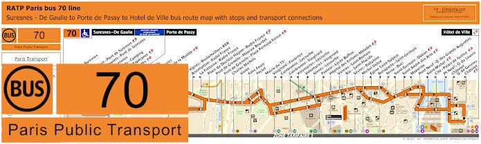
RATP Paris bus line 70 with stops, connections and route plan
Whereas the street maps and timetables for bus line 70 show this route travelling from the Paris Hotel de Ville through to Porte de Passy and further on to Suresnes - De Gaulle on a Monday to Friday, and you will find that on this extended section of the bus route there are two bus stops called Les Moulins - Camping and Allee de l'Esperance that will get you close to the ParisLongchamp horserace course.
Paris bus line 70 stops:
Suresnes - De Gaulle***, Mairie de Suresnes** ***, Henri IV** ***, Henri Sellier - Pont de Suresnes** ***, Rue des Bourets - Pont de Suresnes* ***, Pont de Suresnes** ***, Les Moulins - Camping***, Allee de l'Esperance***, Les Cascades***, Porte de Passy, Louis Boilly**, Avenue Ingres*, Chaussee de la Muette, Ranelagh*, Rodin*, Les Vignes - Boulainvilliers RER**, Assomption - Radio France**, La Fontaine - Radio France*, Place du Docteur Hayem - Radio France, Pont de Grenelle - Maurice Bourdet, Pont de Grenelle - Place Fernand Forest, Charles Michels, Violet, Felix Faure, Peclet, Mairie du 15e, Vaugirard - Favorites**, Cambronne - Lecourbe*, Cambronne - Vaugirard**, Volontaires - Lecourbe*, Volontaires - Vaugirard**, Sevres - Lecourbe, Pasteur - Lycee Buffon**, Hopital des Enfants Malades, Vaneau - Saint-Romain, Bac - Saint-Placide, Sevres - Babylone, Michel Debre, Eglise Saint-Sulpice*, Bonaparte - Saint-Germain**, Seine - Buci**, Saint-Germain - Odeon*, Saint Andre des Arts**, Mazarine*, Pont Neuf - Quai des Grands Augustins, Saint-Michel, Cite - Palais de Justice, Pt Neuf - Q du Louvre, Chatelet - Quai des Gesvres**, Chatelet*, Hotel de Ville.
* Served in Direction of Suresnes - De Gaulle or Porte de Passy. ** Served in direction of Paris Hotel de Ville. *** Only served on a Monday to Friday.
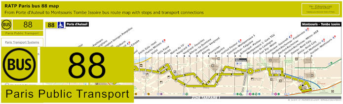
RATP Paris bus line 88 with stops, connections and street plan
Although, another option of getting to the Hippodrome de Longchamp and taking advantage of the free shuttle on a Sunday, French public holiday or for the JeuXdi events is by utilising the Paris bus line 88, which has a terminus point of Porte d'Auteuil where the Navette shuttle goes from to the horse racing course, and this RATP bus route 88 goes to stops such as Paris Denfert-Rochereau before terminating at Montsouris - Tombe Issoire.
Paris bus line 88 stops:
Porte d'Auteuil, Porte Molitor, Exelmans, Versailles - Exelmans, Pont du Garigliano, Hopital Europeen Georges Pompidou, Rue Leblanc, Leblanc - Delbarre, Place Balard, Parc Andre Citroen, Cauchy, Javel, Emile Zola - Javel, Charles Michels, Violet, Felix Faure, Peclet, Mairie du 15e, Vaugirard, Vaugirard - Favorites, Alleray–La Quintinie, Cambronne - Vaugirard, Alleray, Procession, Falguiere, Institut Pasteur, Cotentin - Montparnasse 3, Pasteur - Falguiere, Montparnasse 2 - Gare TGV, Place de Catalogne, Jean Zay - Maine, Froidevaux - Gassendi, Denfert-Rochereau - Froidevaux, Denfert-Rochereau, Denfert-Rochereau - Metro - RER, Dareau - Rene Coty, Alesia - Rene Coty, Parc Montsouris, Jourdan - Montsouris, Montsouris - Tombe Issoire.
Paris bus line 88 main transport connections:
Metro Line: 4, 6, 8, 9, 10, 12, 13. Train Lines: B, C, N. Tram Line: T3a.
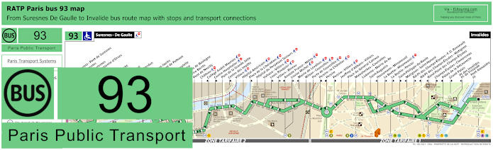
RATP Paris bus line 93 with stops, connections and street plan
So here you can see the RATP bus line 93 that travels from Suresnes De Gaulle to Invalides, which is one of the transport options for how to get to Les Invalides tourist attraction, but getting back to Hippodrome de Longchamp, as you can see from the maps and timetables, you would need to cross the Pont de Suresnes from the terminus to access the horserace course, home to the famous Prix de l'Arc de Triomphe yearly flat racing event.
Paris bus line 93 stops:
Suresnes - De Gaulle, Rue des Bourets - Pont de Suresnes, Pont de Suresnes, Mairie de Suresnes, Honore d'Estienne d'Orves, Henri IV, Jean Mace, Berty Albrecht, Pompidou, De Pressense, Residence Verdun, Bas Rogers, Wallace - Jean Jaures, Hopital - Pont de Puteaux, Bagatelle, Place de Bagatelle, Rue du Centre, Rue du Bois de Boulogne, Maurice Barres, Pont de Neuilly, Chateau, College Andre Maurois, Centre Hospitalier, Pont de la Grande Jatte, Centre des Impots, Villiers, Hopital Americain, Place de la Liberation, Hopital du Perpetuel Secours, Voltaire - Villiers, Louis Rouquier, Villiers - Bineau, Anatole France - Metro, Louise Michel, Mairie de Levallois, Wilson - Courcelles, Porte de Courcelles, Pereire - Le Chatelier, Pereire, Pereire - Villiers, Jouffroy d'Abbans - Villiers, Place du General Catroux, Malesherbes - Courcelles, Lisbonne - Mairie du 8e, Saint-Augustin, Haussmann - Miromesnil, La Boetie - Percier, La Boetie - Miromesnil, Saint-Philippe-du-Roule, Matignon - Saint-Honore, Rd-Pt des Champs-Elysees - F. D. Roosevelt, Rd-Pt des Champs-Elysees - Matignon, Rond-Point des Champs-Elysees, Champs-Elysees - Clemenceau, Palais de la Decouverte, Grand Palais, Pont des Invalides - Place de Finlande, Pont Alexandre III, Invalides.
Paris bus line 93 main transport connections:
Metro Lines: 1, 2, 3, 8, 9, 13. Train Line: C. Tram Line: T2.
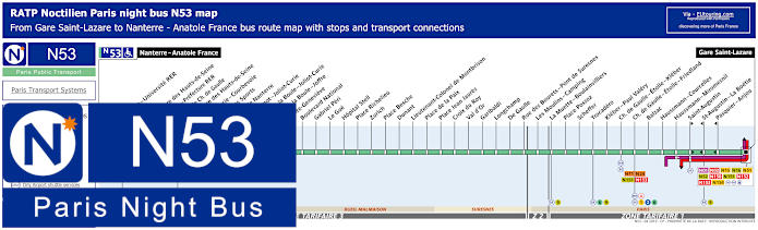
Paris Noctilien night bus N53 map with stops and transport connections
This shows the Noctilien line N53, which is a Paris night bus service that runs during the early hours when other transport finishes for the night, and when you look at the bus maps and timetables, you will see that there is a bus stop called Les Moulins - Camping, which is an approximate distance of around 500 metres from the Hippodrome de Longchamp flat racing horserace course.
Paris night bus line N53 stops:
Nanterre - Anatole France, Nanterre - Universite RER, Soufflot, Prefecture des Hauts-de-Seine, Nanterre - Prefecture RER, Esplanade Charles de Gaulle, Prefecture des Hauts-de-Seine, Joliot-Curie - Courbevoie, Palais des Sports, Mairie de Nanterre, Sadi Carnot - Joliot-Curie, Place de la Boule - Joliot-Curie, Place de la Boule - Joffre, Sainte-Genevieve, Boulevard National, Gabriel Peri, Le Gue, Hopital Stell, Place Richelieu, Zurich, Place Besche, Dunant, Lieutenant-Colonel de Montbrison, Place de la Paix, Place Jean Jaures, Croix du Roy, Val d’Or, Garibaldi, Longchamp, De Gaulle, Rue des Bourets - Pont de Suresnes, Les Moulins - Camping, La Muette - Boulainvilliers, Place Possoz, Scheffer, Trocadero, Kleber - Paul Valery, Charles de Gaulle - Etoile - Kleber, Charles de Gaulle - Etoile - Friedland, Balzac, Haussmann - Miromesnil, Saint-Augustin, Saint-Augustin - La Boetie, Pasquier - Anjou, Gare Saint-Lazare.
Paris night bus line N53 main transport connections:
Metro Lines: 1, 2, 3, 6, 9, 12, 13, 14. Train Lines: A, E, J, L. Bus lines: N01, N02, N11, N15, N16, N24, N51, N52, N150, N151, N152, N153, N154.
Hippodrome de Longchamp Paris city outskirts bus lines
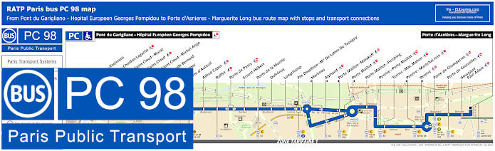
RATP Paris PC bus line 98 stops, connections and street plan
The bus line PC, sometimes referred to as bus line 98, travels between Pont du Garigliano - Hopital Europeen Georges Pompidou and Porte d'Asnieres - Marguerite Long, so when you look at the street maps and timetables you will see this is one of the transport options for Parc de Princes football stadium, plus other sports venues, which has a bus stop at the Porte d'Auteuil to reach the Hippodrome de Longchamp either via the free shuttle at specific times or by walking.
Paris PC bus line 98 stops:
Pont du Garigliano - Hopital Europeen Georges Pompidou, Versailles - Exelmans, Versailles - Chardon-Lagache, Porte de Saint-Cloud - Murat, Porte de Saint-Cloud*, Porte de Saint-Cloud - Michel Ange, Lycee Claude Bernard, Porte Molitor, Porte d'Auteuil, Alfred Capus, Raffet, Porte de Passy, Ernest Hebert, Porte de la Muette, Dufrenoy, Longchamp, Pte Dauphine - Mal De Lattre de Tassigny, Marbeau*, Alphand**, Porte Maillot - Malakoff*, Porte Maillot**, Porte Maillot - Pershing, Pereire - Porte Maillot, Ternes - Mac Mahon, Pereire - Marechal Juin*, Pereire**, Porte de Champerret, Porte de Courcelles, Gourgaud - Paul Adam, Porte d'Asnieres - Marguerite Long.
* Stop served in direction of Pont du Garigliano - Hopital Europeen Georges Pompidou. ** Stop served in direction of Porte d'Asnieres - Marguerite Long.
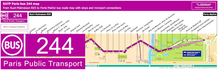
RATP Paris bus line 244 with stops, connections and street plan
Yet the RATP bus 244 is also another line that will get you close to the Hippodrome de Longchamp, which travels between Rueil-Malmaison RER and Porte Maillot, meaning this is one of the public transport options for Palais de Congres, but by alighting at the bus stop Les Moulins - Camping you will only have a short walk to the entrance of ParisLongchamp.
Paris bus line 244 stops:
Rueil-Malmaison RER, Colmar*, Les Martinets**, Baudin*, Genevieve Couturier**, Albert 1er - Rueil - Ville*, Rueil - Ville, Le Gue, Hopital Stell, Edmond Rostand, Les Godardes, Rue de la Paix, 8 Mai 1945, Les Houtraits, Place de la Paix, Place Jean Jaures, Croix du Roy, Val d'Or, Garibaldi, Suresnes - Longchamp, De Gaulle, Rue des Bourets - Pont de Suresnes, Les Moulins - Camping, Longchamp - GoodPlanet, Bagatelle - Pre Catelan, Route des Lacs***, Route de La Muette***, Porte de Madrid****, Fondation Louis Vuitton****, Jardin d'Acclimatation, Porte Maillot.
* Stop served in direction of Rueil-Malmaison RER. ** Stop served in direction of Porte Maillot. *** Served on a Monday to Friday. **** Served on Saturday, Sunday and French public holidays.
Paris bus line 244 main transport connections:
Metro Line: 1. Train Lines: A, C. Tram Line: T2. Bus Lines: 4E, 27, 40, 70, 73, 82, 93, 144, 158, 160, 241, 258, 259, 360, 367, 467, PC (98).
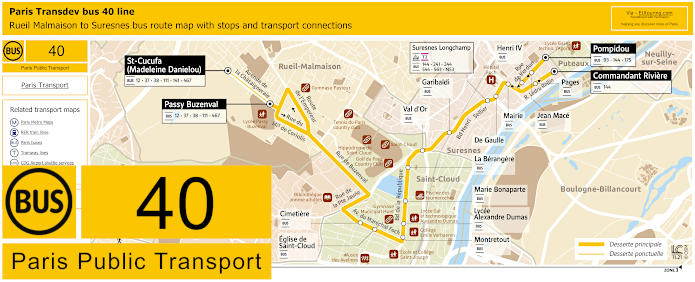
Paris Transdev bus line 40 Rueil Malmaison to Suresnes with stops, connections and street plan
Yet this is the bus line 40 run by the transport company Transdev that travels between the communes of Rueil-Malmaison and Suresnes, which at this stage we would like to point out is more of a school bus as it only runs at specific hours on a Monday to Friday during the academic year, although it does have a stop at Suresnes Longchamp T2 station for access to the Paris Tramway system and also getting to ParisLongchamp.
Paris Transdev bus line 40 stops:
St Cucufa (Madeleine Danielou)***, Passy Buzenval***, Cimetiere, Eglise de St Cloud, Montretout, Lycee Alexandre Dumas, Marie Bonaparte, La Berangere, Val d'Or, Garibaldi, Suresnes Longchamp Gare T2, De Gaulle, Henri IV*, Jean Mace*, Mairie**, Pages**, Pompidou*, Commandant Riviere**.
* Served in direction of St Cucufa or Passy Buzenval. ** Served in direction of Commandant Riviere. *** Only served at specific times.
Paris Transdev bus line 40 main transport connections:
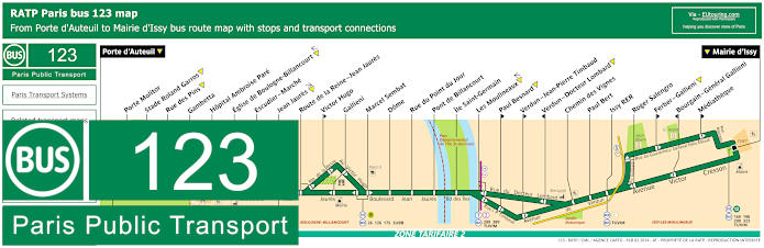
RATP Paris bus line 123 with stops, connections and street plan
The RATP Bus line 123 goes from Porte d'Auteuil to Mairie d'Issy and as you can see from the maps and timetables, this is one of the options for how to get to the Roland Garros tennis stadium, but getting back to the horse racing and ParisLongchamp, even though it is a good walk through the Bois de Boulogne, you can take advantage of the free shuttle from the Porte d'Auteuil bus station on certain days as we mentioned above.
Paris bus line 123 stops:
Porte d'Auteuil, Porte Molitor, Stade Roland Garros, Rue des Pins, Gambetta, Hopital Ambroise Pare, Eglise de Boulogne-Billancourt, Escudier - Marche, Jean Jaures, Route de la Reine - Jean Jaures, Victor Hugo**, Gallieni, Marcel Sembat, Dome, Rue du Point du Jour, Pont de Billancourt, Ile Saint-Germain, Les Moulineaux, Paul Besnard**, Verdun - Jean-Pierre Timbaud**, Verdun - Docteur Lombard*, Chemin des Vignes, Paul Bert, Issy RER, Roger Salengro, Ferber - Gallieni**, Bourgain - General Gallieni*, Mediatheque**, Mairie d'Issy.
* Stop served in direction of Porte d'Auteuil. ** Stop served in direction of Mairie d'Issy.
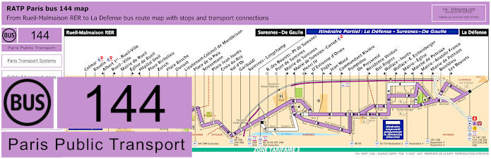
RATP Paris bus line 144 with stops, connections and street plan
This shows the street maps and timetables for the bus line 144 that travels between Rueil-Malmaison RER and Suresnes - De Gaulle or through to La Defense, although this latter part of the bus route is only a partial service, and for the ParisLongchamp horse racing course you would need the Suresnes - Longchamp or the Suresnes - De Gaulle bus stops.
Paris bus line 144 stops:
Rueil-Malmaison RER, Colmar, Baudin, Albert 1er - Rueil-Ville*, Rueil - Ville**, Mairie de Rueil, Eglise de Rueil**, Hopital Stell*, Place Richelieu, Zurich, Place Besche, Dunant, Lieutenant-Colonel de Montbrison, Place de la Paix, Stresemann, Place Jean Jaures, Croix du Roy, Val d'Or, Garibaldi, Suresnes - Longchamp, Suresnes - De Gaulle, R. des Bourets - Pont de Suresnes***, Pont de Suresnes***, Mairie de Suresnes**, Mairie de Suresnes - Carnot*, Henri IV** ***, D'Estienne d'Orves*, Pages**, Jean Mace*, Commandant Riviere**, Pompidou, De Pressense, Residence Verdun**, Bas Rogers, Wallace - Jaures*, Wallace - E. Eichenberger**, Marche de Puteaux*, Mairie - Eglise**, Mairie - Anatole France*, Mairie de Puteaux**, Boieldieu, Les Bouvets**, La Defense.
* Served in the direction of Rueil-Malmaison RER. ** Served in direction of La Defense. *** Only served at specific hours in Rueil-Malmaison RER direction.
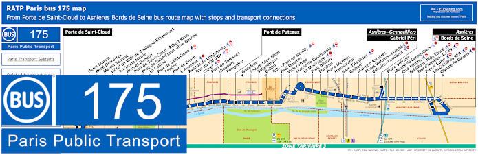
RATP Paris bus line 175 with stops, connections and street plan
So here we have the bus line 175 that travels between Asnieres - Bords de Seine and Porte de Saint-Cloud and although on the opposite side of the River Seine to the horserace course, you can alight the bus at the L'Aqueduc stop and cross the Passerelle de l'Avre or alternatively, you can take the Pont de Suresnes bus stop going over the bridge of the same name, both of which will get you within walking distance of the Hippodrome de Longchamp, but at well over 1200 metres.
Paris bus line 175 stops:
Porte de Saint-Cloud, Henri Martin, Rene Descartes, Marcel Sembat, Hotel de Ville de Boulogne-Billancourt, Ancienne Mairie, Rhin et Danube, Pont de Saint-Cloud - Albert Kahn, Pont de Saint-Cloud - Rive Gauche*, La Colline*, Parc de Saint-Cloud, Feudon, Parc de Bearn, L’ Aqueduc, Avenue de Longchamp, Rue du Val d’Or, Clavel, Pont de Suresnes, Nieuport, Pompidou, Pont de Puteaux, Godefroy*, Square Leon Blum, Soljenitsyne, Bellini*, RD7 - Pont de Neuilly, Paul Doumer, Victor Hugo, Mairie de Courbevoie, La Montagne, Pont Bineau, Franklin, Place Mermoz, Haussmann, Gare d’Asnieres, Gallieni, Mairie d’Asnieres, Place des Victoires - Marche, Voltaire - Lumieres, Asniers - Gennevilliers - Gabriel Peri, Place Voltaire, Marche de Gennevilliers, Cite Jardins, Gresillons - Felix Eboue, Tour d'Asnieres - L. Cely, Pierre Curie, Les Gresillons RER, Olympe de Gouges*, Asnieres - Bords de Seine.
* Only served in the direction of Porte de Saint-Cloud.
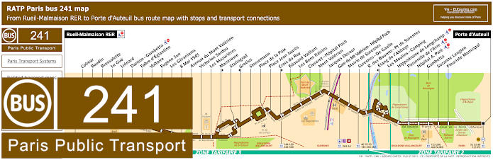
RATP Paris bus line 241 with stops, connections and street plan
Now this is the bus line 241 that travels from Porte d'Auteuil to Rueil-Malmaison RER and this is one of the closest bus routes for getting to the ParisLongchamp horse racing course, as it has a bus stop called the Hippodrome de Longchamp, yet the next nearest is Les Moulins - Camping. Yet we would like to point out that as mentioned earlier, a free shuttle bus is also provided on certain days from the Porte d'Auteuil bus station.
Paris bus line 241 stops:
Rueil-Malmaison RER, Colmar, Baudin, Brossolette, Le Gue, Lienard, Danton - Gambetta, Fabre d'Eglantine, Voltaire, Eugene Sue, Les Geraniums, 8 Mai 1945, Avenue du Mont Valerien, Victorien Sardou, Les Mazurieres, Maistrasse**, Stalingrad, Grotius*, Stresemann, Place de la Paix, Place Jean Jaures, Croix du Roy**, Edouard Vaillant, Les Bons Raisins, Cluseret - Hopital Foch, Mont Valerien, Jacques Decour, Gare du Mt Valerien - Hopital Foch, Mairie de Suresnes, Suresnes - De Gaulle, R. des Bourets - Pt de Suresnes, Etang de l'Abbaye*, Les Moulins - Camping, Hippodrome de Longchamp, Passerelle de l'Avre, Hopital A. Pare, Gambetta, Suzanne Lenglen, Fleuriste Municipal, Porte d'Auteuil.
* Stop served in direction of Rueil-Malmaison RER. ** Stop served in direction of Porte d'Auteuil.
Paris bus line 241 main transport connections:
Metro Line: 10. Train Lines: A, L, U. Bus Lines: 27, 32, 40, 52, 70, 88, 93, 98 (PC), 123, 144, 158, 160, 244, 260, 263, 360, 367, 460, 467, 4E, AS (544), SUBB (571).
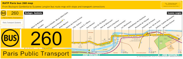
RATP Paris bus line 260 with stops, connections and street plan
Although the bus line 260 run by RATP travels between Gambetta and Suzanne Lenglen with several bus stops in between and to reach the Hippodrome de Longchamp you would need to head in a north westerly direction through the Bois de Boulogne, which is approximately a 1600 to 1800 metre walk.
Paris bus line 260 stops:
Boulogne - Gambetta, Eglise de Boulogne, Escudier, Rhin et Danube - Musee Albert Kahn, Rhin et Danube, Andre Morizet, Square des Freres Farman, Silly - Gallieni, Lycee E. J. Marey, Yves Kermen, Cours de l'Ile Seguin, Parc de Billancourt, Pierre Lefaucheux, Ile Saint-Germain, Les Moulineaux, Mediatheque des Chartreux, Passerelle de l'Europe, Esplanade du Foncet, Issy - Val de Seine, Gallieni - Camille Desmoulins, Rue Henri Farman, Suzanne Lenglen.
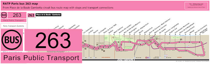
RATP Paris bus line 263 Place de la Boule - Gambetta circuit with stops, connections and street plan
Whereas this shows the bus line 263, which is run by the transport company RATP within the Paris region, and as you will see from the maps and timetables, this is in ticket tariff zone 3 running in a complete circuit from Place de la Boule - Gambetta, and the stop you would need for getting to the Hippodrome de Longchamp is called the Suresnes - Longchamp bus stop, but please take note that it only travels in one direction.
Paris bus line 263 stops:
Place de la Boule - Gambetta, Ombraies**, Ecole Jules Ferry*, Docteur Charcot, Les Gibets, Danton - Gambetta, Fabre d'Eglantine, Voltaire, Le Brix, Les Godardes, La Paix, Racine, La Chapelle, Place du 8 mai 1945, Buffon, Mont Valerien*, Avenue des Landes, Rue du Pas Saint Maurice*, Washington**, Cluseret - Hopital Foch*, Worth**, Hopital Foch**, Gare de Suresnes - Mont Valerien*, Mairie de Suresnes**, De Gaulle, Suresnes - Longchamp**, Eugene Sue*, Jean-Jacques Rousseau**, Place de la Republique*, Fernand Forest**, Monge*, Rue des Couvaloux**, Republique - Val d'Or*.
* Served in the direction of Place de la Boule - Gambetta. ** Heading away from Place de la Boule - Gambetta.
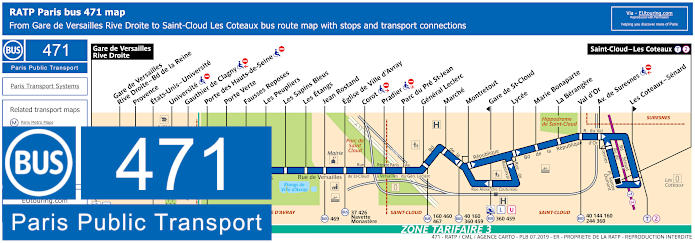
RATP Paris bus line 471 with stops, connections and street plan
The bus line 471 is goes from Saint Cloud - Les Coteaux also with stops at Les Coteaux - Senard or Avenue de Suresnes depending upon your direction of travel and these will get you within approximately 2500 metres of Paris Hippodrome de Longchamp, bus this bus route is also one of the ways you could choose for how to get to Chateau de Versailles, as the line has the second terminus point of Gare de Versailles Rive Droite.
Paris bus line 471 stops:
Gare de Versailles Rive Droite, Gare de Versailles River Droite - Bd de la Reine, Provence, Etata-Unis - Universite, Universite**, Gauthier de Clagny**, Porte des Hauts-de-Seine**, Porte Verte, Fausses Reposes, Les Peupliers, Les Sapins Bleus, Les Etangs, Jean Rostand, Eglise de Ville d'Avray, Corot**, Pradier**, Parc du Pre St-Jean, General Leclerc, Marche, Montretout, Gare de St-Cloud*, Lycee, Marie Bonaparte, La Berangere, Val d'Or, Avenue de Suresnes**, Les Coteaux - Senard*, Saint-Cloud - Les Coteaux.
* Stop is only served in a certain direction. ** Stop not accessible to those with reduced mobility.
Paris bus line 471 main transport connections:
Train Lines: L, U. Tram Line: T2. Bus Lines: 17, 37, 40, 111, 144, 160, 244, 360, 426, 459, 460, 467, 469, A, D, E, G, H, HEX, Navette Monastere (572), TEX, TRI, U.
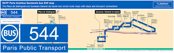
RATP Paris Autobus Suresnes bus line 544 with stops, connections and street plan
Whereas here we have the Bus Line 544 also referred to AS Suresnes, and when you look at the maps and timetables you will see there are two different lines, but you need the dark blue bus line also called the Circuit Liberte, which has a stop and its main terminus point of Suresnes - General de Gaulle, then you would need to go over the River Seine to access the Bois de Boulogne and the Hippodrome de Longchamp flat horseracing course.
The Dark blue route - Circuit Liberte, starts from Suresnes - General de Gaulle, and as the name suggest runs in a complete circuit with additional stops like Gare du Mont Valerien Hopital Foch, Lycee Paul Langevin, Les Chenes, etc.
Paris bus line 544 Circuit Liberte stops (Dark Blue):
General de Gaulle, Mairie de Suresnes, Gare du Mont Valerien - Hopital Foch, Victor Hugo, Lycee Paul Langevin, Les Parechaux, Les Chenes, Danton - Cimetiere Voltaire, Salengro - Cimetiere Voltaire, Capitaine Ferber, Lycee Paul Langevin, Burgod Liberte, Jacques Decour, Mairie Desbassayns.
Paris bus line 544 main transport connections Circuit Liberte (Dark Blue):
Train lines: L, U. Tram line: T2 (walk 8min). Bus lines: 157, 241, 563.
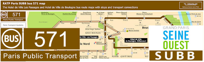
RATP Paris SUBB bus line 571 with stops, connections and street plan
Here you can see the bus line SUBB, also known as bus 571, which operates in the Boulogne-Billancourt area on the outskirts of Paris, which reaches the southern end of the Bois de Boulogne, and as you will see from the maps and timetables, you would need the light brown coloured circuit called Boucle Nord, or Loop North, that has a bus stop called Alsace-Lorraine that will get you to ParisLongchamp approximately 1100 metres away.
Paris bus line 571 stops Boucle Nord:
Hotel de Ville de Boulogne, Marcel Sembat, Victor Hugo - Gallieni, Av. Victor Hugo - Reine, Rond-point Andre Malraux, Place Denfert-Rochereau, Gambetta - Porte de Boulogne, Alsace Lorraine, Hopital Ambroise Pare, Parchamp, Eglis de Boulogne, Parc Edmond de Rothschild, Dispensaire Saint-Denis, Saint-Denis - Anna Jacquin, Saint-Denis - Jean-Baptiste Clement, Rue de Silly - Rue de Paris, Silly - Morizet, Square des Freres Farman, Gallieni - Billancourt, Hotel de Ville - Les Passages.
Paris bus line 571 stops Boucle Sud:
Hotel de Ville - Les Passages, Gallieni - Belle-Feuille, Gallieni - Thiers, Thiers - Edouard Vaillant, Thiers - Maison du combattant, Rue du Point du Jour, Rue de Seine, Pont de Billancourt, Traversiere, Place Jules Guesde, Place Bir-Hakeim, Casteja, Yves Kermen, Lycee E. J. Marey, Pyramide, Hotel de Ville de Boulogne.
Paris bus line 571 main transport connections:
Metro Line: 9. Bus Lines: 42, 52, 72, 123, 126, 175, 260, 289, 389.
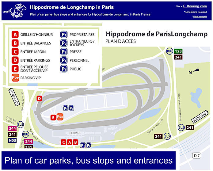
Plan of car parks, bus stops and entrances for Hippodrome de Longchamp in Paris France
Here you can see a general access plan of Hippodrome ParisLongchamp showing the main entrances and car parking along with the main bus lines that will get you closest to this famous horseracing track, which is home to the prestigious Prix de l'Arc de Triomphe flat racing event along with other horse racing events held during the year plus JeuXdi evening racing experiences with music etc, and the Dimanche au Galop Sunday family race days with entertainment.
Paris Hippodrome de Longchamp access plans available: