How to get to Gare du Nord in Paris using public transport
Below you will find different transport options of how to get to Gare du Nord including route maps and timetables for this mainline train station in Paris, which is still one of the main public transport hubs for trains, RER, Metro, buses and Noctilien night buses, where they not just connect the city, but also the Paris region, other parts of France and even different countries including the UK with Eurostar.
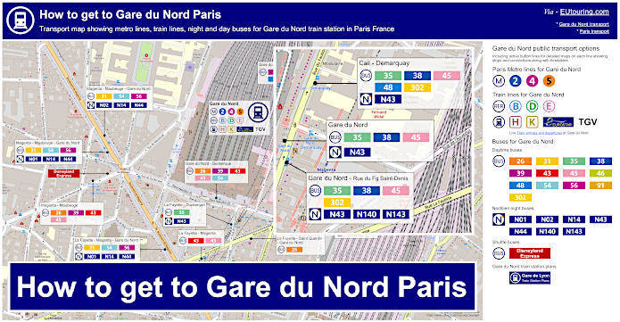
Gare du Nord transport map with Metro lines, trains, bus lines with stops, connections and street plan
This first geographical map shows a street plan of the Gare du Nord train station, showing the transport options for Metro, RER, trains, buses and night buses along with the bus stop locations around this major main line train station, often referred to as Paris Nord.
How to get to Gare du Nord public transport maps available:
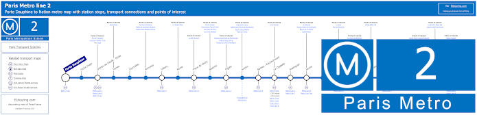
Paris Metro Line 2 map with stations, connections and points of interest
Even though the Paris Metro Line 2 does not go directly to Gare du Nord, this can be accessed from the train station, as you will be able to see from the Paris Nord train station plan further down, and as you will see from the Metro line 2 maps, this travels from Porte Dauphine to Nation, with the La Chapelle Metro stop being the one required for Gare de Nord transport connections.
Metro Line 2 stops:
Porte Dauphine, Victor Hugo, Charles de Gaulle - Etoile, Ternes, Courcelles, Monceau, Villiers, Rome, Place de Clichy, Blanche, Pigalle, Anvers, Barbes - Rochechouart, La Chapelle, Stalingrad, Jaures, Colonel Fabien, Belleville, Couronnes, Menilmontant, Pere Lachaise, Philippe Auguste, Alexandre Dumas, Avron, Nation.
Metro line 2 main transport connections:
Metro Lines: 1, 3, 4, 5, 6, 7, 7bis, 9, 11, 12, 13. Train Lines: A, B, C, D, E, H, K, Funiculaire du Montmartre.
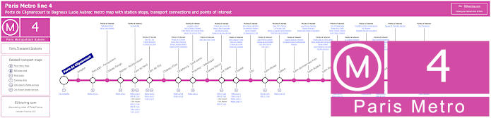
Paris Metro Line 4 map with stations, connections and points of interest
Yet this map above shows the Paris Metro Line 4, which travels from Porte de Clignancourt through to Bagneux Lucie Aubrac and has stops at train stations and transport hubs Gare du Nord, Gare de l'Est, Les Halles, Chatelet, Montparnasse - Bienvenue and Denfert-Rochereau, so you can access many places in Paris and beyond.
Metro line 4 stops:
Porte de Clignancourt, Simplon, Marcadet - Poissonniers, Chateau Rouge, Barbes - Rochechouart, Gare du Nord, Gare de l'Est, Chateau d'Eau, Strasbourg - Saint-Denis, Reaumur - Sebastopol, Etienne Marcel, Les Halles, Chatelet, Cite, Saint-Michel, Odeon, Saint-Germain-des-Pres, Saint-Sulpice, Saint-Placide, Montparnasse - Bienvenue, Vavin, Raspail, Denfert-Rochereau, Mouton-Duvernet, Alesia, Porte d'Orleans, Mairie de Montrouge, Barbara, Bagneux Lucie Aubrac.
Metro line 4 main transport connections:
Metro Lines: 1, 2, 3, 5, 6, 7, 8, 9, 10, 11, 12, 13, 14. Train Lines: A, B, C, D, E, H, K, N, P. Tram Lines: T3a, T3b. Bus Line: OrlyBus.
Paris Metro Line 5 map with stations, connections and points of interest
Whereas here you have the Metro Line 5 that travels from Bobigny - Pablo Picasso to the Place d'Italie and stops at different train stations on route such as Gare du Nord with connections to Eurostar, Gare de l'Est and Gare d'Austerlitz that have transport connections to the outskirts of Paris and beyond, not forgetting this line will also get you close to many tourist attractions like Bastille.
Metro Line 5 stops:
Bobigny - Pablo Picasso, Bobigny - Pantin - Raymond Queneau, Eglise de Pantin, Hoche, Porte de Pantin, Ourcq, Laumiere, Jaures, Stalingrad, Gare du Nord, Gare de l'Est, Jacques Bonsergent, Republique, Oberkampf, Richard-Lenoir, Breguet - Sabin, Bastille, Quai de la Rapee, Gare d'Austerlitz, Saint-Marcel, Campo-Formio, Place d'Italie.
Metro line 5 main transport connections:
Metro Lines: 1, 2, 3, 4, 6, 7, 7b, 8, 9, 10, 11. Train Lines: B, C, D, E, H, K, P. Tram Lines: T1, T3b.
Blue RER B train line map showing station stops, line branches, transport connections and zones
Now here we have the maps for the RER B line which has different branches that stops at many different tourist attractions like La Plaine - Stade de France and Parc de Sceaux, Gare du Nord for a Paris to Charles de Gaulle Airport transport connection.
Additionally, this train line provides transport connections such as Denfert-Rochereau and Antony, which is how to get to Orly Airport using the RER B train, along with many other train stops such as Le Bourget where you can get to the aviation museum and airport that hosts the Paris air show.
Paris RER B train line stops:
Mitry–Claye*, Villeparisis - Mitry-le-Neuf, Vert-Galant, Sevran–Livry, Aulnay-sous-Bois, Le Blanc-Mesnil, Drancy, Le Bourget, La Courneuve - Aubervilliers, La Plaine - Stade de France, Gare du Nord, Chatelet - Les Halles, Saint-Michel - Notre-Dame, Luxembourg, Port-Royal, Denfert-Rochereau, Cite Universitaire, Gentilly, Laplace, Arcueil - Cachan, Bagneux, Bourg-la-Reine, Sceaux, Fontenay-aux-Roses, Robinson*, Aeroport Charles de Gaulle 2 - TGV*, Aeroport Charles de Gaulle 1, Parc des Expositions, Villepinte, Sevran - Beaudottes, Parc de Sceaux, La Croix de Berny, Antony (Orly), Fontaine-Michalon, Les Baconnets, Massy - Verrieres, Massy - Palaiseau, Palaiseau, Palaiseau - Villebon, Lozere (Ecole Polytechnique), Le Guichet, Orsay–Ville, Bures-sur-Yvette, La Hacquiniere, Gif-sur-Yvette, Courcelle-sur-Yvette, Saint-Remy-les-Chevreuse*.
* Terminus Points.
Paris RER B train line main transport connections:
Metro Lines: 1, 2, 4, 5, 6, 7, 10, 11, 14. Train Lines: A, C, D, E, H, K, TGV, CDG Val, Orly Val. Tram Lines: T3a, T4, T11. Bus Lines: TVM (14), OrlyBus, RoissyBus.
Green RER D train line map showing station stops, line branches, transport connections and zones
The green RER D line also has a stop at Gare du Nord train station along with Chatelet-Les-Halles and Gare de Lyon in Paris, yet this train travels out to beyond tariff Zone 5 within Ile de France providing numerous different train station stops, even out to Chantilly-Gouvieux to reach the chateau, plus there are various branches where you can access other transport like trams, and even TGV high speed trains.
Paris RER D train line stops:
Creil*, Chantilly - Gouvieux, Orry-la-Ville - Coye-la-Foret, La Borne Blanche, Survilliers - Fosses, Louvres, Les Noues, Goussainville, Villiers-le-Bel - Gonesse - Arnouville, Garges - Sarcelles, Pierrefitte - Stains, Saint-Denis, Stade de France - Saint-Denis, Paris Gare du Nord, Chatelet - Les-Halles, Paris Gare de Lyon, Maisons-Alfort - Alfortville, Le Vert de Maisons, Creteil - Pompadour, Villeneuve - Triage, Villeneuve - Saint-Georges, Montgeron-Crosne, Yerres, Brunoy, Boussy - Saint-Antoine, Combs-la-Ville - Quincy, Lieusaint-Moissy, Savigny-le-Temple - Nandy, Cesson, Le Mee-sur-Seine, Melun*, Vigneux-sur-Seine, Juvisy**, Viry Cahatillon**, Ris - Orangis, Grand-Bourg, Evry - Val de Seine, Grigny Centre, Orangis - Bois de l'Epine, Evry - Courcouronnes (Centre), Le Bras de Fer (Evry Genepole), Corbeil - Essonnes**, Essonnes - Robinson, Villabe, Le Plessis - Chenet, Le Coudray - Montceaux, Saint-Fargeau, Ponthierry - Pringy, Poissise-le-Roi, Vosves, Melun**, Moulin Galant, Mennecy, Ballancourt, La Ferte-Alais, Boutigny, Maisse, Buno Gironville, Boigneville, Malesherbes*.
* Terminus points. ** RER D Transfer points.
Paris RER D train line main transport connections:
Metro Lines: 1, 2, 4, 5, 7, 11, 14. Train Lines: A, B, C, E, H, K, P, R, TGV, TER. Tram Lines: T1, T5, T8, T11. Bus Lines: 20, 393, Senlis, TVM (14), Tzen 1.
Pink RER E train line map showing station stops, line branches, transport connections and zones
As you will see from the RER E maps, this starts from Haussmann - St-Lazare, which links with the transport for Gare Saint-Lazare, with two branches that then go to Chelles - Gournay and Tournan, yet as you can also see, this train line actually stops at Gare Magenta, which is located in between Paris Nord and Gare de l'Est, yet can be accessed directly from the Gare du Nord Train Station, which is why the train stop is sometimes called Gare du Nord - Magenta.
Paris RER E train line stops:
Haussmann St-Lazare*, Gare du Nord - Magenta, Rosa Parks, Pantin, Noisy le Sec, Bondy, Le Raincy - Villemomble - Montfermeil, Gagny, Le Chenay - Gagny, Chelles - Gournay*, Rosny - Bois Perrier, Rosny-sous-Bois, Val de Fontenay, Nogent - Le Perreux, Les Boullereaux - Champigny, Villiers sur Marne - Le Plessis Trevise, Les Yvris - Noisy le Grand, Emerainville - Pontault Combault, Roissy en Brie, Ozoir la Ferriere, Gretz - Armainvilliers, Tournan*.
* Terminus Points.
Paris RER E train line main transport connections:
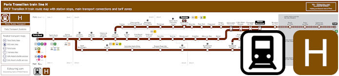
Transilien train line H map showing station stops, line branches, transport connections and zones
Yet this next map shows the Transilien line H regional train that starts from Paris Gare du Nord, which has only two stops before you can then branch off to access numerous train stations including the key points of Pontoise, Persan Beaumont, Luzarches and Creil, which is also an option of how to get to Stade de France via the Saint-Denis train station.
Paris train line H stops:
Paris Gare du Nord*, Saint-Denis, Epinay - Villetaneuse, La Barre Ormesson, Enghien les Bains, Champ de Courses d'Enghien, Ermont - Eaubonne, Cernay, Franconville - Le Plessis Bouchard, Montigny Beauchamp, Pierrelaye, St-Ouen l'Aumone - Liesse, St-Ouen l'Aumone, Pontoise*, Ermont - Halte, Gros Noyer St-Prix, St-Leu la Foret, Vaucelles, Taverny, Bessancourt, Frepillon, Mery sur Oise, Meriel, Epluches, Pont Petit, Chaponval, Auvers sur Oise, Valmondois, L'Isle Adam Parmain, Champagne sur Oise, Persan Beaumont*, Bruyeres sur Oise, Boran sur Oise, Precy sur Oise, St-Leu d'Esserent, Creil*, Deuil Montmagny, Groslay, Sarcelles St-Brice, Ecouen Ezanville, Domont, Bouffemont - Moisselles, Montsoult - Maffliers, Presles Courcelles, Nointel Mours, Villaines, Belloy St-Martin, Viarmes, Seugy, Luzarches*.
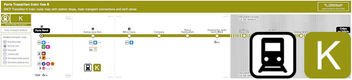
Transilien train line K map showing station stops, transport connections and zones
Although here you can see the Transilien Line K, which is the mustard colour on the map, that also goes from Paris Gare du Nord, but with only eight stops in between including Aulnay sous Bois and Mitry-Claye with their transport connections, before reaching the terminus of Crepy en Valois within the Paris region of Ile de France.
Paris train line K stops:
Paris Gare du Nord*, Aulnay sous Bois, Mitry-Claye, Compans, Thieux Natouillet, Dammartin Juilly St-Mard, Le Plessis - Belleville, Nanteuil le Haudouin, Ormoy Villers, Crepy en Valois*.
* Terminus Points.
Paris train line K main transport connections:
Metro Lines: 2, 4, 5, 7. Train Lines: B, C, D, E, H, J, P, TER, TGV. Tram Line: T4.
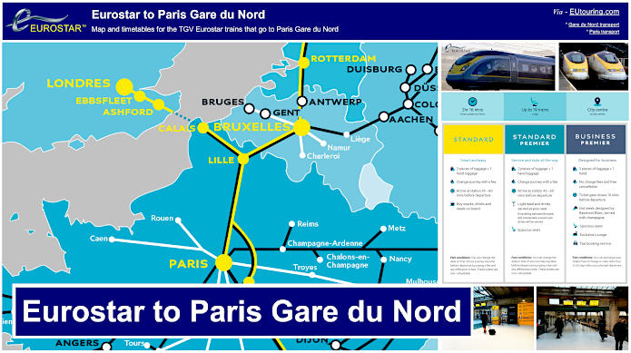
Eurostar train from London to Paris Gare du Nord map showing timetables, stops and ticket costs
Whereas this is the map for Eurostar, also showing timetables and information on tickets and pricing for getting from London to Paris, along with additional stops and connection points that this high speed train has, in addition to the link below that will take you to the live train arrivals and departures at Paris Gare du Nord train station for the Eurostar, other TGV high speed trains and the regional trains mentioned above.
London to Paris Eurostar train timetables and maps available:
RATP Paris bus line 26 with stops, connections and street plan
Now as you would have seen from how to get to Gare du Nord with the street plan around this Paris train station and transport hub, there are numerous buses that include the RATP bus line 26, which travels from Gare Saint-Lazare through to Nation - Trone and the stop at this train station is called Gare du Nord - Dunkerque at the Place Napoleon III in one direction, or La Fayette - Saint Quentin - Gare du Nord on the Rue La Fayette in the opposite direction.
Paris bus line 26 stops:
Gare Saint-Lazare, Gare Saint-Lazare - Budapest*, Trinite, St-Georges - Chateaudun, Carrefour de Chateaudun, Chateaudun - Lamartine*, Cadet*, Maubeuge - Rochechouart*, Square Montholon*, Condorcet*, Place Franz Liszt*, Magenta - Maubeuge*, La Fayette - St-Quentin - Gare du Nord*, Gare du Nord - Dunkerque*, La Fayette - Dunkerque, Chateau Landon, Louis Blanc*, Jaures - Stalingrad*, Marche Secretan, Mathurin Moreau - S. Bolivar, Atlas, Botzaris - Buttes Chaumont, Pyrenees - Belleville, Jourdain, L'Ermitage, Pyrenees - Menilmontant, Villiers de l'Isle Adam, Gambetta - Pyrenees, Ramus, Pyrenees - Bagnolet, Orteaux, Maraichers, La Plaine, Cours de Vincennes, Marsoulan, Nation - Trone.
* Stop only served in a particular direction.
Paris bus line 26 main transport connections:
Metro Lines: 1, 2, 3, 3bis, 4, 5, 6, 7, 7bis, 9, 11, 12, 13, 14. Train Lines: A, B, D, E, H, J, K, L, P. Tram Lines: T3a, T3b.
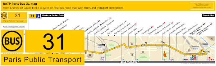
RATP Paris bus line 31 with stops, connections and street plan
There is often more than one bus stop at a train station for the same number bus, just like the Paris Bus route for the RATP line 31, which stops at the Magenta - Maubeuge - Gare du Nord stop for the direction of Gare de l'Est, or the La Fayette - Magenta - Gare du Nord for the direction of Charles de Gaulle - Etoile, which is how to get to the Arc de Triomphe and Tomb of the Unknown Soldier.
Paris bus line 31 stops:
Charles de Gaulle - Etoile, Charles de Gaulle - Etoile - Wagram**, Hoche - Saint-Honore*, Ternes, Wagram - Courcelles, Wagram - Prony, Jouffroy d'Abbans - Villiers, Jouffroy d'Abbans - Malesherbes, Jouffroy d'Abbans - Tocqueville, Pont Cardinet, Parc Martin Luther King**, Parc Martin Luther King*, Brochant - Cardinet, Moines - Davy, Guy Moquet, Vauvenargues, Damremont - Ordener, Duhesme - Le Ruisseau, Mairie du 18e - Jules Joffrin, Marcadet - Poissonniers, Chateau Rouge, Barbes - Rochechouart, Magenta - Maubeuge - Gare du Nord, La Fayette - Magenta - Gare du Nord, Gare de l'Est.
* Served in direction of Charles de Gaulle - Etoile. ** Served in direction of Gare de l'Est.
Paris bus line 31 main transport connections:
Metro Lines: 1, 2, 3, 4, 5, 6, 7, 12, 13, 14. Train Lines: A, B, D, E, H, K, L, P.
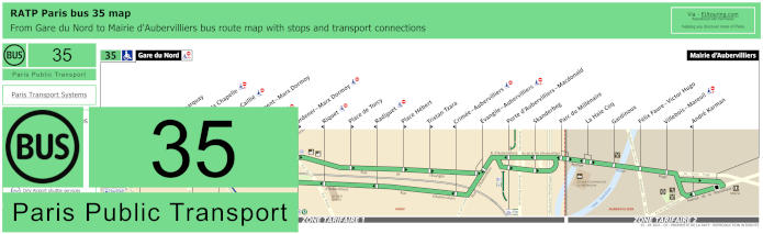
RATP Paris bus line 35 with stops, connections and street plan
And these maps shows the Paris Bus route for the RATP but line 35 that travels between Gare du Nord and Mairie d'Aubervilliers with different stops on route including Place de la Chapelle, and as you can see from the street maps and timetables, the Gare du Nord terminus bus stop is located on the Rue du Faubourg Saint-Denis on either side of the street depending upon your direction of travel.
Paris bus line 35 stops:
Gare du Nord**, Cail - Demarquay, Place de la Chapelle**, Chaplle - Caillie*, Departement - Marx Dormoy, Maroc* **, Ordener - Marx Dormoy**, Riquet* **, Place de Torcy, Place Hebert, Tristan Tzara, Crimee Aubervilliers* **, Evangile - Aubervilliers, Porte d'Aubervilliers - MacDonald, Skanderbeg, Parc du Millenaire, La Haie Coq, Gardinoux, Felix Faure - Victor Hugo, Villebois - Mareuil**, Andre Karman*, Mairie d'Aubervilliers.
* Stop on served in the direction of Gare du Nord. ** Stop not accessible to those with reduced mobility.
Paris bus line 35 main transport connections:
Metro lines: 2, 4, 5, 12. Train lines: B, D, E, H, K. Tram line: T3b.
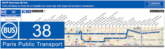
RATP Paris bus line 38 with stops, connections and street plan
Whereas the RATP Paris Bus line 38 also stops at the same locations at Gare du Nord as above or at the bus stop called Valenciennes, yet this bus route goes from Porte d'Orleans through to Porte de la Chapelle with numerous different bus stops and transport connections in between, but we would like to point out, that as you can see from the street maps and timetables, some stops on route are only served in a particular direction.
Paris bus line 38 stops:
Porte d'Orleans, Alesia - General Leclerc, Alesia - Maine*, Mouton - Duvernet, Denfert-Rochereau - Daguerre**, Denfert-Rochereau*, Denfert-Rochereau - Arago, Hopital Saint-Vincent de Paul, Observatoire - Port-Royal, Val de Grace, Auguste Comte, Luxembourg, Les Ecoles, Saint-Michel - Saint-Germain, Cite - Palais de Justice, Chatelet, Coutellerie*, Les Halles - Centre Georges Pompidou**, Centre Georges Pompidou*, Turbigo - Etienne Marcel**, Grenier St-Lazare - Quartier de l’Horloge*, Reaumur - Arts et Metiers*, Reaumur - Sebastopol**, Strasbourg - Saint-Denis**, Porte Saint-Martin*, Chateau d’Eau**, Mairie du 10e*, Magenta - Saint-Martin*, Gare de l’Est, Valenciennes, Gare du Nord, Cail-Demarquay, Place de la Chapelle, Departement-Marx Dormoy, Ordener - Marx Dormoy, Les Roses, Boucry, Porte de la Chapelle.
*Stops served in direction of Porte d'Orleans. ** Stops served in direction of Porte de la Chapelle.
Paris bus line 38 main transport connections:
Merto Lines: 1, 2, 3, 4, 5, 6, 7, 8, 9, 11, 12, 14. Train Lines: A, B, C, D, E, H, K, P. Tram Lines: T3a, T3b.
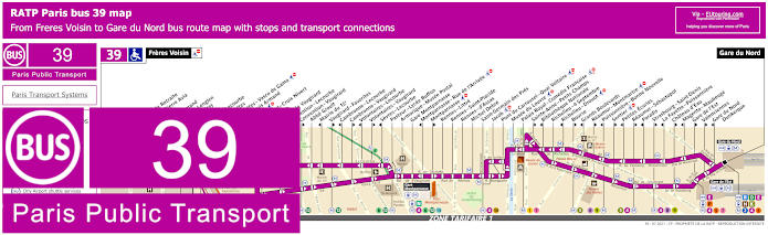
RATP Paris bus line 39 with stops, connections and street plan
Yet this map and its timetables show the Paris Bus route for the RATP line 39 travelling between Freres Voisin and Gare du Nord train station with the stop being at the Place Napoleon III. With this bus route having over 50 different bus stops and many transport connections at Gare de l'Est, Gare Montparnasse plus others, you will, however, see that some stops are only served in a particular direction.
Paris bus line 39 stops:
Freres Voisin, Maison de Retraite**, Colonel Pierre Avia*, Severine**, Louis Armand*, Suzanne Lenglen*, Porte d’Issy**, Balard*, Balard - Lecourbe*, Desnouettes**, Desnouettes - Vasco de Gama**, Lycee Louis Armand*, Hameau**, Duranton**, Hopital de Vaugirard**, Convention - Lecourbe*, Convention - Vaugirard**, Abbe Groult, Mairie du 15e*, Vaugirard - Favorites**, Cambronne - Lecourbe*, Cambronne - Vaugirard**, Volontaires - Lecourbe*, Volontaires - Vaugirard**, Sevres - Lecourbe*, Pasteur - Lycee Buffon, Armorique - Musee Postal, Gare Montparnasse, Montparnasse - Rue de l’Arrivee*, Montparnasse**, Rennes - Littre, Rennes - Saint-Placide, Rennes - d’Assas, Michel Debre, Saint-Germain des Pres, Jacob, Pont du Carrousel - Quai Voltaire, Musee du Louvre, Palais Royal - Comedie Francaise, Sainte-Anne - Petits Champs**, Bibliotheque Nationale*, Richelieu - 4 Septembre, Richelieu - Drouot*, Bourse**, Grands Boulevards*, Reaumur - Montmartre**, Poissonniere - Bonne Nouvelle*, Sentier**, Petites Ecuries*, Reaumur - Sebastopol**, Paradis*, Strasbourg - Saint-Denis**, La Fayette - Poissonniere*, Chateau d'Eau**, Magenta - Maubeuge*, Gare de l'Est**, Valenciennes**, Gare du Nord - Dunkerque*, Gare du Nord.
* Served in the direction of Freres Voisin ** Served in the direction of Gare du Nord
Paris bus line 39 main transport connections:
Metro lines: 1, 2, 3, 4, 5, 6, 7, 8, 9, 10, 12, 13. Train lines: B, D, E, H, K, N, P. Tram lines: T2, T3a.
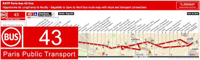
RATP Paris bus line 43 with stops, connections and street plan
The Paris bus line 43 run by the company RATP goes from Gare du Nord to Neuilly - Bagatelle or for additional transport to Hippodrome de Longchamp on a Saturday and Sunday, and as you can see from the street plan map and timetables, there are also several bus stops all around this mainline train station including Magenta - Maubeuge and Place Franz Liszt, Lafayette - Magenta and Gare du Nord - Dunkerque but for a particular direction of travel.
Paris bus line 43 stops:
Hippodrome de Longchamp*, Longchamp - GoodPlanet**, Les Moulins - Camping* ***, Route des Moulins* ***, Parc de Bagatelle*, Neuilly - Bagatelle, Place de Bagatelle, Rue du Centre, Rue du Bois de Boulogne, Maurice Barres, Pont de Neuilly, General Gouraud, Rue de l’Eglise**, Sainte-Foy, Eglise Saint-Pierre, Chartres, Montrosier - Parmentier, General Koenig - Palais des Congres, Pereire - Porte Maillot, Eglise Saint-Ferdinand, Ternes - Mac-Mahon, Ternes, Hoch - Saint-Honore, Friedland - Haussmann, Haussmann - Courcelles, Haussmann - Miromesnil, Saint-Augustin - La Boetie***, Saint-Augustin**, Pasquier - Anjou***, Gare Saint-Lazare**, Gare Saint-Lazare - Havre***, Gare Saint-Lazare - Budapest***, Trinite, Saint-Georges - Chateaudun, Carrefour de Chateaudun, Chateaudun - Lamartine***, Cadet**, Maubeuge - Rochechouart***, Square Montholon**, Condorcet***, Magenta - Maubeuge***, Place Franz Liszt**, Lafayette - Magenta**, Gare du Nord - Dunkerque***, Gare du Nord.
* Stop only served on a Saturday and Sunday. ** Served in the direction of Gare du Nord. *** Served in the direction of Neuilly - Bagatelle / Hippodrome de Longchamp.
Paris bus line 43 main transport connections:
Metro Lines: 1, 2, 3, 4, 5, 7, 9, 12, 13, 14. Train Lines: B, C, D, E, J, L.
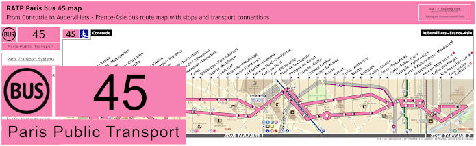
RATP Paris bus line 45 with stops, connections and street plan
Although the Paris bus route for RATP line 45 travels between Concorde and Aubervilliers-France-Asie with many bus stops in between like Madeleine, Opera, etc and there are several around the vicinity of Gare du Nord like above, yet please do take note of the street map for bus 45 as the stops vary in location depending upon direction of travel.
Paris bus line 45 stops:
Concorde, Concorde - Royale**, Madeleine - Malesherbes*, Madeleine, Capucines - Caumartin, Opera - Scribe*, Opera**, Chaussee d'Antin, Saint-Georges - Provence**, Le Peletier**, Le Peletier - Haussmann*, Carrefour de Chateaudun*, Chateaudun - Lamartine*, Cadet**, Maubeuge - Rochechouart*, Square Montholon**, Condorcet*, Magenta - Maubeuge*, Place Franz Liszt**, La Fayette - Magenta**, Gare du Nord - Dunkerque*, Gare du Nord, Cail - Demarquay, Place de la Chapelle, Philippe de Girard**, Chapelle - Caillie*, Chateau Landon**, Place du Maroc**, Maroc*, Riquet*, Curial - Archereau**, Mathis**, Radiguet*, Curial - Crimee**, Crimee - Rosa Parks**, Crimee - Aubervilliers*, Evangile - Aubervilliers, Porte d'Aubervilliers - Macdonald, Skanderbeg, Parc du Millenaire, Jardin des Berges, Rue de La Hale Coq*, Quai Lucien - Lefranc**, Aubervilliers - France-Asie.
* Stop served in the direction of Concorde. ** Stop served in the direction of Aubervilliers - France-Asie.
Paris bus line 45 main transport connections:
Metro Lines: 1, 2, 3, 4, 5, 7, 8, 9, 12, 14. Train Lines: A, B, D, E, H, K. Tram Line: T3b.
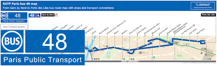
RATP Paris bus line 48 with stops, connections and street plan
And here we have the map with its timetables showing the Paris Bus route 48 for the RATP line that travels from Gare du Nord to Porte des Lilas with different bus stops in between, which have transport connections like at Place de la Chapelle, Jaures, Place des Fetes, Mouzaia, and others.
Paris bus line 48 stops:
Gare du Nord, Cail - Demarquay, Place de la Chapelle, Philippe de Girard, Chapelle - Caillie, Chateau Landon, Stalingrad, Jaures, Rue de Meaux, Armand Carrel - Mairie du 19e, Manin, Botzaris, Place des Fetes, Louise Thuliez, Pre-Saint-Gervais - Alles, Mouzaia, Rue des Bois, Hopital Robert Debre, Hopital Robert Debre - Pre-Saint-Gervais, Les Marronniers, Jean Jaures, Rene Fonck, Porte des Lilas.
Paris bus line 48 main transport connections:
Metro Lines: 2, 3bis, 4, 5, 7bis, 11. Train Lines: B, D, E, H, K. Tram Line: T3b.
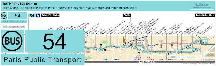
RATP Paris bus line 54 with stops, connections and street plan
However, this map and its timetables show the Paris Bus 54 route for the RATP bus line 54 that travels between Gabriel Peri - Metro, Pigalle and Porte d'Aubervilliers, which has over 40 different bus stops going to places like Porte de Clichy, the Gare du Nord - Dunkerque bus stop, Gare de l'Est, Quai de Seine - Stalingrad, also showing how to get to Sacre Coeur Basilica with this bus route and many more tourist attractions.
Paris bus line 54 stops:
Gabriel Peri - Metro, Place Voltaire, Leon Blum, Danielle Casanova**, Landy - Martre*, Mairie de Clichy, Barbusse - Martre*, Jaures - Barbusse**, Victor Hugo - 8 Mai 1945*, Victor Hugo - Jean Jaures**, Porte de Clichy, Boulay, Brochant - Cardinet, Rue des Moines*, Legendre, La Fourche, Ganneron, Place de Clichy**, Place de Clichy - Caulaincourt*, Blanche, Pigalle, Rochechouart - Martyrs, Anvers - Sacre Coeur, Rochechouart - Clignancourt, Barbes - Rochechouart, Magenta - Maubeuge - Gare du Nord, La Fayette - Magenta - Gare du Nord**, Gare du Nord - Dunkerque*, Valenciennes*, Gare de l'Est, Verdun, Chateau Landon, Louis Blanc, Chaudron - Saint-Martin*, Quai de Seine - Stalingrad, Maroc - Flandre, Riquet, Crimee, Crimee - Archereau*, Crimee - Curial, Crimee - Rosa Parks, Flandre**, Cambrai**, Porte d’Aubervilliers - Macdonald, Porte d'Aubervilliers.
* Served in direction of Gabriel Peri - Metro. ** Served in direction of Porte d'Aubervilliers.
Paris bus line 54 main transport connections:
Metro Lines: 2, 4, 5, 7, 7bis, 12, 13, 14. Train Lines: B, C, D, E, H, K, P. Tram Line: T3b.
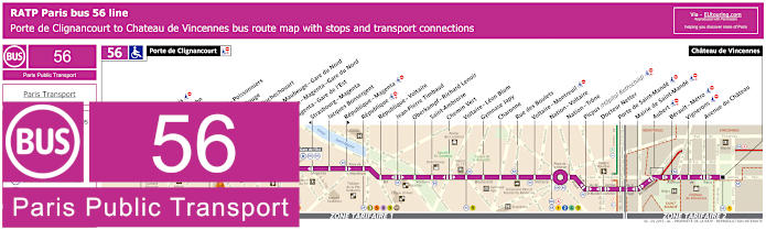
RATP Paris bus line 56 with stops, connections and street plan
So this map and its timetables shows the RATP Paris Bus route for line 56 that travels from Porte de Clignancourt which is a transport option for Chateau de Vincennes, and some of the bus stops have numerous transport connections including La Fayette - Magenta - Gare du Nord for the Paris Nord train station, Republique, Nation - Voltaire, and many others.
Paris bus line 56 stops:
Porte de Clignancourt, Mont-Cenis*, Albert Kahn, Simplon, Marcadet - Poissonniers, Chateau Rouge, Barbes - Rochechouart, Magenta - Maubeuge - Gare du Nord, La Fayette - Magenta - Gare du Nord, Magenta - Gare de l’Est, Strasbourg - Magenta*, Jacques Bonsergent, Republique - Magenta*, Republique, Republique - Voltaire, Jean-Pierre Timbaud, Oberkampf - Richard Lenoir, Saint-Ambroise, Chemin Vert, Voltaire - Leon Blum, Gymnase Japy, Charonne, Rue des Boulets, Voltaire - Montreuil, Nation - Voltaire, Nation - Trone, Picpus (Hopital Rothschild), Docteur Netter, Porte de Saint-Mande, Mairie de Saint-Mande, Aubert, Berault - Metro, Vignerons, Avenue du Chateau, Chateau de Vincennes.
* Bus stop is direction dependant.
Paris bus line 56 main transport connections:
Metro Lines: 1, 2, 3, 4, 5, 6, 8, 9, 11, 12. Train Lines: A, B, D, E, H, K. Tram Line: T3b.
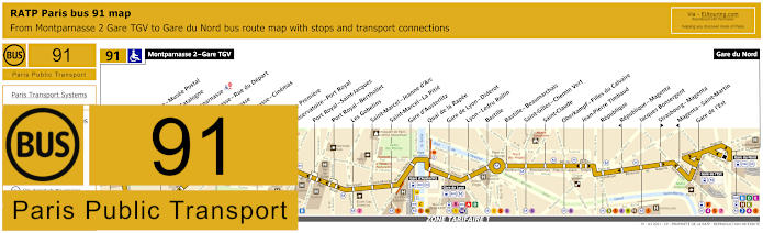
RATP Paris bus 91 map with stops, connections and route plan
The RATP Paris Bus Line 91 goes between major transport hubs of Gare du Nord and Montparnasse 2 - Gare TGV with numerous bus stops on route that go to popular tourist attractions like Bastille, and as you can see from the maps and timetables, there are also many transport connections at Gare d'Austerlitz train station, Gare de Lyon - Diderot and Gare de l'Est, etc, making this bus route an easy way to get around Paris to key locations within the Paris region and beyond.
Paris bus line 91 stops:
Montparnasse 2 - Gare TGV, Armorique - Musee Postal, Place de Catalogne, Gare Montparnasse, Montparnasse - Rue du Depart, Montparnasse, Montparnasse - Cinemas, Vavin, Campagne Premiere, Observatoire - Port Royal, Port Royal - Saint-Jacques, Port Royal - Berthollet, Les Gobelins, Saint-Marcel - Jeanne d'Arc, Saint-Marcel - La Pitie, Gare d'Austerlitz, Quai de la Rapee, Gare de Lyon - Diderot, Lyon - Ledru Rollin, Bastille, Bastille - Beaumarchais, Saint-Gilles - Chemin Vert, Saint-Claude, Oberkampf - Filles du Calvaire, Jean-Pierre Timbaud, Republique, Republique - Magenta, Jacques Bonsergent, Strasbourg - Magenta, Magenta - Saint-Martin, Gare de l'Est, Gare du Nord.
Paris bus line 91 main transport connections:
Metro Lines: 1, 2, 3, 4, 5, 6, 7, 8, 9, 10, 11, 12, 13, 14. Train Lines: A, B, C, D, E, H, K, N, P, R.
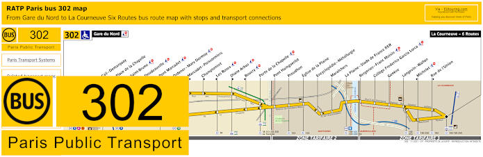
RATP Paris bus line 302 with stops, connections and street plan
But the RATP Paris bus route 302 travels from Gare du Nord to La Courneuve - Six Routes and as you can see from the bus map and street plan we provided earlier, the bus stop at Gare du Nord is on the Rue du Faubourg Saint-Denis, and travelling through 3 ticket zones it also stops at Porte de la Chapelle and La Plaine - Stade de France, meaning this is also one of the easy transport options for Stade de France sports and entertainment events.
Paris bus line 302 stops:
Gare du Nord, Cail - Demarquay, Place de la Chapelle, Saint-Bruno, Doudeauville, Pont Marcadet, Ordener - Marx Dormoy*, Marcadet - Poissonniers**, Championnet**, Les Roses*, Diane Arbus**, Boucry*, Porte de la Chapelle, Pont Hainguerlot, Proudhon, Eglise de la Plaine, Encyclopedie - Metallurgie, Maraichers, La Plaine - Stade de France RER, Bergeries - Franc Moisin, College F. Garcia Lorca, Geneve, Langevin - Wallon, Michelet*, Rue de l'Union**, La Courneuve - Six Routes.
* Stop served in direction of Gare du Nord. ** Stop served in direction of La Courneuve - Six Routes.
Paris bus line 302 main transport connections:
Metro lines: 2, 4, 5, 12. Train lines: B, D, E, H, K. Tram lines: T1, T3b. Bus lines: 26, 35, 38, 39, 43, 45, 48, 54, 60, 91, 139, 143, 150, 153, 173, 239, 250, 252, 253, 350, 353, La Traverse, N01, N02, N43, N143.
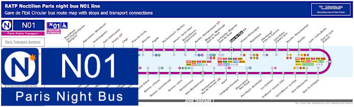
Paris Noctilien night bus N01 map with stops and transport connections
This first Noctilien map and its timetables show the Paris night bus route for the RATP line N01, which is referred to as Circulaire Interieure, or the Interior Circuit that goes in a loop between approximately 12:30am and 5:30am, stopping at numerous tourist attractions and train stations for various transport connections including the Gare de l'Est, Gare du Nord on the Boulevard de Magenta, Gare de Lyon - Diderot, etc.
Paris night bus line N01 stops:
Gare de l'Est, Jacques Bonsergent, Republique, Oberkampf - Filles du Calvaire, Saint-Gilles - Chemin Vert, Bastille - Beaumarchais, Bastille, Lyon - Ledru-Rollin, Gare de Lyon - Diderot, Quai de la Rapee, Gare d'Austerlitz, Saint-Marcel - La Pitie, Saint-Marcel - Jeanne d'Arc, Les Gobelins, Port Royal - Berthollet, Observatoire - Port Royal, Campagne Premiere, Vavin, Montparnasse - Rue de l'Arrivee, Gare Montparnasse, Montparnasse, Rennes - Littre, Rennes - Saint-Placide, Rennes - d'Assas, Michel Debre, St-Germain-des-Pres, Pont du Carrousel - Quai Voltaire, Henry de Montherlant, Assemblee Nationale, Pont Alexandre III, Palais de la Decouverte, Rond-Point des Champs-Elysees - Matignon, Haussmann - Miromesnil, Saint-Augustin, Gare Saint-Lazare, Trinite, Liege, Place de Clichy, Blanche, Pigalle, Rochechouart - Martyrs, Anvers - Sacre-Coeur, Rochechouart - Clignancourt, Barbes - Rochechouart, Magenta - Mauberge - Gare du Nord, La Fayette - Magenta - Gare du Nord, Gare de l'Est.
Paris night bus line N01 main transport connections:
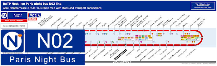
Paris Noctilien night bus N02 map with stops and transport connections
Whereas here you can see the map for the Noctilien Bus route N02, which is known as the Circulaire Exterieure, or Exterior Circuit, that provides a night bus service to many key locations in Paris, where you can also get connections to other night bus lines and additional transport when they start operating again early morning, just like at Gare du Nord, Gare Montparnasse, Gare Saint-Lazare, etc.
Paris night bus line N02 stops:
Gare Montparnasse, Montparnasse, Vavin, Campagne Premiere, Observatoire - Port Royal, Port Royal - Berthollet, Les Gobelins, Saint-Marcel - Jeanne d'Arc, Saint-Marcel - La Pitie, Gare d'Austerlitz, Quai de la Rapee, Gare de Lyon - Diderot, Lyon - Ledru-Rollin, Bastille, Bastille - Beaumarchais, Saint-Gilles - Chemin Vert, Oberkampf - Filles du Calvaire, Republique, Jacques Bonsergent, Gare de l'Est, La Fayette - Magenta - Gare du Nord, Magenta - Maubeuge - Gare du Nord, Barbes - Rochechouart, Rochechouart - Clignancourt, Anvers - Sacre-Coeur, Rochechouart - Martyrs, Pigalle, Blanche, Place de Clichy - Caulaincourt, Place de Clichy, Bucarest, Europe, Gare Saint-Lazare - Rome, Saint-Augustin, La Boetie - Percier, Rond-Point des Champs-Elysees - Franklin D. Roosevelt, Palais de la Decouverte, Pont Alexandre III, Assemblee Nationale, Solferino - Bellechasse, Saint-Guillaume, Saint-Germain-des-Pres, Michel Debre, Rennes - d'Assas, Rennes - Saint-Placide, Rennes - Little, Montparnasse - Rue de l'Arrivee, Gare Montparnasse.
Paris night bus line N02 main transport connections:
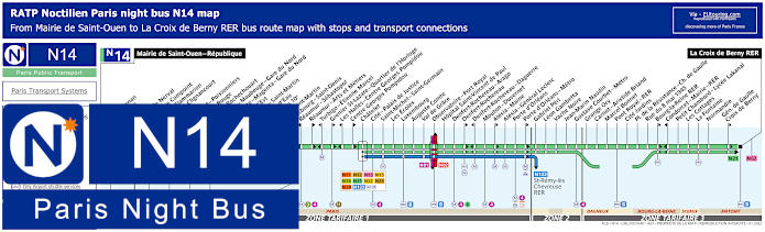
Paris Noctilien night bus N14 map with stops and transport connections
Although, Noctilien bus line N14 travels between the Mairie de Saint-Ouen and La Croix de Berny RER, travelling through Paris to the outskirts with night bus stops at many strategic locations including the many transport connections at Chatelet, and although this Noctilien map does not show the transport connections for Gare de Nord, this is still a very significant train station with numerous options for public transport including Eurostar, etc that we mentioned earlier.
Paris night bus line N14 stops:
Mairie de Saint-Ouen - Republique, Ernest Renan, Garibaldi, Kleber, Gerard de Nerval, Angelique Compoint, Camille Flammarion, Porte de Clignancourt, Simplon, Marcadet - Poissonniers, Chateau Rouge, Barbes - Rochechouart, Magenta - Mauberge - Gare du Nord, La Fayette - Magenta - Gare du Nord, Gare de l'Est, Magenta - Saint Martin*, Chateau d'Eau**, Mairie du 10e*, Porte Saint-Martin*, Strasbourg - Saint-Denis**, Reaumur - Sebastopol**, Reaumur - Arts et Metiers*, Turbigo - Etienne Marcel**, Grenier St-Lazare - Quartier de l'Horloge*, Les Halles - Centre Georges Pompidou**, Centre Georges Pompidou*, Chatelet, Cite - Palais de Justice, Saint-Michel - Saint-Germain, Les Ecoles, Luxembourg, Auguste Comte, Val du Grace, Observatoire - Port Royal, Hopital Saint-Vincent de Paul, Denfert-Rochereau -Arago, Denfert-Rochereau*, Denfert-Rochereau - Daguerre**, Mouton - Duvernet, Alesia - Maine*, Alesia - General Leclerc, Porte d'Orleans, Porte d'Orleans - Metro*, Gabriel Peri, Leon Gambetta, Vache Noire, Jean-Marin Naudin, Gustave Courbet - Metro, Grange Ory, Carnot - Aristide Briand, Marcel Bonnet, Pont Royal - RER, Cite Jardins, Place de la Resistance - Charles de Gaulle, Rue du 8 mai 1945, Bourg-la-Reine RER*, Condorcet - Mairie - RER**, Petit Chambord - Lycee Lakanal, Les Cottages, La Fontaine, Normandie, General de Gaulle - Croix de Berny*, La Croix de Berny RER.
* Bus stop served in direction of La Croix Berny RER. ** Bus stop served in direction of Mairie de Saint-Ouen - Republique.
Paris night bus line N14 main transport connections:
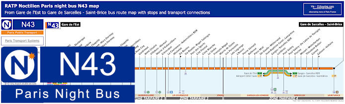
Paris Noctilien night bus N43 map with stops and transport connections
However, this map and its timetables shows the Noctilien Bus route for the RATP line N43 that goes from Gare de l'Est to Gare de Sarcelles - Saint-Brice and has many Noctilien Paris night bus stops on route including to places such as Gare du Nord and others located by this Paris train station including Valenciennes and La Fayette - Dunkerque, but as you can see from the map, it even shows connections to the Fileo buses as well as many other transport services like trams, etc.
Paris night bus line N43 stops:
Gare de l'Est, Valenciennes, La Fayette - Dunkerque, Gare du Nord, Cail - Demarquay, Place de la Chapelle, Departement - Marx Dormoy, Ordener - Marx Dormoy, Les Roses, Boucry, Porte de la Chapelle, Emile Bertin, Porte d'Aubervilliers, Skanderbeg, La Haie Coq, Gardinoux, Aime Cesaire, Villebois - Mareuil, Mairie d'Aubervilliers, Crevecoeur, La Courneuve - Aubervilliers RER, Michelet, Six Routes, Six Routes - Roger Salengro, Parc des Sports, Cite Floreal, Croix Blanche, Le Globe, Francois Begue, Mairie de Stains, Les Parouzets, Leo Lagrange, L'Avenir, Pierre Semard, Bellevue, Plein Midi, De Gaulle - Mitterrand, Jean-Baptiste Corot - Lamartine, Garges - Sarcelles RER, Locheres, Paul Valery, Paul Valery - De Lattre de Tassigny, Piscine, Mozart - Malesherbes, Theodore Bullier, Carnot, Galvani - Voltaire, Gare de Sarcelles - Saint-Brice.
Paris night bus line N43 main transport connections:
Metro Lines: 2, 4, 5, 12. Train Lines: B, D, E, H, K. Tram Lines: T1, T3b, T5. Bus Lines: N01, N02, N13, N14, N41, N42, N44, N45, N140, N141, N142, N143, Fileo Buses.
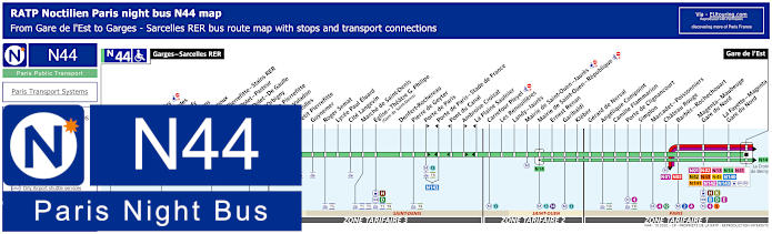
Paris Noctilien night bus N44 map with stops and transport connections
So here you can see the Noctilien night bus N44, which travels from Garges - Sarcelles RER to Gare de l'Est with over 40 bus stops in between at places like Eglise - Theatre G. Phillipe (Gare de Saint-Denis), Porte de Paris, Porte de Clignancourt, plus two different night bus stops around Gare du Nord, or Paris Nord as it is also known, and many others.
Paris night bus line N44 stops:
Garges - Sarcelles RER, Locheres, Paul Valery, Les Flanades, Raoul Dufy, Les Sablons, Jean Grignoux, Gare de Pierrefitte - Stains RER, Etienne Dolet - Pasteur**, Etienne Dolet - De Gaulle*, Alcide d’Orbigny, Mairie de Pierrefitte, Suzanne Valadon, Joncherolles, Petit Pierrefitte, Guynemer, Roger Semat, Lycee Paul Eluard, Cite Langevin, Marche de Saint-Denis, Eglise - Theatre G. Philipe (Gare de Saint-Denis), Denfert-Rochereau, Pierre de Geyter, Porte de Paris*, Porte de Paris - Stade de France**, Pont du Canal**, Ambroise Croizat*, La Plaine Saulnier**, Carrefour Pleyel, Les Renouilleres, Landy - Jaures, Mairie de Saint-Ouen - Jaures, Mairie de Saint-Ouen - Republique, Ernest Renan, Garibaldi, Kleber, Gerard de Nerval, Angelique Compoint, Camille Flammarion, Porte de Clignancourt, Simplon, Marcadet - Poissonniers, Chateau Rouge, Barbes - Rochechouart, Magenta - Maubeuge - Gare du Nord, La Fayette - Magenta - Gare du Nord, Gare de l'Est.
* Bus stop served in direction of Gare de l'Est. ** Bus stop served in direction of Garges - Sarcelles RER.
Paris night bus line N44 main transport connections:
Metro Lines: 2, 4, 5, 12, 13. Train Lines: B, D, E, H, K. Tram Lines: T1, T3b, T5, T8. Bus Lines: N01, N02, N13, N14, N41, N42, N43, N45, N140, N141, N142, N143, Fileo Buses.
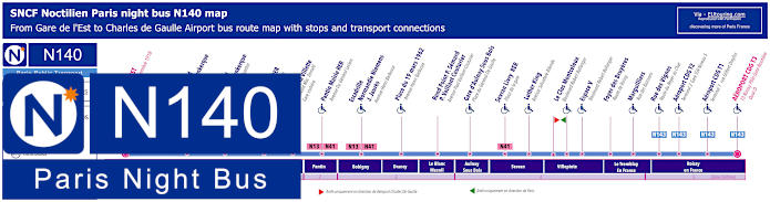
Paris Noctilien night bus N140 map with stops and transport connections
Yet this shows the Paris Noctilien Bus route for the SNCF bus line N140, which travels from Gare de l'Est through to the Aeroport Charles de Gaulle - Terminal 3 Roissypole, however this Paris night bus also stops at Charles de Gaulle Airport CDG 1 and CDG 2 in addition to several others including Gare de Nord. Although if you look at the map and timetables, you will see one stop is located at 170 Rue Lafayette and the other, also classed as the Gare du Nord - Lafayette Dunkerque bus stop, is located at 33 Rue de Saint Quentin, so make sure which direction you need to travel in!
Paris night bus line N140 stops:
Gare de l’Est - Place du 11 Novembre 1918, Gare du Nord - Lafayette Dunkerque - 170 Rue Lafayette*, Gare du Nord - 33 Rue de Saint Quentin**, Rosa Parks RER - Rue Gaston Tessier, Porte de la Villette - Boulevard MacDonald - Gare Routiere, Pantin Mairie RER - Avenue du General Leclerc, Escadrille Normandie Niemens - J. Jaures - Avenue Henri Barbusse, Place du 19 Mars 1962 - Avenue Henri Barbusse, Rond Point P.Semard - Paul Vaillant Couturier - Avenue Paul Vaillant-Couturier***, Gare d’Aulnay-sous-Bois - Place du General de Gaulle, Sevran Livry RER - Place de la Gare, Luther King - Avenue Salvadore Allende, Le Clos Montceleux - Boulevard Robert Ballanger* ***, Espace V - Boulevard Robert Ballanger, Foyer des Bruyeres - Route de Roissy, Marguilliers - Rue des Buissons, Rue des Vignes - Route du Noyer au Chat, Aeroport CDG T2 - Terminal 2 Gare TGV Niveau 5, Aeroport CDG T1 - Terminal 1 Rue Gilbert Dreyfus, Aeroport CDG T3 - T3 Roissy Pole Gare Routiere Quai D.
* Night bus stop served in direction of Charles de Gaulle Airport. ** Night bus stop served in direction of Paris Gare de l'Est. *** Not disabled friendly in direction of CDG Airport.
Paris night bus line N140 main transport connections:
Metro Lines: 4, 5, 7. Train Lines: B, E, P, TGV. Bus Lines: N01, N02, N13, N14, N41, N42, N43, N44, N45, N141, N142, N143.
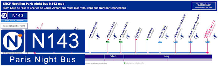
Paris Noctilien night bus N143 map with stops and transport connections
Again the SNCF Noctilien bus line 143 is also a night bus service that runs from Gare de l'Est to CDG Terminal 3 at the Roissypole bus station, and just like above, when you look at the maps and timetables for this night bus route, you will see there are different stops for your chosen direction of travel, such as at the train station of Gare du Nord, which is either on the Rue de St-Quentin or the Rue du Fg St-Denis.
Paris night bus line N143 stops:
Gare de l'Est - Place du 11 Novembre 1918, Gare du Nord - 33 Rue de St-Quentin*, Gare du Nord - Rue du Fg St-Denis**, Porte de la Chapelle - Rue de la Chapelle, St-Denis Porte de Paris - Avenue du President Wilson**, St-Denis Porte de Paris - Rue Casanova*, Cargo Centre - Rue des 2 Cedres**, Cargo Centre - Rue du Rembrai* Rue des Vignes - Rue du Noyer du Chat, Aeroport Charles de Gaulle T2 - Gare TGV niveau 5, Aeroport Charles de Gaulle T1 - Porte 10 Rue Gilbert Dreyfus, Aeroport CDG T3 - Roissy Pole Gare Routiere.
* Stop served in direction of Paris Gare de l'Est. ** Stop served in direction of Charles de Gaulle Airport CDG T3 Roissypole Gare Routiere.
Paris night bus line N143 main transport connections:
Metro Lines: 4, 5, 7. Train Lines: B, E, P, TGV. Bus Lines: N01, N02, N13, N14, N41, N42, N43, N44, N45, N140, N141, N142.
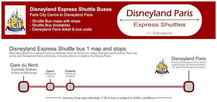
Disneyland Express shuttle bus service from Gare du Nord in Paris to Disneyland Paris theme parks
Here you can see the map with ticketing information and timetables for the Disneyland Express shuttle bus that goes from Gare du Nord train station, also stopping at Opera and Chatelet in Paris, which is a convenient option for all the family that includes the entrance tickets for those who would like a day out at Disneyland Paris theme parks.
Disneyland Express shuttle bus stops: Gare du Nord, Opera, Chatelet, Disneyland Paris.
Disneyland Express shuttle bus and amusement park ticket costs:
Adults (12+ years) Bus + 1 day ticket for 1 Disneyland Park €80.91 Adults (12+ years) Bus + 1 day ticket for 2 Disneyland Parks €98.50 Child (3-11 years) Bus + 1 day ticket for 1 Disneyland Park €74.75 Child (3-11 years) Bus + 1 day ticket for 2 Disneyland Parks €92.34 Child (0 - 2 years) FREE
Disneyland Express shuttle bus timetables, costs and maps available:
Paris Open Tour bus sightseeing tour map for Blue, Red and Green bus lines with stops and timetables
Although here you can see the maps and information for the major Paris sightseeing tour bus company Open Tour, and as you can tell, there are three different routes you can enjoy with this hop on and hop off service, with the Red bus tour line travelling around Montmartre with various pick-up and drop-off points including stop 33 for Gare du Nord at 21 Rue de Dunkerque by the Cafe du Nord virtually facing the train station.
1: Haussmann - Opera - Visitor centre - 13 Rue Auber, 75009 30: Trinite - 32 Rue Mogador, 75009 31: Moulin Rouge - Pigalle - 59 Boulevard de Clichy, 75009 32: Montmartre - Sacre-Coeur - 68 Boulevard de Rochechouart, 75018 33: Gare du Nord - 21 Rue de Dunkerque, 75010 34: Gare de l'Est - 129 Rue du Faubourg St-Martin, 75010 35: Republique - Face au 11 Boulevard Saint-Martin, 75003 36: Bonne Nouvelle - Grand Rex - 36 Boulevard de Bonne-Nouvelle, 75010 37: Grands Boulevards - Hard Rock Cafe - 16 Boulevard Montmartre, 75009
Paris Open Tour bus sightseeing tour maps with stops and timetables:
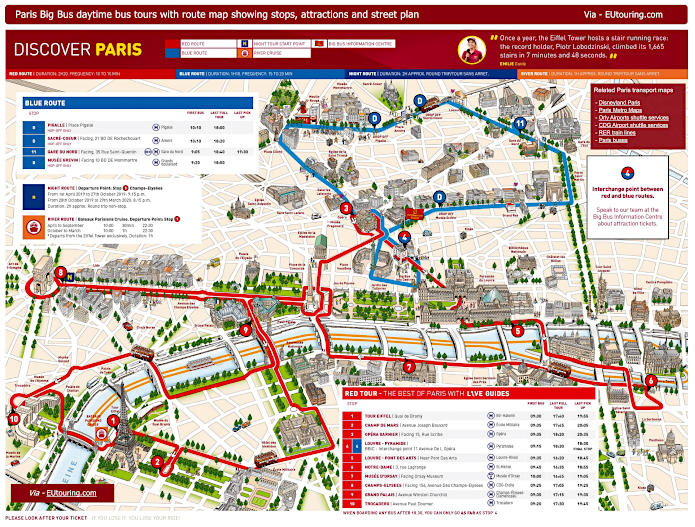
Big Bus Paris sightseeing tour map for Red and Blue bus lines with stops and timetables
But this shows the maps and information for the tour bus operator called Big Bus Paris, and as you can see from the maps with timetables, you would need the Blue Route and stop number 11 to access the Gare du Nord train station. You will find this is the route travelling around the Montmartre area with drop-off points, but is the only stop on this Big Bus route that has as pick-up point, which faces 35 Rue Saint-Quentin, in between the Timhotel Paris Gare du Nord and the Noctilien N43 stop called Rue de Dunkerque.
4: Louvre-Pyramide / Big Bus Information Centre - 11 Avenue de l’Opera (by Big Bus information centre) 11: Gare du Nord - 35 Rue de Saint-Quentin (facing main entrance of Gare du Nord just off Rue de Dunkerque) 51: Pigalle (HOP OFF ONLY) - Place Pigalle - NOTE: This is a hop-off only stop, so you cannot get back on board here. 52: Sacre-Coeur (HOP OFF ONLY) - facing 21 Boulevard de Rochechouart, then walk to the Funicular) - NOTE: This is a hop-off only stop, so you cannot get back on board here. 53: Musee Grevin (HOP OFF ONLY) - 10 Boulevard Montmartre - NOTE: This is a hop-off only stop, so you cannot get back on board here.
Big Bus Paris daytime sightseeing tour maps with stops and timetables:
Gare du Nord plans of public services and access points plus train station map
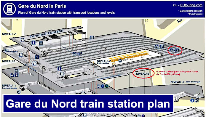
Gare du Nord train station plan of levels and transport access points
However, here you can see a general plan of Gare du Nord train station showing the layout and its different levels (Level is Niveau in French), and you can see the locations of how to get to the Eurostar terminal at Paris Nord, access the various other main line trains, the Metro and regional trains, etc, along with some of the services offered.
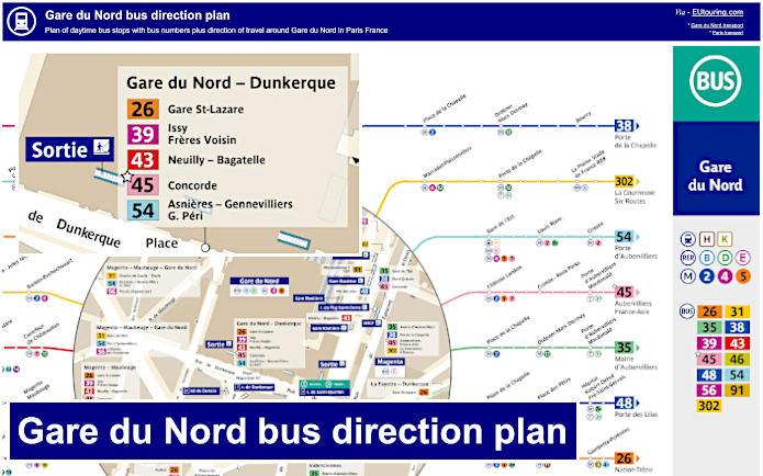
Gare du Nord map of daytime bus stops with direction of travel from the train station
Although the last map for this section shows various day buses around Gare du Nord train station, showing not just what streets they are located on, but also the direction of travel to the bus route terminus points, which is very crucial to ensure you are heading in the right direction to get to other public transport hubs and their connections or numerous tourist attractions in Paris.