How to get to Stade de France in Paris using public transport
Below you will find the different transport options of how to get to Stade de France including route maps and timetables for getting to this famous stadium that hosts numerous sports events along with music and entertainment events. Easily reached from Charles de Gaule airport and transport hubs including the train station of Gare du Nord Paris to Stade de France, in addition to many other options you can choose, these can all be downloaded in PDF or image format to your PC or mobile device for your convenience.
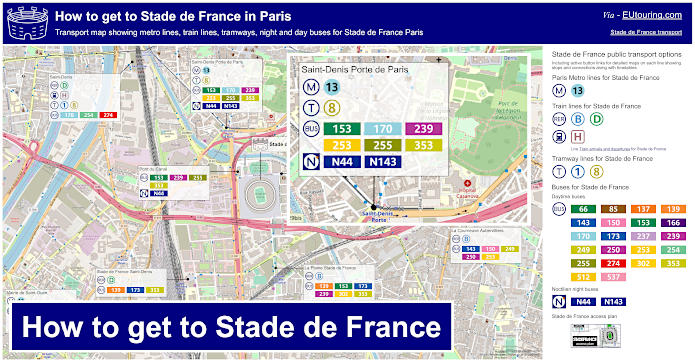
Stade de France transport map with Metro lines, trains, tramways, bus lines with stops, connections and street plan
This first map shows a street plan of Stade de France with numerous different public transport options to choose from, so whether you are travelling in from another country or from Paris itself, the options you have such as trains and buses for getting to a Stade de France event are easy to utilise and below you can discover information on each individual line.
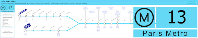
Paris Metro Line 13 map with stations, connections and points of interest
Here you have the maps for Metro Line 13 that travels from Chatillon Montrouge and into Paris itself stopping at key stations of Montparnasse - Bienvenue, Invalides and Gare Saint-Lazare, yet splitting off into two directions, you would need to take the direction of St-Denis Universite and alight at the Saint-Denis - Porte de Paris Metro stop for the Stade de France.
Metro line 13 stops:
St-Denis Universite, Basilique de St-Denis, Saint-Denis - Porte de Paris, Carrefour Pleyel, Mairie de St-Ouen, Garibaldi, Porte de St-Ouen, Guy Moquet, Asnieres - Gennevilliers Les Courtilles, Les Agnettes, Gabriel Peri, Mairie de Clichy, Porte de Clichy, Brochant, La Fourche, Place de Clichy, Liege, Saint-Lazare, Miromesnil, Champs-Elysees - Clemenceau, Invalides, Varenne, Saint-Francois-Xavier, Duroc, Montparnasse - Bienvenue, Gaite, Pernety, Plaisance, Porte de Vanves, Malakoff - Plateau de Vanves, Malakoff - Rue Etienne Dolet, Chatillon Montrouge.
Metro line 13 transport connections:
Metro Lines: 1, 2, 3, 4, 6, 8, 9, 10, 12, 14. Train Lines: C, E, J, L, N. Tram Lines: T1, T3a, T3b, T5, T6, T8.
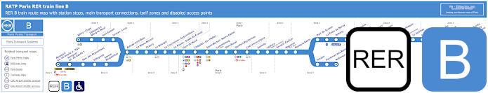
Blue RER B train line map showing station stops, line branches, transport connections and zones
The RER B train line provides a direct transport connection from Charles de Gaulle Airport to Stade de France, and you would need to select the direction of either Robinson or Saint-Remy-les-Chevreuse and alight at La Plaine - Stade de France train station, which is approximately 500 metres from the stadium.
Whereas if you are travelling from Paris to Stade de France, then you could catch the RER B line at Chatelet-les-Halles or Gare de Nord making sure you choose the direction of either Mitry-Claye or Aeroport Charles de Gaulle 2 TGV. Then, as above you would disembark the train at the La Plaine - Stade de France stop.
Paris RER B train line stops:
Mitry–Claye*, Villeparisis - Mitry-le-Neuf, Vert-Galant, Sevran–Livry, Aulnay-sous-Bois, Le Blanc-Mesnil, Drancy, Le Bourget, La Courneuve - Aubervilliers, La Plaine - Stade de France, Gare du Nord, Chatelet - Les Halles, Saint-Michel - Notre-Dame, Luxembourg, Port-Royal, Denfert-Rochereau, Cite Universitaire, Gentilly, Laplace, Arcueil - Cachan, Bagneux, Bourg-la-Reine, Sceaux, Fontenay-aux-Roses, Robinson*, Aeroport Charles de Gaulle 2 - TGV*, Aeroport Charles de Gaulle 1, Parc des Expositions, Villepinte, Sevran - Beaudottes, Parc de Sceaux, La Croix de Berny, Antony (Orly), Fontaine-Michalon, Les Baconnets, Massy - Verrieres, Massy - Palaiseau, Palaiseau, Palaiseau - Villebon, Lozere (Ecole Polytechnique), Le Guichet, Orsay–Ville, Bures-sur-Yvette, La Hacquiniere, Gif-sur-Yvette, Courcelle-sur-Yvette, Saint-Remy-les-Chevreuse*.
* Terminus Points.
Paris RER B train line transport connections:
Metro Lines: 1, 2, 4, 5, 6, 7, 10, 11, 14. Train Lines: A, C, D, E, H, K, TGV, CDG Val, OrlyVal. Tram Lines: T3a, T4, T11. Bus Lines: TVM (14), OrlyBus, RoissyBus.
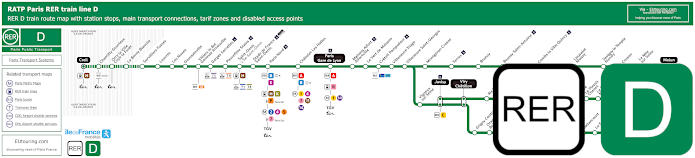
Green RER D train line map showing station stops, line branches, transport connections and zones
You could also catch the RER D line from Gare de Lyon to Stade de France, or from Chatelet-les-Halles and Paris Nord train stations, and requiring the direction of Creil, you would need to get off at the Stade de France - St Denis stop, which is approximately 1100 metres away from the stadium, so a little further than some options.
Paris RER D train line stops:
Creil*, Chantilly - Gouvieux, Orry-la-Ville - Coye-la-Foret, La Borne Blanche, Survilliers - Fosses, Louvres, Les Noues, Goussainville, Villiers-le-Bel - Gonesse - Arnouville, Garges - Sarcelles, Pierrefitte - Stains, Saint-Denis, Stade de France - Saint-Denis, Paris Gare du Nord, Chatelet - Les-Halles, Paris Gare de Lyon, Maisons-Alfort - Alfortville, Le Vert de Maisons, Creteil - Pompadour, Villeneuve - Triage, Villeneuve - Saint-Georges, Montgeron-Crosne, Yerres, Brunoy, Boussy - Saint-Antoine, Combs-la-Ville - Quincy, Lieusaint-Moissy, Savigny-le-Temple - Nandy, Cesson, Le Mee-sur-Seine, Melun*, Vigneux-sur-Seine, Juvisy**, Viry Cahatillon**, Ris - Orangis, Grand-Bourg, Evry - Val de Seine, Grigny Centre, Orangis - Bois de l'Epine, Evry - Courcouronnes (Centre), Le Bras de Fer (Evry Genepole), Corbeil - Essonnes**, Essonnes - Robinson, Villabe, Le Plessis - Chenet, Le Coudray - Montceaux, Saint-Fargeau, Ponthierry - Pringy, Poissise-le-Roi, Vosves, Melun**, Moulin Galant, Mennecy, Ballancourt, La Ferte-Alais, Boutigny, Maisse, Buno Gironville, Boigneville, Malesherbes*.
* Terminus points. ** RER D Transfer points.
Paris RER D train line transport connections:
Metro Lines: 1, 2, 4, 5, 7, 11, 14. Train Lines: A, B, C, E, H, K, P, R, TGV, TER. Tram Lines: T1, T5, T8, T11. Bus Lines: 20, 393, Senlis, TVM (14), Tzen 1.
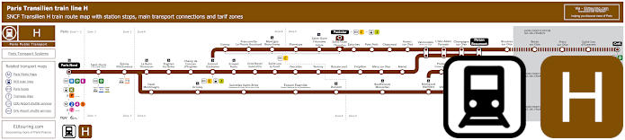
Transilien train line H map showing station stops, line branches, transport connections and zones
Another option if travelling within certain areas of Ile de France is the Transilien Line H train where you would need the stop Saint-Denis, and also going from Paris Nord or Gare du Nord, this is only one stop, but we would like to point out that the Gare de Saint-Denis train station is approximately 1800 metres away from the Stade de France, meaning it would take around a 25 to 30 minute walk.
Paris train line H stops:
Paris Gare du Nord*, Saint-Denis, Epinay - Villetaneuse, La Barre Ormesson, Enghien les Bains, Champ de Courses d'Enghien, Ermont - Eaubonne, Cernay, Franconville - Le Plessis Bouchard, Montigny Beauchamp, Pierrelaye, St-Ouen l'Aumone - Liesse, St-Ouen l'Aumone, Pontoise*, Ermont - Halte, Gros Noyer St-Prix, St-Leu la Foret, Vaucelles, Taverny, Bessancourt, Frepillon, Mery sur Oise, Meriel, Epluches, Pont Petit, Chaponval, Auvers sur Oise, Valmondois, L'Isle Adam Parmain, Champagne sur Oise, Persan Beaumont*, Bruyeres sur Oise, Boran sur Oise, Precy sur Oise, St-Leu d'Esserent, Creil*, Deuil Montmagny, Groslay, Sarcelles St-Brice, Ecouen Ezanville, Domont, Bouffemont - Moisselles, Montsoult - Maffliers, Presles Courcelles, Nointel Mours, Villaines, Belloy St-Martin, Viarmes, Seugy, Luzarches*.
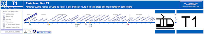
Paris tram line T1 map with tramway stations, transport connections and zones
The train station of Saint-Denis is also a way you can access the tramway line T1 with the stop being called the Saint-Denis - Gare, with this tram line travelling through communes of Gennevilliers, Villeneuve-la-Garenne, Drancy, Bobigny, and Noisy-le-Sec from Asnieres Quatre Routes to Gare de Noisy-le-Sec, not forgetting the Saint-Denis commune, or area, which is where the Stade de France is located.
Paris tram line T1 stops:
Asnieres Quatre Routes, Les Courtilles, Le Luth, Le Village, Timbaud, Gare de Gennevilliers, Parc des Chanteraines, Chemin des Reniers, La Noue, Mairie de Villeneuve-la-Garenne, L’Ile Saint-Denis, Gare de Saint-Denis, Theatre Gerard Philipe, Marche de Saint-Denis, Basilique de Saint-Denis (Hotel de Ville), Cimetiere de Saint-Denis (Sous-Prefecture), Hopital Delafontaine, Cosmonautes, La Courneuve - Six Routes, Hotel de Ville de La Courneuve, Stade Geo Andre, Danton, La Courneuve - 8 Mai 1945, Maurice Lachatre, Drancy - Avenir, Hopital Avicenne, Gaston Roulaud, Escadrille Normandie-Niemen, La Ferme, Liberation, Hotel de Ville de Bobigny (Maison de la Culture), Bobigny - Pablo Picasso (Prefecture - Hotel du Departement), Jean Rostand, Auguste Delaune, Pont de Bondy, Petit Noisy, Gare de Noisy-le-Sec.
Paris tram line T1 transport connections:
Metro Lines: 7, 13. Train Lines: C, D, E, H. Tram Lines: T5, T8.
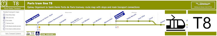
Paris tram line T8 map with tramway stations, transport connections and zones
Travelling from Epinay - Orgemont in the Epinay-sur-Seine commune through Villetaneuse on to Saint-Denis, as you can see from the maps and timetables, the Tram Line T8 terminates at the Saint-Denis - Porte de Paris stop, which is only around 500 metres from Stade de France Paris stadium.
Paris tram line T8 stops:
Epinay Orgemont to Saint-Denis tram T8 stops: Epinay Orgemont, Epinay-sur-Seine - Gare, Gilbert Bonne maison, Lacepede, Rose Bertin (Centre Commercial l'Ilo), Les Beatus, Les Mobiles, Blumenthal, Delaunay-Belleville, Paul Eluard, Saint-Denis - Gare, Pierre De Geyter, Saint-Denis - Porte de Paris.
Villetaneuse Uni to Saint-Denis tram T8 stops:
Villetaneuse Universite, Pablo Neruda, Jean Vilar, Cesar, Delaunay-Belleville, Paul Eluard, Saint-Denis - Gare, Pierre De Geyter, Saint-Denis - Porte de Paris.
Paris tram line T8 transport connections:
Metro Line: 13. Train Lines: C, D, H. Tram Lines: T1, T11.
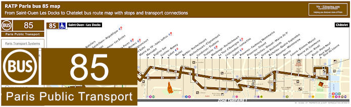
RATP Paris bus line 85 with stops, connections and street plan
So this is the bus line 85 that is one of the transport connections at Chatelet in Paris, which goes through to Saint-Ouen - Les Docks, and as you will see from the bus maps and timetables, there are several stops that are only served in a particular direction, however, there is one bus stop called Mairie de Saint-Ouen, which will get you within reach of the Stade de France.
Paris bus line 85 stops:
Saint-Ouen - Les Docks, Parvis des Bateliers, Mairie de Saint-Ouen - Republique, Ernest Renan, Eugene Lumeau - Les Ecoles, Paul Bert, Marche aux Puces, Michelet - Rosiers, Porte de Clignancourt, Albert Kahn, Mairie du 18e - Jules Joffrin, Marcadet**, Eugene Sue*, Custine - Ramey**, Labat*, Muller, Barbes - Rochechouart**, Rochechouart - Clignancourt, Condorcet - Trudaine*, Trudaine**, Maubeuge - Rochechouart*, La Tour d’Auvergne**, Chateaudun - Lamartine**, Cadet*, Provence - Faubourg Montmartre*, Provence - Drouot**, Richelieu - Drouot - Mairie du 9e**, Grands Boulevards*, Richelieu - Quatre Septembre**, Reaumur - Montmartre, Bourse**, Louvre - Etienne Marcel, Bourse de Commerce, Louvre - Rivoli, Rivoli - Pont Neuf*, Pont Neuf - Quai du Louvre**, Chatelet.
* Stop served in direction of Saint-Ouen - Les Docks. ** Stop served in direction of Chatelet, Paris.
Paris bus line 85 transport connections:
Metro Lines: 1, 2, 3, 4, 7, 8, 9, 11, 12, 13, 14. Train Lines: A, B, D. Tram Line: T3b.
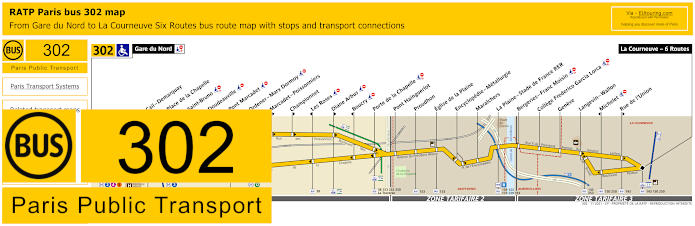
RATP Paris bus line 302 with stops, connections and street plan
Yet if for some reason the RER trains are not running, then you can still get a direct bus from Paris to Stade de France with the RATP bus line 302, which goes from the train station of Gare du Nord to La Plaine - Stade de France RER bus stop, and then continues its journey on to La Courneuvre - Six Routes, yet as you can see from the bus maps and timetables, 2 stops are served only in a particular direction.
Paris bus line 302 stops:
Gare du Nord, Cail - Demarquay, Place de la Chapelle, Saint-Bruno, Doudeauville, Pont Marcadet, Ordener - Marx Dormoy*, Marcadet - Poissonniers**, Championnet**, Les Roses*, Diane Arbus**, Boucry*, Porte de la Chapelle, Pont Hainguerlot, Proudhon, Eglise de la Plaine, Encyclopedie - Metallurgie, Maraichers, La Plaine - Stade de France RER, Bergeries - Franc Moisin, College F. Garcia Lorca, Geneve, Langevin - Wallon, Michelet*, Rue de l'Union**, La Courneuve - Six Routes.
* Stop served in direction of Gare du Nord. ** Stop served in direction of La Courneuve - Six Routes.
Paris bus line 302 transport connections:
Metro lines: 2, 4, 5, 12. Train lines: B, D, E, H, K. Tram lines: T1, T3b. Bus lines: 26, 35, 38, 39, 43, 45, 48, 54, 60, 91, 139, 143, 150, 153, 173, 239, 250, 252, 253, 350, 353, La Traverse, N01, N02, N43, N143.
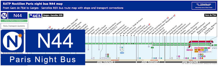
Paris Noctilien night bus N44 map with stops and transport connections
Here you have the Noctilien bus route N44 that goes from Garges - Sarcelles RER to Paris Gare de l'Est train station, and this night bus line has a stop at the Porte de Paris - Stade de France, although there is another at the Pont du Canal bus stop, which is even nearer to get to events at Stade de France being only around 100 metres away.
Paris night bus line N44 stops:
Garges - Sarcelles RER, Locheres, Paul Valery, Les Flanades, Raoul Dufy, Les Sablons, Jean Grignoux, Gare de Pierrefitte - Stains RER, Etienne Dolet - Pasteur**, Etienne Dolet - De Gaulle*, Alcide d’Orbigny, Mairie de Pierrefitte, Suzanne Valadon, Joncherolles, Petit Pierrefitte, Guynemer, Roger Semat, Lycee Paul Eluard, Cite Langevin, Marche de Saint-Denis, Eglise - Theatre G. Philipe (Gare de Saint-Denis), Denfert-Rochereau, Pierre de Geyter, Porte de Paris*, Porte de Paris - Stade de France**, Pont du Canal**, Ambroise Croizat*, La Plaine Saulnier**, Carrefour Pleyel, Les Renouilleres, Landy - Jaures, Mairie de Saint-Ouen - Jaures, Mairie de Saint-Ouen - Republique, Ernest Renan, Garibaldi, Kleber, Gerard de Nerval, Angelique Compoint, Camille Flammarion, Porte de Clignancourt, Simplon, Marcadet - Poissonniers, Chateau Rouge, Barbes - Rochechouart, Magenta - Maubeuge - Gare du Nord, La Fayette - Magenta - Gare du Nord, Gare de l'Est.
* Bus stop served in direction of Gare de l'Est. ** Bus stop served in direction of Garges - Sarcelles RER.
Paris night bus line N44 transport connections:
Metro Lines: 2, 4, 5, 12, 13. Train Lines: B, D, E, H, K. Tram Lines: T1, T3b, T5, T8. Bus Lines: N01, N02, N13, N14, N41, N42, N43, N45, N140, N141, N142, N143, Fileo Buses.
Paris Noctilien night bus N143 map with stops and transport connections
You will find the Noctilien night bus N143 will also get you from Stade de France to Gare de l'Est in Paris plus it stops at Gare du Nord train station as well, and the stop you would need for this direction is St-Denis - Porte de Paris bus stop on the Rue Casanova.
However, as you can see from the maps and timetables, the night bus line N143 also goes to Charles de Gaulle Airport Terminal 3, often referred to as Roissypole, and if travelling from Stade de France to CDG Airport you would need the Saint-Denis - Porte de Paris bus stop located on the Avenue du President Wilson, which is an approximate distance of 550 metres from the stadium.
Paris night bus line N143 stops:
Gare de l'Est - Place du 11 Novembre 1918, Gare du Nord - 33 Rue de St-Quentin*, Gare du Nord - Rue du Fg St-Denis**, Porte de la Chapelle - Rue de la Chapelle, St-Denis Porte de Paris - Avenue du President Wilson**, St-Denis Porte de Paris - Rue Casanova*, Cargo Centre - Rue des 2 Cedres**, Cargo Centre - Rue du Rembrai* Rue des Vignes - Rue du Noyer du Chat, Aeroport Charles de Gaulle T2 - Gare TGV niveau 5, Aeroport Charles de Gaulle T1 - Porte 10 Rue Gilbert Dreyfus, Aeroport CDG T3 - Roissy Pole Gare Routiere.
* Stop served in direction of Paris Gare de l'Est. ** Stop served in direction of Charles de Gaulle Airport CDG T3 Roissypole Gare Routiere.
Paris night bus line N143 transport connections:
Metro Lines: 4, 5, 7. Train Lines: B, E, P, TGV. Bus Lines: N01, N02, N13, N14, N41, N42, N43, N44, N45, N140, N141, N142.
RATP Paris bus line 137 with stops, connections and street plan
The RATP bus line 137 goes from the outskirts of Paris at Porte de Clignancourt - Croisset through to Villeneuve-la-Garenne - ZI Nord and if you are thinking of how to get to the Stade de France, this is one of the options by alighting at the bus stop Mairie de Saint-Ouen, but like above, it is a fair walk to the stadium.
Paris bus line 137 stops:
Port de Clignancourt - Croisset, Porte de Clignancourt, Camille Flammarion, Angelique Compoint, Poissonniers - Cocteau, Gerard de Nerval, Kleber, Garibaldi, Ernest Renan, Mairie de Saint-Ouen - Republique**, Mairie de Saint-Ouen - Dhalenne, Soubise, Quai de Seine, Boulevard Marcel Paul, Quai des Gresillons, Quatre Chemins, Bongarde, Lycee Petiet - Centre Commercial, Maurice Ravel, Boulevard Gallieni - Ecoles, Mairie de Villeneuve-la-Garenne - Gallieni, Mairie de Villeneuve-la-Garenne, Mathilde Milliard, Jean Moulin, Place Paul Herbe, Piscine, Parc Departmental, Villeneuve-la-Garenne - ZI Nord.
** Stop served in direction of Villeneuve-la-Garenne - ZI Nord.
RATP Paris bus line 139 with stops, connections and street plan
Here you can see the RATP Paris bus 139 that goes from the Porte de la Villette by the Parc de la Villette with its entertainment venues, through to Saint-Ouen - Quai de Seine or to La Plaine - Stade de France bus Stop, which is right by the RER train station and approximately 500 metres from the stadium.
Paris bus line 139 stops:
Quai de Seine**, Saint-Ouen - Quai de Seine, Rue Nicolau, Rue Ampere, Carrefour Pleyel, Docteur Finot, Landy - Pleyel, Landy - Cheminots, Stade de France - St-Denis, Avenue des Fruitiers, Wilson - De Pressense, La Plaine - Stade de France, Murger, Saint-Gobain, La Montjoie - Germaine Tillion, Metallurgie, Front Populaire - Proudhon, Front Populaire - Gardinoux, 18, rue du Pilier*, Aubervilliers - France-Asie*, Rue de la Haie Coq**, Gardinoux**, Quai Lucien Lefranc*, Aime Cesaire, Felix Faure - Rue des Ecoles, Karman - Felix Faure, Place Auguste Baron, Porte de la Villette.
* Stop served in direction of Saint-Ouen - Quai de Seine. ** Stop served in direction of Porte de la Villette.
RATP Paris bus line 150 with stops, connections and route plan
Although, as you can see from the bus 150 maps and timetables above, this is another bus route that goes from the outskirts of Paris at the Porte de la Villette through to Gare de Pierrefitte - Stains RER, and on its route the bus line 150 has stops at La Courneuve - Aubervilliers RER and 6 Routes, which will be able to get you to the Stade de France.
Paris bus line 150 stops:
Porte de la Villette, Magenta, Quatre Chemins - Republique, Hopital La Roseraie, Rue des Cites, Andre Karman, Mairie d'Aubervilliers, Crevecoeur, La Courneuve - Aubervilliers RER , Michelet, 6 Routes, 6 Routes - Roger Salengro**, Parc des Sports, Cite Floreal, Croix Blanche, Le Globe, Francois Begue, Mairie de Stains, Les Parouzets, J. Jaures - A. Briand, Gare de Pierrefitte - Stains RER.
** Served in direction of Gare de Pierrefitte - Stains RER.
Paris bus line 150 transport connections:
Metro Line: 7. Train Lines: B, D. Tram Lines: T1, T3b, T11. Bus Lines: 11, 139, 143, 152, 170, 249, 250, 252, 253, 255, 268, 302, 337, 361, Vitavil.
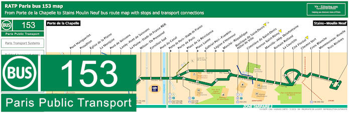
RATP Paris bus line 153 with stops, connections and street plan
Whereas the route for the bus line 153 going from Porte de la Chapelle to Stains - Moulin Neuf has several different stops you could utilise to get you to the Stade de France including at the train station of La Plaine - Stade de France and another called the Porte de Paris - Stade de France, yet the closest bus stop to the stadium is the Pont du Canal bus stop at only around 100 metres away.
Paris bus line 153 stops:
Porte de la Chapelle, Pont Hainguerlot, Proudhon, Eglise de la Plaine, La Montjoie, Pont de Soissons, Landy - Pont de Soissons, La Plaine - Stade de France RER, Wilson - De Pressense, Cornillon Sud, Pont du Canal, Porte de Paris - Stade de France**, Porte de Paris, Place de la Resistance*, Place Lanne**, Gabriel Peri - Franklin*, Legion d'Honneur**, Marche - Republique*, Basilique de Saint-Denis - Hotel de Ville, Cimetiere de Saint-Denis, Avenue Saint-Remy, Marville - Hopital Delafontaine, Romain Rolland, La Courtille, Cite Floreal, Chemin Vert, Croix Blanche, Monmousseau - Renelle, Trois Rivieres, Stains - Moulin Neuf.
* Served in direction of Porte de la Chapelle. ** Served in direction of Stains - Moulin Neuf.
Paris bus line 153 transport connections:
Metro Lines: 12, 13. Train Line: B. Tram Lines: T1, T3b, T8. Bus Lines: 65, 139, 150, 153, 166, 173, 239, 250, 252, 253, 255, 302, 350, 356, La Traverse (518).
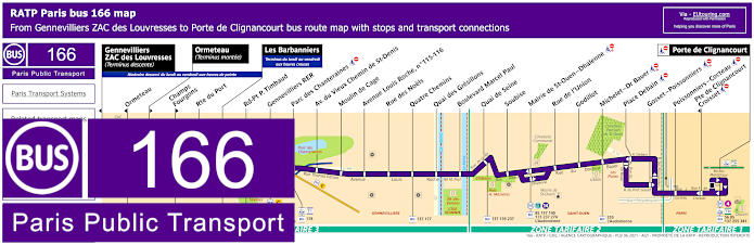
RATP Paris bus line 166 with stops, connections and street plan
So this shows the Paris bus line 166 that goes from the outskirts of Paris at the Porte de Clignancourt through to Les Barbannieers or Ormeteau or Gennevilliers ZAC des Louvresses depending upon the direction of travel and time of day, yet you will see on it bus route there is a stop called Jean Jaures - Mairie, which is at the Marie de Saint-Ouen bus stop approximately 2800 metres from this major events stadium.
Paris bus line 166 stops:
Gennevilliers - ZAC des Louvresses (Terminus descente), Ormeteau*, Ormeteau** (Terminus montee), Champs - Fourgons**, Route de Port, Les Barbanniers, Rond-Point P. Timbaud, Gennevilliers RER, Parc des Chanteraines, Av. du Vieux Chemin de St-Denis, Moulin de Cage, Avenue Louis Roche, No 115-116, Rue des Noels, Quatre Chemins, Quai des Gresillons, Boulevard Marcel Paul, Quai de Seine, Soubise, Mairie de St-Ouen - Dhalenne, Rue de l'Union, Godillot, Michelet - Dr Bauer, Place Debain, Gosset - Poissonniers, Poissonniers - Cocteau, Pte de Clignancourt - Croisset*, Porte de Clignancourt.
* Served in direction of Gennevilliers - ZAC des Louvresses. ** Served in direction of Porte de Clignancourt.
Paris bus line 166 transport connections:
Metro lines: 4, 13, 14. Train line: C. Tram lines: T1, T3b. Bus lines: 56, 85, 137, 138, 139, 140, 173, 177, 178, 237, 238, 255, 274, 340, 341, L'Audonienne (537), Le Bus du Port (538), River Plaza (577).
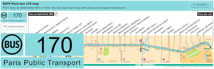
RATP Paris bus line 170 with stops, connections and route plan
Going from the Gare de Saint Denis RER train station through to Paris, Porte des Lilas, you will see that the RATP bus line 170 also has a bus stop at Port de Paris - Stade de France, which you will find is approximately 550 metres from the stadium.
Paris bus line 170 stops:
Gare de Saint-Denis RER, Square de Geyter, Porte de Paris - Stade de France, Hopital, Charles Cros, Rue du Progres, Bergeries - Franc Moisin, Pont du Chemin de Fer, Heurtault, Schaeffer, Mairie d'Aubervilliers, Andre Karman, Rue des Cites, Hopital La Roseraie, Quatre Chemins - Republique, Quatre Chemins - Edouard Vaillant*, La Perouse, Jean Moulin, Pantin RER - Mairie, Centre National de la Danse, Montgolfier, Hoche - Metro, Franklin, D'Estienne d'Orves, Mairie du Pre-Saint-Gervais, Les Marronniers, Jean Jaures, Faidherbe - Belvedere**, Les Bruyeres*, Porte des Lilas.
* Stop served in direction of Gare de Saint-Denis RER. ** Stop served in direction of Porte des Lilas.
Paris bus line 170 main transport connections:
Metro Lines: 3bis, 5, 7, 11, 13. Train Lines: D, E, H. Tram Lines: T1, T3b, T8. Bus Lines: 35, 48, 61, 96, 105, 115, 129, 150, 151, 152, 153, 173, 239, 249, 253, 254, 255, 274, 330, 356, 512.
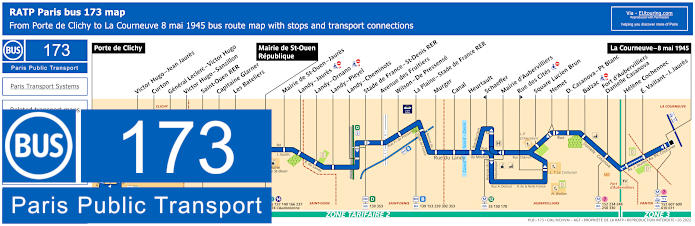
RATP Paris bus line 173 with stops, connections and street plan
Whereas here is the bus route for the Paris bus line 173 that goes between Porte de Clichy and La Courneuve - 8 Mai 1945, and as you will see from the maps and timetables, you could get off at the Stade de France - Saint-Denis RER, or La Plaine - Stade de France RER bus Stop, with this latter one being the shortest distance of the two from this major entertainment and sports venue.
Paris bus line 173 stops:
Porte de Clichy, Victor Hugo - Jean Jaures, Curton, General Leclerc - Victor Hugo, Boise le Pretre, Victor Hugo - Morel, Victor Hugo - Sanzillon, Saint-Ouen RER, Capitaine Glarner, Les Bateliers, Mairie de Saint-Ouen, Jaures - Dhalenne, Landy - Jaures, Landy - Ornano, Landy - Pleyel, Landy - Cheminots, Stade de France - St-Denis RER, Avenue des Fruitiers, Wilson - De Pressense, La Plaine - Stade de France RER, Murger, Canal, Heurtault, Schaeffer, Mairie d’Aubervilliers, Rue des Cites, Square Lucien Brun, Hemet, D. Casanova - Pt Blanc, Balzac, Fort d’Aubervilliers - Danielle Casanova, Helene Cochennec, E. Vaillant - J. Jaures, La Courneuve - 8 mai 1945.
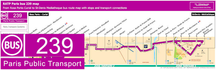
RATP Paris bus line 239 with stops, connections and street plan
The Paris bus route 239 has several different stops you could utilise to get to the Stade de France including the Jesse Owens bus stop at approximately 200 metres away or Delaunay - Rimet bus stop, which is the shortest distance of around only 80 metres, and this is an ideal bus route if you are travelling from Rosa Parks - Curial or Saint-Denis - Mediatheque.
Paris bus line 239 stops:
Rosa Parks - Curial, Rosa Parks, Porte d'Aubervilliers - MacDonald, Skanderbeg**, Parc du Millenaire*, Magasins Generaux, Net Square, Modes et Medias, Gardinoux**, Front Populaire - Proudhon, Metallurgie, La Montjole - Germaine Tillion, Saint-Gobain, Murgot, La Plaine - Stade de France RER, Avenue du Stade de France, Jesse Owens, Delaunay - Rimet, Pont du Canal, Porte de Paris - Stade de France**, Porte de Paris, Place de la Resistance*, Place Lanne**, Gabriel Peri - Franklin*, Marche - Republique*, St-Denis - Mediatheque.
* Stop served in direction of Rosa Parks - Curial. ** Stop served in direction of St-Denis - Mediatheque.
Paris bus line 239 transport connections:
Metro Lines: 12, 13. Train Lines: B, E. Tram Lines: T3b, T8. Bus Lines: 35, 45, 54, 60, 139, 153, 170, 173, 253, 255, 302, 353, 356, 512, La Traverse (518).
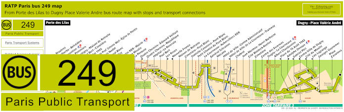
RATP Paris bus line 249 with stops, connections and street plan
However the bus line 249 travels from the outskirts of Paris at Porte des Lilas to Dugny - Place Valerie Andre and from the street maps and timetables you will see that one of the bus stops is La Courneuve - Aubervilliers RER, which is an approximate distance of 2000 metres from the Stade de France.
Paris bus line 249 stops:
Porte des Lilas, Les Bruyeres**, Faidherbe - Belvedere*, Convention, Les Pommiers, Montigny - Maison de Retraite, Paul Bert - Cimetiere, 8 Mai 1945, Lycee Prof. Simone Weil - Eglise de Pantin, Louis Nadot***, Cheval Blanc* ***, Delizy, Pantin RER - Mairie, Jean Moulin, La Perouse, Quatre Chemins - Edouard Vaillant**, Quatre Chemins - Republique, Hopital - La Roseraie, Paul Bert, Les Roses**, Nouvelle France*, Maison de Retraite, Cimetiere - Pont Blanc, Danielle Casanova - Pont Blanc, Petit Chemin du Pont Blanc, La Courneuve - Aubervilliers RER, General Schramm, Mecano, Hotel de Ville - Centre Administratif, Hotel de Ville de La Courneuvre - Tramway*, Chabrol, Jean Mermoz - Henri Barbusse, Cite Waldeck-Rochet, Cimetiere, Centre des Essences, Dugny - La Courneuve, Albert Chardavoine, Place du 16 Aout 1943*, Adolphe Devaux**, Gabriel Peri*, Centre-Ville de Dugny*, Cite du Moulin*, Leo Lagrange*, Georges Guynemer, Place Casanova, Dugny - Place Valerie Andre.
* Stop served in direction of Porte des Lilas. ** Stop served in direction of Dugny - Place Valerie Andre. *** Cheval Blanc stop only served on the first three departures each day travelling in the direction of Porte des Lilas replacing the Louis Nadot bus stop.
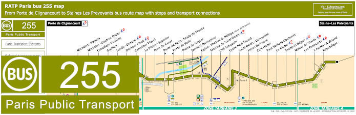
RATP Paris bus line 255 with stops, connections and street plan
In Paris, in the 18th Arrondissement known as the Montmartre area, you have the Porte de Clignancourt stop for bus line 255 that goes through to Stains - Les Prevoyants and on its bus route you have the bus stop Porte de Paris - Stade de France, although, by choosing the Pont du Canal bus stop, this is even closer at around 100 metres away, meaning a very short walk to the stadium.
Paris bus line 255 stops:
Porte de Clignancourt, Michelet - Rosiers, Michelet - Docteur Bauer, Cimetiere Parisien, Godillot, Landy - Ornano, Docteur Finot, Carrefour Pleyel, La Plaine - Saulnier, Pont du Canal, Porte de Paris - Stade de France**, Porte de Paris*, Pierre de Geyter, Denfert-Rochereau, Eglise - Theatre Gerard Philipe (Gare de Saint-Denis), Marche de Saint-Denis, Cite Langevin, Lycee Paul Eluard, Saint-Denis - Universite, Henri Barbusse, Clos Hanot, Paul Vaillant-Couturier, Le Globe, Francois Begue, Mairie de Stains, Les Parouzets, J. Jaures - A. Briand, Republique, Staines - Les Prevoyants.
* Stop served in direction of Porte de Clignancourt. ** Stop served in direction of Staines - Les Prevoyants.
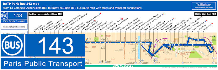
RATP Paris bus line 143 with stops, connections and street plan
Yet this shows the bus line 143 that travels from Rosny-sous-Bois RER through to La Courneuve - Aubervilliers RER, which also serves the RER B train and is approximately 2000 metres from the Stade de France, although, as you can tell from the maps and timetables there are also other bus stops on this route called Langevin - Wallon and the Six Routes - Tramway stop connection to Tram T1 that you can also get off at for the sports stadium.
Paris bus line 143 stops:
La Corneuve - Aubervilliers RER, Saint-Just*, Langevin - Wallon, Rue de l'Union**, Six Routes - Tramway, Paul Verlaine, Le Croult, Jean Mermoz - Henri Barbusse, Passage a Niveau - Jean Mermoz, Verdun, Ecole Normale, Jean Jaures - Division Leclerc*, Le Bourget RER, Edouard Vaillant, Aristide Briand, Jean-P. Timbaud, Mairie de Drancy, Place du 19 Mars 1962, Square de la Liberation, Balzac, Avenue du Bois d'Amour, Chemin du Tonneau, Avenue Marcelle, Pont de Bondy - Anatole France, Pont de Bondy - Avenue de Rosny, Baudin, Alsace - Lorraine, Noisy-le-Sec RER, 11 Novembre 1918, Les Carrouges, Brement**, Brement - De Gaulle*, Rosny 2 - C. Commercial, Leon Blum**, Gabriel Peri - Charles de Gaulle, Eglise de Rosny**, Van Derheyden*, Gardebled*, Copernic*, Rosny-sou-Bois RER.
* Served in direction of La Corneuve - Aubervilliers RER. ** Served in direction of Rosny-sou-Bois RER.
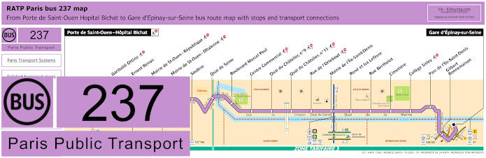
RATP Paris bus line 237 with stops, connections and street plan
Yet the bus line 237 goes from Porte de Saint-Ouen - Hopital Bichat to Gare d'Epinay-sur-Seine where many different buses converge, and although it is an approximate distance of 2800 metres from the Stade de France, it is still within walking distance for those of you travelling from further afield within the Paris region.
Paris bus line 237 stops:
Porte de Saint-Ouen - Hopital Bichat, Garibaldi Ottino, Ernest Renan, Mairie de Saint-Ouen - Republique**, Mairie de Saint-Ouen - Dhalenne, Soubise, Quai de Seine, Boulevard Marcel Paul, Centre Commercial, Quai du Chatelier No 9, Quai du Chatelier No 15, Rue de l'Ortebout, Mairie de l'Ile-Saint-Denis, Rene et Isa Lefevre, Rue Berthelot, Cimetiere, College Sisley, Parc de l'Ile-Saint-Denis, Gilbert - Bonnemaison, Gare d'Epinay-sur-Seine.
** Stop served in direction of Gare d'Epinay-sur-Seine.
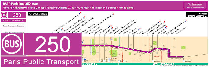
RATP Paris bus line 250 with stops, connections and street plan
So this shows the RATP bus line 250 that travels between Fort d'Aubervilliers and Gonesse - Fontaine Cypierre - ZI, which has several bus stops on route including La Courneuve - Aubervilliers RER and La Courneuve - 6 Routes that means you can access entertainment and sports events at the Stade de France from these areas of the Paris region, Ile de France.
Paris bus line 250 stops:
Fort d'Aubervilliers, Fort d'Aubervilliers - Danielle Casanova, Balzac, Danielle Casanova - Pont Blanc, Petit Chemin du Pont Blanc, La Courneuve - Aubervilliers RER, Michelet, Six Routes - Tramway**, Six Routes - Roger Salengro - Tramway, Parc des Sports, Cite Floreal, Croix Blanche, Le Globe, Louis Bordes, Avenue de Stalingrad No 215, Limite des Departements, Demusois, Croix Buard, Verdun, Carnot, College Pablo Picasso, Rond-Point du Christ, Mairie d'Arnouville, Leon Blum, Lycee, Chemin du Moulin d'Etif, Jean Jaures, La Malmaison, Gonesse - Fontaine Cypierre - ZI.
** Stop served in direction of Gonesse - Fontaine Cypierre - ZI.
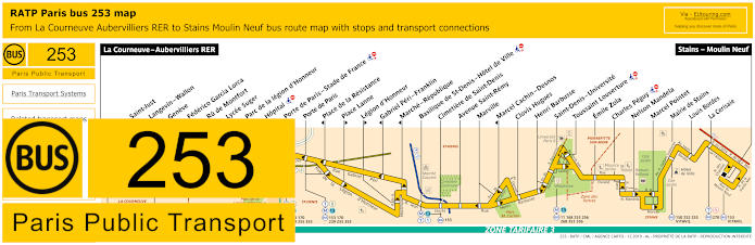
RATP Paris bus line 253 with stops, connections and street plan
Although the bus route for the RATP line 253 goes from La Courneuve - Aubevillers RER to Stains - Moulin Neuf and for stadium events you would need the Porte de Paris - Stade de France bus stop, although we would like to point out that this stop is only served in the direction of Stains and as you can also see from the maps and timetables, unfortunately is not one of the wheelchair friendly bus stops, otherwise a short distance further on and you have the Porte de Paris stop going in the opposite direction.
Paris bus line 253 stops:
La Courneuve - Aubervilliers RER, Saint-Just*, Langevin - Wallon, Geneve, Federico Garcia Lorca, Ru de Montfort, Lycee Suger, Parc de la legion d'Honneur, Hopital*, Porte de Paris - Stade de France**, Porte de Paris, Place de la Resistance*, Place Lanne**, Legion d'Honneur**, Gabriel Peri - Franklin*, Marche - Republique*, Basilique de St-Denis - Hotel de Ville, Cimetiere de Saint-Denis, Avenue Saint-Remy, Marville, Marcel Cachin - Desnos*, Clovis Hugues, Henri Barbusse, Saint-Denis - Universite, Toussaint Louverture, Emile Zola, Charles Peguy, Nelson Mandela, Marcel Pointet, Mairie de Stains, Louis Bordes, La Cerisaie, Stains - Moulin Neuf.
* Stop served in direction of La Courneuve - Aubervilliers RER. ** Stop served in direction of Stains - Moulin Neuf.
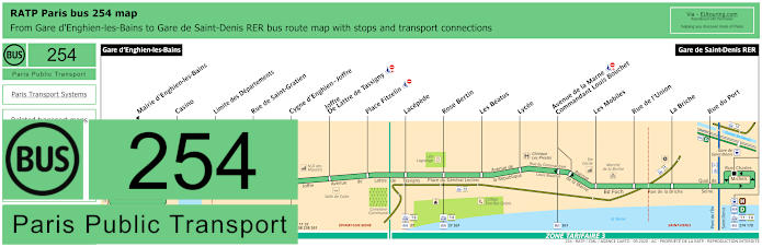
RATP Paris bus line 254 with stops, connections and street plan
Yet if you are travelling by bus from Gare d'Enghien-les-Bains to the Stade de France or the commune of Epinay-sur-Seine, then the RATP bus line 254 has a bus stop at Gare de Saint-Denis, which is also the terminus point, although this is the longest walking distance of around 1800 metres from the stadium and entertainment venue of Stade de France.
Paris bus line 254 stops:
Gare d'Enghien-les-Bains, Mairie d'Enghien-les-Bains*, Casino, Limite des Departements, Rue de Saint-Gratien, Cygne d'Enghien - Joffre, Joffre - D Lattre de Tassigny, Place Fitzelin, Lacepede, Rose Bertin, Les Beatus, Lycee, Avenue de la Marne - Commandant Louis Bouchet, Les Mobiles, Rue de l'Union, La Briche, Rue du Port, Gare de Saint-Denis RER.
* Stop served in direction of Gare d'Enghien-les-Bains.
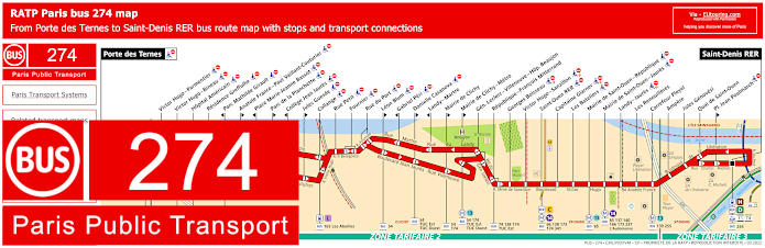
RATP Paris bus line 274 with stops, connections and street plan
However, the RATP Paris bus line 274 travels from Porte des Ternes to Saint-Denis RER, which is actually the Gare de Saint-Denis bus stop, but as we mentioned earlier, this is the train station that has the longest walking distance from Stade de France at around 1800 metres away, but is classed as the main train station for the Saint-Denis area on the outskirts of Paris.
Paris bus line 274 stops:
Porte des Ternes, Victor Hugo–Parmentier, Victor Hugo–Bineau, Hopital Americain, Residence Gre ulhe, Parc Mathilde Girault*, Anatole France–Paul Vaillant-Couturier**, Place Marie-Jeanne Bassot*, Parc de la Planchette**, College Jean Jaures*, Jules Guesde**, Collange, Rue Petit, Fournier, Rue du Port, Leon Blum**, Gabriel Peri*, Danielle Casanova**, Landy-Martre*, Mairie de Clichy**, Mairie de Clichy–Metro**, General Leclerc–Villeneuve–Hopital Beaujon, Republique–Francois Mitterrand, Georges Boisseau, Victor Hugo–Sanzillon, Saint-Ouen RER, Capitaine Glarner, Les Batelier, Mairie de Saint-Ouen–Republique, Mairie de Saint-Ouen–Jaures, Landy–Jaures, Les Renouilleres, Carrefour Pleyel, Ampere, Jules Genovesi, Quai de Saint-Ouen, Place Jean Poulmarch**, Saint-Denis RER.
* Served in direction of Porte des Ternes. ** Served in direction of Saint-Denis RER.
Paris bus line 274 transport connections:
Metro lines: 1, 3, 13, 14. Train lines: C, D, H, L. Tram lines: T1, T8. Bus lines: 43, 54, 66, 74, 82, 85, 93, 94, PC (98), 137, 138, 139, 140, 163, 164, 165, 166, 167, 173, 174, 237, 238, 254, 255, 275, 341, L'Audonienne (537), Les Abeilles, TUC Est (574), TUS Ouest (574).
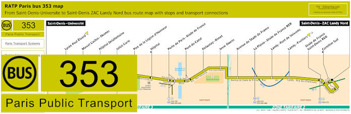
RATP Paris bus line 353 with stops, connections and street plan
Whereas here is the Paris Bus line 353 that goes from Saint-Denis - Universite to Saint-Denis - ZAC Landy Nord and this route has several different bus stops you can utilise to get to stadium events. These include the Stade de France - Saint-Denis RER, La Plaine - Stade de France, Porte de Paris - Stade de France and the closest being the Pont du Canal at around 100 metres, Jesse Owens at approximately 200 metres and the Delaunay - Rimet bus stop at around only 80 metres, meaning this last bus stop provides the shortest walk of all.
Paris bus line 353 stops:
Saint-Denis-Universite, Lycee Paul Eluard, Marcel Cachin - Desnos, Hopital Delafontaine, Joliot Curie, Parc de la Legion d'Honneur, Hopital*, Porte de Paris - Stade de France, Pont du Canal, Delaunay - Rimet, Jesse Owens, Avenue du Stade de France, La Plaine - Stade de France RER, Landy - Pont de Soissons, Landy - Fruitiers, Stade de France - Saint-Denis RER, Cornillon Sud*, Saint-Denis - ZAC Landy Nord.
* Stop served in direction of Saint-Denis-Universite.
Paris bus line 353 transport connections:
Metro Line: 13. Train Lines: B, D. Tram Lines: T1, T8. Bus Lines: 11, 139, 153, 168, 170, 173, 239, 253, 255, 256, 268, 302, 356.
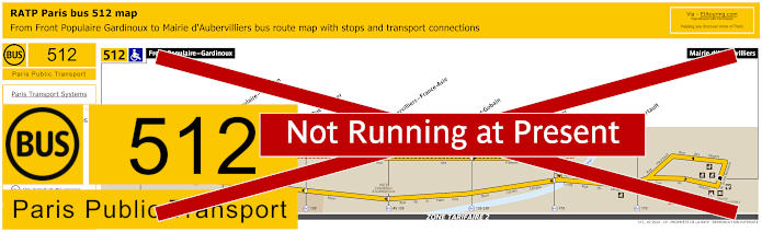
RATP Paris bus line 512 with stops, connections and street plan
Although this shows the maps and timetables for bus line 512, which travels from Front Populaire - Gardinoux to Mairie d'Aubervilliers and as you can see, there are certain bus stops only served in a particular direction, however, to reach the Stade de France from either terminus point you will need the very aptly named bus stop called Canal.
Paris bus line 512 stops:
Front Populaire - Gardinoux, Front Populaire - Proudhon, Saint-Gobain, Canal, Heurtault, Mairie d'Aubervilliers.
Paris bus line 512 transport connections:
Metro Line: 12. Bus Lines: 35, 139, 150, 170, 173, 239.
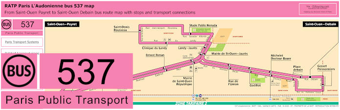
Paris l'Audonienne bus line 537 with stops, connections and street plan
Known as the bus route L'Audonienne, this is also classed as the RATP bus line 537, which travels between Saint-Ouen - Debain to Saint-Ouen - Payret that operates like a circuit meaning that many bus stops are only served in a certain direction, so please take note of the maps and timetables, yet for Stade de France you would need the Mairie de Saint-Ouen or Landy - Jaures bus stops that are approximately 2800 metres away from the stadium.
Paris bus line 537 stops:
Saint-Ouen - Payret, Farcot, Ernest Renan, Mairie de Saint-Ouen Republique, Mairie de Saint-Ouen - Jaures, Clinique du Landy, Saint-Denis - Rousseau, Stade Pablo Neruda, Landy - Jaures, Garibaldi Ottino, Pasteur, Rue de l'Union, Godillot, Michelet Docteur Bauer, Place Debain, Gosset - Poissonniers, Saint-Ouen - Debain.
Paris bus line 537 transport connections:
Metro lines: 13, 14. Bus lines: 85, 137, 140, 166, 173, 237, 255, 274.
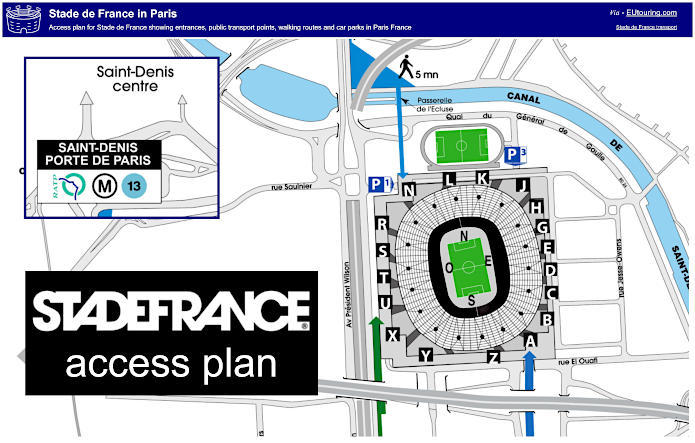
Stade de France plans showing entrances, public transport points, walking routes and car parks
Stade de France plan of entrances, public transport points and walking routes
Now here you have a general map of the Stade de France showing the different stadium entrances along with a rough guide to the three closest train stations including a footbridge over the canal, which shows the closest three train stations with an approximate walking time, although our walking speed must be slower than what this shows!
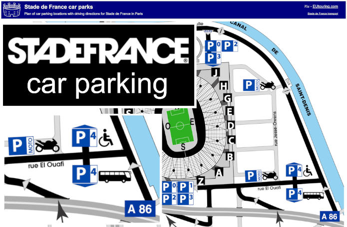
Stade de France plan of car park locations and directions
Yet as you can see, for those of you who are thinking about how to get to Stade de France when travelling in your own vehicle, this also shows the main roads and the car parks for the stadium. Although we would like to point out that you have to book and pay for parking at Stade de France at the time of booking tickets or prior to any sports events or shows. This is due to a limited number of spaces available and security issues, as the Stade de France is a restricted area only accessible to authorised vehicles and those displaying a parking ticket.
Additionally, we would like to point out that car park P1 is closest to gates N, R, S, T, U, X and Y, the stadium car park P2 is closest to gates H, J, K, L, N and R and the Stade de France car park P3 is closest to gate Z, then A, B, C, D, E, G, H, J and K. The P1 and P3 car parks have a maximum clearance height of 2.10 metres and only 2 metres for P2 and they open at 8am on event days, closing at 9pm for matinees and 1am for evening events.
Paris Stade de France car parking plans available: