How to get to Chateau de Vincennes in Paris using public transport
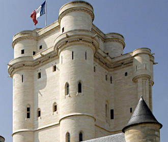
The Chateau de Vincennes is a medieval fort at the gates of Paris that guarded the city and protected kings before being turned into a prison, then it became a fortress protecting Paris and a barracks, which has been fully restored after the major damage during World War II, enabling visitors to admire this historical monument today including the military defence archives. So below you can see how to get to Chateau de Vincennes by public transport with street maps and timetables along with plans and information that can be downloaded by PDF or image format to your PC or mobile device.
Chateau de Vincennes transport map of Metro lines, trains and bus lines with stops, connections and street plan
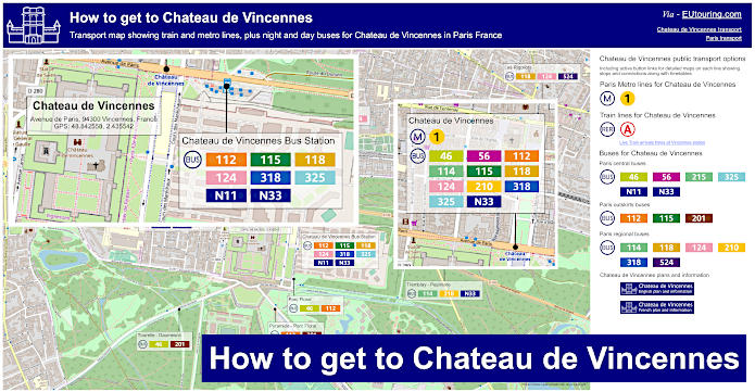
Here you can see a detailed street map showing the Chateau de Vincennes with the public transport options including Metro, trains, buses and night buses located around it, that will all get you within walking distance of the medieval castle and its museum.
How to get to Chateau de Vincennes public transport maps available:
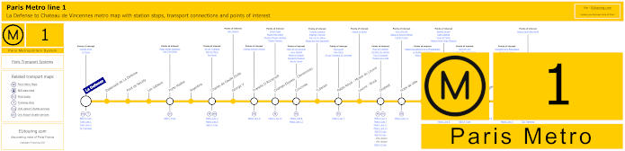
Paris Metro Line 1 map with stations, connections and points of interest
The Paris Metro Line 1 is a very popular way of accessing many tourist attractions including being one of the ways for how to get to Grand Palais, the Palais de Congres, Palais Royal - Musee du Louvre and others, and as you will see from the metro maps, this travels from near the Grande Arche of La Defense to Chateau de Vincennes, also having many metro stops on route with transport connections as well.
Metro Line 1 stops:
La Defense, Esplanade de La Defense, Pont de Neuilly, Les Sablons, Porte Maillot, Argentine, Charles de Gaulle Etoile, George V, Franklin D Roosevelt, Champs-Elysees - Clemenceau, Concorde, Tuileries, Palais Royal - Musee du Louvre, Louvre - Rivoli, Chatelet, Hotel de Ville, Saint-Paul, Bastille, Gare de Lyon, Reuilly - Diderot, Nation, Porte de Vincennes, Saint-Mande, Berault, Chateau de Vincennes.
Metro line 1 main transport connections:
Metro Lines: 2, 4, 5, 6, 7, 8, 9, 11, 12, 13, 14. Train Lines: A, B, C, D, L, R, U. Tram Lines: T2, T3a, T3b.
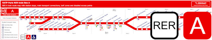
Red RER A train line map showing station stops, line branches, transport connections and zones
Whereas here is the RER A train line that you can catch from central Paris at places such as Chatelet les Halles and Gare de Lyon to various different areas of the Paris region including going the stations of Saint-Germain-en-Laye, Cergy-le-Haut and Marne-la-Vallee Chessy, which is one way of getting to Disneyland Paris, yet as you can see, there is also a stop called Vincennes for getting to the Chateau de Vincennes approximately 800 metres away.
Paris RER A train line stops:
Cergy le Haut*, Cergy Saint-Christophe, Cergy Prefecture, Neuville Universite, Conflans Fin d’Oise, Acheres Ville, Maisons-Laffitte, Sartrouville, Houilles - Carrieres sur Seine, Nanterre Prefecture, La Defense (Grande Arche), Charles de Gaulle Etoile, Auber, Chatelet Les Halles, Paris Gare de Lyon, Nation, Vincennes, Val de Fontenay, Neuilly Plaisance, Bry sur Marne, Noisy le Grand - Mont d’Est, Noisy Champs, Noisiel, Lognes, Torcy, Bussy Saint-Georges, Val d’Europe, Marne la Vallee - Chessy (Parcs Disneyland)*, Poissy*, Acheres - Grand Cormier, Saint-Germain en Laye*, Le Vesinet Le Pecq, Le Vesinet Centre, Chatou Croissy, Rueil Malmaison, Nanterre Ville, Nanterre University, Fontenay sous Bois, Nogent sur Marne, Joinville le Pont, Saint-Maur - Creteil, Le Parc de Saint-Maur, Champigny, La Varenne - Chennevieres, Sucy Bonneuil, Boissy Saint-Leger*.
* Terminus Points.
Paris RER A train line main transport connections:
Metro Lines: 1, 2, 3, 4, 6, 7, 8, 9, 11, 14. Train Lines: B, D, E, J, L, R, U, TGV. Tram Lines: T2, 13. Bus Lines: 393, RoissyBus, TVM (14).
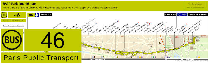
RATP Paris bus line 46 with stops, connections and street plan
Here you can see the RATP Paris bus line 46 that travels from Chateau de Vincennes to Gare de l’Est train station with its numerous transport connections including the RER and SNCF Transilien trains, yet as you will see from the maps and timetables, some of the bus stops are only served in a certain direction.
Paris bus line 46 stops:
Gare de l'Est, Magenta - Saint-Martin**, Verdun, Chateau Landon, Louis Blanc**, Canal Saint-Martin, Colonel Fabien**, Grange aux Belles - Juliette Dodu*, Sambre et Meuse**, Hopital Saint-Louis, Alibert*, Goncourt, Fontaine au Roi, Parmentier - Republique, Saint-Ambroise, Chemin Vert, Voltaire - Leon Blum, Gymnase Japy*, Godefroy Cavaignac**, Charonne - Chanzy, Faidherbe - Chaligny, Reuilly - Diderot, Montgallet, Rue de la Gare de Reuilly, Daumesnil - Felix Eboue, Sidi Brahim, Michel Bizot, Porte Doree - Daumesnil**, Porte Doree, Parc Zoologique, Alphand**, Demi-Lune - Parc Zoologique, Tourelle - Daumesnil, Parc Floral, Chateau de Vincennes.
* Stop served in direction of Chateau de Vincennes. ** Stop served in direction of Gare de l'Est.
Paris bus line 46 main transport connections:
Metro lines: 1, 2, 3, 4, 5, 6, 7, 7bis, 8, 9, 11 Train lines: E, P Tram lines: T3a
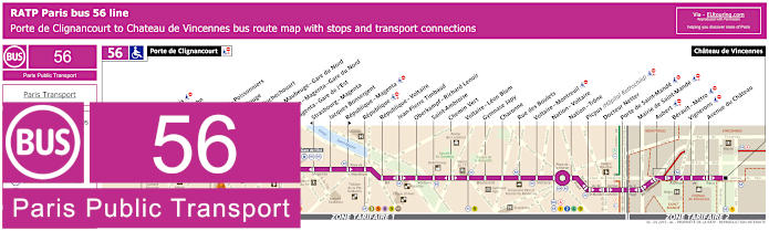
RATP Paris bus line 56 with stops, connections and street plan
This shows the maps and timetables for bus line 56 travelling between Porte de Clignancourt and the Chateau de Vincennes, and as you can see, there are numerous bus stops on route, including those with transport connections at Republique, Nation - Voltaire and La Fayette - Magenta - Gare du Nord, etc, making it easy to get around Paris and beyond.
Paris bus line 56 stops:
Porte de Clignancourt, Mont-Cenis*, Albert Kahn, Simplon, Marcadet - Poissonniers, Chateau Rouge, Barbes - Rochechouart, Magenta - Maubeuge - Gare du Nord, La Fayette - Magenta - Gare du Nord, Magenta - Gare de l’Est, Strasbourg - Magenta*, Jacques Bonsergent, Republique - Magenta*, Republique, Republique - Voltaire, Jean-Pierre Timbaud, Oberkampf - Richard Lenoir, Saint-Ambroise, Chemin Vert, Voltaire - Leon Blum, Gymnase Japy, Charonne, Rue des Boulets, Voltaire - Montreuil, Nation - Voltaire, Nation - Trone, Picpus (Hopital Rothschild), Docteur Netter, Porte de Saint-Mande, Mairie de Saint-Mande, Aubert, Berault - Metro, Vignerons, Avenue du Chateau, Chateau de Vincennes.
* Bus stop is direction dependant.
Paris bus line 56 main transport connections:
Metro Lines: 1, 2, 3, 4, 5, 6, 8, 9, 11, 12. Train Lines: A, B, D, E, H, K. Tram Line: T3b.
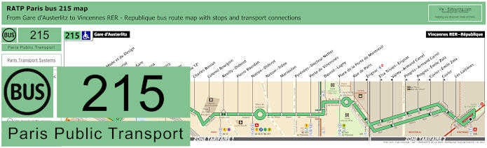
RATP Paris bus 215 map with stops, connections and street plan
Travelling from the heart of Paris at Gare d'Austerlitz train station, the Paris bus line 215 goes to Vincennes RER - Republique bus stop right by the RER A train line and only a short walk to the Chateau de Vincennes, also having many bus stops with transport connections as you can see from the maps and timetables.
Paris bus line 215 stops:
Gare d'Austerlitz, Cite de la Mode et du Design, Vincent Auriol, Quai de la Gare, Bercy - Arena, Gare de Bercy, Dugommier, Mairie du 12e, Charles Bossut, Colonel Bourgoin, Reuilly - Diderot, Pierre Bourdan, Nation - Diderot, Nation - Trone, Marsoulan, Pyrenees - Docteur Netter, Porte de Vincennes, Davout - Lagny, Place de la Porte de Montreuil, Rue de Paris, Erignac*, Elsa Triolet - Erignac**, Valmy - Armand Carrel*, Progres - Armand Carrel**, Progres - Emile Zola**, Cuvier - Emile Zola*, Cuvier**, Les Laitieres, Vincennes RER - Republique.
* Stop served in direction of Gare d'Austerlitz. ** Stop served in direction of Vincennes RER - Republique.
Paris bus line 215 main transport connections:
Metro Lines: 1, 2, 5, 6, 8, 9, 10, 14. Train Lines: A, C. Tram Lines: T3a, T3b. Bus Lines: 24, 26, 46, 56, 57, 61, 63, 71, 77, 86, 87, 89, 91, 318, 325, 351, La Traverse (518).
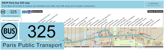
RATP Paris bus 325 map with stops, connections and street plan
The bus line 325 is one of the ways for how to get to Bibliotheque Francois Mitterrand as this route travels from the popular tourist attraction of Chateau de Vincennes to Quai de la Gare, Paris and as you can see from the bus maps and timetables, it goes from Paris through areas of Ivry-sur-Seine, Alfortville and Saint-Mande before reaching Vincennes, so there are various ticket tariff zones.
Paris bus line 325 stops:
Quai de la Gare, Bibliotheque Nationale de France, Emile Durkheim*, Bibliotheque Francois Mitterrand**, Pont de Tolbiac, Thomas Mann, Watt, Bruneseau, Victor Hugo - Bretagne, Jules Vanzuppe, Jean-Jacques Rousseau, Moliere, Insurrection d’Aout 1944, Gambetta, Pont d’Ivry - Rive Gauche, Chinagora*, General de Gaulle, Maisons-Alfort - Ecole Veterinaire, Pont de Charenton, Victor Hugo*, Edmond Nocard**, Charenton - Ecoles*, Avenue de Gravelle, Caserne des Gardes, Demi Lune - Parc Zoologique, Jean Mermoz, Eglise de Saint-Mande, Mairie de Saint-Mande, Saint-Mande - Tourelle, Aubert, Berault-Metro, Vignerons, Avenue du Chateau, Chateau de Vincennes.
* Stop served in direction of Quai de la Gare. ** Stop served in direction of Chateau de Vincennes.
Paris bus line 325 main transport connections:
Metro Lines: 1, 6, 8, 14. Train Lines: A, C. Bus Lines: 24, 25, 46, 56, 62, 64, 71, 86, 89, 103, 104, 107, 111, 112, 114, 115, 118, 124, 125, 132, 180, 181, 210, 318.
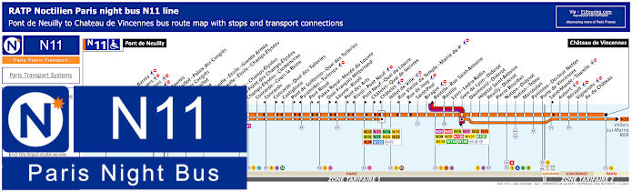
Paris Noctilien night bus N11 map with stops and transport connections
The Noctilien is a night bus service that runs when other public transport has finished for the night, and here you can see the maps and timetables for the Noctilien N11 line travelling between Pont de Neuilly and Chateau de Vincennes, with numerous bus stops on route, many of which are in central Paris for transport connections at Chatelet, Gare de Lyon train station, etc.
Paris night bus line N11 stops:
Pont de Neuilly, Maurice Barres, Les Graviers, Les Sablons, Marche, Andre Maurois*, Porte Maillot - Palais des Congres*, Palais des Congres**, Porte Maillot**, Argentine, Charles de Gaulle - Etoile - Grande Armee, Charles de Gaulle - Etoile - Champs-Elysees, George V, La Boetie - Champs-Elysees, Rond-Point des Champs-Elysees, Champs-Elysees - Clemenceau, Concorde - Cours la Reine, Concorde*, Concorde - Quai des Tuileries**, Castiglione*, Pont de Solferino - Quai des Tuileries**, Pyramides - Tuileries*, Pont Royal**, Palais Royal - Musee du Louvre*, Quai Francois Mitterrand**, Louvre - Rivoli*, Pont des Arts**, Rivoli - Pont Neuf*, Pont Neuf - Quai du Louvre**, Chatelet - Quai de Gesvres**, Chatelet*, Hotel de Ville, Rue Vieille du Temple - Mairie du 4e*, Rue de Jouy**, Saint-Paul, Birague, Bastille - Rue Saint-Antoine, Bastille, Lyon - Ledru-Rollin, Gare de Lyon - Diderot, Daumesnil - Diderot, Hopital Saint-Antoine, Reuilly - Diderot, Pierre Bourdan, Nation - Diderot, Nation - Trone, Marsoulan, Pyrenees - Docteur Netter, Porte de Vincennes, Saint-Mande - Tourelle**, Aubert, Berault, Vignerons, Avenue du Chateau, Chateau de Vincennes.
* In direction of Pont de Neuilly. ** In direction of Chateau de Vincennes.
Paris night bus line N11 main transport connections:
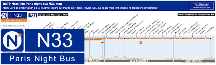
Paris Noctilien night bus N33 map with stops and transport connections
Yet this shows the Noctilien night bus N33 that travels from the Gare de Lyon train station at the bus stop Gare de Lyon - Maison de la RATP to Villiers-sur-Marne - Le Plessis-Trevise RER and on its night bus route you could utilise the stops Vignerons, Avenue du Chateau and Tremblay - Pepiniere or the closest bus stop of Chateau de Vincennes to travel from or to the impressive castle and tourist attraction.
Paris night bus line N33 stops:
Gare de Lyon - Maison de la RATP, Gare de Lyon - Diderot, Daumesnil - Diderot*, Rambouillet, Mairie du 12e, Daumesnil - Felix Eboue, Michel Bizot, Porte Doree - Daumesnil*, Porte Doree**, Montempoivre, Porte de Saint Mande, Mairie de Saint Mande, Aubert, Berault, Vignerons, Avenue du Chateau, Chateau de Vincennes, Tremblay - Pepiniere, Porte Jaune, Nogent-sur-Marne RER - Pierre Semard, Jean Jaures - Chapsal*, Joinville-le-Pont RER**, Carrefour de la Resistance, Verdun, Les Platanes, La Fourchette de Champigny, Aristide Briand - Le Plant, Jean-Baptiste Clement, Plage de Champigny, Guittard, Mairie - Marche, Mairie de Champigny, Rue du Monument, Martelet, La Cascade*, Musee de la Resistance, Fort de Champigny, Les Mordacs, 11 Novembre 1918, Voltaire, Docteur Bring, Villiers-sur-Marne - Le Plessis-Trevise RER.
* Stop served in direction of Gare de Lyon - Maison de la RATP. ** Stop served in direction of Villiers-sur-Marne - Le Plessis-Trevise RER.
Paris night bus line N33 main transport connections:
Metro Lines: 1, 6, 8, 14. Train Lines: A, D, E, R. Tram Line: T3a. Bus Lines: N01, N02, N11, N16, N31, N32, N34, N35, N71, N130, N131, N132, N133, N134, N144.
Chateau de Vincennes Paris city outskirts bus lines
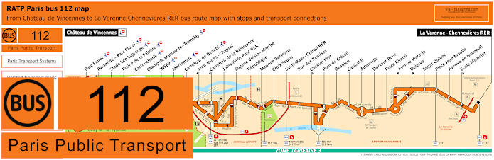
RATP Paris bus line 112 with stops, connections and street plan
Whereas here you have the bus line 112 also run by the transport company RATP, and as you can see from the maps and timetables this goes from La Varenne - Chennevieres RER to Chateau de Vincennes with stops on route that include Pyramide - Parc Floral, although like this particular stop, there are several bus stops not suitable for the disabled and wheelchair users.
Paris bus line 112 stops:
Chateau de Vincennes, Parc Floral, Pyramide - Parc Floral, Stade Leo Lagrange, Plaine de la Faluere, Cartoucherie, Champ de Manoeuvre - Tremblay, INSEP, Mortemart, Carrefour de Beaute, Jean Jaures - Chapsal*, Carrefour de la Resistance, Joinville-le-Pont RER, Eugene Voisin - Marche, Republique, Maurice Berteaux, Croix-Souris, Saint-Maur - Creteil RER, Rue des Remises, Chemin Vert**, Pont de Creteil, Beaujeu, Garibaldi, Adamville, Docteur Roux, Place Rimini, Avenue Victoria*, Delerue**, Edgar Quinet, Place Jean Moulin, Avenue de Bonneuil, Ecole Michelet**, La Varenne - Chennevieres RER.
* Stop served in direction of Chateau de Vincennes. ** Stop served in direction of La Varenne - Chennevieres RER.
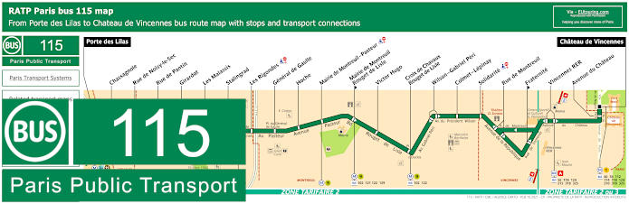
RATP Paris bus line 115 with stops, connections and street plan
Although the timetables and maps for bus line 115 show the route travelling between Porte des Lilas to Chateau de Vincennes, and as you can see, there is also the Vincennes RER bus stop that connects to the RER A train line, which is also within walking distance of the historical fort at the gates of Paris.
Paris bus line 115 stops:
Porte des Lilas, Chassagnole, Rue de Noisy-le-Sec, Rue de Pantin, Girardot, Les Malassis, Stalingrad, Les Rigondes, General de Gaulle, Hoche, Mairie de Montreuil - Pasteur, Mairie de Montreuil - Rouget de Lisle**, Victor Hugo, Croix le Chavaux - Rouget de Lisle, Wilson - Gabriel Peri, Colmet - Lepinay, Solidarite, Rue de Montreuil, Fraternite**, Vincennes RER, Avenue du Chateau, Chateau de Vincennes.
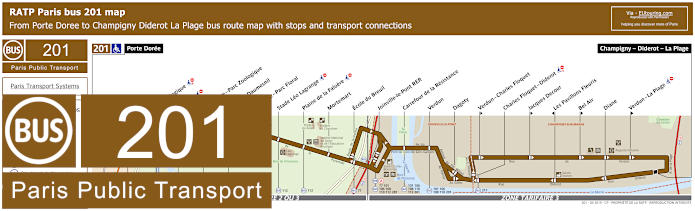
RATP Paris bus line 201 with stops, connections and street plan
The RATP bus line 201 travels from the 12th Arrondissement of Paris at the Porte Doree through to Champigny - Diderot - La Plage with stops at tourist attractions like Parc Zoologique plus this is how to get to Chateau de Vincennes by taking the bus stop Tourelle - Daumesnil or Pyramide - Parc Floral, which are both just a walk from the medieval fort and former royal residence.
Paris bus line 201 stops:
Porte Doree, Parc Zoologique, Alphand*, Demi Lune - Parc Zoologique, Tourelle - Daumesnil, Pyramide - Parc Floral, Stade Leo Lagrange, Plaine de la Faluere, Mortemart, Ecole du Breuil, Joinville-le-Pont RER, Carrefour de la Resistance, Verdun, Dagoty, Verdun - Charles Floquet**, Charles Floquet - Diderot, Jacques Decour**, Les Pavillons Fleuris*, Bel Air**, Diane, Verdun - La Plage**, Champigny - Diderot - La Plage.
* Stop served in direction of Porte Doree. ** Stop served in direction of Champigny - Diderot - La Plage.
Paris bus line 201 main transport connections:
Metro Line: 8. Train Line: A. Tram Line: T3a. Bus Lines: 46, 77, 86, 101, 106, 108, 110, 112, 201, 281, 317, 325.
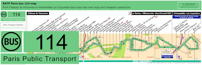
RATP Paris bus line 114 with stops, connections and street plan
Yet here we have the RATP bus line 114 that travels from the medieval castle, Chateau de Vincennes to Le Raincy - Villemomble - Montfermeil RER or further on to Villemomble - Les Coquetiers during off peaks hours in a Monday to Friday, and as you can see from the maps and timetables, there are some bus stops on route only served in a particular direction and operates within the ticket tariff zones 3 and 4.
Paris bus line 114 stops:
Chateau de Vincennes, Tremblay - Pepiniere, Porte Jaune, Nogent-sur-Marne RER - Pierre Semard, Place du General Leclerc, Rue de Beaute, Sous-Prefecture - Jules Ferry, Marche, Hotel des Coignard*, Mairie de Nogent-sur-Marne, Nogent - Le Perreux RER, Le Parc, Ledru-Rollin - General de Gaulle, Bellevue, Bords de Marne, La Maltournee, Neuilly-Plaisance RER, Raspail RER**, Faidherbe - Eglise, Jean Jaures - Victor Hugo*, Alexandre 1er**, Mairie de Neuilly-Plaisance*, Square Jean Mermoz, Cimetiere de Neuilly-Plaisance, Georges Pompidou, Marcel Dassault, Alexander Fleming, Kennedy - Renouilleres, Rue des Hersiers, Etienne Dolet, Bel Air, Avenue de Rosny, Plateau d'Avron - Place de Stalingrad, Caves d'Avron*, Parmentier**, Lucien Berneux*, Marcel Douret**, Hoche**, Marceau*, Chateau de Villemomble, General Leclerc, Le Rancy - Villemomble - Montfermeil RER, Gallieni - Le Raincy - Villemomble - Montfermeil RER***, Marius Gonin***, Charles Hildevert* ***, Allee de la Tour* ***, Villemomble Les Coquetiers***.
* Served in direction of Chateau de Vincennes. ** Served in direction of Le Raincy - Villemomble - Montfermeil RER or Villemomble - Les Coquetiers. *** An off-peak service only on a Monday to Friday.
Paris bus line 114 main transport connections:
Metro Line: 1. Train Lines: A, E. Tram Line: T4. Bus Lines: 46, 56, 112, 113, 115, 116, 118, 120, 121, 124, 203, 210, 214, 221, 317, 318, 325, 601, 602, 603, 605.
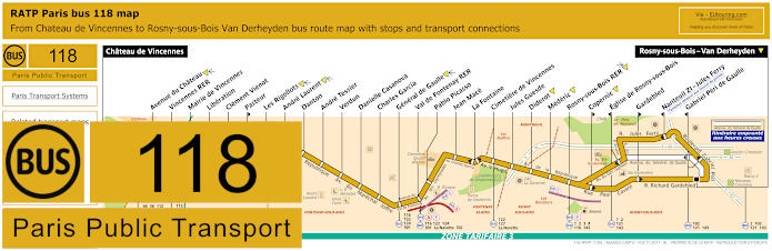
RATP Paris bus line 118 with stops, connections and street plan
However, this is another RATP Paris bus route that has the terminus of Chateau de Vincennes, with the bus line 118 going to Rosny-sous-Bois - Van Derheyden travelling through different communes, or areas of the Paris region including Fontenay-sous-Bois.
Paris bus line 118 stops:
Chateau de Vincennes, Avenue du Chateau, Vincennes RER, Mairie de Vincennes, Liberation, Clement Vienot, Pasteur**, Les Rigollots, Andre Laurent, Danton, Andre Tessier, Verdun, Danielle Casanova, Charles Garcia, General de Gaulle, Val de Fontenay RER, Pablo Picasso, Jean Mace, La Fontaine, Cimetiere de Vincennes, Jules Guesde, Diderot, Mederic, Rosny-sous-Bois RER, Copernic**, Eglise de Rosny-sous-Bois*, Gardebled**, Nanteuil ZI - Jules Ferry*, Gabriel Peri de Gaulle*, Rosny-sous-Bois - Van Derheyden.
* Served in direction of Chateau de Vincennes. ** Served in direction of Rosny-sous-Bois - Van Derheyden.
Paris bus line 118 main transport connections:
Metro Line: 1. Train Lines: A, E. Bus Lines: 1, 2, 3, 4, 46, 56, 102, 112, 114, 115, 116, 121, 122, 124, 127, 143, 210, 215, 301, 318, 325, 702, La Navette (524), Navette Cartoucherie, Navette de l'Hippodrome de Vincennes.
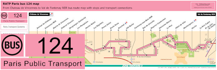
RATP Paris bus line 124 with stops, connections and street plan
The bus line 124 travels from Val de Fontenay RER to Chateau de Vincennes, and just like many bus routes, there are certain stops that are only served in a particular direction as you will see from the maps and timetables, plus some have transport connections like the Vincennes RER bus stop.
Paris bus line 124 stops:
Chateau de Vincennes, Avenue du Chateau, Vincennes RER, Mairie de Vincennes, Diderot-Silvestri, Desgranges - Solidarite, Les Parapluies, Hector Malot, Les Rigollots, Pierre Dulac, Emile Roux**, Boschot*, Ilot Barbe*, Fontenay-sous-Bois RER, Rue de Joinville**, Maurice Couderchet*, Ancienne Mairie**, Le Parc, Hotel de Ville, Montesquieu, Hoche, Le Bois Cadet, Place du General de Gaulle, Val de Fontenay RER.
* Stop served in direction of Chateau de Vincennes. ** Stop served in direction of Val de Fontenay RER.
Paris bus line 124 main transport connections:
Metro Line: 1. Train Lines: A, E. Bus Lines: 46, 56, 112, 114, 115, 116, 118, 122, 127, 210, 301, 318, 325, 702, La Navette (524).
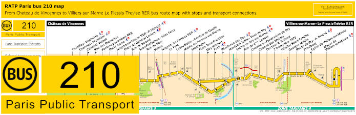
RATP Paris bus line 210 with stops, connections and street plan
As we have mentioned before, the Chateau de Vincennes is classed as an historical castle and fort at the gates of Paris, and here you can see the bus line 210 that travels from the bus station Chateau de Vincennes to Villiers-sure-Marne - Le Plessis-Trveise RER, which goes through different communes including Nogent-sur-Marne and Bry-sur-Marne.
Paris bus line 210 stops:
Chateau de Vincennes, Tremblay - Pepiniere***, Charmes - Pepiniere***, Clement Vienot**, Rue des Pommiers**, Fontenay-sous-bois RER, Porte Jaune***, Nogent-sur-Marne RER - P. Semard***, Place du General Leclerc***, Rue de Beaute, Sous-Prefecture - Jules Ferry, Rue du Port, Viaduc, Nogent - Le Perreux RER***, Le Parc, Ledru-Rollin - General de Gaulle, Mairie du Perreux-sur-Marne, Montaigne, Place Beaufranchet, Guy Moquet**, Foch** ***, Residence des Iles** ***, Marechal Joffre - Pont de Bry***, Mairie de Bry-sur-Marne***, Rue du 4eme Zouave, Cimetiere - Funerarium de Bry, Chemin des Moines, Docteur A. Brillard, 2 Decembre 1870, Hopital Saint-Camille, Georges Melies, Route de Bry - A. Briand***, Friedberg, Eglise de Villiers-sur-Marne*, Mairie de Villiers-sur-Marne***, Villiers-sur-Marne - Le Plessis-Trevise RER.
* Stop served in the direction of Chateau de Vincennes. ** Stop served in teh direction of Villiers-sur-Marne - Le Plessis-Trevise RER. *** Stop not accessible to those with reduced mobility.
Paris bus line 210 main transport connections:
Metro Line: 1. Train Lines: A, E. Bus Lines: 46, 56, 106, 110, 112, 113, 114, 115, 116, 118, 120, 124, 206, 207, 306, 308, 317, 318, 325.
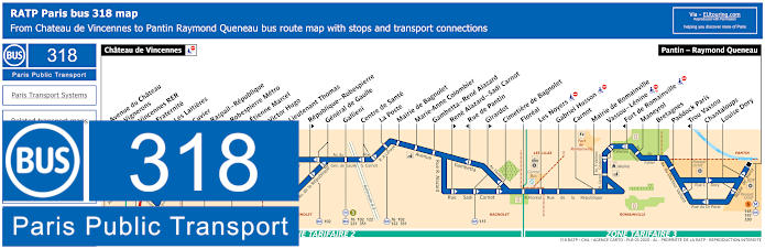
RATP Paris bus line 318 with stops, connections and street plan
Here we have the RATP bus line 318 that operates at various different times all year round between Pantin - Raymond Queneau and Chateau de Vincennes, and as you can see from the maps and timetables, the Vignerons and Vincennes RER bus stops will also get you close to the medieval castle, although some other stops are only served in a particular direction.
Paris bus line 318 stops:
Chateau de Vincennes, Avenue du Chateau, Vignerons, Vincennes RER, Fraternite**, Les Laitieres, Cuvier, Raspail - Republique, Robespierre Metro, Etienne Marcel*, Victor Hugo**, Lieutenant Thomas*, Republique - Robespierre**, General de Gaulle, Gallieni, Centre de Sante, La Poste, Mairie de Bagnolet, Marie-Anne Colombier, Gambetta - Rene Alazard, Rene Alazard - Sadi Carnot**, Rue de Pantin*, Girardot**, Cimetiere de Bagnolet, Floreal, Les Noyers, Gabriel Husson, Carnot, Mairie de Romainville, Vassou - Lenine, Fort de Romainville*, Maneyrol, Bretagnes, Paddock Paris, Trou Vassou*, Chantaloups, Louise Dory, Pantin - Raymond Queneau.
* Served in direction of Chateau de Vincennes. ** Served in direction of Pantin - Raymond Queneau.
Paris bus line 318 main transport connections:
Metro Lines: 1, 3, 5, 9. Train Line: A. Bus Lines: 46, 56, 76, 102, 112, 114, 115, 118, 122, 124, 145, 147, 210, 215, 221, 325, 330, 351.
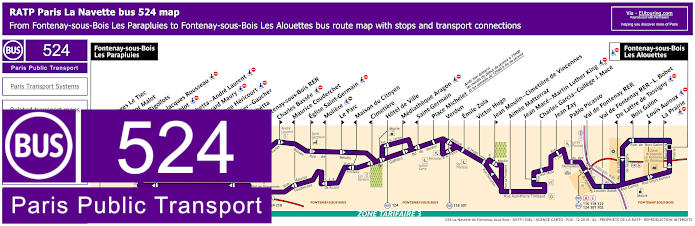
RATP Paris La Navette bus line 524 with stops, connections and street plan
Whereas this is the bus line 524, also referred to as La Navette and Bus Fontenaysien, which travels between Fontenay-sous-Bois - Les Parapluies and Fontenay-sous-Bois - Les Alouettes, although it does not operate between 1st and 15th August, but if you fancy a walk of approximately 2100 metres, then this bus route will also get you to the Chateau de Vincennes.
Paris La Navette bus line 524 stops:
Fontenay-sous-Bois - Les Parapluies, Georges Le Tiec*, Hector Malot, Les Rigollots, Jean-Jacques Rousseau*, Roublot**, Gambetta - Andre Laurent**, Edouard Maury*, Eugene Hericourt**, Mallier - Gaucher*, Gambetta**, Fontenay-sous-Bois RER*, Charles Bassee**, Maurice Couderchet*, Eglise Saint-Germain**, Moliere*, Le Parc**, Maison du Citoyen*, Cimetiere*, Hotel de Ville, Mediatheque Aragon**, Saint-Germain*, Place Michelet***, Verdun, Emile Zola, Victor Hugo, Jean Moulin - Cimetiere de Vincennes**, Aimee Matterraz, Jean Mace - Martin Luther King, Charles Garcia - College J. Mace, Jean Zay, Pablo Picasso, Val de Fontenay RER, Val de Fontenay RER - L. Bobet, De Lattre de Tassigny*, Bois Galon*, Louis Auroux**, La Prairie**, Fontenay-sous-Bois - Les Alouettes.
* Stop served in direction of Fontenay-sous-Bois - Les Parapluies. ** Stop served in direction of Fontenay-sous-Bois - Les Alouettes. *** Not served on a Tuesday until after 3pm and only served on a Saturday from midday.
Paris La Navette bus line 524 main transport connections:
Train Lines: A, E. Bus Lines: 116, 118, 122, 124, 127, 210, 301, 702.
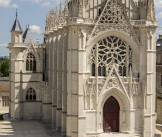
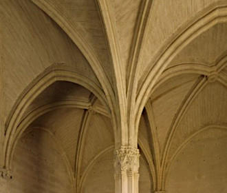
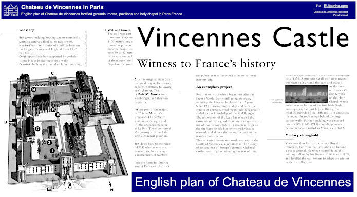
English plan of Chateau de Vincennes fortified grounds, rooms, pavilions and holy chapel
This is the English visitor plan of Chateau de Vincennes that shows what you can discover at this historical fortress, also providing details of various areas and rooms with a bit of history on each, such as the keep, turrets, bell tower, the ground floor with its original well, the holy chapel founded in 1379 and completed in the 1500s, the bed chamber of the king, and much more at this Paris castle, which is the only medieval royal residence that still has its original layout.
Paris Chateau de Vincennes English plans available:
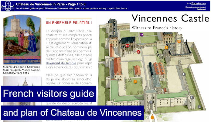
French visitors guide and plan of Chateau de Vincennes fortified grounds, rooms, pavilions and holy chapel
Whereas this is the French plan of Chateau de Vincennes, which is actually a lot more in depth providing the history along with numerous pictures and diagrams plus this is a visitors guide to the medieval fortress, and even for those of you who do not know the French language, it is fascinating to see some of the details that you can discover at this Paris castle.
Paris Chateau de Vincennes French plans available: