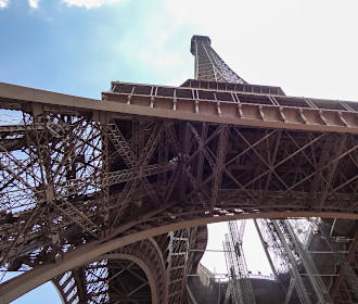
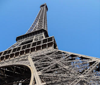
How to get to the Eiffel Tower in Paris using public transport
The Eiffel Tower, spelt Tour Eiffel in French, is the most famous landmark in Paris and the icon of France, so below you will find the different public transport options for how to get to the Eiffel Tower, whether it be by train, bus etc, and with street maps and timetables, these can all be downloaded by PDF or image formats for your home computer or mobile device.
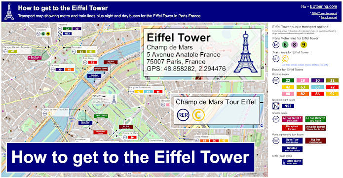
Eiffel Tower transport map of Metro lines, trains, bus lines with stops, connections and street plan
So here we have a street map and plan showing the location of the Eiffel tower and the various different types of public transport that will get you within easy walking distance of the monument including where the bus stops are situated, etc to make getting here far easier.
How to get to Eiffel Tower public transport maps available:
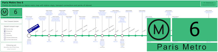
Paris Metro Line 6 map with stations, connections and points of interest
This map shows the Paris Metro line 6 that travels between Nation and Charles de Gaulle Etoile, which is the stop you would need for getting to the Arc de Triomphe, but as you will see, there is a stop called Bir-Hakeim at an approximate distance of 600 metres from the Eiffel Tower.
Additionally, as a point of interest, the Bir-Hakeim metro station is actually elevated and at the end of the platform you can see a large but delicate stained glass window, which was by the American artist Judy Ledgerwood as part of a cultural exchange between Paris, France and Chicago, USA that was put in place in 2008 when the Bir-Hakeim station was renovated.
Metro line 6 stops:
Charles de Gaulle - Etoile, Kleber, Boissiere, Trocadero, Passy, Bir-Hakeim, Dupleix, La Motte-Picquet - Grenelle, Cambronne, Sevres - Lecourbe, Pasteur, Montparnasse - Bienvenue, Edgar Quinet, Raspail, Denfert-Rochereau, Saint-Jacques, Glaciere, Corvisart, Place d'Italie, Nationale, Chevaleret, Quai de la Gare, Bercy, Dugommier, Daumesnil, Bel-Air, Picpus, Nation.
Metro line 6 main transport connections:
Metro Lines: 1, 2, 4, 5, 7, 8, 9, 10, 12, 13, 14. Train Lines: A, B, C, N. Bus Line: OrlyBus.
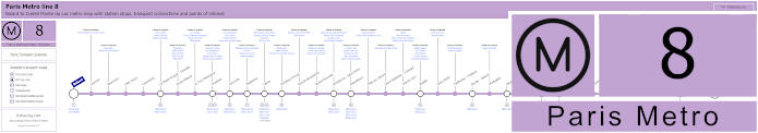
Paris Metro Line 8 map with stations, connections and points of interest
Another option for how to get to the Eiffel Tower is by utilising the Paris Metro line 8 and alighting at the Ecole Militaire stop then taking a walk through the Champ de Mars, which is around 1000 metres, and as you can see from the maps with transport connections, this travels between Balard and Creteil - Pointe du Lac.
Metro line 8 stops:
Balard, Lourmel, Boucicaut, Felix Faure, Commerce, La Motte-Picquet - Grenelle, Ecole Militaire, La Tour-Maubourg, Invalides, Concorde, Madeleine, Opera, Richelieu-Drouot, Grands Boulevards, Bonne Nouvelle, Strasbourg - Saint-Denis, Republique, Filles du Calvaire, Saint-Sebastien - Froissart, Chemin Vert, Bastille, Ledru-Rollin, Faidherbe - Chaligny, Reuilly - Diderot, Montgallet, Daumesnil, Michel Bizot, Porte Doree, Porte de Charenton, Liberte, Charenton - Ecoles, Ecole Veterinaire de Maisons-Alfort, Maisons-Alfort - Stade, Maisons-Alfort - Les Juilliottes, Creteil - L'Echat, Creteil - Universite, Creteil - Prefecture, Creteil - Pointe du Lac.
Metro line 8 main transport connections:
Metro Lines: 1, 3, 4, 5, 6, 7, 9, 10, 11, 12, 13, 14. Train Lines: A, C. Tram Lines: T2, T3a. Bus Lines: RoissyBus, TVM (14).
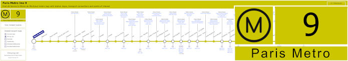
Paris Metro Line 9 map with stations, connections and points of interest
Whereas here you have the Metro line 9 that goes from Pont de Sevres to Mairie de Montreuil with many stops on route including one called Porte de Saint-Cloud, which is how to get to Parc de Princes football stadium. But there is also the Trocadero stop right by the Palais de Chaillot and Trocadero gardens facing opposite the Eiffel Tower where you can get fabulous views of the landmark and walk across the Pont d'Iena to the Eiffel Tower itself at a distance of around 1000 metres, and as you can tell from the maps, this Metro stop also serves line 6 of the Paris Metro.
Metro line 9 stops:
Pont de Sevres, Billancourt, Marcel Sembat, Porte de Saint-Cloud, Exelmans, Michel-Ange - Molitor, Jasmin, Ranelagh, La Muette, Rue de la Pompe, Trocadero, Iena, Alma - Marceau, Franklin D Roosevelt, Saint-Philippe-du-Roule, Miromesnil, Saint-Augustin, Havre - Caumartin, Chaussee d'Antin - La Fayette, Richelieu - Drouot, Grands Boulevards, Bonne Nouvelle, Strasbourg - Saint-Denis, Republique, Oberkampf, Saint-Ambrose, Voltaire, Charonne, Rue des Boulets, Nation, Buzenval, Maraichers, Porte de Montreuil, Robespierre, Croix de Chavaux, Mairie de Montreuil.
Metro line 9 main transport connections:
Metro Lines: 1, 2, 3, 4, 5, 6, 7, 8, 10, 11, 13, 14. Train Lines: A, C, E. Tram Lines: T2, T3b. Bus Line: RoissyBus.
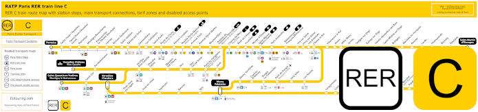
Yellow RER C train line map showing station stops, line branches, transport connections and zones
However, here we have the RER C train line that has various different branches spreading out from the city to the Paris region and tariff zone 5 just like for the terminus point of Versailles Chateau Rive Gauche for one of the Chateau de Versailles transport options. Yet in central Paris there are several train stations you can access including the Champ de Mars Tour Eiffel stop at an approximate distance of 500 metres from the landmark, and below you can see live RER C train arrivals and departures.
Paris RER C train line stops:
Pontoise*, St-Ouen l'Aumone, St-Ouen l'Aumone - Liesse, Pierrelaye, Montigny Beauchamp, Francoville - Le Plessis-Bouchard, Cernay, Ermont Eaubonne, St-Gratien, Epinay-sur-Seine, Gennevilliers, Les Gresillons, St-Ouen, Porte de Clichy, Pereire Levallois, Neuilly - Porte Maillot (Palais des Congres), Avenue Foch, Avenue Henri Martin, Boulainvilliers, Avenue du Pdt Kennedy (Maison de Radio France), Champ de Mars (Tour Eiffel), Pont d'Iena, Invalides, Musee d'Orsay, St-Michel (Notre Dame), Paris Gare d'Austerlitz, Bibliotheque Francois Mitterrand, Ivry-sur-Seine, Vitry-sur-Seine, Les Ardoines, Choisy le Roi, Villeneuve le Roi, Ablon, Athis Mons, Juvisy, Savigny-sur-Orge, Epinay-sur-Orge, Ste-Genevieve des Bois, St-Michel-sur Orge, Bretigny, Marolles en Hurepoix, Bouray, Lardy, Chamarande, Etrechy, Etampes, St-Martin d'Etampes*, Versailles Chateau Rive Gauche*, Porchefontaine, Viroflay Rive Gauche, Chaville - Velizy, Meudon - Val Fleury, Issy, Issy - Val de Seine, Pont du Garigliano (Hopital Europeen Georges Pompidou), Javel, St-Quentin en Yvelines*, St-Cyr, Versailles Chantiers**, Petit Jouy les Loges, Jouy en Josas, Vauboyen, Bievres, Igny, Massy Palaiseau**, Massy Verrieres, Chemin d'Antony, Rungis La Fraternelle, Pont de Rungis (Aeroport d'Orly), Orly Ville, Les Saules, Longjumeau, Chilly Mazarin, Gravigny Balizy, Petit Vaux, La Norville (St-Germain les Arpajon), Arpajon, Egly, Breuillet (Bruyeres le Chatel), St-Cheron, Sermaise, Dourdan, Dourdan la Foret*.
* Terminus Points. ** RER C Transfer Points.
Paris RER C train line main transport connections:
Metro Lines: 1, 2, 3, 4, 5, 6, 8, 9, 10, 12, 13, 14. Train Lines: B, D, H, J, N, U, TGV, TER. Tram Lines: T1, T2, T3a, T3b, T6, T7, T8, T9, T11, T13. Bus Lines: 183, 393, PC (98), TVM (14).
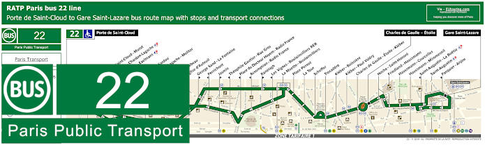
RATP Paris bus line 22 with stops, connections and street plan
The RATP bus line 22 goes from Porte de Saint-Cloud through to Gare Saint-Lazare, although in certain instances it only goes to Charles de Gaulle - Etoile, which is one of the transport options of how to get to the Arc de Triomphe, another famous tourist attraction, but getting back to the Eiffel Tower, you will see from the maps and timetables there is a bus stop on route called Trocadero, where you can then enjoy the elevated views before walking down the Trocadero Gardens and across the Pont d'Iena to the Tour Eiffel.
Paris bus line 22 stops:
Porte de Saint-Cloud, Porte de Saint-Cloud - Murat, Versailles - Chardon-Lagache, Versailles - Exelmans**, Jouvenet*, Victorien Sardou**, Chardon-Lagache - Molitor*, Wilhem**, Pont Mirabeau**, Eglise d’Auteuil, George Sand - La Fontaine**, Perrichont*, Jasmin**, Theophile Gautier - Rue Gros*, Place du Docteur Hayem - Radio France*, Assomption - Radio France*, Ranelagh**, Les Vignes - Boulainvilliers RER*, La Muette - Boulainvilliers, Place Possoz, La Tour, Scheffer, Trocadero, Kleber - Boissiere, Kleber - Paul Valery, Charles de Gaulle - Etoile - Kleber, Charles de Gaulle - Etoile, Hoche - Saint-Honore, Friedland - Haussmann, Haussmann - Courcelles, Haussmann - Miromesnil, Saint-Augustin - La Boetie*, Saint-Augustin, Pasquier - Anjou*, Gare Saint-Lazare.
* Stop served in direction of Porte de Saint-Cloud. ** Stop served in direction of Gare Saint-Lazare.
Paris bus line 22 main transport connections:
Metro Lines: 1, 2, 3, 6, 9, 10, 12, 13, 14. Train Lines: A, C, E, J, L.
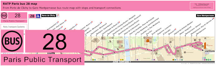
RATP Paris bus 28 map with stops, connections and street plan
Here we have the maps and timetables for bus line 28, which is a convenient way to get to the Eiffel tower as it goes in one direction from the Porte de Clichy to Gare Saint-Lazare train station and has a bus stop at Ecole Militaire on route, or alternatively you could catch this bus from the other terminus point of Gare Montparnasse train station, with both of these stations having numerous transport connections along with others at bus stops in between.
Paris bus line 28 stops:
Porte de Clichy, Berthier - Rostropovitch, Rostropovitch - Pont Teresa, Pont Cardinet, Legendre, Rome - Batignolles, Europe, Gare Saint-Lazare, Saint-Augustin, La Boetie - Miromesnil, Haussmann - Miromesnil, Matignon - Saint-Honore, Saint-Philippe-du-Roule, Rond-Point des Champs-Elysees - Matignon, Rond-Point des Champs-Elysees - Roosevelt, Rond-Point des Champs-Elysees, Palais de la Decouverte, Pont des Invalides - Place de Finlande, La Tour Maubourg - Saint-Dominique, Invalides - La Tour Maubourg, Rue Cler, Ecole Militaire, Duquesne-Lowendal, El Salvador, Breteuil, Hopital des Enfants Malades, Maine - Vaugirard, Montparnasse - Alencon, Montparnasse - Rue de l’Arrivee, Montparnasse, Gare Montparnasse.
Paris bus line 28 main transport connections:
Metro Lines: 1, 2, 3, 4, 6, 8, 9, 10, 12, 13, 14. Train Lines: C, E, J, L, N. Tram Line: T3b.
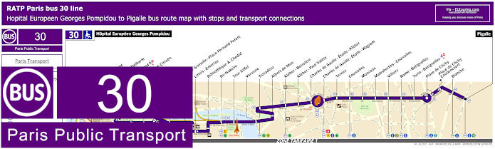
RATP Paris bus line 30 with stops, connections and route plan
The RATP bus 30 has a route going from Pigalle through to Hopital Europeen Georges Pompidou and as you can see from the maps and timetables, there are a few bus stops that you could utilise to reach the Eiffel Tower including Bir-Hakeim and Trocadero, although the aptly named Tour Eiffel bus stop is the closest you can get being right at the base of the tower by the Pont d'Iena.
Paris bus line 30 stops:
Hopital Europeen Georges Pompidou, Rue Leblanc, Leblanc - Delbarre*, Place Balard, Parc Andre Citroen, Cauchy, Javel, Pont de Grenelle-Place Fernand Forest*, Linois - Emeriau*, Bibliotheque A. Chedid*, Bir-Hakeim, Tour Eiffel, Varsovie, Trocadero, Albert de Mun, Kleber - Boissiere, Kleber - Paul Valery, Charles de Gaulle - Etoile - Kleber, Charles de Gaulle - Etoile - Wagram, Ternes, Courcelles, Monceau, Malesherbes - Courcelles, Villiers, Rome - Batignolles, Turin - Batignolles, Place de Clichy, Place de Clichy - Caulincourt**, Blanche, Pigalle.
* Served in direction of Pigale. ** Served in direction of Hopital Europeen Georges Pompidou.
Paris bus line 30 main transport connections:
Metro Lines: 1, 2, 3, 6, 8, 9, 10, 12, 13. Train Lines: A, C. Tram Line: T3a.
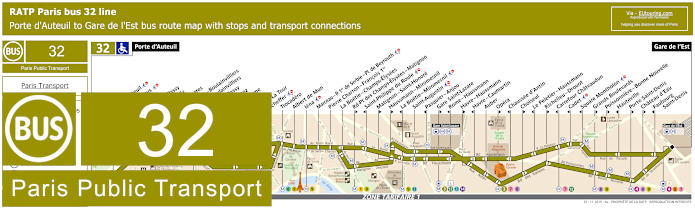
RATP Paris bus line 32 with stops, connections and street plan
Here you can see the bus line 32 travelling from Porte d'Auteuil, which is one of the ways of getting to Hippodrome de Longchamp, through to Gare de l'Est, and as you can see from the maps and timetables, some bus stops are only served in a particular direction, but to reach the Eiffel Tower you could choose the Trocadero bus stop or the Iena stop, both of which are on the opposite side of the River Seine to this historical monument.
Paris bus line 32 stops:
Porte d'Auteuil, Gare d’Auteuil**, Alfred Capus, Raffet, Porte de Passy, Louis Boilly**, Avenue Ingres*, La Muette - Boulainvilliers, Passy - Boulainvilliers**, Place de Passy**, Place Possoz*, Jean Bologne**, La Tour*, Passy - La Tour**, Scheffer, Trocadero, Albert de Mun, Iena, Marceau - P. 1er de Serbie - Pl. de Beyrouth, Pierre Charron - Francois 1er, La Boetie - Champs-Elysees, Rd-Pt des Champs-Elysees - Matignon**, Saint-Philippe du Roule*, Matignon - Saint-Honore**, Haussmann - Miromesnil**, La Boetie - Miromesnil*, Saint-Augustin, Pasquier - Anjou*, Gare Saint-Lazare**, Rome - Haussmann*, Havre - Haussmann**, Havre - Caumartin*, Auber, Opera**, Chaussee d'Antin*, Choiseul**, Le Peletier - Haussmann*, Richelieu - Drouot**, Carrefour Chateaudun*, Cadet*, Square Montholon*, Grands Boulevards**, Poissonniere - Bonne Nouvelle**, Hauteville*, Porte Saint-Denis**, Chateau d’Eau**, Faubourg - Saint-Denis*, Gare de l'Est.
* Stop served in direction of Porte d'Auteuil. ** Stop served in direction of Gare de l'Est.
Paris bus line 32 main transport connections:
Metro Lines: 1, 3, 4, 5, 6, 7, 8, 9, 10, 12, 13, 14. Train Lines: C, E, J, L, P.
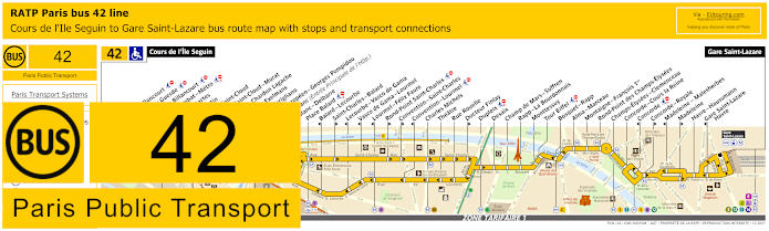
RATP Paris bus line 42 with stops, connections and street plan
This shows the maps and timetables for bus line 42 that travels between Cours de l'Ile Seguin and Gare Saint-Lazare train station and as you can see, there are different stops you can utilise to get you to the Eiffel Tower, including the Tour Eiffel stop and two located either side of the Champ de Mars gardens at the Avenue Joseph Bouvard, which are called the Champ de Mars - Suffren stop and the Rapp - la Bourdonnais bus stop.
Paris bus line 42 stops:
Cours de l'Ile Seguin, Parch de Billancourt, Place Jules Guesde, Marche de Billancourt, Marcel Sembat - Metro, Rene Descartes, Henri Martin, Porte de Saint-Cloud, Porte de Saint-Cloud-Murat, Versailles - Chardon Lagache, Versailles Exelmans, Pont du Garigliano, Hopital Europeen - Georges Pompidou, Rue Leblanc (Entree Principale de l'Hop.), Leblanc - Delbarre**, Place Balard, Balard - Lecourbe*, Saint-Charles - Balard**, Lecourbe - Vasco de Gama*, Vasco de Gama - Lourmel*, Lourmel - Felix Faure*, Rond-Point Saint-Charles**, Convention - Saint-Charles**, Convention - Lourmel*, Charles Michels, Theatre, Rue Rouelle, Docteur Finlay**, Dupleix, Desaix, Champ de Mars - Suffren, Rapp - La Bourdonnais, Monttessuy, Tour Eiffel, Bosquet - Rapp, Alma - Marceau, Montaigne - Francois 1er, Rond-Point des Champs-Elysees, Champs-Elysees - Clemenceau, Concorde - Cours la Reine, Concorde*, Concorde - Royale**, Madeleine - Malesherbes*, Madeleine*, Havre - Haussmann, Gare Saint-Lazare - Havre*, Gare Saint-Lazare.
* Stop served in the direction of Cours de l'Ile Seguin. ** Stop served in the direction of Gare Saint-Lazare.
Paris bus line 42 main transport connections:
Metro Lines: 1, 3, 6, 8, 9, 10, 12, 13, 14. Train Lines: C, E, J, L. Tram Line: T3a.
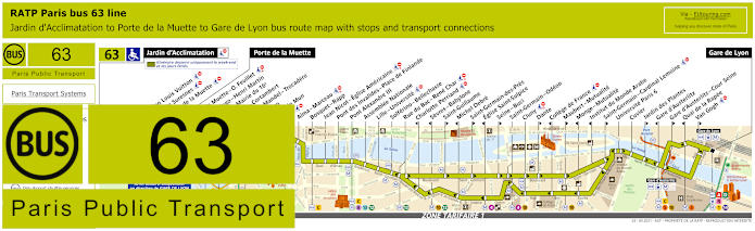
RATP Paris bus 63 map with stops, connections and street plan
Whereas here you have the maps and timetables for bus route 63 that travels from the Paris Gare de Lyon train station to Porte de la Muette and at weekends and public holidays further on to the Jardin d'Acclimatation, and as you can tell, this bus line has bus stops at Georges Mandel - Trocadero and Trocadero, both of which are within easy walking distance of the Eiffel Tower by going passed the Palais de Chaillot and through the gardens, then over the River Seine.
Paris bus line 63 stops:
Jardin d'Acclimatation*, Fondation Louis Vuitton*, Route de Suresnes*, Pelouse de la Muette*, Porte de la Muette, Pte de la Muette - Octave Feuillet, Victor Hugo - Henri Martin, Pompe - Mairie du 16e, Sablons - Cortambert, Georges Mandel - Trocadero, Trocadero, Albert de Mun, Iena, Alma - Marceau, Bosquet - Rapp, Jean Nicot - Eglise Americaine, Pont des Invalides - Place de Finlande, Pont Alexandre III, Assemblee Nationale, Lille - Universite, Solferino - Bellechasse, Rue du Bac - Rene Char, Charlotte Perriand***, Sevres - Babylone***, Saint-Guillaume**, Michel Debre***, Saint-Germain-des-Pres**, Eglise Saint-Sulpice***, Seine - Buci**, Saint-Germain - Odeon, Cluny, Dante**, College de France***, Maubert - Mutualite**, Monge - Mutualite***, Institut du Monde Arabe***, Saint-Germain - Cardinal Lemoine**, Universite Paris 6, Cuvier, Jardin des Plantes**, Gare d'Austerlitz***, Gare d'Austerlitz - Cour Seine**, Quai de la Rapee***, Van Gogh**, Gare de Lyon.
* Only served on weekends, French public holidays and during school holidays. ** Stop served in direction of Paris Gare de Lyon. *** Stop served in direction of Jardin d'Acclimatation and Porte de la Muette.
Paris bus line 63 main transport connections:
Metro lines: 1, 4, 5, 6, 8, 9, 10, 12, 13, 14. Train lines: A, C, D, R.
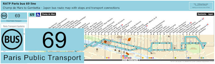
RATP Paris bus line 69 with stops, connections and street plan
So this is the bus line 69 that starts at the Champ de Mars very close to the Eiffel Tower and then travels through to Gambetta - Japon and on its bus route you will find numerous bus stops that are only served in a particular direction, so please take note of the bus 69 maps carefully, yet many go to other tourist attractions and offer transport connections to easily get around Paris and beyond.
Paris bus line 69 stops:
Champ de Mars, Rapp - La Bourdonnais, Champ de Mars - La Bourdonnais*, Bosquet - Grenelle*, Bosquet - Saint-Dominique**, Saint-Pierre du Gros Caillou, Invalides - La Tour-Maubourg*, La Tour-Maubourg - Saint-Dominique**, Esplanade des Invalides, Bourgogne, Grenelle - Bellechasse*, Solferino - Bellechasse, Musee d’Orsay*, Rue du Bac - Rene Char, Pont Royal - Quai Voltaire**, Henry de Montherlant*, Pont du Carrousel - Quai Voltaire*, Pont Royal**, Quai Francois Mitterrand**, Musee du Louvre*, Palais Royal - Musee du Louvre*, Pont des Arts**, Louvre - Rivoli* ***, Pont Neuf - Quai du Louvre**, Rivoli - Pont Neuf*, Chatelet*, Chatelet - Quai de Gesvres**, Hotel de Ville, Eglise Saint-Gervais**, Rue Vieille du Temple - Mairie du 4e*, Rue de Jouy** ***, Saint-Paul, Birague, Bastille - Rue Saint-Antoine, Bastille - Roquette**, Beaumarchais*, Breguet - Sabin**, Richard Lenoir*, Commandant Lamy**, Popincourt, Chemin Vert - Parmentier*, Voltaire - Leon Blum, Saint-Maur - Servan***, Roquette - Pere Lachaise, Folie-Regnault - Chemin Vert* ***, Pere Lachaise**, Auguste Metivier*, Muriers, Martin Nadaud***, Gambetta, Gambetta - Japon.
* Stop served in direction of Champ de Mars. ** Stop served in direction of Gambetta - Japon. *** Not accessible to those with reduced mobility.
Paris bus line 69 main transport connections:
Metro Lines: 1, 2, 3, 3bis, 4, 5, 7, 8, 9, 11, 12, 13, 14. Train Lines: A, B, C, D.
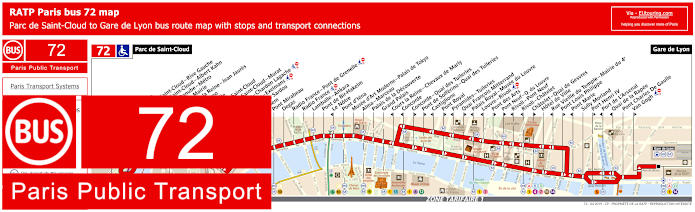
RATP Paris bus 72 map with stops, connections and street plan
Although, the Paris bus line 72 goes from Parc de Saint-Cloud through to Gare de Lyon train station, and as you can see from the maps and timetables, there are many bus stops at tourist attractions and this is one of the routes for how to get to Grand Palais that also houses the Palais de la Decouverte museum, but when it comes to getting to the Eiffel Tower, you would need to alight at the Pont d'Iena stop, which is just a short walk over the River Seine bridge of the same name.
Paris bus line 72 stops:
Parc de Saint-Cloud, La Colline, Pont de Saint-Cloud - Rive Gauche, Pont de Saint-Cloud - Albert Kahn, Rhin et Danube - Metro, Ancienne Mairie, Route de la Reine - Jean Jaures, Victor Hugo, La Tourelle, Porte de Saint-Cloud, Porte de Saint-Cloud - Murat, Versailles - Chardon Lagache, Versailles - Exelmans, Victorien Sardou, Wilhem, Pont Mirabeau, Degas, Radio France - Pont de Grenelle, Radio France, Lamballe - Ankara, Pont de Bir-Hakeim, Le Notre*, Pont d’Iena, Musee d’Art Moderne - Palais de Tokyo, Alma - Marceau, Palais de la Decouverte, Grand Palais, Cours la Reine - Chevaux de Marly*, Concorde*, Concorde - Quai des Tuileries**, Pont de Solferino - Quai des Tuileries**, Castiglione*, Pont Royal**, Pyramides - Tuileries*, Quai Francois Mitterrand**, Palais Royal - Musee du Louvre*, Louvre - Rivoli*, Pont des Arts**, Pont Neuf - Quai du Louvre**, Rivoli - Pont Neuf*, Rivoli - Chatelet*, Chatelet - Quai de Gesvres**, Hotel de Ville, Rue Vieille du Temple - Mairie du 4e*, Pont Louis Philippe**, Pont Marie*, Sully Morland, Port Henri IV**, Port de L'Arsenal*, Quai de la Rapee*, Pont Charles De Gaulle, Van Gogh**, Gare de Lyon.
* Served in direction of Parc de Saint-Cloud. ** Served in direction of Gare de Lyon.
Paris bus line 72 main transport connections:
Metro Lines: 1, 4, 5, 6, 7, 8, 9, 10, 11, 12, 13, 14. Train Lines: A, B, C, D, R.
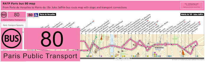
RATP Paris bus line 80 with stops, connections and street plan
However, the RATP Paris bus line 80 goes from Mairie du 18e - Jules Joffrin to Porte de Versailles, which is a way of getting to the Paris Expo Parc des Expositions events centre, but for the Eiffel Tower you would need the Ecole Militaire bus stop, then take a lovely walk through the Champ de Mars gardens to the security checkpoints.
Paris bus line 80 stops:
Porte de Versailles, Firmin Gillot**, Boulevard Victor*, Hameau*, Vaugirard - Croix Nivert**, Hopital de Vaugirard**, Duranton*, Convention - Lecourbe*, Convention - Vaugirard**, Abbe Groult, Vaugirard**, Mairie du 15e, Peclet**, Cambronne - Lecourbe*, Miollis*, Fondary**, Cambronne, La Motte-Picquet - Grenelle, General de Bollardiere, Ecole Militaire, Bosquet - Grenelle, Bosquet - Saint-Dominique, Bosquet - Rapp, Alma - Marceau, Montaigne - Francois 1er, Rond-Point des Champs-Elysees, Rd-Pt des Champs-Elysees - F. D. Roosevelt*, Rd-Pt des Champs-Elysees - Matignon**, Saint-Philippe du Roule*, Matignon - Saint-Honore**, Haussmann - Miromesnil**, La Boetie - Miromesnil*, Saint-Augustin, Pasquier - Anjou*, Gare Saint-Lazare - Rome, Europe, Bucarest, Place de Clichy, Place de Clichy - Caulaincourt*, Clichy - Caulaincourt**, Damremont - Caulaincourt, Square Caulaincourt, Lamarck - Caulaincourt, Custine - Mont-Cenis, Custine - Ramey*, Marcadet*, Mairie du 18e - Jules Joffrin.
* Stop served in direction of Porte de Versailles. ** Stop served in direction of Mairie du 18e - Jules Joffrin.
Paris bus line 80 main transport connections:
Metro Lines: 1, 2, 3, 6, 8, 9, 10, 12, 13, 14. Train Lines: C, E, J, L. Tram Lines: T2, T3a.
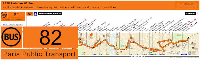
RATP Paris bus line 82 with stops, connections and street plan
Yet this shows the timetables and street maps for bus line 82 that travels from Neuilly - Hopital Americain through to Luxembourg, and with numerous bus stops on route, you will see that there are different stops you could get off the bus for the Eiffel Tower, which are the Champ de Mars - Suffren, Champ de Mars and the closest being the Tour Eiffel bus stop.
Paris bus line 82 stops:
Neuilly - Hopital Americain, Bineau - La Saussaye*, Bineau - Chateau**, Perronet, La Saussaye - D'Argenson*, Chateau, General Gouraud, Rue de l'Eglise**, Sainte-Foy, Eglise Saint-Pierre, Chartres, Montrosier - Parmentier, Andre Maurois**, Palais des Congres**, Porte Maillot - Pershing*, Porte Maillot, Alphand, Foch, Victor Hugo - Poincare, Lauriston*, Kleber - Boissiere, Lubeck, Iena, Varsovie, Tour Eiffel, Champ de Mars, Champ de Mars - Suffren, General Detrie, General de Bollardiere, Ecole Militaire, Vauban - Hotel des Invalides, Saint-Francois-Xabier, Oudinot, Duroc, Maine - Vaugirard, Montparnasse - Alencon, Montparnasse**, Montparnasse - Cinemas*, Notre-Dame des Champs**, Vavin, Brea - Notre-Dame des Champs*, Assas - Duguay-Trouin**, Guynemer - Vavin, Campagne - Port Royal, Observatoire - Port Royal, Val de Grace, Auguste Comte, Luxembourg.
* Stop served in direction of Neuilly - Hopital Americain. ** Stop served in direction of Luxembourg.
Paris bus line 82 main transport connections:
Metro Lines: 1, 2, 4, 6, 8, 9, 10, 12, 13. Train Lines: B, C, N.
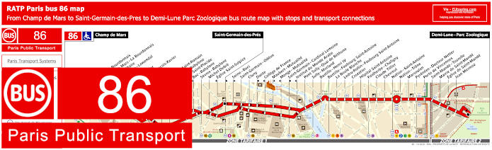
RATP Paris bus line 86 with stops, connections and street plan
However, this shows the RATP bus line 86 that travels from Demi-Lune - Parc Zoologique to Champ de Mars, where you will find the terminus point within very easy walking distance along the famous gardens, and on the opposite side you also have the Rapp - La Bourdonnais bus stop, yet as you can see from the street maps and timetables, please be aware that there are several stops only served in a particular direction.
Paris bus line 86 stops:
Champ de Mars, Rapp - La Bourdonnais, Champ de Mars - La Bourdonnais, Ecole Militaire, Duquesne - Lowendal, Breteuil*, El Salvador**, Saint-Francois-Xavier, Oudinot**, Duroc**, Vaneau - Saint-Romain**, Vaneau - Babylone*, Bac - Saint-Placide**, Bac - Babylone*, Sevres - Babylone, Michel Debre, Eglise Saint-Sulpice*, Saint-Germain-des-Pres**, Seine - Buci**, Saint-Germain - Odeon, Cluny, Dante**, College de France*, Maubert - Mutualite**, Monge - Mutualite*, Saint-Germain - Cardinal Lemoine**, Institut du Monde Arabe*, Pont Sully - Quai de Bethune, Sully - Morland, Bastille - Henri IV, Bastille - Faubourg Saint-Antoine, La Boule Blanche, Ledru-Rollin - Faubourg Saint-Antoine, Crozatier, Hopital Saint-Antoine, Faidherbe - Chaligny, Claude Tillier, Chevreul, Nation - Saint-Antoine, Nation - Trone, Marsoulan, Pyrenees - Docteur Netter, Porte de Vincennes, Saint-Mande - Tourelle, Mairie de Saint-Mande, Eglise de Saint-Mande, Jean Mermoz, Demi-Lune - Parc Zoologique.
* Stop served in direction of Champ de Mars. ** Stop served in direction of Demi-Lune - Parc Zoologique.
Paris bus line 86 main transport connections:
Metro Lines: 1, 2, 4, 5, 6, 7, 8, 9, 10, 12, 13. Train Line: A. Tram Lines: T3a, T3b.
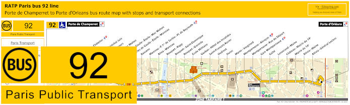
RATP Paris bus line 92 with stops, connections and street plan
Whereas the RATP bus line 92 travels from Porte d'Orleans to Porte de Champerret and has many bus stops for tourist attractions and transport hubs like you can see on the maps showing the Arc de Triomphe and the Ecole Militaire and it is this bus stop you would need to get to the Eiffel Tower security checkpoints by walking through the Champ de Mars gardens that were once the drill training grounds of the Ecole Militaire.
Paris bus line 92 stops:
Porte de Champerret, Pereire - Le Chatelier*, Pereire*, Pereire - Marechal Juin, Pierre Demours, Ternes - Mac Mahon, Charles de Gaulle - Etoile - Mac Mahon, Charles de Gaulle - Etoile - Marceau, Bassano, Marceau - P. 1er de Serbie - Pl. de Beyrouth, Alma - Marceau, Bosquet - Rapp, Bosquet - Saint-Dominique, Bosquet - Grenelle, Ecole Militaire, Vauban - Hotel des Invalides, Saint-Francois-Xavier, Oudinot, Duroc, Maine - Vaugirard, Montparnasse - Alencon, Montparnasse - Rue du Depart, Gare Montparnasse, Gaite, Losserand - Maine, Chateau - Mairie du 14e, Mairie du 14e, Alesia - Maine, Alesia - General Leclerc, Porte d'Orleans.
* A direction dependant stop.
Paris bus line 92 main transport connections:
Metro Lines: 1, 2, 3, 4, 6, 8, 9, 10, 12, 13. Train Lines: A, C, N. Tram Line: T3a.
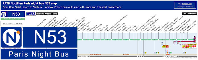
Paris Noctilien night bus N53 map with stops and transport connections
The Noctilien night buses take over from the daytime Paris buses between the hours of approximately midnight and 6am, and here you can see the maps and timetables for Noctilien N53, which travels from Paris Gare Saint-Lazare to Nanterre - Anatole France in the Paris region, and this particular night bus has a stop at Trocadero, which is ideal if you have been watching the Eiffel Tower lights and illuminations from the elevated viewpoint on the esplanade by the Palais de Chaillot.
Paris night bus line N53 stops:
Nanterre - Anatole France, Nanterre - Universite RER, Soufflot, Prefecture des Hauts-de-Seine, Nanterre - Prefecture RER, Esplanade Charles de Gaulle, Prefecture des Hauts-de-Seine, Joliot-Curie - Courbevoie, Palais des Sports, Mairie de Nanterre, Sadi Carnot - Joliot-Curie, Place de la Boule - Joliot-Curie, Place de la Boule - Joffre, Sainte-Genevieve, Boulevard National, Gabriel Peri, Le Gue, Hopital Stell, Place Richelieu, Zurich, Place Besche, Dunant, Lieutenant-Colonel de Montbrison, Place de la Paix, Place Jean Jaures, Croix du Roy, Val d’Or, Garibaldi, Longchamp, De Gaulle, Rue des Bourets - Pont de Suresnes, Les Moulins - Camping, La Muette - Boulainvilliers, Place Possoz, Scheffer, Trocadero, Kleber - Paul Valery, Charles de Gaulle - Etoile - Kleber, Charles de Gaulle - Etoile - Friedland, Balzac, Haussmann - Miromesnil, Saint-Augustin, Saint-Augustin - La Boetie, Pasquier - Anjou, Gare Saint-Lazare.
Paris night bus line N53 main transport connections: Metro Lines: 1, 2, 3, 6, 9, 12, 13, 14. Train Lines: A, E, J, L. Bus lines: N01, N02, N11, N15, N16, N24, N51, N52, N150, N151, N152, N153, N154.
Paris Open Tour bus sightseeing tour map for Blue, Red and Green bus lines with stops and timetables
Open Tour is one of the hop on and hop off tour buses in Paris that operates with three different routes you can utilise that cover much of the city and its famous tourist attractions, and as you can tell from the maps and information, to reach the Eiffel Tower you would need to be on the blue line and alight at the bus stop 14 called Tour Eiffel located at 69 Quai Branly, which is between the Avenue de Suffren and Allee Leon Bourgeois.
1: Haussman - Opera - Visitor centre - 13 Rue Auber, 75009 2: Opera - 4 Septembre - 49 Avenue de l'Opera, 75002 3: Palais-Royal - Comedie Francaise - 3 Avenue de l'Opera, 75002 4: Musee du Louvre - Place du Carrousel, 75001 5: Pont Neuf - Quai des Orfevres - Face au 64 Quai des Orfevres, 75001 6: Notre-Dame - Visitor Centre - 4 Rue du Petit Pont, 75005 7: Musee d'Orsay - 8 Quai Anatole France, 75007 8: Concorde - 12 Place de la Concorde, 75008 9: Champs-Elysees - Grand Palais - 14 Avenue des Champs-Elysees, 75008 10: Champs-Elysees - Disney Store - 60 Avenue des Champs-Elysees, 75008 11: Champs-Elysees - George V - 116 Avenue des Champs-Elysees, 75008 12: Champs-Elysees - Open Tour Kiosque - 125 Avenue des Champs-Elysees, 75008 13: Trocadero - Avenue du President Wilson, 75016 14: Tour Eiffel - 69 Quai Branly, 75007 15: Pont de l'Alma - 87 Quai Branly, 75007 16: Pont Alexandre III - Invalides - 41 Quai d'Orsay, 75007 17: Concorde-Royale - 4 Rue Royale, 75008 18: Madeleine - 18 Place de la Madeleine, 75008
Paris Open Tour bus sightseeing tour maps with stops and timetables:
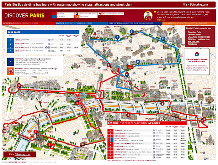
Big Bus Paris sightseeing tour map for Red and Blue bus lines with stops and timetables
Big Bus Paris is another hop on and hop off sightseeing tour bus operator and as you can see from the routes maps and information this has a bus stop 1 called the Tour Eiffel stop on the Quai Branly by Entree 2 Tour Eiffel. In addition, there is bus stop 2 called the Champ e Mars that stops on the Avenue Joseph Bouvard by the fountain at Place Jacques Rueff in the historical gardens.
1: Tour Eiffel - Quai Branly, Entree 2 Tour Eiffel 2: Champ de Mars - Avenue Joseph Bouvard 3: Opera Garnier - Facing 15 Rue Scribe (next to the RoissyBus airport shuttle bus stop) 4: Louvre - Pyramide / Big Bus Information Centre - 11 Avenue de l’Opera (by Big Bus information center) 5: Louvre - Pont des Arts - Quai Francois Mitterrand (near Pont des Arts) 6: Notre Dame - 3 Rue Lagrange (outside souvenir shop, opposite Square Rene Viviani) 7: Musee d'Orsay - 58 Place Henry de Montherlant (facing the museum by Quai Anatole France) 8: Champs-Elysees - 156 Avenue des Champs-Elysees (facing the Arc de Triomphe by Rue de Tilsitt) 9: Grand Palais - Avenue Winston Churchill (facing the Grand Palais and Petit Palais) 10: Trocadero - Avenue Paul Doumer (next to the Palais de Chaillot close to the Statue of Benjamin Franklin)
Big Bus Paris daytime sightseeing tour maps with stops and timetables:
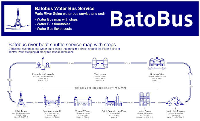
Paris Batobus map with river stops, timetables and ticket prices
The Batobus is a water bus service that operates as a hop on and hop off service on the River Seine, with stops at strategic locations along the banks of the river for you to get to various tourist attractions, and as you can see from the maps and information, you will find that the main Batobus stop is called the Eiffel Tower stop located on the Porte de la Bourdonnais to the right of the Eiffel Tower as you go down to the quay.
Batobus River Seine stops with attractions: Eiffel Tower - Port de la Bourdonnais, Pont Alexandre III - Port des Invalides, Musee D'Orsay - Quai de Solferino, Saint Germain des Pres - Quai Malaquais, Notre Dame - Quai de Montebello, Jardin des Plantes - Quai Saint-Bernard, Hotel de Ville - Quai de l'Hotel de Ville, The Louvre - Quai du Louvre, Place de la Concorde - Port des Champs-Elysees.
Batobus main transport connections:
Metro lines 1, 4, 6, 7, 8, 9, 10, 11, 12 and 13 RER B and C
Batobus ticket prices:
Adult One Day Pass €17.00 Adult Two Day Pass €19.00 Child One Day Pass (aged 3-15 years) €8.00 Child Two Day Pass (aged 3-15 years) €10.00 Child (aged -3 years) FREE
Batobus water bus maps, timetables and ticket prices available:
Le Bus Direct 1 Orly Airport to Place de Charles de Gaulle map with stops, timetables and ticket information
Here you can see the maps, timetables and ticketing information for Le Bus Direct 1, which is a dedicated shuttle bus service from Paris to Orly Airport, and as you can tell, the Trocadero stop at 10 Place du Trocadero by the Georges Mandel - Trocadero bus stop is close to the Eiffel Tower, meaning this is a very convenient way of getting to and from this Paris airport.
Le Bus Direct 1 stops:
Orly 4 (south terminal), Orly 1 2 3 (west terminal), Porte d'Orleans, Gare Montparnasse, Trocadero, Place Charles de Gaulle.
Le Bus Direct 1 ticket pricing:
Adult ticket €12.00 one way or €20.00 return Child ticket (aged 4-11 years) €7.00 one way or €14.00 return Group (discount for +3 people) €9.00 pp one way or €18.00 pp return pricing is per person
Download Le Bus Direct 1 route map, timetables and ticket info:
Le Bus Direct 2 Charles de Gaulle Airport to Eiffel Tower map with stops, timetables and ticket information
Yet this shows Le Bus Direct 2 with its route map, timetables and additional information including ticketing for the dedicated shuttle bus from Paris to Charles de Gaulle Airport, and a convenient hassle free option of Paris airport transport, you will see that this has a bus stop called Eiffel Tower, which is located at 19 Avenue de Suffren, just past Avenue Octave Greard and Rue Jean Rey close to the Champ de Mars and a short walk to the Eiffel Tower itself.
Le Bus Direct 2 stops:
CDG Airport Terminal 2E 2F, CDG Airport Terminal 2A 2C 2D, CDG Airport Terminal 1, Porte Maillot, Place de Charles de Gaulle, Eiffel Tower.
Le Bus Direct 2 ticket pricing 2020:
Adult ticket €18.00 one way or €31.00 return Child ticket (aged 4-11 years) €10.00 one way or €20.00 return Group (discount for +3 people) €13.00 pp one way or €26.00 pp return pricing is per person
Download Le Bus Direct 2 route map, timetables and ticket info:
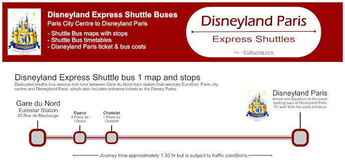
Disneyland Express shuttle bus service from the Eiffel Tower or Gare du Nord in Paris to Disneyland Paris theme parks
For those of you who are on holiday in Paris, yet would like a day trip to Disneyland Paris, then this is no problem with Disneyland Express shuttle service, with the Express Shuttle 2 departing from Rue Jean Rey, right by the Eiffel Tower, and as you can see from the pricing and information, entry tickets to the theme parks are included in the cost.
Disneyland Express shuttle bus 2 stops:
Eiffel Tower, Disneyland Paris.
Disneyland Express shuttle bus and amusement park ticket costs:
Adults (12+ years) Bus + 1 day ticket for 1 Disneyland Park €80.91 Adults (12+ years) Bus + 1 day ticket for 2 Disneyland Parks €98.50 Child (3-11 years) Bus + 1 day ticket for 1 Disneyland Park €74.75 Child (3-11 years) Bus + 1 day ticket for 2 Disneyland Parks €92.34 Child (0 - 2 years) FREE
Disneyland Express shuttle bus timetables, costs and maps available:
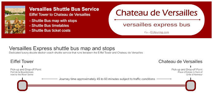
Versailles Express buses map with stops, timetables and ticket prices
However, if like the idea of a day trip to Chateau de Versailles, and discover the famous former royal palace, its grounds, even the coach museum, Trianon and Marie Antoinette's estate, then you are in luck with Versailles Express shuttle service that goes from the Port de la Bourdonnais by the River Seine at the foot of the Eiffel Tower. So if you look at the map and booking information, there are various options you can choose, whether it be just a shuttle bus transfer, or a full package including entry, the choice is yours.
Versailles Express bus pick up points:
Eiffel Tower Port de la Bourdonnais next to the River Seine. Chateau de Versailles Place d'Armes in front of Grille d’Honneur.
Versailles Express bus ticket prices:
Adult Half Day €29.00 Standard return and entrance to grounds. Adult Half Day €42.00 Standard return and entrance to grounds + Entrance to Palace Versailles with audio guide. Adult Full Day €52.00 Standard return and entrance to grounds + Entrance to Palace Versailles with audio guide + Entrance to gardens, even on days of Fountains Shows and Musical Gardens + Mini-train admission + Entrance to Palaces of Trianon and the Estate of Marie-Antoinette. Childen aged 0-9 years FREE Each child must be accompanied by an adult with paid admission.
Buying Versailles Express bus tickets:
You must purchase your Versailles Express bus ticket prior to trip, which can be ordered online at their website - Versailles Express.
Download Versailles Express bus maps with timetables and ticket prices:
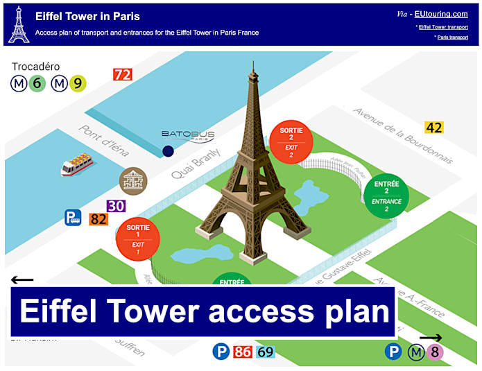
Access plan of transport and entrances for the Eiffel Tower
Whereas here we have a plan showing the most convenient bus routes and Metro stations along with the access plan for how to get into the grounds of the Eiffel Tower with the two beautiful gardens either side. Entrance 1 and 2 are the security checkpoints by the Champ de Mars before you can reach the ticket booths at the feet of the Eiffel Tower along with gaining access to the lifts etc in order to experience the historical monument itself, plus the two exits from the grounds are also shown closest to the River Seine.