How to get to Arc de Triomphe in Paris using public transport
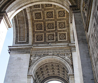
The Arc de Triomphe is the famous monumental triumphal arch commissioned by Napoleon Bonaparte located on the axis that goes through to the Louvre Museum, and here you can enjoy panoramic views from the top, discover the Tomb of the Unknown Soldier and the Eternal Flame. Therefore, below you can see how to get to the Arc de Triomphe with maps, timetables and visitor plans that can be downloaded in PDF or image formats for you PC or mobile device.
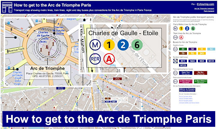
Arc de Triomphe transport map of Metro lines, trains and bus lines with stops, connections and street plan
Here we have a street map showing the location of train and Metro stations along with bus stops for all the different Paris buses that converge the area around the Arc de Triomphe, which includes daytime and Noctilien night buses, tour companies and dedicated shuttle buses that will get you to and from the Paris Airports of Orly and CDG.
How to get to Arc de Triomphe public transport maps available:
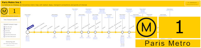
Paris Metro Line 1 map with stations, connections and points of interest
These maps show the Metro line 1, which travels from the business district of La Defense by the Grande Arche and is great for getting to Chateau de Vincennes, which is the terminus by the medieval Paris castle, and one of the stops on route is called the Charles de Gaulle Etoile Metro station located underneath the Arc de Triomphe.
In fact, the Metro station used to be called just Etoile, being a star, representing the wide avenues that converge on this intersection, which is one of the largest and most notorious in the world, yet it was in 1970 that the Metro station and the square were renamed Charles de Gaulle - Etoile, named after the French General, leader of the Free French Forces and French President during World War II.
Metro Line 1 stops:
La Defense, Esplanade de La Defense, Pont de Neuilly, Les Sablons, Porte Maillot, Argentine, Charles de Gaulle Etoile, George V, Franklin D Roosevelt, Champs-Elysees - Clemenceau, Concorde, Tuileries, Palais Royal - Musee du Louvre, Louvre - Rivoli, Chatelet, Hotel de Ville, Saint-Paul, Bastille, Gare de Lyon, Reuilly - Diderot, Nation, Porte de Vincennes, Saint-Mande, Berault, Chateau de Vincennes.
Metro line 1 main transport connections:
Metro Lines: 2, 4, 5, 6, 7, 8, 9, 11, 12, 13, 14. Train Lines: A, B, C, D, L, R, U. Tram Lines: T2, T3a, T3b.
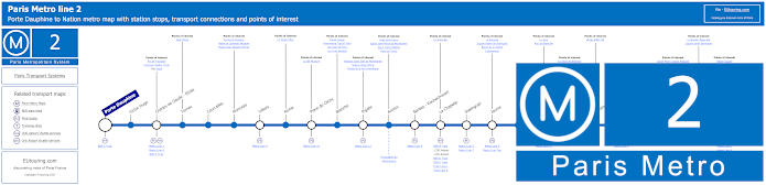
Paris Metro Line 2 map with stations, connections and points of interest
Although, the Metro Line 2 goes from Porte Dauphine through to Nation with many Metro stops on route that have transport connections including the Charles de Gaulle - Etoile Metro station located under the Arc de Triomphe, which was the triumphal arch commissioned by Napoleon Bonaparte after his victory at the Battle of Austerlitz.
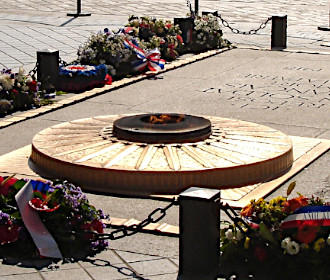
As a point of interest, you will also get to see the Tomb of the Unknown Soldier in memory of those that lost their lives during World War I and the Eternal Flame, which is rekindled in a ceremony every evening at 6:30pm, and also re-lit symbolically in a ceremony with each newly elected president.
Metro Line 2 stops:
Porte Dauphine, Victor Hugo, Charles de Gaulle - Etoile, Ternes, Courcelles, Monceau, Villiers, Rome, Place de Clichy, Blanche, Pigalle, Anvers, Barbes - Rochechouart, La Chapelle, Stalingrad, Jaures, Colonel Fabien, Belleville, Couronnes, Menilmontant, Pere Lachaise, Philippe Auguste, Alexandre Dumas, Avron, Nation.
Metro line 2 main transport connections:
Metro Lines: 1, 3, 4, 5, 6, 7, 7bis, 9, 11, 12, 13. Train Lines: A, B, C, D, E, H, K, Funiculaire du Montmartre.
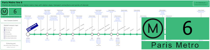
Paris Metro Line 6 map with stations, connections and points of interest
Whereas the Metro Line 6 goes between the transport hub of Nation and Charles de Gaulle - Etoile, which is the Metro station at the Arc de Triomphe we have already mentioned, but this Paris Metro line is also how to get to the Eiffel Tower and many other tourist attractions.
But getting back to the Arc de Triomphe, you may be pleased to know that there is a museum located inside along with telescopes on the viewing platform, which is also now accessible to the disabled with a lift having been installed rather than negotiating numerous steps.
Metro line 6 stops:
Charles de Gaulle - Etoile, Kleber, Boissiere, Trocadero, Passy, Bir-Hakeim, Dupleix, La Motte-Picquet - Grenelle, Cambronne, Sevres - Lecourbe, Pasteur, Montparnasse - Bienvenue, Edgar Quinet, Raspail, Denfert-Rochereau, Saint-Jacques, Glaciere, Corvisart, Place d'Italie, Nationale, Chevaleret, Quai de la Gare, Bercy, Dugommier, Daumesnil, Bel-Air, Picpus, Nation.
Metro line 6 main transport connections:
Metro Lines: 1, 2, 4, 5, 7, 8, 9, 10, 12, 13, 14. Train Lines: A, B, C, N. Bus Line: OrlyBus.
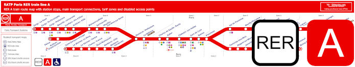
Red RER A train line map showing station stops, line branches, transport connections and zones
Here you can see the RER A train line that travels from central Paris at places like Paris Gare de Lyon, Chatelet Les Halles and Auber, in addition to the Charles de Gaulle Etoile train station, and the RER A line goes to the outskirts of the Paris region including being a way of getting to Disneyland Paris.
Paris RER A train line stops:
Cergy le Haut*, Cergy Saint-Christophe, Cergy Prefecture, Neuville Universite, Conflans Fin d’Oise, Acheres Ville, Maisons-Laffitte, Sartrouville, Houilles - Carrieres sur Seine, Nanterre Prefecture, La Defense (Grande Arche), Charles de Gaulle Etoile, Auber, Chatelet Les Halles, Paris Gare de Lyon, Nation, Vincennes, Val de Fontenay, Neuilly Plaisance, Bry sur Marne, Noisy le Grand - Mont d’Est, Noisy Champs, Noisiel, Lognes, Torcy, Bussy Saint-Georges, Val d’Europe, Marne la Vallee - Chessy (Parcs Disneyland)*, Poissy*, Acheres - Grand Cormier, Saint-Germain en Laye*, Le Vesinet Le Pecq, Le Vesinet Centre, Chatou Croissy, Rueil Malmaison, Nanterre Ville, Nanterre University, Fontenay sous Bois, Nogent sur Marne, Joinville le Pont, Saint-Maur - Creteil, Le Parc de Saint-Maur, Champigny, La Varenne - Chennevieres, Sucy Bonneuil, Boissy Saint-Leger*.
* Terminus Points.
Paris RER A train line main transport connections:
Metro Lines: 1, 2, 3, 4, 6, 7, 8, 9, 11, 14. Train Lines: B, D, E, J, L, R, U, TGV. Tram Lines: T2, 13. Bus Lines: 393, RoissyBus, TVM (14).
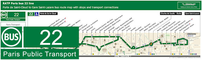
RATP Paris bus line 22 with stops, connections and street plan
You will find that the Paris bus line 22 travels from Porte de Saint-Cloud through to Gare Saint-Lazare train station, although as you can tell from the bus maps and timetables, sometimes it only travels through to Charles de Gaulle Etoile where there is a bus stop on the Avenue Hoche for getting to the Arc de Triomphe.
Paris bus line 22 stops:
Porte de Saint-Cloud, Porte de Saint-Cloud - Murat, Versailles - Chardon-Lagache, Versailles - Exelmans**, Jouvenet*, Victorien Sardou**, Chardon-Lagache - Molitor*, Wilhem**, Pont Mirabeau**, Eglise d’Auteuil, George Sand - La Fontaine**, Perrichont*, Jasmin**, Theophile Gautier - Rue Gros*, Place du Docteur Hayem - Radio France*, Assomption - Radio France*, Ranelagh**, Les Vignes - Boulainvilliers RER*, La Muette - Boulainvilliers, Place Possoz, La Tour, Scheffer, Trocadero, Kleber - Boissiere, Kleber - Paul Valery, Charles de Gaulle - Etoile - Kleber, Charles de Gaulle - Etoile, Hoche - Saint-Honore, Friedland - Haussmann, Haussmann - Courcelles, Haussmann - Miromesnil, Saint-Augustin - La Boetie*, Saint-Augustin, Pasquier - Anjou*, Gare Saint-Lazare.
* Stop served in direction of Porte de Saint-Cloud. ** Stop served in direction of Gare Saint-Lazare.
Paris bus line 22 main transport connections:
Metro Lines: 1, 2, 3, 6, 9, 10, 12, 13, 14. Train Lines: A, C, E, J, L.
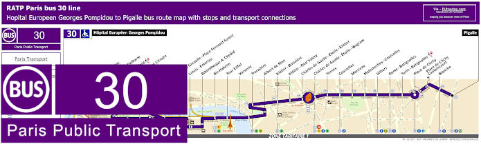
RATP Paris bus line 30 with stops, connections and route plan
Yet these maps and timetables show the RATP Paris bus line 30 travelling from Hopital Europeen Georges Pompidou to Pigalle in the Montmartre area, and as you can see at the Arc de Triomphe there is the bus stop Charles de Gaulle - Etoile - Kleber or the Charles de Gaulle - Etoile - Wagram on the opposite side of the intersection, both of which will get you to this historical triumphal arch.
Paris bus line 30 stops:
Hopital Europeen Georges Pompidou, Rue Leblanc, Leblanc - Delbarre*, Place Balard, Parc Andre Citroen, Cauchy, Javel, Pont de Grenelle-Place Fernand Forest, Linois - Emeriau, Bibliotheque A. Chedid*, Bir-Hakeim, Tour Eiffel, Varsovie, Trocadero, Albert de Mun, Kleber - Boissiere, Kleber - Paul Valery, Charles de Gaulle - Etoile - Kleber, Charles de Gaulle - Etoile - Wagram, Ternes, Courcelles, Monceau, Malesherbes - Courcelles, Villiers, Rome - Batignolles, Turin - Batignolles, Place de Clichy, Place de Clichy - Caulincourt**, Blanche, Pigalle.
* Served in direction of Pigale. ** Served in direction of Hopital Europeen Georges Pompidou.
Paris bus line 30 main transport connections:
Metro Lines: 1, 2, 3, 6, 8, 9, 10, 12, 13. Train Lines: A, C. Tram Line: T3a.
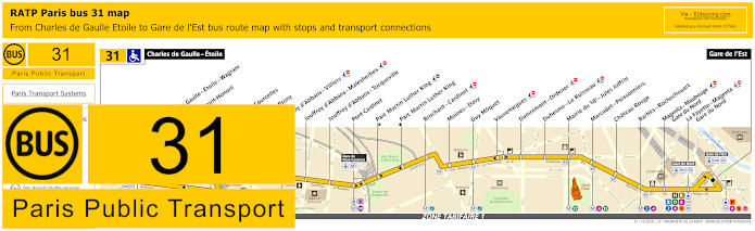
RATP Paris bus line 31 with stops, connections and street plan
Although the Paris bus line 31 travels from Gare de l'Est train station through to Charles de Gaulle - Etoile, and just like the bus route above, this is the bus stop you would need in order to access the Arc de Triomphe with the museum detailing its rich history along with the impressive views from the top of the landmark.
Paris bus line 31 stops:
Charles de Gaulle - Etoile, Charles de Gaulle - Etoile - Wagram**, Hoche - Saint-Honore*, Ternes, Wagram - Courcelles, Wagram - Prony, Jouffroy d'Abbans - Villiers, Jouffroy d'Abbans - Malesherbes, Jouffroy d'Abbans - Tocqueville, Pont Cardinet, Parc Martin Luther King**, Parc Martin Luther King*, Brochant - Cardinet, Moines - Davy, Guy Moquet, Vauvenargues, Damremont - Ordener, Duhesme - Le Ruisseau, Mairie du 18e - Jules Joffrin, Marcadet - Poissonniers, Chateau Rouge, Barbes - Rochechouart, Magenta - Maubeuge - Gare du Nord, La Fayette - Magenta - Gare du Nord, Gare de l'Est.
* Served in direction of Charles de Gaulle - Etoile. ** Served in direction of Gare de l'Est.
Paris bus line 31 main transport connections:
Metro Lines: 1, 2, 3, 4, 5, 6, 7, 12, 13, 14. Train Lines: A, B, D, E, H, K, L, P.
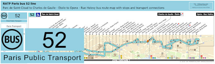
RATP Paris bus line 52 with stops, connections and route plan
Whereas here you have the bus line 52 run by RATP that travels between Parc de Saint-Cloud and Opera - Rue Halevy, but as you can see from the maps and timetables there are some stops only served in a particular direction and only a partial service at certain times going to Charles de Gaulle - Etoile, which is in fact the stop you would need for the Arc de Triomphe on the Avenue Hoche.
Paris bus line 52 stops:
Parc de Saint-Cloud, La Colline**, Pont de Saint-Cloud - Rive Gauche**, Pont de Saint-Cloud - Albert Kahn, Rhin et Danube - Metro, Rue de Silly, Rue de Billancourt, Jean Jaures, Rue de l’Est, Denfert-Rochereau, La Tourelle, Porte Molitor, Porte d’Auteuil***, Gare d’Auteuil, Michel-Ange - Auteuil, Mozart - La Fontaine*, Eglise d’Auteuil**, George Sand - La Fontaine*, Perrichont**, Leopold II*, La Fontaine - Radio France**, Rodin**, Ranelagh**, Assomption - Radio France*, Les Vignes - Boulainvilliers*, La Muette - Boulainvilliers, Nicolo - Jean Richepin, Pompe - Mairie du 16e, Lycee Janson de Sailly, Place Jean Monnet, Bugeaud, Victor Hugo - Poincare, Victor Hugo - Paul Valery, Charles de Gaulle - Etoile - Victor Hugo, Charles de Gaulle - Etoile - Friedland***, Hoche - Saint-Honore, Friedland - Haussmann, Haussmann - Courcelles, Saint-Philippe du Roule, La Boetie - Percier*, Matignon - Saint-Honore**, Haussmann - Miromesnil**, Saint-Augustin - La Boetie*, Saint-Augustin**, Anjou - Chaveau Lagarde, Madeleine - Malesherbes*, Madeleine, Capucines - Caumartin, Opera - Rue de la Paix**, Opera - Rue Halevy.
* Stop served in direction of Parc de Saint-Cloud. ** Stop served in direction of Opera - Rue Halevy. *** Only a partial service operates in the evening between Porte d'Auteuil and Charles de Gaulle Etoile - Friedland.
Paris bus line 52 main transport connections:
Metro Lines: 1, 2, 3, 6, 7, 8, 9, 10, 12, 13, 14. Train Lines: A, C. Tram Line: T2.
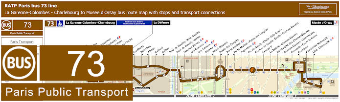
RATP Paris bus line 73 with stops, connections and street plan
Here you have the RATP bus line 73 maps and timetables showing the route travelling from Musee d'Orsay to La Garenne-Colombes - Charlebourg on a Monday to Saturday except for French National holidays, yet on a Sunday and holidays the terminus is La Defense, which is how to get to the Grande Arche, but for the Arc de Triomphe you would need the bus stop on the Avenue de la Grande Armee of the Avenue des Champs-Elysees bus stop on the opposite side of the star intersection.
Paris bus line 73 stops:
La Garenne-Colombes - Charlebourg***, Nordmann***, Les Fauvelles***, Puvis de Chavannes***, Rue des Etudiants***, Leonardo de Vinci***, Faubourg de l’Arche** ***, Caron***, La Defense, Gambetta*, Boieldieu**, Alsace*, Gallieni**, Bellini**, Pont de Neuilly - Rive Gauche, Pont de Neuilly, Les Graviers, Rue de l’Hotel de Ville, Les Sablons, Marche, Montrosier*, Andre Maurois**, Palais des Congres**, Porte Maillot**, Porte Maillot - Palais des Congres*, Argentine, Charles de Gaulle - Etoile - Gde Armee, Charles de Gaulle - Etoile - Champs-Elysees, George V, La Boetie - Champs-Elysees, Rond-Point des Champs-Elysees, Champs-Elysees - Clemenceau, Concorde - Cours la Reine, Concorde*, Assemblee Nationale, Lille - Universite**, Musee d'Orsay.
* Stop served in direction of La Garenne-Colombes - Charlebourg or La Defense. ** Stop served in direction of Musee d'Orsay. *** Not served on a Sunday or French holidays.
Paris bus line 73 main transport connections:
Metro Lines: 1, 2, 6, 8, 9, 12, 13. Train Lines: A, C, L, U. Tram Line: T2.
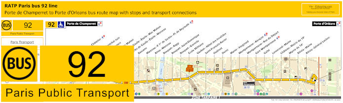
RATP Paris bus line 92 with stops, connections and street plan
However, the RATP Paris bus line 92 with its various transport connections on route, goes between Porte de Champerret and Porte d'Orleans, and as you can see from the maps and timetables, there are two bus stops either side of the Arc de Triomphe called the Charles de Gaulle - Etoile - Mac Mahon stop and the Charles de Gaulle - Etoile - Marceau bus stop, yet this is also an option for getting to Les Invalides utilising the Ecole Militaire stop along with other tourist attractions.
Paris bus line 92 stops:
Porte de Champerret, Pereire - Le Chatelier*, Pereire*, Pereire - Marechal Juin, Pierre Demours, Ternes - Mac Mahon, Charles de Gaulle - Etoile - Mac Mahon, Charles de Gaulle - Etoile - Marceau, Bassano, Marceau - P. 1er de Serbie - Pl. de Beyrouth, Alma - Marceau, Bosquet - Rapp, Bosquet - Saint-Dominique, Bosquet - Grenelle, Ecole Militaire, Vauban - Hotel des Invalides, Saint-Francois-Xavier, Oudinot, Duroc, Maine - Vaugirard, Montparnasse - Alencon, Montparnasse - Rue du Depart, Gare Montparnasse, Gaite, Losserand - Maine, Chateau - Mairie du 14e, Mairie du 14e, Alesia - Maine, Alesia - General Leclerc, Porte d'Orleans.
* A direction dependant stop.
Paris bus line 92 main transport connections:
Metro Lines: 1, 2, 3, 4, 6, 8, 9, 10, 12, 13. Train Lines: A, C, N. Tram Line: T3a.
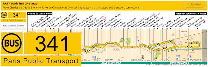
RATP Paris bus line 341 with stops, connections and street plan
Going from Porte de Clignancourt - Croisset the Paris bus line 341 travels to Charles de Gaulle - Etoile, which is the bus stop located on the Avenue Foche that you would need for getting to the Tomb of the Unknown Soldier and Eternal Flame, but please take note of the maps and timetables, as this bus route also travels into ticket tariff zone 2.
Paris bus line 341 stops:
Charles de Gaulle - Etoile, Charles de Gaulle Etoile - Mac Mahon, Ternes–Mac Mahon, Pierre Demours, Pereire - Marechal Juin, Pereire**, Pereire - Le Chatelier*, Gourgaud - Paul Adam*, Porte d’Asnieres Marguerite Long, Alsace, Gare de Clichy - Levallois, Chance - Milly, Jaures - Barbusse, Barbusse - Martre**, Landy - Martre, Bateliers**, Villeneuve - General Leclerc*, Hopital Beaujon, Claude Debussy, Rue Pierre, Cimetiere, Fondation Roguet, Citroen**, Georges Boisseau, Victor Hugo - Sanzillon, Clichy - Saint-Ouen RER, Camille Claudel, Touzet - Gaillard, Floreal**, Colisee*, Bois Le Pretre**, Epinettes - Pouchet**, Toulouse-Lautrec*, Porte de St-Ouen, Angelique Compoint, Porte de Clignancourt, Poissonniers - Cocteau**, Porte de Clignancourt - Croisset.
* Stop served in direction of Charles de Gaulle Etoile. ** Stop served in direction of Porte de Clignancourt Croisset.
Paris bus line 341 main transport connections:
Metro Lines: 1, 2, 3, 4, 6, 13, 14. Train Lines: A, C, L. Tram Line: T3b. Bus Lines: 20, 21, 22, 30, 31, 52, 54, 56, 66, 73, 74, 84, 85, 92, 93, 94, 98 (PC), 137, 138, 140, 163, 166, 173, 174, 244, 255, 274, 340, La Traverse (513), TUC Est (574), TUC Ouest (574).
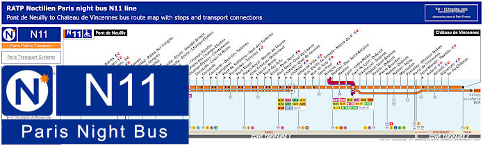
Paris Noctilien night bus N11 map with stops and transport connections
Noctilien is the Paris night bus service that operates from around 12:30am to 5:30am when other Paris transport has finished for the night, and here you can see the Noctilien N11 night bus line going from Pont de Neuilly to Chateau de Vincennes stopping at transport hubs such as Chatelet and Gare de Lyon - Diderot plus there are two stops either side of the Arc de Triomphe being the Charles de Gaulle - Etoile - Grande Armme and the Charles de Gaulle - Etoile - Champs-Elysees.
Paris night bus line N11 stops:
Pont de Neuilly, Maurice Barres, Les Graviers, Les Sablons, Marche, Andre Maurois*, Porte Maillot - Palais des Congres*, Palais des Congres**, Porte Maillot**, Argentine, Charles de Gaulle - Etoile - Grande Armee, Charles de Gaulle - Etoile - Champs-Elysees, George V, La Boetie - Champs-Elysees, Rond-Point des Champs-Elysees, Champs-Elysees - Clemenceau, Concorde - Cours la Reine, Concorde*, Concorde - Quai des Tuileries**, Castiglione*, Pont de Solferino - Quai des Tuileries**, Pyramides - Tuileries*, Pont Royal**, Palais Royal - Musee du Louvre*, Quai Francois Mitterrand**, Louvre - Rivoli*, Pont des Arts**, Rivoli - Pont Neuf*, Pont Neuf - Quai du Louvre**, Chatelet - Quai de Gesvres**, Chatelet*, Hotel de Ville, Rue Vieille du Temple - Mairie du 4e*, Rue de Jouy**, Saint-Paul, Birague, Bastille - Rue Saint-Antoine, Bastille, Lyon - Ledru-Rollin, Gare de Lyon - Diderot, Daumesnil - Diderot, Hopital Saint-Antoine, Reuilly - Diderot, Pierre Bourdan, Nation - Diderot, Nation - Trone, Marsoulan, Pyrenees - Docteur Netter, Porte de Vincennes, Saint-Mande - Tourelle**, Aubert, Berault, Vignerons, Avenue du Chateau, Chateau de Vincennes.
* In direction of Pont de Neuilly. ** In direction of Chateau de Vincennes.
Paris night bus line N11 main transport connections:
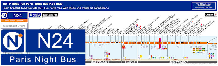
Paris Noctilien night bus N24 map with stops and transport connections
Whereas the Noctilien night bus line N24 travels between Sartrouville RER in tariff zone 4 and Chatelet in ticket tariff zone 1, which is one of the options for how to get to Palais des Congres and the Palais Royal - Musee du Louvre in addition to the Arc de Triomphe via the same night bus stops as for Noctililen line N11.
Paris night bus line N24 stops:
Satrouville RER, Poste, Stalingrad, Jean Mermoz, Voltaire, Edouard Vaillant, Eglise, Picardie, Charles de Gaulle, Quatre Chemins, Rue de Chatou, Clemenceau, Condorcet, Val Notre-Dame, La Berthie, Albert 1er, Place des Droits de l'Homme, La Grace de Dieu, Pont de Bezons, Parc Pierre Lagravere, Victor Basch, Jacqueline Auriol, Gare de La Garenne-Colombes, La Garenne-Colombes - Charlebourg, Nordmann, Les Fauvelles, Dieppe, Faubourg de l'Arche, Caron, La Defense, Boieldieu**, Gallieni**, Gambetta*, Bellini**, Alsace*, Pont de Neuilly - Rive Gauche, Pont de Neuilly - Metro, Maurice Barres, Les Graviers, Les Sablons, Marche, Andre Maurois*, Porte Maillot - Palais de Congres*, Palais de Congres**, Porte Maillot**, Argentine, Charles de Gaulle - Etoile - Grande Armee, Charles de Gaulle - Etoile - Champs-Elysees, George V, La Boetie - Champs-Elysees, Rond-Point des Champs-Elysees, Champs-Elysees - Clemenceau, Concorde - Cours la Reine, Concorde*, Concorde - Quai des Tuileries**, Castiglione*, Pont de Solferino - Quai des Tuileries**, Pyramides - Tuileries*, Pont Royal**, Palais Royal - Musee du Louvre*, Quai Francois Mitterrand**, Pont des Arts**, Louvre - Rivoli*, Rivoli - Pont Neuf*, Pont Neuf - Quai du Louvre**, Chatelet - Quai de Gesvres**, Chatelet.
* Stop served in direction of Sartrouville RER. ** Stop served in direction of Chatelet.
Paris night bus line N24 main transport connections:
Metro Lines: 1, 2, 4, 6, 7, 8, 9, 11, 12, 14. Train Lines: A, B, C, D, J, L, U. Tram Line: T2. Bus Lines: N01, N02, N11, N12, N13, N14, N15, N16, N21, N22, N23, N122, N153.
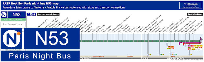
Paris Noctilien night bus N53 map with stops and transport connections
Yet here you have the Noctilien line N53 night bus that travels from Nanterre - Anatole France to Gare Saint-Lazare, and this is a way of getting to the Hippodrome de Longchamp horse racing course or the Bois de Boulogne, yet when it comes to reaching the Arc de Triomphe and the Tomb of the Unknown Soldier, you would need either the Charles de Gaulle - Etoile - Kleber or Charles de Gaulle - Etoile - Friedland night bus stops.
Paris night bus line N53 stops:
Nanterre - Anatole France, Nanterre - Universite RER, Soufflot, Prefecture des Hauts-de-Seine, Nanterre - Prefecture RER, Esplanade Charles de Gaulle, Prefecture des Hauts-de-Seine, Joliot-Curie - Courbevoie, Palais des Sports, Mairie de Nanterre, Sadi Carnot - Joliot-Curie, Place de la Boule - Joliot-Curie, Place de la Boule - Joffre, Sainte-Genevieve, Boulevard National, Gabriel Peri, Le Gue, Hopital Stell, Place Richelieu, Zurich, Place Besche, Dunant, Lieutenant-Colonel de Montbrison, Place de la Paix, Place Jean Jaures, Croix du Roy, Val d’Or, Garibaldi, Longchamp, De Gaulle, Rue des Bourets - Pont de Suresnes, Les Moulins - Camping, La Muette - Boulainvilliers, Place Possoz, Scheffer, Trocadero, Kleber - Paul Valery, Charles de Gaulle - Etoile - Kleber, Charles de Gaulle - Etoile - Friedland, Balzac, Haussmann - Miromesnil, Saint-Augustin, Saint-Augustin - La Boetie, Pasquier - Anjou, Gare Saint-Lazare.
Paris night bus line N53 main transport connections:
Metro Lines: 1, 2, 3, 6, 9, 12, 13, 14. Train Lines: A, E, J, L. Bus lines: N01, N02, N11, N15, N16, N24, N51, N52, N150, N151, N152, N153, N154.
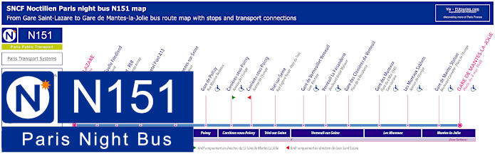
Paris Noctilien night bus N151 map with stops and transport connections
However, the Noctilien N151 night bus line has a stop called Charles de Gaulle - Frieldland on the Avenue de Friedland close to the star intersection that is home to the famous historical monument and this night bus line goes from Gare Saint-Lazare to Gare de Mantes la Jolie, stopping at many other train stations on route.
Paris night bus line N151 stops:
Gare St-Lazare - Cour de Rome, Charles de Gaulle - Friedland - Avenue de Friedland, Porte Maillot - RER - Avenue de la Grande Armee, Orgeval Novotel Pont A13*, Gare de Villennes-sur-Seine - Place de la Liberation, Gare de Poissy - Rue Maurice Berteaux, Carrieres-sous-Poissy - Avenue de l'Europe**, Triel-sur-Seine - Rue Eugene Senet - Pont du Triel, Gare de Vernouillet Verneuil - Gare Routiere, Verneuil La Faisanderie - Boulevard Andre Malraux, Gare des Clairieres de Verneuil - Place de la Resistance, Gare des Mureaux - Place du 8 Mai 1945 - Gare Routiere, Les Mureaux Sablons - Avenue de l'Europe, Gare de Mantes Station - Boulevard Calmette - Place de l'Europe, Gare de Mantes-La-Jolie - Place du 8 Mai 1945.
* Night bus served in direction of Gare de Mantes La Jolie. ** Night buses at this stop served in direction of Gare St-Lazare are not suitable for the disabled and wheelchair users.
Paris night bus line N151 main transport connections:
Metro Lines: 3, 9, 12, 13, 14. Train lines: E, J, L. Bus Lines: N01, N02, N11, N15, N16, N24, N51, N52, N53, N150, N152, N153, N154.
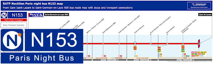
Paris Noctilien night bus N153 map with stops and transport connections
Although the Noctilien line N153 travels from Gare Saint-Lazare to Saint-Germain-en-Laye RER, and as you can see from the night bus maps and timetables with the various transport connections also shown, there is the Charles de Gaulle - Etoile - Friedland stop for getting from or to the Arc de Triomphe.
Paris night bus line N153 stops:
Saint-Germain-en-Laye RER*, Le Vesinet - Le Pecq RER, Hotel de Ville - Le Vesinet Centre RER, Mairie - Chatou - Croissy RER, Rueil-Malmaison RER, Jules Quentin - Nanterre - Ville RER, Pont de Neuilly*, Porte Maillot - Palais des Congres**, Porte Maillot**, Charles de Gaulle - Etoile - Friedland*, Gare Saint-Lazare*.
* Different start times depending upon your stop and what night of the week. ** Stop only served in a specific direction.
Paris night bus line N153 main transport connections:
Metro Lines: 1, 2, 3, 6, 9, 12, 13, 14. Train Lines: A, C, E, J, L. Tram Line: T13 Bus Lines: N01, N02, N11, N15, N16, N24, N51, N52, N53, N150, N151, N152, N154.
Paris Open Tour bus sightseeing tour map for Blue, Red and Green bus lines with stops and timetables
If you like the idea of a sightseeing bus tour for getting to see many of the tourist attractions around the city, there is the great option of Open Tour, which is a hop on and hop off sightseeing bus tour company. With numerous stops at strategic locations like Bastille, Musee du Louvre, obviously the Eiffel Tower and numerous others.
So, when it comes to getting to the Arc de Triomphe, you would need the Blue Line and stop 12 called the Champs-Elysees - Open Tour Kiosque stop located at 125 Avenue des Champs Elysees, 75008, which as you can see from the route map, is the stop after it has gone up the famous tree-lined avenue and around the Arc de Triomphe roundabout.
1: Haussman - Opera - Visitor centre - 13 Rue Auber, 75009 2: Opera - 4 Septembre - 49 Avenue de l'Opera, 75002 3: Palais-Royal - Comedie Francaise - 3 Avenue de l'Opera, 75002 4: Musee du Louvre - Place du Carrousel, 75001 5: Pont Neuf - Quai des Orfevres - Face au 64 Quai des Orfevres, 75001 6: Notre-Dame - Visitor Centre - 4 Rue du Petit Pont, 75005 7: Musee d'Orsay - 8 Quai Anatole France, 75007 8: Concorde - 12 Place de la Concorde, 75008 9: Champs-Elysees - Grand Palais - 14 Avenue des Champs-Elysees, 75008 10: Champs-Elysees - Disney Store - 60 Avenue des Champs-Elysees, 75008 11: Champs-Elysees - George V - 116 Avenue des Champs-Elysees, 75008 12: Champs-Elysees - Open Tour Kiosque - 125 Avenue des Champs-Elysees, 75008 13: Trocadero - Avenue du President Wilson, 75016 14: Tour Eiffel - 69 Quai Branly, 75007 15: Pont de l'Alma - 87 Quai Branly, 75007 16: Pont Alexandre III - Invalides - 41 Quai d'Orsay, 75007 17: Concorde-Royale - 4 Rue Royale, 75008 18: Madeleine - 18 Place de la Madeleine, 75008
Paris Open Tour bus sightseeing tour maps with stops and timetables:
Big Bus Paris sightseeing tour map for Red and Blue bus lines with stops and timetables
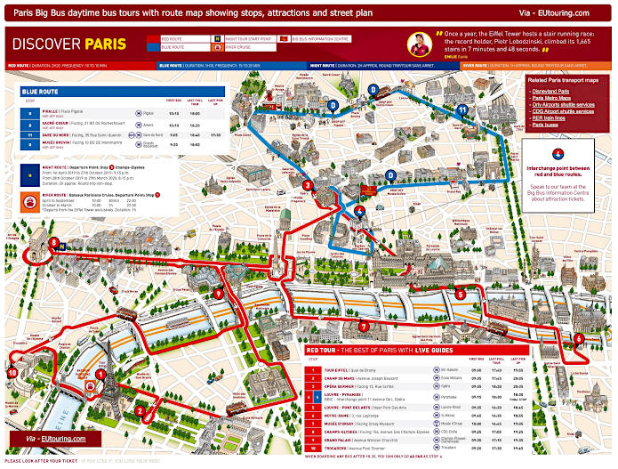
Additionally, you have the Big Bus Paris sightseeing tour company that also offers a hop on and hop off bus tour service, with the stop you would need being on the Red Route and stop 8, which is called the Champs-Elysees stop at 156 Avenue des Champs-Elysees that facing the Arc de Triomphe by Rue de Tilsitt.
1: Tour Eiffel - Quai Branly, Entree 2 Tour Eiffel 2: Champ de Mars - Avenue Joseph Bouvard 3: Opera Garnier - Facing 15 Rue Scribe (next to the RoissyBus airport shuttle bus stop) 4: Louvre - Pyramide / Big Bus Information Centre - 11 Avenue de l’Opera (by Big Bus information center) 5: Louvre - Pont des Arts - Quai Francois Mitterrand (near Pont des Arts) 6: Notre Dame - 3 Rue Lagrange (outside souvenir shop, opposite Square Rene Viviani) 7: Musee d'Orsay - 58 Place Henry de Montherlant (facing the museum by Quai Anatole France) 8: Champs-Elysees - 156 Avenue des Champs-Elysees (facing the Arc de Triomphe by Rue de Tilsitt) 9: Grand Palais - Avenue Winston Churchill (facing the Grand Palais and Petit Palais) 10: Trocadero - Avenue Paul Doumer (next to the Palais de Chaillot close to the Statue of Benjamin Franklin)
Big Bus Paris daytime sightseeing tour maps with stops and timetables:
Le Bus Direct 1 Orly Airport to Place de Charles de Gaulle map with stops, timetables and ticket information
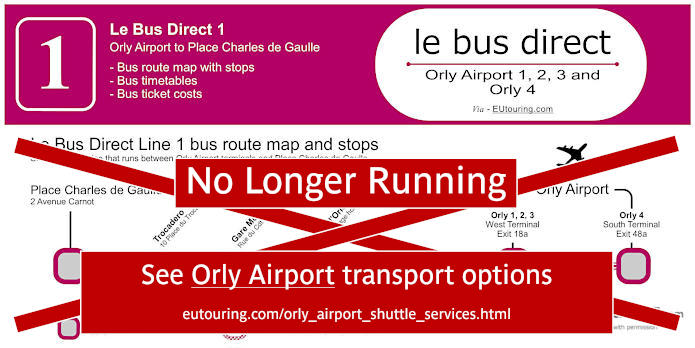
When it comes to getting to Orly Airport from the Arc de Triomphe, you will be pleased to know that there is a dedicated airport shuttle bus service with Le Bus Direct, which is Route 1 that goes to both terminals of Orly 1-2-3 and Orly 4, and Le Bus Direct 1 has a stop called Etoile / Champs Elysees at 2 Avenue Carnot, which is a road on the major intersection, and at Orly Airport the bus stop is on Level O Arrivals, Gate D, Platform 1.
Le Bus Direct 1 stops:
Orly 4 (south terminal), Orly 1 2 3 (west terminal), Porte d'Orleans, Gare Montparnasse, Trocadero, Place Charles de Gaulle.
Le Bus Direct 1 ticket pricing:
Adult ticket €12.00 one way or €20.00 return Child ticket (aged 4-11 years) €7.00 one way or €14.00 return Group (discount for +3 people) €9.00 pp one way or €18.00 pp return pricing is per person
Download Le Bus Direct 1 route map, timetables and ticket info:
Le Bus Direct 2 Charles de Gaulle Airport to Eiffel Tower map with stops, timetables and ticket information
Le Bus Direct also offer a dedicated shuttle bus service for how to get to Charles de Gaulle Airport, or CDG for short, and referred to as Route 2, this also stops at 2 Avenue Carnot by the Arc de Triomphe, whereas in the opposite direction from CDG Airport Terminal 1 you would need Gate 32, from Terminals 2E and 2F you would need Gate E8 and from CDG Terminals 2A and 2C you will find a waiting hall and the platform for Line 2.
Le Bus Direct 2 stops:
CDG Airport Terminal 2E 2F, CDG Airport Terminal 2A 2C 2D, CDG Airport Terminal 1, Porte Maillot, Place de Charles de Gaulle, Eiffel Tower.
Le Bus Direct 2 ticket pricing:
Adult ticket €18.00 one way or €31.00 return Child ticket (aged 4-11 years) €10.00 one way or €20.00 return Group (discount for +3 people) €13.00 pp one way or €26.00 pp return pricing is per person
Download Le Bus Direct 2 route map, timetables and ticket info:
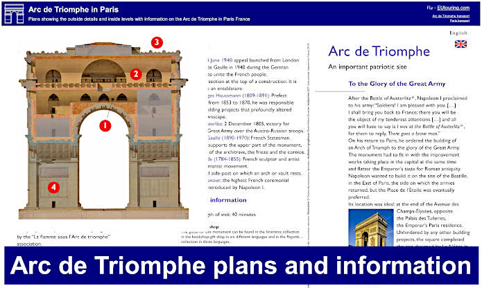
Arc de Triomphe plans of the outside details and inside levels
However, here you can see a visitors guide to the Arc de Triomphe with plans show the key features of the outside and also the different levels inside this famous monument, which provides information on each section of the triumphal arch commissioned by Napoleon Bonaparte.
There is also additional practical information, although in the past it would have meant negotiating hundreds of steps to the room holding the museum portraying the history of the Arc de Triomphe and to the terrace, you may be pleased to know that there has now been a lift, or elevator, installed as well making this one of the Paris landmarks accessible to those with reduced mobility and wheelchair users.
Paris Arc de Triomphe plans and information available: