How to get to Sacre Coeur Basilica in Paris using public transport
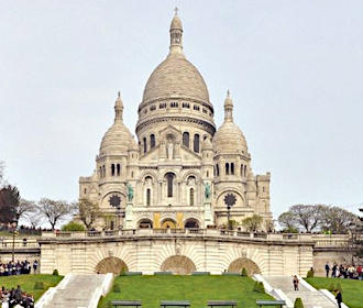
Sacre Coeur Basilica is the famous edifice located at the top of Montmartre in Paris, which is a fully functioning Catholic church holding mass, etc. Popular for both tourists and pilgrims, here you can see all the options for how to get to Sacre Coeur Basilica utilising public transport with street maps, timetables and guides that can all be downloaded by PDF or image formats to your PC or mobile device.
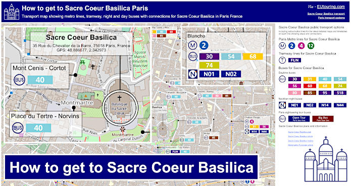
Sacre Coeur Basilica transport map of Metro lines, tramways, bus lines with stops, connections and street plan
Even though the Sacre Coeur Basilica is located at the top of the hill known as the Butte Montmartre where there are 270 steps to reach it but the panoramic views are outstanding and rewarding, there are also options to avoid these including the funicular, which is like a cable car, along with Paris bus line 40 that replaced the Montmartrobus, and here you can see a map showing the location of the basilica along with the closest metro lines, bus lines with the bus stops, etc.
How to get to Sacre Coeur Basilica public transport maps available:
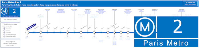
Paris Metro Line 2 map with stations, connections and points of interest
Here we have the Paris Metro line 2, which travels between Porte Dauphine and Nation, which is one of the options for getting to the Arc de Triomphe via the Charles de Gaulle - Etoile stop, yet as you can see from the maps, the closest Metro station to Sacre Coeur Basilica is the Anvers stop, which is also nearest to the Funiculaire de Montmartre funicular.
Metro Line 2 stops:
Porte Dauphine, Victor Hugo, Charles de Gaulle - Etoile, Ternes, Courcelles, Monceau, Villiers, Rome, Place de Clichy, Blanche, Pigalle, Anvers, Barbes - Rochechouart, La Chapelle, Stalingrad, Jaures, Colonel Fabien, Belleville, Couronnes, Menilmontant, Pere Lachaise, Philippe Auguste, Alexandre Dumas, Avron, Nation.
Metro line 2 main transport connections:
Metro Lines: 1, 3, 4, 5, 6, 7, 7bis, 9, 11, 12, 13. Train Lines: A, B, C, D, E, H, K, Funiculaire du Montmartre.
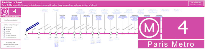
Paris Metro Line 4 map with stations, connections and points of interest
Whereas this shows the maps for the Metro line 4 travelling from Porte de Clignancourt through to Bagneux Lucie Aubrac that has numerous stops with transport connections on route such as Chatelet, which is an option for getting to Paris tourist attractions like the Pompidou Centre, but for Sacre Coeur Basilica the nearest Metro stations are those of Chateau Rouge and Barbes - Rochechouart, but would require a fairly strenuous walk through Montmartre.
Metro line 4 stops:
Porte de Clignancourt, Simplon, Marcadet - Poissonniers, Chateau Rouge, Barbes - Rochechouart, Gare du Nord, Gare de l'Est, Chateau d'Eau, Strasbourg - Saint-Denis, Reaumur - Sebastopol, Etienne Marcel, Les Halles, Chatelet, Cite, Saint-Michel, Odeon, Saint-Germain-des-Pres, Saint-Sulpice, Saint-Placide, Montparnasse - Bienvenue, Vavin, Raspail, Denfert-Rochereau, Mouton-Duvernet, Alesia, Porte d'Orleans, Mairie de Montrouge, Barbara, Bagneux Lucie Aubrac.
Metro line 4 main transport connections:
Metro Lines: 1, 2, 3, 5, 6, 7, 8, 9, 10, 11, 12, 13, 14. Train Lines: A, B, C, D, E, H, K, N, P. Tram Lines: T3a, T3b. Bus Line: OrlyBus.
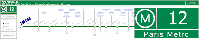
Paris Metro Line 12 map with stations, connections and points of interest
Alternatively, you have the Metro line 12 going between Mairie d'Aubervilliers and Mairie d'Issy with stops at Pigalle and Abessess close to popular places including being an option for getting to La Cigale entertainment venue and the I Love You Wall, yet on the opposite side of Butte Montmartre hill you have the Lamarck - Caulaincourt Metro station close to the Musee de Montmartre and Le Passe-Muraille, and all of these stops will provide you with a lovely walk of approximately 800 metres to Sacre Coeur Basilica.
As a point of interest, for those of you interested in history and art, you will be able to discover two very different Metro station entrances at Pigalle Metro station, one which was designed in an Art Nouveau style by the architect Hector Guimard that was installed in 1902, and the other is in the Art Deco style, which was installed in 1910.
Metro line 12 stops:
Mairie d'Aubervilliers (Plaine des Vertus), Aime Cesaire, Front Populaire, Porte de la Chapelle, Marx Dormoy, Marcadet - Poissonniers, Jules Joffrin, Lamark - Caulaincourt, Abessesses, Pigalle, Saint-Georges, Notre-Dame-de-Lorette, Trinite - d'Estienne d'Orves, Saint-Lazare, Madeleine, Concorde, Assemblee Nationale, Solferino, Rue du Bac, Sevres - Babylone, Rennes, Notre-Dame-des-Champs, Montparnasse - Bienvenue, Falguire, Pasteur, Volontaires, Vaugirard, Convention, Porte de Versailles, Corentin Celton, Mairie d'Issy.
Metro line 12 main transport connections:
Metro Lines 1, 2, 3, 4, 6, 8, 10, 13, 14. Train Lines: C, E, J, L, N, Funiculaire de Montmartre. Tram Lines: T2, T3a, T3b.
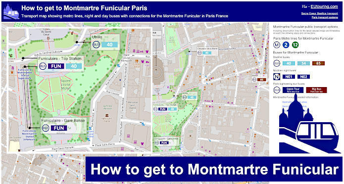
Montmartre Funicular tramway map for Sacre Coeur Basilica
However, here you have the map showing the Funiculaire de Montmartre, or the Funicular, which is basically a cable car that will take you from the bottom of the Butte Montmartre hill at Gare Basse to right near the top of the hill where you can reach the parvis, or square, of Sacre Coeur Basilica very easily also avoiding numerous hundreds of steps.
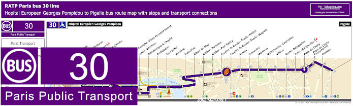
RATP Paris bus line 30 with stops, connections and route plan
Now the Paris bus line 30 is one of the options for how to get to the Eiffel Tower via the Tour Eiffel stop, and as you can see from the street maps and timetables, this bus route that travels between Hopital Europeen Georges Pompidou and Pigalle is also great for getting to many other places including the Moulin Rouge cabaret via the Blanche stop and Sacre Coeur Basilica via the terminus of the Pigalle bus stop.
Paris bus line 30 stops:
Hopital Europeen Georges Pompidou, Rue Leblanc, Leblanc - Delbarre*, Place Balard, Parc Andre Citroen, Cauchy, Javel, Pont de Grenelle-Place Fernand Forest*, Linois - Emeriau*, Bibliotheque A. Chedid*, Bir-Hakeim, Tour Eiffel, Varsovie, Trocadero, Albert de Mun, Kleber - Boissiere, Kleber - Paul Valery, Charles de Gaulle - Etoile - Kleber, Charles de Gaulle - Etoile - Wagram, Ternes, Courcelles, Monceau, Malesherbes - Courcelles, Villiers, Rome - Batignolles, Turin - Batignolles, Place de Clichy, Place de Clichy - Caulincourt**, Blanche, Pigalle.
* Served in direction of Pigale. ** Served in direction of Hopital Europeen Georges Pompidou.
Paris bus line 30 main transport connections:
Metro Lines: 1, 2, 3, 6, 8, 9, 10, 12, 13. Train Lines: A, C. Tram Line: T3a.
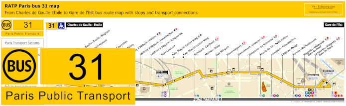
RATP Paris bus line 31 with stops, connections and street plan
However, the Paris bus line 31 travels from Charles de Gaulle - Etoile to Gare de l'Est train station and as you can see from these street maps and timetables, the nearest bus stop to Sacre Coeur Basilica is the Mairie du 18e - Jules Joffrin stop, although you could always utilise the Marcadet - Poissonniers bus stops as well.
Paris bus line 31 stops:
Charles de Gaulle - Etoile, Charles de Gaulle - Etoile - Wagram**, Hoche - Saint-Honore*, Ternes, Wagram - Courcelles, Wagram - Prony, Jouffroy d'Abbans - Villiers, Jouffroy d'Abbans - Malesherbes, Jouffroy d'Abbans - Tocqueville, Pont Cardinet, Parc Martin Luther King**, Parc Martin Luther King*, Brochant - Cardinet, Moines - Davy, Guy Moquet, Vauvenargues, Damremont - Ordener, Duhesme - Le Ruisseau, Mairie du 18e - Jules Joffrin, Marcadet - Poissonniers, Chateau Rouge, Barbes - Rochechouart, Magenta - Maubeuge - Gare du Nord, La Fayette - Magenta - Gare du Nord, Gare de l'Est.
* Served in direction of Charles de Gaulle - Etoile. ** Served in direction of Gare de l'Est.
Paris bus line 31 main transport connections:
Metro Lines: 1, 2, 3, 4, 5, 6, 7, 12, 13, 14. Train Lines: A, B, D, E, H, K, L, P.
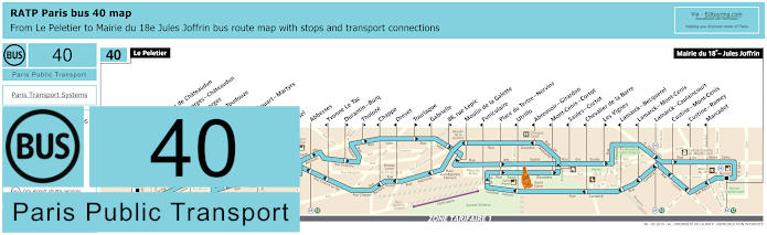
RATP Paris bus line 40 with stops, connections and route plan
Most people think of Montmartrobus that travels around the areas of Montmartre Paris, yet this has been replaced with the Paris line 40 run by the transport company RATP, with the route also now extended and going from Le Peletier through to Mairie du 18e - Jules Joffrin, although we would like to point out that this service is still not disabled friendly.
But, as you can see from the street maps and timetables, there are numerous bus stops that are only served in a particular direction, including the Utrillo stop at only around 30 metres away from this famous Paris monument, which is of course the closest, although there is the Place du Tertre - Norvins bus stop, which will get you approximately 200 metres from Sacre Coeur Basilica and travels in both directions.
Paris bus line 40 stops:
Le Peletier, Carrefour de Chateaudun, Saint-Georges - Chateaudun, Saint-Georges, Gustave Toudouze, Navarin, Rochechouart - Martyrs, Pigalle, Martyrs, Orsel, Abbesses, Yvonne Le Tac, Durantin - Burq, Tholoze, Chappe, Drevet, Tourlaque, Gabrielle, 88, rue Lepic, Moulin de la Galette, Funiculaire, Place du Tertre - Norvins, Utrillo, Abreuvoir - Girardon, Mont-Cenis - Cortot, Saules - Cortot, Chevalier de la Barre, Les Vignes, Lamarck - Becquerel, Lamarck - Mont-Cenis, Lamarck - Caulaincourt, Custine - Mont-Cenis, Custine - Ramey, Marcadet, Mairie du 18e - Jules Joffrin.
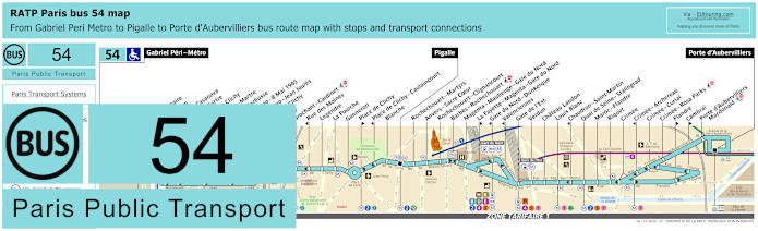
RATP Paris bus line 54 with stops, connections and street plan
Whereas here you have the RATP bus line 54 that travels from Gabriel Peri - Metro in ticket tariff zone 3 passing through zone 2 to zone 1 for Pigalle and then on to Porte d'Aubervilliers, and as you can see from the maps and timetables that vary depending upon the time of year, the nearest stop to Sacre Coeur Basilica is the Anvers - Sacre Coeur bus stop that is also close to the funicular and Metro line 2.
Paris bus line 54 stops:
Gabriel Peri - Metro, Place Voltaire, Leon Blum, Danielle Casanova**, Landy - Martre*, Mairie de Clichy, Barbusse - Martre*, Jaures - Barbusse**, Victor Hugo - 8 Mai 1945*, Victor Hugo - Jean Jaures**, Porte de Clichy, Boulay, Brochant - Cardinet, Rue des Moines*, Legendre, La Fourche, Ganneron, Place de Clichy**, Place de Clichy - Caulaincourt*, Blanche, Pigalle, Rochechouart - Martyrs, Anvers - Sacre Coeur, Rochechouart - Clignancourt, Barbes - Rochechouart, Magenta - Maubeuge - Gare du Nord, La Fayette - Magenta - Gare du Nord**, Gare du Nord - Dunkerque*, Valenciennes*, Gare de l'Est, Verdun, Chateau Landon, Louis Blanc, Chaudron - Saint-Martin*, Quai de Seine - Stalingrad, Maroc - Flandre, Riquet, Crimee, Crimee - Archereau*, Crimee - Curial, Crimee - Rosa Parks, Flandre**, Cambrai**, Porte d’Aubervilliers - Macdonald, Porte d'Aubervilliers.
* Served in direction of Gabriel Peri - Metro. ** Served in direction of Porte d'Aubervilliers.
Paris bus line 54 main transport connections:
Metro Lines: 2, 4, 5, 7, 7bis, 12, 13, 14. Train Lines: B, C, D, E, H, K, P. Tram Line: T3b.
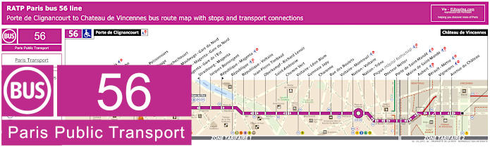
RATP Paris bus line 56 with stops, connections and street plan
Travelling from Porte de Clignancourt, the RATP Paris bus line 56 is one of the options you have for getting to Chateau de Vincennes via its second terminus point of the same name, and as you can see from the street maps and timetables, this is also an option for Sacre Coeur Basilica via either the Marcadet - Poissonniers or Chateau Rouge bus stops, not forgetting the stops with numerous Paris public transport connections on its route as well.
Paris bus line 56 stops:
Porte de Clignancourt, Mont-Cenis*, Albert Kahn, Simplon, Marcadet - Poissonniers, Chateau Rouge, Barbes - Rochechouart, Magenta - Maubeuge - Gare du Nord, La Fayette - Magenta - Gare du Nord, Magenta - Gare de l’Est, Strasbourg - Magenta*, Jacques Bonsergent, Republique - Magenta*, Republique, Republique - Voltaire, Jean-Pierre Timbaud, Oberkampf - Richard Lenoir, Saint-Ambroise, Chemin Vert, Voltaire - Leon Blum, Gymnase Japy, Charonne, Rue des Boulets, Voltaire - Montreuil, Nation - Voltaire, Nation - Trone, Picpus (Hopital Rothschild), Docteur Netter, Porte de Saint-Mande, Mairie de Saint-Mande, Aubert, Berault - Metro, Vignerons, Avenue du Chateau, Chateau de Vincennes.
* Bus stop is direction dependant.
Paris bus line 56 main transport connections:
Metro Lines: 1, 2, 3, 4, 5, 6, 8, 9, 11, 12. Train Lines: A, B, D, E, H, K. Tram Line: T3b.
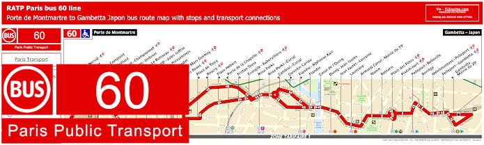
RATP Paris bus line 60 with stops, connections and route plan
However, here we have the maps and timetables for the Paris bus line 60 that goes between Porte de Montmartre and Gambetta - Japon, and this is one of the options for getting to the Grande Halle and Parc de la Villette via the Canal de l'Ourcq or Orcq - Jean Jaures bus stops, but for Sacre Coeur Basilica you would need either the Mairie du 18e - Jules Joffrin or Marcadet - Poissonniers bus stops.
Paris bus line 60 stops:
Porte de Montmartre, Gerard de nerval*, Rene Binet, Angelique Compoint, Poteau - Belliard, Damremont - Championnet, Damremont - Ordener, Duhesme - Le Ruisseau, Mairie du 18e - Jules Joffrin, Marcadet - Poissonniers, Pont Marcadet, Ordener - Marx Dormoy, Les Roses*, Place de Torcy*, Boucry*, Place Hebert*, Porte de la Chapelle*, Tristan Tzara*, Evangile - Aubervilliers, Rosa Parks, Rosa Parks - Curial, Cambrai - Curial*, Corentin Cariou*, Flandre - Alphonse Karr*, Flandre, Canal de l'Ourcq, Ourcq - Jean Jaures, Jean Jaures - Lorraine, Laumiere, Armand Carrel - Mairie du 19e, Manin, Botzaris, Place des Fetes, Pixerecourt, Pelleport - Belleville, Borrego, Menilmontant - Pelleport, Pelleport - Gambetta, Gambetta - Mairie du 20e, Gambetta - Japon.
* Please check maps as these stops are direction dependant.
Paris bus line 60 main transport connections:
Metro Lines: 3, 3bis, 4, 5, 7, 7bis, 11, 12. Train Lines: E. Tram Lines: T3a, T3b.
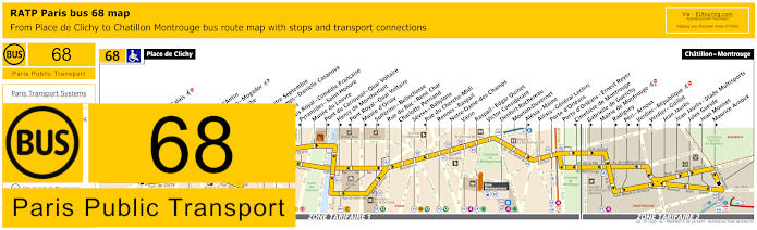
RATP Paris bus line 68 with stops, connections and street plan
Alternatively, the bus line 68 will also get you to many famous Paris landmarks and tourist attractions like getting to the Musee du Louvre and the Musee d'Orsay, not forgetting the Sacre Coeur Basilica, but please take note of the maps and timetables carefully as you would need the Blanche bus stop if travelling in the direction of Chatillon - Montrouge or use the Liege stop if heading towards Place de Clichy.
Paris bus line 68 stops:
Place de Clichy, Blanche**, Blanche - Calais**, Liege*, Moncey**, Trinite, Chaussee d'Antin**, Haussmann - Mogador*, Opera - Scribe**, Opera*, Opera - Quatre Septembre, Petits Champs - Danielle Casanova*, Pyramides, Palais Royal - Comedie Francaise**, Pyramides - Saint-Honore*, Musee du Louvre, Pont du Carrousel - Quai Voltaire**, Henry de Montherlant**, Pont Royal - Quai Voltaire*, Musee d'Orsay**, Solferino - Bellechasse**, Rue du Bac - Rene Char, Charlotte Perriand, Sevres - Babylone, Rue du Cherche-Midi*, Rennes - Raspail, Notre-Dame-des-Champs, Vavin, Raspail - Edgar Quinet, Victor Considerant, Denfert-Rochereau, Mouton-Duvernet, Alesia - Maine**, Alesia - General Leclerc, Porte d'Orleans, Porte d'Orleans - Ernest Reyer, Cimetiere de Montrouge*, Gabrielle de Guerchy**, Mairie de Montrouge, Radiguey**, Peri - Arnoux**, Verdier - Republique*, Verdier - Guillot*, Jean Jaures, Jean Jaures - Stade Multisports**, Jules Guesde, Jean Monnet*, Maurice Arnoux**, Chatillon - Montrouge.
* Stop served in direction of Place de Clichy. ** Stop served in direction of Chatillon - Montrouge.
Paris bus line 68 main transport connections:
Metro Lines: 1, 2, 3, 4, 6, 7, 9, 10, 12, 13, 14. Train Lines: A, B, C. Tram Lines: T3a, T6.
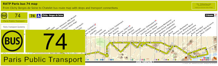
RATP Paris bus line 74 with stops, connections and street plan
Yet the RATP bus line 74 goes from Clichy - Berges de Seine in ticket tariff zone 2 through to Chatelet in Paris zone 1, and it is this terminus that you could utilise as an option for getting to Le Duc des Lombards Jazz Club, although for getting to Sacre Coeur Basilica you would need the Blanche bus stop, which does travel in both directions but at different bus stops as you can see from the street maps and timetables.
Paris bus line 74 stops:
Clichy - Berges de Seine, Claude Debusy**, Hopital Beaujon, General Leclerc - Villeneuve - Hop. Beaujon, Republique - Francois Mitterrand, General Leclerc - Victor Hugo, Curton, Victor Hugo - Jean Jaures, Porte de Clichy, Boulay, Brochant - Cardinet, Rue des Moines*, Legendre, La Fourche, Ganneron, Place de Clichy - Caulaincourt*, Place de Clichy**, Blanche, Blanche - Calais**, Pigalle - Chaptal*, La Bruyere**, Saint-Georges, Saint-Georges - Chateaudun**, Carrefour de Chateaudun, Provence - Drouot**, Provence - Faubourg Montmartre*, Richelieu - Drouot - Mairie du 9e**, Richelieu - 4 Septembre**, Grands Boulevards*, Bourse**, Reaumur - Montmartre, Louvre - Etienne Marcel, Bourse de Commerce, Louvre - Rivoli, Rivoli - Pont Neuf*, Pont Neuf - Quai du Louvre**, Rivoli - Chatelet*, Chatelet.
* Stop served in direction of Clichy - Berges de Seine. ** Stop served in direction of Chatelet.
Paris bus line 74 main transport connections:
Metro Lines: 1, 2, 3, 4, 7, 8, 9, 11, 12, 13, 14. Train Lines: A, B, C, D. Tram Line: T3b.
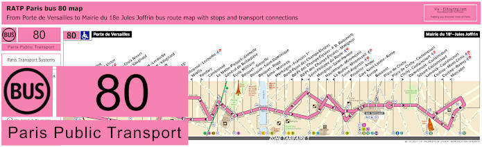
RATP Paris bus line 80 with stops, connections and street plan
Ideal for getting to Le Dome de Paris or the Parc des Expositions Paris Expo via the Porte de Versailles terminus, the bus line 80 travels through to Mairie du 18e - Jules Joffrin, which is the opposite terminus and one option for how to get to Sacre Coeur Basilica, although as you can see from the maps and timetables, the Lamarck - Caulaincourt and Custine - Mont-Cenis bus stops are actually closer to this church and many other attractions with the Montmartre area.
Paris bus line 80 stops:
Porte de Versailles, Firmin Gillot**, Boulevard Victor*, Hameau*, Vaugirard - Croix Nivert**, Hopital de Vaugirard**, Duranton*, Convention - Lecourbe*, Convention - Vaugirard**, Abbe Groult, Vaugirard**, Mairie du 15e, Peclet**, Cambronne - Lecourbe*, Miollis*, Fondary**, Cambronne, La Motte-Picquet - Grenelle, General de Bollardiere, Ecole Militaire, Bosquet - Grenelle, Bosquet - Saint-Dominique, Bosquet - Rapp, Alma - Marceau, Montaigne - Francois 1er, Rond-Point des Champs-Elysees, Rd-Pt des Champs-Elysees - F. D. Roosevelt*, Rd-Pt des Champs-Elysees - Matignon**, Saint-Philippe du Roule*, Matignon - Saint-Honore**, Haussmann - Miromesnil**, La Boetie - Miromesnil*, Saint-Augustin, Pasquier - Anjou*, Gare Saint-Lazare - Rome, Europe, Bucarest, Place de Clichy, Place de Clichy - Caulaincourt*, Clichy - Caulaincourt**, Damremont - Caulaincourt, Square Caulaincourt, Lamarck - Caulaincourt, Custine - Mont-Cenis, Custine - Ramey*, Marcadet*, Mairie du 18e - Jules Joffrin.
* Stop served in direction of Porte de Versailles. ** Stop served in direction of Mairie du 18e - Jules Joffrin.
Paris bus line 80 main transport connections:
Metro Lines: 1, 2, 3, 6, 8, 9, 10, 12, 13, 14. Train Lines: C, E, J, L. Tram Lines: T2, T3a.
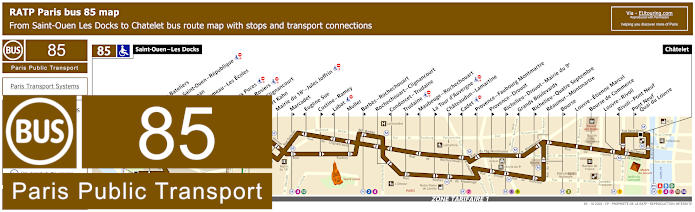
RATP Paris bus line 85 with stops, connections and street plan
Whereas this shows the maps and timetables for bus line 85 going between Saint-Ouen - Les Docks and Chatelet, yet please look at the maps and timetables carefully, because at certain times the terminus changes, as does the time between buses, not forgetting that many bus stops are direction dependent, or, just like the Muller stop you would need for getting to Sacre Coeur Basilica, the bus stops are in a slightly different place.
Paris bus line 85 stops:
Saint-Ouen - Les Docks, Parvis des Bateliers, Mairie de Saint-Ouen - Republique, Ernest Renan, Eugene Lumeau - Les Ecoles, Paul Bert, Marche aux Puces, Michelet - Rosiers, Porte de Clignancourt, Albert Kahn, Mairie du 18e - Jules Joffrin, Marcadet**, Eugene Sue*, Custine - Ramey**, Labat*, Muller, Barbes - Rochechouart**, Rochechouart - Clignancourt, Condorcet - Trudaine*, Trudaine**, Maubeuge - Rochechouart*, La Tour d’Auvergne**, Chateaudun - Lamartine**, Cadet*, Provence - Faubourg Montmartre*, Provence - Drouot**, Richelieu - Drouot - Mairie du 9e**, Grands Boulevards*, Richelieu - Quatre Septembre**, Reaumur - Montmartre, Bourse**, Louvre - Etienne Marcel, Bourse de Commerce, Louvre - Rivoli, Rivoli - Pont Neuf*, Pont Neuf - Quai du Louvre**, Chatelet.
* Stop served in direction of Saint-Ouen - Les Docks. ** Stop served in direction of Chatelet, Paris.
Paris bus line 85 main transport connections:
Metro Lines: 1, 2, 3, 4, 7, 8, 9, 11, 12, 13, 14. Train Lines: A, B, D. Tram Line: T3b.
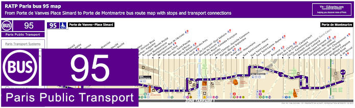
RATP Paris bus line 95 with stops, connections and street plan
The Paris bus line 95 travels between Porte de Vanves - Place Simard and Porte de Montmartre with stops on route at train stations like Gare Saint-Lazare and Gare Montparnasse, but there are several bus stops on route that only travel in a certain direction, yet you can utilise the Damremont - Caulaincourt bus stop for Sacre Coeur Basilica, as you can see from the street maps and timetables.
Paris bus line 95 stops:
Porte de Vanves - Place Simard, Adolphe Pinard*, Pont de la Vallee*, Bartholome*, Porte de Vanves**, Brancion*, Chauvelot**, Morillons - Brancion*, Morillons**, Brancion - Vouille*, Labrouste - Vouille**, Alleray*, Falguiere**, Procession*, Institut Pasteur, Pasteur - Docteur Roux*, Pasteur - Falguiere**, Armorique - Musee Postal, Gare Montparnasse, Montparnasse - Rue de l'Arrivee*, Montparnasse**, Rennes - Littre, Rennes - Saint-Placide, Rennes - d'Assas, Michel Debre, Saint-Germain-des-Pres, Jacob, Pont du Carrousel - Quai Voltaire, Musee du Louvre, Palais Royal - Comedie Francaise, Pyramides, Petits Champs - Danielle Casanova**, Opera - Quatre Septembre, Opera, Auber, Havre - Haussmann*, Gare Saint-Lazare - Havre*, Gare Saint-Lazare**, Gare Saint-Lazare - Rome, Europe, Bucarest, Place de Clichy, Place de Clichy - Caulaincourt*, Clichy - Caulaincourt**, Damremont - Caulaincourt (Sacre-Coeur), Damremont - Lamarck**, Place Jacques Froment, Damremont - Marcadet, Damremont - Ordener, Damremont - Championnet, Poteau - Belliard, Angelique Compoint, Rene Binet, G. de Nerval**, Porte de Montmartre.
* Stop served in direction of Porte de Vanves - Place Simard. ** Stop served in direction of Porte de Montmartre.
Paris bus line 95 main transport connections:
Metro Lines: 1, 2, 3, 4, 6, 7, 8, 9, 10, 12, 13, 14. Train Lines: A, E, J, L, N. Tram Line: T3a.
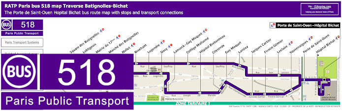
RATP Paris bus line 518 with stops, connections and street plan
When it comes to the bus line 518, which is also known as La Traverse Batignolles-Bichat, Traverse B-B and also Batigno, you will find that this goes round in a loop from Porte de Saint-Ouen - Hopital Bichat and hence all bus stops go in one direction, and for the Sacre Coeur Basilica, the nearest bus stop is the Hopital Bretonneau bus stop at around 1300 metres walk away.
Paris bus line 518 stops:
Porte de Saint-Ouen - Hopital Bichat, Porte de Saint-Ouen, Vauvenargues, Firmin Gemier, Jacques Cartier, Guy Moquet, Coysevox, Hopital Bretonneau, Lamarck - Guy Moquet, Davy, Legendre, Nollet, Mairie du 17eme, Lobligeois, Square des Batignolles, Marche des Batignolles, Brochant, College Mallarme, Lantiez, Leclaire, Hopital Bichat*.
* Stop only served in the direction of Porte de Saint-Ouen - Hopital Bichat.
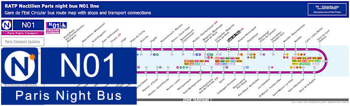
Paris Noctilien night bus N01 map with stops and transport connections
You will find that the Noctilien are the Paris night buses that operate between around the hours of 12:30am and 5:30am when other public transport has stopped for the night, and here you can see the maps and timetables for Noctilien N01, which is classed as the Circulaire Interieure travelling in a complete circuit from Gare de l'Est train station. Stopping at numerous tourist attractions and key places for getting to Bastille or from this lively area, for Sacre Coeur Basilica and Montmartre you could utilise the night bus stops Anvers - Sacre Coeur being the closest, but also Blanche, Pigalle and Barbes - Rochechouart, etc.
Paris night bus line N01 stops:
Gare de l'Est, Jacques Bonsergent, Republique, Oberkampf - Filles du Calvaire, Saint-Gilles - Chemin Vert, Bastille - Beaumarchais, Bastille, Lyon - Ledru-Rollin, Gare de Lyon - Diderot, Quai de la Rapee, Gare d'Austerlitz, Saint-Marcel - La Pitie, Saint-Marcel - Jeanne d'Arc, Les Gobelins, Port Royal - Berthollet, Observatoire - Port Royal, Campagne Premiere, Vavin, Montparnasse - Rue de l'Arrivee, Gare Montparnasse, Montparnasse, Rennes - Littre, Rennes - Saint-Placide, Rennes - d'Assas, Michel Debre, St-Germain-des-Pres, Pont du Carrousel - Quai Voltaire, Henry de Montherlant, Assemblee Nationale, Pont Alexandre III, Palais de la Decouverte, Rond-Point des Champs-Elysees - Matignon, Haussmann - Miromesnil, Saint-Augustin, Gare Saint-Lazare, Trinite, Liege, Place de Clichy, Blanche, Pigalle, Rochechouart - Martyrs, Anvers - Sacre-Coeur, Rochechouart - Clignancourt, Barbes - Rochechouart, Magenta - Mauberge - Gare du Nord, La Fayette - Magenta - Gare du Nord, Gare de l'Est.
Paris night bus line N01 main transport connections:
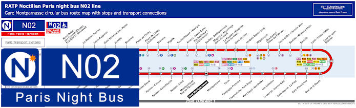
Paris Noctilien night bus N02 map with stops and transport connections
Whereas these maps and timetables show the Paris Noctilien N02 night bus line that is known as the Circulaire Exterieure, also travelling in a complete circuit but from Gare Montparnasse train station, and again the closest night bus stop to Sacre Coeur Basilica is the Anvers - Sacre Coeur stop, yet this also goes to key places like Gare de Lyon train station, where you can catch many transport connections.
Paris night bus line N02 stops:
Gare Montparnasse, Montparnasse, Vavin, Campagne Premiere, Observatoire - Port Royal, Port Royal - Berthollet, Les Gobelins, Saint-Marcel - Jeanne d'Arc, Saint-Marcel - La Pitie, Gare d'Austerlitz, Quai de la Rapee, Gare de Lyon - Diderot, Lyon - Ledru-Rollin, Bastille, Bastille - Beaumarchais, Saint-Gilles - Chemin Vert, Oberkampf - Filles du Calvaire, Republique, Jacques Bonsergent, Gare de l'Est, La Fayette - Magenta - Gare du Nord, Magenta - Maubeuge - Gare du Nord, Barbes - Rochechouart, Rochechouart - Clignancourt, Anvers - Sacre-Coeur, Rochechouart - Martyrs, Pigalle, Blanche, Place de Clichy - Caulaincourt, Place de Clichy, Bucarest, Europe, Gare Saint-Lazare - Rome, Saint-Augustin, La Boetie - Percier, Rond-Point des Champs-Elysees - Franklin D. Roosevelt, Palais de la Decouverte, Pont Alexandre III, Assemblee Nationale, Solferino - Bellechasse, Saint-Guillaume, Saint-Germain-des-Pres, Michel Debre, Rennes - d'Assas, Rennes - Saint-Placide, Rennes - Little, Montparnasse - Rue de l'Arrivee, Gare Montparnasse.
Paris night bus line N02 main transport connections:
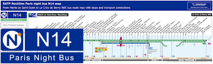
Paris Noctilien night bus N14 map with stops and transport connections
Then you have the Paris Noctilien N14 bus line that travels from Mairie de Saint-Ouen through Paris and into commune of the Paris region including Bagneux and Sceaux before reaching La Croix de Berny RER in the Antony area within ticket tariff zone 3, and as you can see from the maps and timetables you can choose between Chateau Rouge and Barbes - Rochechouart for Sacre Coeur Basilica, but please bear in mind some night bus stops are direction dependent.
Paris night bus line N14 stops:
Mairie de Saint-Ouen - Republique, Ernest Renan, Garibaldi, Kleber, Gerard de Nerval, Angelique Compoint, Camille Flammarion, Porte de Clignancourt, Simplon, Marcadet - Poissonniers, Chateau Rouge, Barbes - Rochechouart, Magenta - Mauberge - Gare du Nord, La Fayette - Magenta - Gare du Nord, Gare de l'Est, Magenta - Saint Martin*, Chateau d'Eau**, Mairie du 10e*, Porte Saint-Martin*, Strasbourg - Saint-Denis**, Reaumur - Sebastopol**, Reaumur - Arts et Metiers*, Turbigo - Etienne Marcel**, Grenier St-Lazare - Quartier de l'Horloge*, Les Halles - Centre Georges Pompidou**, Centre Georges Pompidou*, Chatelet, Cite - Palais de Justice, Saint-Michel - Saint-Germain, Les Ecoles, Luxembourg, Auguste Comte, Val du Grace, Observatoire - Port Royal, Hopital Saint-Vincent de Paul, Denfert-Rochereau -Arago, Denfert-Rochereau*, Denfert-Rochereau - Daguerre**, Mouton - Duvernet, Alesia - Maine*, Alesia - General Leclerc, Porte d'Orleans, Porte d'Orleans - Metro*, Gabriel Peri, Leon Gambetta, Vache Noire, Jean-Marin Naudin, Gustave Courbet - Metro, Grange Ory, Carnot - Aristide Briand, Marcel Bonnet, Pont Royal - RER, Cite Jardins, Place de la Resistance - Charles de Gaulle, Rue du 8 mai 1945, Bourg-la-Reine RER*, Condorcet - Mairie - RER**, Petit Chambord - Lycee Lakanal, Les Cottages, La Fontaine, Normandie, General de Gaulle - Croix de Berny*, La Croix de Berny RER.
* Bus stop served in direction of La Croix Berny RER. ** Bus stop served in direction of Mairie de Saint-Ouen - Republique.
Paris night bus line N14 main transport connections:
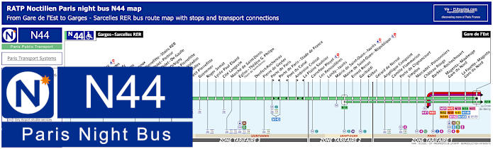
Paris Noctilien night bus N44 map with stops and transport connections
Although the Noctilien night bus line N44 travels from Paris Gare de l'Est in in ticket tariff zone 1 through to Garges - Sarcelles RER in zone 4, with numerous night bus stops on route in various areas including Saint-Denis, and this is one of the options for getting to the Stade de France via the Porte de Paris - Stade de France stop, yet for Sacre Coeur Basilica, the nearest stops would be Chateau Rouge or Barbes - Rochechouart.
Paris night bus line N44 stops:
Garges - Sarcelles RER, Locheres, Paul Valery, Les Flanades, Raoul Dufy, Les Sablons, Jean Grignoux, Gare de Pierrefitte - Stains RER, Etienne Dolet - Pasteur**, Etienne Dolet - De Gaulle*, Alcide d’Orbigny, Mairie de Pierrefitte, Suzanne Valadon, Joncherolles, Petit Pierrefitte, Guynemer, Roger Semat, Lycee Paul Eluard, Cite Langevin, Marche de Saint-Denis, Eglise - Theatre G. Philipe (Gare de Saint-Denis), Denfert-Rochereau, Pierre de Geyter, Porte de Paris*, Porte de Paris - Stade de France**, Pont du Canal**, Ambroise Croizat*, La Plaine Saulnier**, Carrefour Pleyel, Les Renouilleres, Landy - Jaures, Mairie de Saint-Ouen - Jaures, Mairie de Saint-Ouen - Republique, Ernest Renan, Garibaldi, Kleber, Gerard de Nerval, Angelique Compoint, Camille Flammarion, Porte de Clignancourt, Simplon, Marcadet - Poissonniers, Chateau Rouge, Barbes - Rochechouart, Magenta - Maubeuge - Gare du Nord, La Fayette - Magenta - Gare du Nord, Gare de l'Est.
* Bus stop served in direction of Gare de l'Est. ** Bus stop served in direction of Garges - Sarcelles RER.
Paris night bus line N44 main transport connections:
Metro Lines: 2, 4, 5, 12, 13. Train Lines: B, D, E, H, K. Tram Lines: T1, T3b, T5, T8. Bus Lines: N01, N02, N13, N14, N41, N42, N43, N45, N140, N141, N142, N143, Fileo Buses.
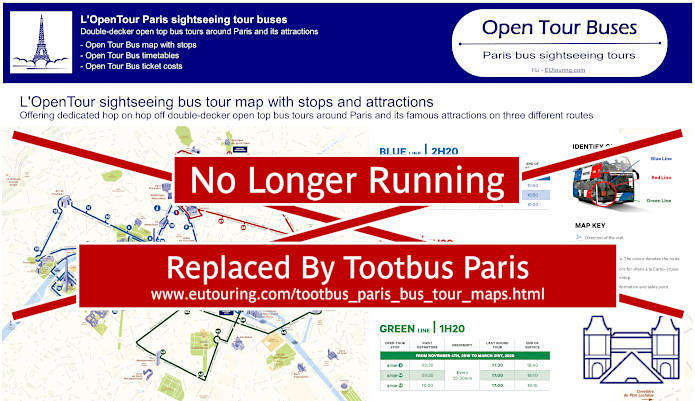
Paris Open Tour bus sightseeing tour map for Blue, Red and Green bus lines with stops and timetables
Many people wish to discover as much possible while on holiday in Paris, and one of the great options is by going on a sightseeing tour, and you will be pleased to know that there is a company called OpenTour that offer a hop on and hop off sightseeing bus tour service where you can stop at as many tourist attractions as you like and jump back on the buses to see others.
So here you can see the maps along with timetables, information and ticket costs for OpenTour, along with their 3 different routes and for getting to Sacre Coeur Basilica you would need the Red bus tour line called the Montmarte Grand Boulevards route and Stop 32 called Montmartre - Sacre-Coeur located at 68 Boulevard de Rochechouart, 75018.
1: Haussmann - Opera - Visitor centre - 13 Rue Auber, 75009 30: Trinite - 32 Rue Mogador, 75009 31: Moulin Rouge - Pigalle - 59 Boulevard de Clichy, 75009 32: Montmartre - Sacre-Coeur - 68 Boulevard de Rochechouart, 75018 33: Gare du Nord - 21 Rue de Dunkerque, 75010 34: Gare de l'Est - 129 Rue du Faubourg St-Martin, 75010 35: Republique - Face au 11 Boulevard Saint-Martin, 75003 36: Bonne Nouvelle - Grand Rex - 36 Boulevard de Bonne-Nouvelle, 75010 37: Grands Boulevards - Hard Rock Cafe - 16 Boulevard Montmartre, 75009
Paris Open Tour bus sightseeing tour maps with stops and timetables:
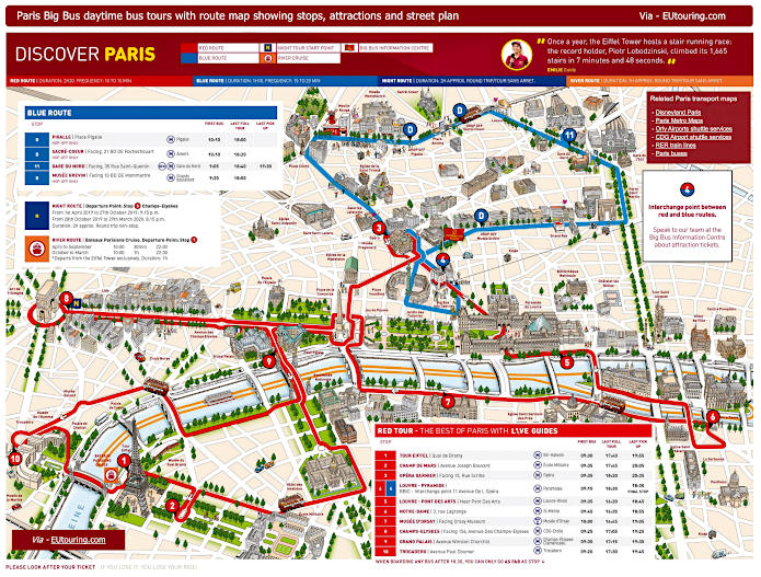
Big Bus Paris sightseeing tour map for Red and Blue bus lines with stops and timetables
However, you also have the sightseeing tour bus company called Big Bus Paris, which also offer a hop on and hop off service, but please take note of the maps and information very carefully, as although the Blue Route travels round the Montmartre area, you will see that the Pigalle stop and the Sacre-Coeur stop are classed as D, which means they are drop off points only and therefore you cannot get back on one of their buses at these locations, meaning you would have to take a long walk to Gare du Nord train station or choose an alternative, such as Paris public transport instead.
4: Louvre-Pyramide / Big Bus Information Centre - 11 Avenue de l’Opera (by Big Bus information centre) 11: Gare du Nord - 35 Rue de Saint-Quentin (facing main entrance of Gare du Nord just off Rue de Dunkerque) 51: Pigalle (HOP OFF ONLY) - Place Pigalle - NOTE: This is a hop-off only stop, so you cannot get back on board here. 52: Sacre-Coeur (HOP OFF ONLY) - facing 21 Boulevard de Rochechouart, then walk to the Funicular) - NOTE: This is a hop-off only stop, so you cannot get back on board here. 53: Musee Grevin (HOP OFF ONLY) - 10 Boulevard Montmartre - NOTE: This is a hop-off only stop, so you cannot get back on board here.
Big Bus Paris daytime sightseeing tour maps with stops and timetables:
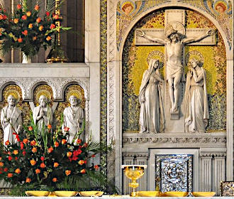
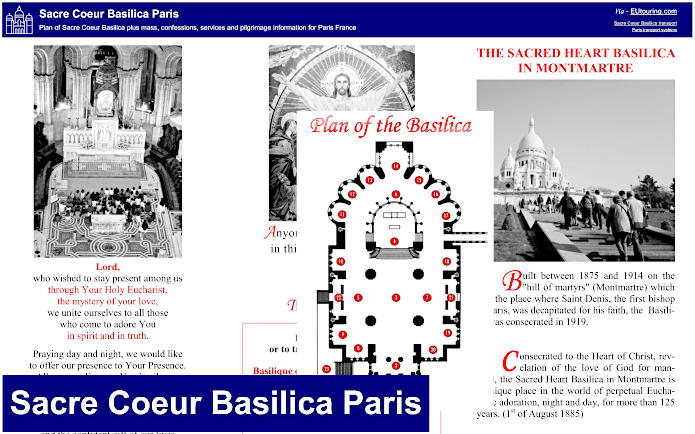
Sacre Coeur Basilica plan including mass and confession times plus pilgrimage information
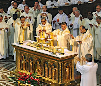
Here you can see an information leaflet showing the layout of the Sacre Coeur Basilica along with information on key points in its history in addition to times of Mass and other services along with confessions, pilgrimage information and more to make your visit the success you want it to be.