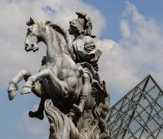
How to get to Louvre Museum in Paris using public transport
The Musee du Louvre is the largest and most famous museum in the world visited by millions every year, and below you can find out how to get to the Louvre former royal palace using public transport, which also includes street maps, timetables, plans and visitor information, that can all be downloaded by PDF or image formats for your PC or mobile device.
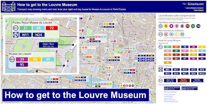
Louvre Museum transport map of Metro lines, trains, bus lines with stops, connections and street plan
This first plan shows a street map for The Louvre, which pin points the various bus stops and Metro stations that will all get you within easy walking distance of this historical Paris monument and museum, so whether you are going to the main entrance at the impressive I M Pei pyramid or to the Carrousel entrance, etc, then you will find the nearest transport options for Musee du Louvre.
How to get to Louvre Museum public transport maps available:
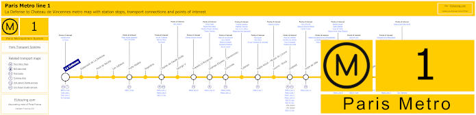
Paris Metro Line 1 map with stations, connections and points of interest
So here you have the Paris Metro line 1 that travels from the medieval castle of Chateau de Vincennes to the transport options for La Defense Grande Arche, which is the modern tourist attraction positioned along the historical Paris axis going from The Louvre, and on route you can see that you have the stop called Palais Royal - Musee du Louvre and another called Louvre - Rivoli.
Also, as a point of interest, the Louvre - Rivoli Metro station was decorated with replicas of works of art from the Louvre Museum along its platforms in the late 1960's, which was the first station to receive any form of cultural aesthetics.
Metro Line 1 stops:
La Defense, Esplanade de La Defense, Pont de Neuilly, Les Sablons, Porte Maillot, Argentine, Charles de Gaulle Etoile, George V, Franklin D Roosevelt, Champs-Elysees - Clemenceau, Concorde, Tuileries, Palais Royal - Musee du Louvre, Louvre - Rivoli, Chatelet, Hotel de Ville, Saint-Paul, Bastille, Gare de Lyon, Reuilly - Diderot, Nation, Porte de Vincennes, Saint-Mande, Berault, Chateau de Vincennes.
Metro line 1 main transport connections:
Metro Lines: 2, 4, 5, 6, 7, 8, 9, 11, 12, 13, 14. Train Lines: A, B, C, D, L, R, U. Tram Lines: T2, T3a, T3b.
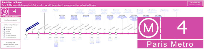
Paris Metro Line 4 map with stations, connections and points of interest
However, this shows the Metro line 4 travelling from Porte de Clignancourt to Bagneux Lucie Aubrac, and as you can see from the Metro 4 maps showing transport connections, for the Louvre Museum you would need either the Les Halles stop or the Chatelet stop, both of which are within easy walking distance of the former fortress turned palace.
Metro line 4 stops:
Porte de Clignancourt, Simplon, Marcadet - Poissonniers, Chateau Rouge, Barbes - Rochechouart, Gare du Nord, Gare de l'Est, Chateau d'Eau, Strasbourg - Saint-Denis, Reaumur - Sebastopol, Etienne Marcel, Les Halles, Chatelet, Cite, Saint-Michel, Odeon, Saint-Germain-des-Pres, Saint-Sulpice, Saint-Placide, Montparnasse - Bienvenue, Vavin, Raspail, Denfert-Rochereau, Mouton-Duvernet, Alesia, Porte d'Orleans, Mairie de Montrouge, Barbara, Bagneux Lucie Aubrac.
Metro line 4 main transport connections:
Metro Lines: 1, 2, 3, 5, 6, 7, 8, 9, 10, 11, 12, 13, 14. Train Lines: A, B, C, D, E, H, K, N, P. Tram Lines: T3a, T3b. Bus Line: OrlyBus.
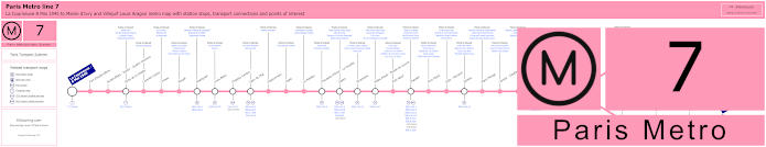
Paris Metro Line 7 map with stations, connections and points of interest
These maps show the Paris Metro line 7 running from La Corneuve - 8 Mai 1945 to Maison Blanch where the line splits and goes to either Mairie d'Ivry or Villejuif - Louis Aragon with Metro stops that have many transport connections including the Gare de l'Est train station, yet when the new Louvre entrance was created with the construction of the Louvre Pyramid, the Palais Royal - Musee du Louvre Metro station for Metro lines 1 and 7 became the main station for how to get to the Musee du Louvre.
This is located at the Place Collette in between Palais Royal and The Louvre, and the first thing you will notice is the artwork by Jean-Michel Othoniel, which was designed as a beaded castle with enchanted crowns and gems to commemorate the 100th anniversary of the Paris Metro along with a tribute to the architect Hector Guimard who designed the first Art Nouveau metro entrances.
Another point of interest is a Shamanic art mural designed as a cultural exchange between Paris RATP and Mexico City Metro and the indigenous Huichol people, which is composed of 80 panels and 2 million 2mm beads that you can discover when leaving the Palais Royal - Musee du Louvre metro station heading towards the Carrousel du Louvre.
Metro line 7 stops:
La Courneuve - 8 Mai 1945, Fort d'Aubervilliers, Aubervilliers - Pantin - Quatre Chemins, Porte de la Villette, Corentin Cariou, Crimee, Riquet, Stalingrad, Louis Blanc, Chateau-Landon, Gare de l'Est, Poissonniere, Cadet, Le Peletier, Chaussee d'Antin - La Fayette, Opera, Pyramides, Palais Royal - Musee du Louvre, Pont Neuf, Chatelet, Pont Marie, Sully - Morland, Jussieu, Place Monge, Censier - Daubenton, Les Gobelins, Place d'Italie, Tolbiac, Maison Blanche, Porte d'Italie, Porte de Choisy, Porte d'Ivry, Pierre et Marie Curie, Mairie d'Ivry, Le Kremlin-Bicetre, Villejuif - Leo Lagrange, Villejuif - Paul Vaillant-Couturier, Villejuif - Louis Aragon.
Metro line 7 main transport connections:
Metro Lines: 1, 2, 3, 4, 5, 6, 7bis, 8, 9, 10, 11, 14. Train Lines: A, B, D, E, P. Tram Lines: T1, T3a, T3b, T7. Bus Line: RoissyBus.
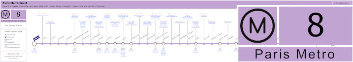
Paris Metro Line 8 map with stations, connections and points of interest
Here we have the Metro line 8 that travels between Balard and Creteil - Pointe du Lac, and as you can see from the maps, you would need the metro station Concorde, then either walk along the Rue de Rivoli or through the historical Tuileries Gardens in order to reach the Musee du Louvre at approximately 1000 to 1200 metres walk from the main entrance.
Metro line 8 stops:
Balard, Lourmel, Boucicaut, Felix Faure, Commerce, La Motte-Picquet - Grenelle, Ecole Militaire, La Tour-Maubourg, Invalides, Concorde, Madeleine, Opera, Richelieu-Drouot, Grands Boulevards, Bonne Nouvelle, Strasbourg - Saint-Denis, Republique, Filles du Calvaire, Saint-Sebastien - Froissart, Chemin Vert, Bastille, Ledru-Rollin, Faidherbe - Chaligny, Reuilly - Diderot, Montgallet, Daumesnil, Michel Bizot, Porte Doree, Porte de Charenton, Liberte, Charenton - Ecoles, Ecole Veterinaire de Maisons-Alfort, Maisons-Alfort - Stade, Maisons-Alfort - Les Juilliottes, Creteil - L'Echat, Creteil - Universite, Creteil - Prefecture, Creteil - Pointe du Lac.
Metro line 8 main transport connections:
Metro Lines: 1, 3, 4, 5, 6, 7, 9, 10, 11, 12, 13, 14. Train Lines: A, C. Tram Lines: T2, T3a. Bus Lines: RoissyBus, TVM (14).
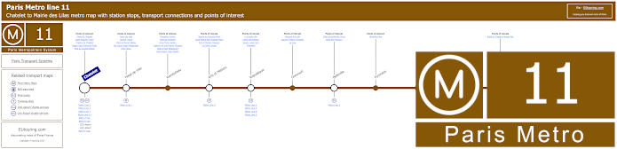
Paris Metro Line 11 map with stations, connections and points of interest
Whereas this shows the Metro Line 11 going from Chatelet, which is the Metro station you would need for The Louvre and its world renowned museum, at a walking distance of around 500 metres, and this line also has various transport connections on its route to Mairie des Lilas.
Metro line 11 stops:
Chatelet, Hotel de Ville, Rambuteau, Arts et Metiers, Republique, Goncourt, Belleville, Pyrenees, Jourdain, Place des Fetes, Telegraphe, Porte des Lilas, Mairie des Lilas.
Metro line 11 main transport connections:
Metro Lines: 1, 2, 3, 3bis, 4, 5, 7, 7bis, 8, 9, 14. Train Linea: A, B, D. Tram Line: T3b.
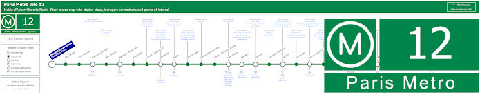
Paris Metro Line 12 map with stations, connections and points of interest
As you can see from these maps, the Metro line 12 goes from Mairie d'Aubervilliers to Mairie d'Issy with numerous stops at key transport hubs including Saint-Lazare and Montparnasse - Bienvenue, yet for the Musee du Louvre you would need the Concorde stop.
Yet for those of you interested in history, human rights and politics on the Line 12 platform you can discover a work created in 1990 by the Belgian artist Francoise Schein, which has 49,000 enameled tiles covering the vaulted ceiling and walls that recites the Declaration of the Rights of Man of 1789 in full, including the text "Men are born and remain free and equal in rights", although as you would no doubt guess, this has been produced in the French language.
Metro line 12 stops:
Mairie d'Aubervilliers (Plaine des Vertus), Aime Cesaire, Front Populaire, Porte de la Chapelle, Marx Dormoy, Marcadet - Poissonniers, Jules Joffrin, Lamark - Caulaincourt, Abessesses, Pigalle, Saint-Georges, Notre-Dame-de-Lorette, Trinite - d'Estienne d'Orves, Saint-Lazare, Madeleine, Concorde, Assemblee Nationale, Solferino, Rue du Bac, Sevres - Babylone, Rennes, Notre-Dame-des-Champs, Montparnasse - Bienvenue, Falguire, Pasteur, Volontaires, Vaugirard, Convention, Porte de Versailles, Corentin Celton, Mairie d'Issy.
Metro line 12 main transport connections:
Metro Lines 1, 2, 3, 4, 6, 8, 10, 13, 14. Train Lines: C, E, J, L, N, Funiculaire de Montmartre. Tram Lines: T2, T3a, T3b.
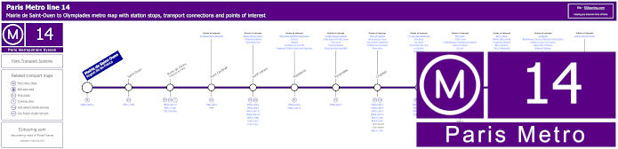
Paris Metro Line 14 map with stations, connections and points of interest
However, here you have the Metro line 14 that is a high-spped automated Metro line travelling between Saint-Lazare and Olympiades with only 7 Metro stations in between, the nearest of these to The Louvre being either the Pyramides stop or the Chatelet stop, both of which are around 500 metres away, although this is also how to get to Madeleine square and church.
Metro line 14 stops:
Mairie de Saint-Ouen (Region Ile-de-France), Saint-Ouen, Porte de Clichy (Tribunal de Paris), Pont Cardinet, Saint-Lazare, Madeleine, Pyramides, Chatelet, Gare de Lyon, Bercy, Cour Saint-Emilion, Bibliotheque Francois Mitterrand, Olympiades.
Metro line 14 main transport connections:
Metro Lines: 1, 3, 4, 6, 7, 8, 9, 11, 12, 13. Train Lines: A, B, C, D, E, J, L, R. Tram Lines: T3a Walk, T3b.
Some attractions close to Metro line 14 stops:
Square Marcel Pagnol, Chapelle Expiatoire, Cafe Marco Polo, Place de la Madeleine and Church, Fauchon, Hediard, La Maison de la Truffe, Fragonard Theatre Musee des Capucines, La Belle Epoque Cabaret, Palais Royal and Petit Canon, The Louvre, Tuileries Gardens, Musee des Arts Decoratifs , Place de Chatelet, Saint-Jacques Tower, Dans la Noir Restaurant, Fontaine des Innocents, River Seine, Le Train Bleu Restaurant, Cafe Barge, Les Docks, l'Improviste Jazz Club, Le Playtime, Le VIP Paris, Bercy Park, POPB Arena, Cinematheque Francaise and Museum, Dame de Canton, Nix Nox, Bercy Village, Yitzhak Rabin Garden, Fairground Museum, Bercy Pavilions, Chai 33 Restaurant, Le Batofar, Bibliotheque Francois Mitterand Forest Garden, Globes of Louis XIV Museum, Allee Arthur Rimbaud, Bateau El Alamein, Cyprian Norwid Garden.
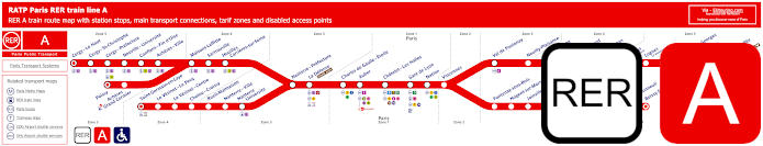
Red RER A train line map showing station stops, line branches, transport connections and zones
So here we have the RER A train line that has several branches going to various place within the Paris region of Ile de France, you will be pleased to know that you can catch this train from major transport hubs such as Paris Gare de Lyon and Chatelet Les Halles, with this latter stop being the closest to the Musee du Louvre at a distance of approximately 550 metres.
Paris RER A train line stops: Cergy le Haut*, Cergy Saint-Christophe, Cergy Prefecture, Neuville Universite, Conflans Fin d’Oise, Acheres Ville, Maisons-Laffitte, Sartrouville, Houilles - Carrieres sur Seine, Nanterre Prefecture, La Defense (Grande Arche), Charles de Gaulle Etoile, Auber, Chatelet Les Halles, Paris Gare de Lyon, Nation, Vincennes, Val de Fontenay, Neuilly Plaisance, Bry sur Marne, Noisy le Grand - Mont d’Est, Noisy Champs, Noisiel, Lognes, Torcy, Bussy Saint-Georges, Val d’Europe, Marne la Vallee - Chessy (Parcs Disneyland)*, Poissy*, Acheres - Grand Cormier, Saint-Germain en Laye*, Le Vesinet Le Pecq, Le Vesinet Centre, Chatou Croissy, Rueil Malmaison, Nanterre Ville, Nanterre University, Fontenay sous Bois, Nogent sur Marne, Joinville le Pont, Saint-Maur - Creteil, Le Parc de Saint-Maur, Champigny, La Varenne - Chennevieres, Sucy Bonneuil, Boissy Saint-Leger*.
* Terminus Points.
Paris RER A train line main transport connections:
Metro Lines: 1, 2, 3, 4, 6, 7, 8, 9, 11, 14. Train Lines: B, D, E, J, L, R, U, TGV. Tram Lines: T2, 13. Bus Lines: 393, RoissyBus, TVM (14).
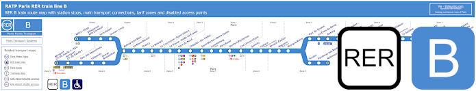
Blue RER B train line map showing station stops, line branches, transport connections and zones
Yet the RER B train line is one of the ways you choose for getting to Charles de Gaulle Airport directly with no changes from the centre of Paris via the Gare du Nord or Chatelet Les Halles, which like above, is also a train station for The Louvre and many other tourist attractions.
In fact, up until very recently, Chatelet-les-Halles was the largest underground station in the world serving 5 Metro lines and 3 regional train lines with more than 750,000 travellers each day, and above ground you can discover an enormous shopping mall, an indoor swimming pool and a 19 screen multiplex cinema, which is the largest in the Paris region.
Paris RER B train line stops:
Mitry–Claye*, Villeparisis - Mitry-le-Neuf, Vert-Galant, Sevran–Livry, Aulnay-sous-Bois, Le Blanc-Mesnil, Drancy, Le Bourget, La Courneuve - Aubervilliers, La Plaine - Stade de France, Gare du Nord, Chatelet - Les Halles, Saint-Michel - Notre-Dame, Luxembourg, Port-Royal, Denfert-Rochereau, Cite Universitaire, Gentilly, Laplace, Arcueil - Cachan, Bagneux, Bourg-la-Reine, Sceaux, Fontenay-aux-Roses, Robinson*, Aeroport Charles de Gaulle 2 - TGV*, Aeroport Charles de Gaulle 1, Parc des Expositions, Villepinte, Sevran - Beaudottes, Parc de Sceaux, La Croix de Berny, Antony (Orly), Fontaine-Michalon, Les Baconnets, Massy - Verrieres, Massy - Palaiseau, Palaiseau, Palaiseau - Villebon, Lozere (Ecole Polytechnique), Le Guichet, Orsay–Ville, Bures-sur-Yvette, La Hacquiniere, Gif-sur-Yvette, Courcelle-sur-Yvette, Saint-Remy-les-Chevreuse*.
* Terminus Points.
Paris RER B train line main transport connections:
Metro Lines: 1, 2, 4, 5, 6, 7, 10, 11, 14. Train Lines: A, C, D, E, H, K, TGV, CDG Val, OrlyVal. Tram Lines: T3a, T4, T11. Bus Lines: TVM (14), OrlyBus, RoissyBus.
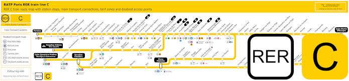
Yellow RER C train line map showing station stops, line branches, transport connections and zones
Whereas this shows the RER C train line that also has many different branches going from locations close to Paris tourist attractions like Champ de Mars - Tour Eiffel, Bibliotheque Francois Mitterrand and Musee d'Orsay, with this latter stop being on the opposite side of the River Seine by the museum that takes over for newer art collections from where the Musee du Louvre leaves off.
Paris RER C train line stops:
Pontoise*, St-Ouen l'Aumone, St-Ouen l'Aumone - Liesse, Pierrelaye, Montigny Beauchamp, Francoville - Le Plessis-Bouchard, Cernay, Ermont Eaubonne, St-Gratien, Epinay-sur-Seine, Gennevilliers, Les Gresillons, St-Ouen, Porte de Clichy, Pereire Levallois, Neuilly - Porte Maillot (Palais des Congres), Avenue Foch, Avenue Henri Martin, Boulainvilliers, Avenue du Pdt Kennedy (Maison de Radio France), Champ de Mars (Tour Eiffel), Pont d'Iena, Invalides, Musee d'Orsay, St-Michel (Notre Dame), Paris Gare d'Austerlitz, Bibliotheque Francois Mitterrand, Ivry-sur-Seine, Vitry-sur-Seine, Les Ardoines, Choisy le Roi, Villeneuve le Roi, Ablon, Athis Mons, Juvisy, Savigny-sur-Orge, Epinay-sur-Orge, Ste-Genevieve des Bois, St-Michel-sur Orge, Bretigny, Marolles en Hurepoix, Bouray, Lardy, Chamarande, Etrechy, Etampes, St-Martin d'Etampes*, Versailles Chateau Rive Gauche*, Porchefontaine, Viroflay Rive Gauche, Chaville - Velizy, Meudon - Val Fleury, Issy, Issy - Val de Seine, Pont du Garigliano (Hopital Europeen Georges Pompidou), Javel, St-Quentin en Yvelines*, St-Cyr, Versailles Chantiers**, Petit Jouy les Loges, Jouy en Josas, Vauboyen, Bievres, Igny, Massy Palaiseau**, Massy Verrieres, Chemin d'Antony, Rungis La Fraternelle, Pont de Rungis (Aeroport d'Orly), Orly Ville, Les Saules, Longjumeau, Chilly Mazarin, Gravigny Balizy, Petit Vaux, La Norville (St-Germain les Arpajon), Arpajon, Egly, Breuillet (Bruyeres le Chatel), St-Cheron, Sermaise, Dourdan, Dourdan la Foret*.
* Terminus Points. ** RER C Transfer Points.
Paris RER C train line main transport connections:
Metro Lines: 1, 2, 3, 4, 5, 6, 8, 9, 10, 12, 13, 14. Train Lines: B, D, H, J, N, U, TGV, TER. Tram Lines: T1, T2, T3a, T3b, T6, T7, T8, T9, T11, T13. Bus Lines: 183, 393, PC (98), TVM (14).
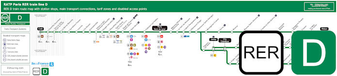
Green RER D train line map showing station stops, line branches, transport connections and zones
You will find that the RER D train line also has various branches travelling from Paris Gare du Nord, Gare de Lyon and Chatelet Les Halles, which is a way of getting to Stade de France and even the impressive Chateau de Chantilly via the Chantilly-Gouvieux station, but when it comes to The Louvre, you would need to the Chatelet Les Halles station.
Paris RER D train line stops:
Creil*, Chantilly - Gouvieux, Orry-la-Ville - Coye-la-Foret, La Borne Blanche, Survilliers - Fosses, Louvres, Les Noues, Goussainville, Villiers-le-Bel - Gonesse - Arnouville, Garges - Sarcelles, Pierrefitte - Stains, Saint-Denis, Stade de France - Saint-Denis, Paris Gare du Nord, Chatelet - Les-Halles, Paris Gare de Lyon, Maisons-Alfort - Alfortville, Le Vert de Maisons, Creteil - Pompadour, Villeneuve - Triage, Villeneuve - Saint-Georges, Montgeron-Crosne, Yerres, Brunoy, Boussy - Saint-Antoine, Combs-la-Ville - Quincy, Lieusaint-Moissy, Savigny-le-Temple - Nandy, Cesson, Le Mee-sur-Seine, Melun*, Vigneux-sur-Seine, Juvisy**, Viry Cahatillon**, Ris - Orangis, Grand-Bourg, Evry - Val de Seine, Grigny Centre, Orangis - Bois de l'Epine, Evry - Courcouronnes (Centre), Le Bras de Fer (Evry Genepole), Corbeil - Essonnes**, Essonnes - Robinson, Villabe, Le Plessis - Chenet, Le Coudray - Montceaux, Saint-Fargeau, Ponthierry - Pringy, Poissise-le-Roi, Vosves, Melun**, Moulin Galant, Mennecy, Ballancourt, La Ferte-Alais, Boutigny, Maisse, Buno Gironville, Boigneville, Malesherbes*.
* Terminus points. ** RER D Transfer points.
Paris RER D train line main transport connections:
Metro Lines: 1, 2, 4, 5, 7, 11, 14. Train Lines: A, B, C, E, H, K, P, R, TGV, TER. Tram Lines: T1, T5, T8, T11. Bus Lines: 20, 393, Senlis, TVM (14), Tzen 1.
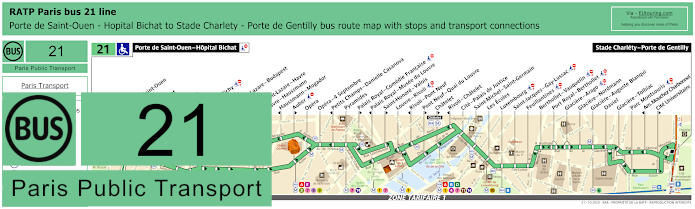
RATP Paris bus line 21 with stops, connections and street plan
Yet here we have the RATP bus line 21 that travels between Porte de Saint-Ouen - Hopital Bichat and Stade Charlety - Porte de Gentilly, which has numerous bus stops on route, although as you can see from the maps, some of the stops are only served in a particular direction like Palais Royal - Comedie Francaise and Palais Royal - Musee du Louvre, yet the Louvre - Rivoli bus stop is also very convenient right by the Cour Carree courtyard.
Paris bus line 21 stops:
Porte de Saint-Ouen - Hopital Bichat, Porte de Saint-Ouen, Navier, Guy Moquet, Davy, La Fourche, Ganneron, Place de Clichy, Liege, Gare Saint-Lazare - Budapest**, Trinite*, Gare Saint-Lazare - Havre**, Havre - Haussmann**, Haussmann - Mogador*, Auber**, Opera, Opera - 4 Septembre, Petits Champs - Danielle Casanova*, Pyramides, Palais Royal - Comedie Francaise**, Palais Royal - Musee du Louvre*, Saint-Honore - Valois**, Louvre - Rivoli, Rivoli - Pont Neuf*, Pont Neuf - Quai du Louvre**, Chatelet**, Rivoli - Chatelet*, Cite - Palais de Justice, Saint-Michel - Saint-Germain, Les Ecoles, Luxembourg, Saint-Jacques - Gay-Lussac, Feuillantines, Berthollet - Vauquelin, Port Royal - Berthollet, Glaciere - Arago, Glaciere - Nordmann, Glaciere - Auguste Blanqui, Daviel, Glaciere - Tolbiac, Parc Montsouris, Am. Mouchez Charbonnel*, Cite Universitaire**, Stade Charlety - Porte de Gentilly.
* Stop served in direction of Porte de Saint-Ouen - Hopital Bichat. ** Stop served in direction of Stade Charlety - Porte de Gentilly.
Paris bus line 21 main transport connections:
Metro Lines: 1, 2, 3, 4, 6, 7, 8, 9, 10, 11, 12, 13, 14. Train Lines: A, B, D, E, J, L. Tram Lines: T3a, T3b.
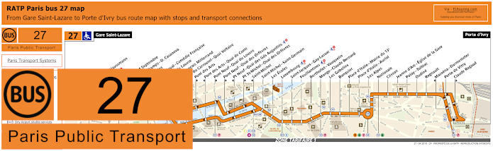
RATP Paris bus line 27 with stops, connections and street plan
Whereas the bus line 27 goes from Porte d'Ivry to Gare Saint-Lazare train station, yet by looking at the street maps and timetables, you will see there are numerous bus stops on route but some are only served in a particular direction just like the Musee du Louvre stop located by the Arc de Triomphe du Carrousel between Tuileries gardens and the Louvre courtyard with the famous pyramid.
Paris bus line 27 stops:
Gare Saint-Lazare, Havre - Haussmann, Auber, Opera, Opera - 4 Septembre, Petits Champs - D. Casanova*, Pyramides, Palais-Royal - Comedie Francaise, Musee du Louvre*, Quai Francois Mitterrand**, Pont du Carrousel - Quai Voltaire*, Pont des Arts**, Pont des Arts - Quai de Conti*, Pont Neuf - Quai du Louvre**, Pont Neuf - Quai des Orfevres**, Pt Neuf - Quai des Gds Augustins*, Pt St-Michel - Quai des Orfevres**, Saint-Michel*, Saint-Michel - Saint-Germain, Les Ecoles, Luxembourg, Saint-Jacques - Gay-Lussac, Feuillantines, Berthollet - Vauquelin, Monge - Claude Bernard, Les Gobelins, Banquier, Place d’Italie - Mairie du 13e, Place d’Italie - Auriol, Les Alpes, Nationale, Clisson, Jeanne d’Arc - Eglise de la Gare, Patay - Tolbiac, Oudine, Regnault, Massena - Darmesteter*, Porte de Vitry, Claude Regaud**, Porte d'Ivry.
* Stop served in direction of Gare Saint-Lazare. ** Stop served in direction of Porte d'Ivry.
Paris bus line 27 main transport connections:
Metro Lines: 1, 3, 4, 5, 6, 7, 8, 9, 12, 13, 14. Train Lines: A, B, C, E, L, J. Tram Line: T3a.
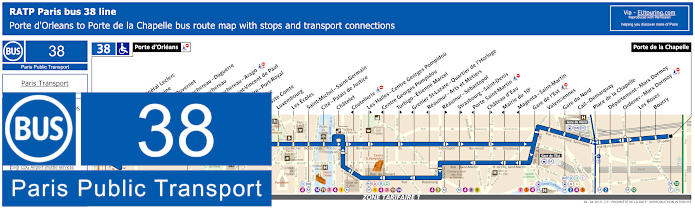
RATP Paris bus line 38 with stops, connections and street plan
Here you can see the maps and timetables for the RATP bus line 38 travelling between Porte d'Orleans and Porte de la Chapelle, which has numerous bus stops and transport connections on route, yet for getting to The Louvre and its impressive museum you would need the bus stop Chatelet, which is around a 500 to 600 metres walk away.
Paris bus line 38 stops:
Porte d'Orleans, Alesia - General Leclerc, Alesia - Maine*, Mouton - Duvernet, Denfert-Rochereau - Daguerre**, Denfert-Rochereau*, Denfert-Rochereau - Arago, Hopital Saint-Vincent de Paul, Observatoire - Port-Royal, Val de Grace, Auguste Comte, Luxembourg, Les Ecoles, Saint-Michel - Saint-Germain, Cite - Palais de Justice, Chatelet, Coutellerie*, Les Halles - Centre Georges Pompidou**, Centre Georges Pompidou*, Turbigo - Etienne Marcel**, Grenier St-Lazare - Quartier de l’Horloge*, Reaumur - Arts et Metiers*, Reaumur - Sebastopol**, Strasbourg - Saint-Denis**, Porte Saint-Martin*, Chateau d’Eau**, Mairie du 10e*, Magenta - Saint-Martin*, Gare de l’Est, Valenciennes, Gare du Nord, Cail-Demarquay, Place de la Chapelle, Departement-Marx Dormoy, Ordener - Marx Dormoy, Les Roses, Boucry, Porte de la Chapelle.
*Stops served in direction of Porte d'Orleans. ** Stops served in direction of Porte de la Chapelle.
Paris bus line 38 main transport connections:
Merto Lines: 1, 2, 3, 4, 5, 6, 7, 8, 9, 11, 12, 14. Train Lines: A, B, C, D, E, H, K, P. Tram Lines: T3a, T3b.
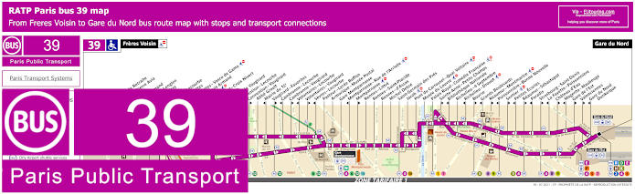
RATP Paris bus line 39 with stops, connections and street plan
Although, this is the bus line 39 run by RATP that goes from the very outskirts of Paris with the terminus of Freres Voisin, going through to Gare du Nord train station, which has numerous bus stops on its route including the Musee du Louvre bus stop, which is one of the closest bus stops to The Louvre, however, as you can see from the maps, there are numerous bus stops that only go in a specific direction.
Paris bus line 39 stops:
Freres Voisin, Maison de Retraite**, Colonel Pierre Avia*, Severine**, Louis Armand*, Suzanne Lenglen*, Porte d’Issy**, Balard*, Balard - Lecourbe*, Desnouettes**, Desnouettes - Vasco de Gama**, Lycee Louis Armand*, Hameau**, Duranton**, Hopital de Vaugirard**, Convention - Lecourbe*, Convention - Vaugirard**, Abbe Groult, Mairie du 15e*, Vaugirard - Favorites**, Cambronne - Lecourbe*, Cambronne - Vaugirard**, Volontaires - Lecourbe*, Volontaires - Vaugirard**, Sevres - Lecourbe*, Pasteur - Lycee Buffon, Armorique - Musee Postal, Gare Montparnasse, Montparnasse - Rue de l’Arrivee*, Montparnasse**, Rennes - Littre, Rennes - Saint-Placide, Rennes - d’Assas, Michel Debre, Saint-Germain des Pres, Jacob, Pont du Carrousel - Quai Voltaire, Musee du Louvre, Palais Royal - Comedie Francaise, Sainte-Anne - Petits Champs**, Bibliotheque Nationale*, Richelieu - 4 Septembre, Richelieu - Drouot*, Bourse**, Grands Boulevards*, Reaumur - Montmartre**, Poissonniere - Bonne Nouvelle*, Sentier**, Petites Ecuries*, Reaumur - Sebastopol**, Paradis*, Strasbourg - Saint-Denis**, La Fayette - Poissonniere*, Chateau d'Eau**, Magenta - Maubeuge*, Gare de l'Est**, Valenciennes**, Gare du Nord - Dunkerque*, Gare du Nord.
* Served in the direction of Freres Voisin ** Served in the direction of Gare du Nord
Paris bus line 39 main transport connections:
Metro lines: 1, 2, 3, 4, 5, 6, 7, 8, 9, 10, 12, 13. Train lines: B, D, E, H, K, N, P. Tram lines: T2, T3a.
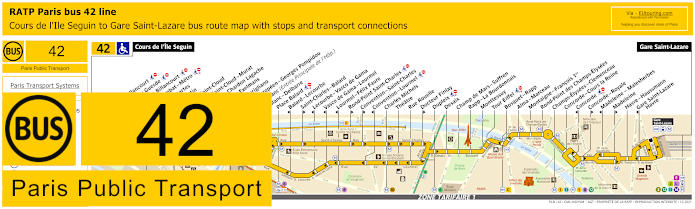
RATP Paris bus line 42 with stops, connections and street plan
Travelling from Cours de l'Ile Seguin to Gare Saint-Lazare train station you will find that the bus line 42 has a route covering many Paris tourist attractions and for the Musee du Louvre you would need the Concorde stop at the Place de la Concorde, then take a relaxing walk through the Tuileries Gardens or along the Rue de Rivoli, at a distance of around 1200 to 1400 metres depending upon the route you take.
Paris bus line 42 stops:
Cours de l'Ile Seguin, Parch de Billancourt, Place Jules Guesde, Marche de Billancourt, Marcel Sembat - Metro, Rene Descartes, Henri Martin, Porte de Saint-Cloud, Porte de Saint-Cloud-Murat, Versailles - Chardon Lagache, Versailles Exelmans, Pont du Garigliano, Hopital Europeen - Georges Pompidou, Rue Leblanc (Entree Principale de l'Hop.), Leblanc - Delbarre**, Place Balard, Balard - Lecourbe*, Saint-Charles - Balard**, Lecourbe - Vasco de Gama*, Vasco de Gama - Lourmel*, Lourmel - Felix Faure*, Rond-Point Saint-Charles**, Convention - Saint-Charles**, Convention - Lourmel*, Charles Michels, Theatre, Rue Rouelle, Docteur Finlay**, Dupleix, Desaix, Champ de Mars - Suffren, Rapp - La Bourdonnais, Monttessuy, Tour Eiffel, Bosquet - Rapp, Alma - Marceau, Montaigne - Francois 1er, Rond-Point des Champs-Elysees, Champs-Elysees - Clemenceau, Concorde - Cours la Reine, Concorde*, Concorde - Royale**, Madeleine - Malesherbes*, Madeleine*, Havre - Haussmann, Gare Saint-Lazare - Havre*, Gare Saint-Lazare.
* Stop served in the direction of Cours de l'Ile Seguin. ** Stop served in the direction of Gare Saint-Lazare.
Paris bus line 42 main transport connections:
Metro Lines: 1, 3, 6, 8, 9, 10, 12, 13, 14. Train Lines: C, E, J, L. Tram Line: T3a.
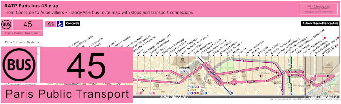
RATP Paris bus line 45 with stops, connections and street plan
Then you have the RATP Paris bus line 45 that actually starts from Concorde, which like above, is the bus stop you would need for the Musee du Louvre and the route travels through to Aubervilliers - France-Asie on the outskirts of Paris in ticket tariff zone 2 as you can see from the route maps and timetables, and there are also numerous transport connections on route as well, including to Gare du Nord train station where Eurostar arrives.
Paris bus line 45 stops:
Concorde, Concorde - Royale**, Madeleine - Malesherbes*, Madeleine, Capucines - Caumartin, Opera - Scribe*, Opera**, Chaussee d'Antin, Saint-Georges - Provence**, Le Peletier**, Le Peletier - Haussmann*, Carrefour de Chateaudun*, Chateaudun - Lamartine*, Cadet**, Maubeuge - Rochechouart*, Square Montholon**, Condorcet*, Magenta - Maubeuge*, Place Franz Liszt**, La Fayette - Magenta**, Gare du Nord - Dunkerque*, Gare du Nord, Cail - Demarquay, Place de la Chapelle, Philippe de Girard**, Chapelle - Caillie*, Chateau Landon**, Place du Maroc**, Maroc*, Riquet*, Curial - Archereau**, Mathis**, Radiguet*, Curial - Crimee**, Crimee - Rosa Parks**, Crimee - Aubervilliers*, Evangile - Aubervilliers, Porte d'Aubervilliers - Macdonald, Skanderbeg, Parc du Millenaire, Jardin des Berges, Rue de La Hale Coq*, Quai Lucien - Lefranc**, Aubervilliers - France-Asie.
* Stop served in the direction of Concorde. ** Stop served in the direction of Aubervilliers - France-Asie.
Paris bus line 45 main transport connections:
Metro Lines: 1, 2, 3, 4, 5, 7, 8, 9, 12, 14. Train Lines: A, B, D, E, H, K. Tram Line: T3b.
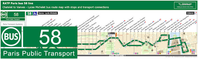
RATP Paris bus line 58 with stops, connections and street plan
Whereas the RATP Paris bus line 58 travels from Vanves - Lycee Michelet to Chatelet with many bus stops in between, although we would like to point out that many are direction dependant just like Pont Neuf - Quai du Louvre for how to get to Musee du Louvre, so you could need a stop on the Ile de la Cite or on the opposite side of the River Seine.
Paris bus line 58 stops:
Vanves - Lycee Michelet, Carrefour Albert Legris***, Jean Jaures - Jean Bleuzen, Adolphe Pinard**, Pont de la Vallee, Porte de Vanves, Porte Didot - Lycee Raspail*, Porte de Chatillon*, Colonel Monteil**, Didot**, Jean Moulin*, Hopitaux Broussais et Saint-Joseph**, Hopital Notre-Dame de Bon Secours*, Alesia - Didot**, Alesia - Les Plantes*, Pernety**, Rue Benard*, Chateau**, Chateau - Mairie du 14e*, Losserand - Maine, Gaite***, Gare Montparnasse***, Montparnasse - Rue du Depart, Montparnasse - Cinemas*, Vavin, Brea - Notre-Dame-des-Champs*, Notre-Dame-des-Champs**, Raspail - Fleurus**, Fleurus**, Guynemer - Vavin* ***, Musee du Luxembourg***, Senat, Theatre de l'Odeon* ***, Saint-Germain - Odeon***, Mazarine*, Saint-Andre des Arts** ***, Pont Neuf - Quai des Gds Augustins, Saint-Michel**, Cite - Palais de Justice*, Pont Neuf - Quai du Louvre**, Chatelet - Q. de Gesvres**, Chatelet.
* Stop served in the direction of Vanves - Lycee Michelet. ** Stop served in the direction of Chatelet. *** Not accessible to those with reduced mobility.
Paris bus line 58 main transport connections:
Metro Lines: 1, 4, 6, 7, 10, 11, 12, 13, 14. Train Lines: A, B, C, D, N. Tram Line: T3a.
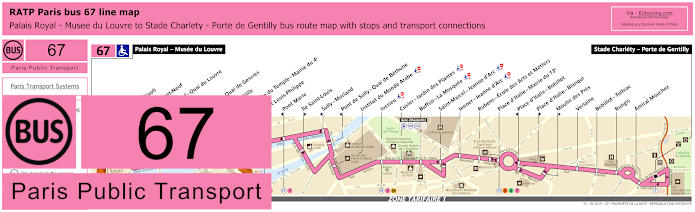
RATP Paris bus 67 map with stops, connections and street plan
Yet the bus line 67 actually starts at Palais Royal - Musee du Louvre going through to Stade Charlety - Porte de Gentilly and several bus stops on route go to tourist attractions including the Hotel du Ville and Institut du Monde Arabe, but this bus route is also an option for how to get to Jardin des Plantes with its menagerie zoo and natural history museum from the world famous Louvre Museum.
Paris bus line 67 stops:
Palais Royal - Musee du Louvre, Louvre - Rivoli, Rivoli - Pont-Neuf, Pont Neuf - Quai du Louvre, Chatelet, Chatelet - Quai de Gesvres, Hotel de Ville, Rue Vieille du Temple - Mairie du 4e, Pont Louis-Philippe, Pont Marie, Ile Saint-Louis, Sully - Morland, Pont de Sully - Quai de Bethune, Institut du Monde Arabe, Jussieu, Cuvier - Jardin des Plantes, Buffon - La Mosquee, Saint-Marcel - Jeanne d’Arc, Jenner - Jeanne d’Arc, Rubens - Ecole des Arts et Metiers, Place d’Italie - Mairie du 13e, Place d’Italie - Bobillot, Place d’Italie - Blanqui, Moulin des Pres, Verlaine, Bobillot - Tolbiac, Rungis, Amiral Mouchez, Stade Charlety - Porte de Gentilly.
Paris bus line 67 main transport connections:
Metro Lines: 1, 4, 5, 6, 7, 10, 11, 14. Train Lines: A, B, D. Tram Line: T3a.
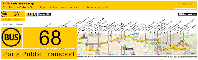
RATP Paris bus line 68 with stops, connections and street plan
However, this shows the street maps and timetables for RATP bus line 68 travelling from Place de Clichy to Chatillon - Montrouge, which has transport connections on route at places such as Gare Montparnasse train station, and for The Louvre you could opt to alight at the bus stops Palais Royal - Comedie Francaise, Pyramides - Saint-Honore or the Musee du Louvre stop in between Arc de Triomphe du Carrousel and the pyramid main entrance, although the stop depends on your direction of travel.
Paris bus line 68 stops:
Place de Clichy, Blanche**, Blanche - Calais**, Liege*, Moncey**, Trinite, Chaussee d'Antin**, Haussmann - Mogador*, Opera - Scribe**, Opera*, Opera - Quatre Septembre, Petits Champs - Danielle Casanova*, Pyramides, Palais Royal - Comedie Francaise**, Pyramides - Saint-Honore*, Musee du Louvre, Pont du Carrousel - Quai Voltaire**, Henry de Montherlant**, Pont Royal - Quai Voltaire*, Musee d'Orsay**, Solferino - Bellechasse**, Rue du Bac - Rene Char, Charlotte Perriand, Sevres - Babylone, Rue du Cherche-Midi*, Rennes - Raspail, Notre-Dame-des-Champs, Vavin, Raspail - Edgar Quinet, Victor Considerant, Denfert-Rochereau, Mouton-Duvernet, Alesia - Maine**, Alesia - General Leclerc, Porte d'Orleans, Porte d'Orleans - Ernest Reyer, Cimetiere de Montrouge*, Gabrielle de Guerchy**, Mairie de Montrouge, Radiguey**, Peri - Arnoux**, Verdier - Republique*, Verdier - Guillot*, Jean Jaures, Jean Jaures - Stade Multisports**, Jules Guesde, Jean Monnet*, Maurice Arnoux**, Chatillon - Montrouge.
* Stop served in direction of Place de Clichy. ** Stop served in direction of Chatillon - Montrouge.
Paris bus line 68 main transport connections:
Metro Lines: 1, 2, 3, 4, 6, 7, 9, 10, 12, 13, 14. Train Lines: A, B, C. Tram Lines: T3a, T6.
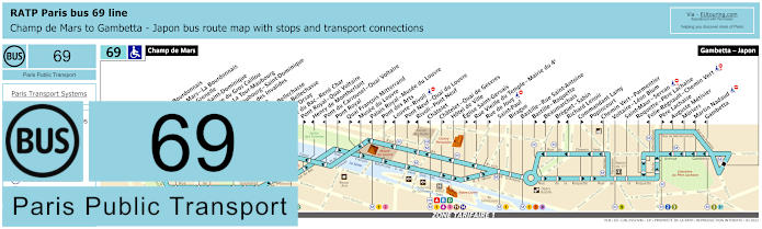
RATP Paris bus line 69 with stops, connections and street plan
Many of the Paris bus routes have stops only served in a particular direction, so when you are thinking about getting to The Louvre, this is the same scenario, just like bus line 69 that has a stop Quai Francois Mitterrand going in the direction of Gambetta - Japon terminus and the Musee du Louvre bus stop going in the direction of Champ de Mars terminus, which is also an option for how to get to Eiffel Tower from Louvre Museum.
Paris bus line 69 stops:
Champ de Mars, Rapp - La Bourdonnais, Champ de Mars - La Bourdonnais*, Bosquet - Grenelle*, Bosquet - Saint-Dominique**, Saint-Pierre du Gros Caillou, Invalides - La Tour-Maubourg*, La Tour-Maubourg - Saint-Dominique**, Esplanade des Invalides, Bourgogne, Grenelle - Bellechasse*, Solferino - Bellechasse, Musee d’Orsay*, Rue du Bac - Rene Char, Pont Royal - Quai Voltaire**, Henry de Montherlant*, Pont du Carrousel - Quai Voltaire*, Pont Royal**, Quai Francois Mitterrand**, Musee du Louvre*, Palais Royal - Musee du Louvre*, Pont des Arts**, Louvre - Rivoli* ***, Pont Neuf - Quai du Louvre**, Rivoli - Pont Neuf*, Chatelet*, Chatelet - Quai de Gesvres**, Hotel de Ville, Eglise Saint-Gervais**, Rue Vieille du Temple - Mairie du 4e*, Rue de Jouy** ***, Saint-Paul, Birague, Bastille - Rue Saint-Antoine, Bastille - Roquette**, Beaumarchais*, Breguet - Sabin**, Richard Lenoir*, Commandant Lamy**, Popincourt, Chemin Vert - Parmentier*, Voltaire - Leon Blum, Saint-Maur - Servan***, Roquette - Pere Lachaise, Folie-Regnault - Chemin Vert* ***, Pere Lachaise**, Auguste Metivier*, Muriers, Martin Nadaud***, Gambetta, Gambetta - Japon.
* Stop served in direction of Champ de Mars. ** Stop served in direction of Gambetta - Japon. *** Not accessible to those with reduced mobility.
Paris bus line 69 main transport connections:
Metro Lines: 1, 2, 3, 3bis, 4, 5, 7, 8, 9, 11, 12, 13, 14. Train Lines: A, B, C, D.
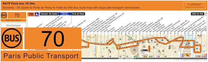
RATP Paris bus line 70 with stops, connections and route plan
Additionally, the Paris bus line 70 also has stops only served in a particular direction, yet travelling from Hotel de Ville, as you will see from the maps and timetables, there is a terminus of Porte de Passy, but the bus route goes further to Suresnes de Gaulle on a Monday to Friday, which is how to get to Hippodrome de Longchamp, but for the fabulous Louvre Museum you would need the Pont Neuf - Quai du Louvre bus stop.
Paris bus line 70 stops:
Suresnes - De Gaulle***, Mairie de Suresnes** ***, Henri IV** ***, Henri Sellier - Pont de Suresnes** ***, Rue des Bourets - Pont de Suresnes* ***, Pont de Suresnes** ***, Les Moulins - Camping***, Allee de l'Esperance***, Les Cascades***, Porte de Passy, Louis Boilly**, Avenue Ingres*, Chaussee de la Muette, Ranelagh*, Rodin*, Les Vignes - Boulainvilliers RER**, Assomption - Radio France**, La Fontaine - Radio France*, Place du Docteur Hayem - Radio France, Pont de Grenelle - Maurice Bourdet, Pont de Grenelle - Place Fernand Forest, Charles Michels, Violet, Felix Faure, Peclet, Mairie du 15e, Vaugirard - Favorites**, Cambronne - Lecourbe*, Cambronne - Vaugirard**, Volontaires - Lecourbe*, Volontaires - Vaugirard**, Sevres - Lecourbe, Pasteur - Lycee Buffon**, Hopital des Enfants Malades, Vaneau - Saint-Romain, Bac - Saint-Placide, Sevres - Babylone, Michel Debre, Eglise Saint-Sulpice*, Bonaparte - Saint-Germain**, Seine - Buci**, Saint-Germain - Odeon*, Saint Andre des Arts**, Mazarine*, Pont Neuf - Quai des Grands Augustins, Saint-Michel, Cite - Palais de Justice, Pt Neuf - Q du Louvre, Chatelet - Quai des Gesvres**, Chatelet*, Hotel de Ville.
* Served in Direction of Suresnes - De Gaulle or Porte de Passy. ** Served in direction of Paris Hotel de Ville. *** Only served on a Monday to Friday.
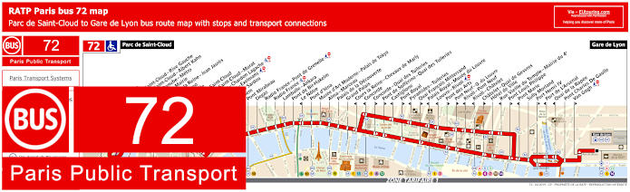
RATP Paris bus 72 map with stops, connections and street plan
You will find the RATP bus 72 has a route travelling from Parc de Saint-Cloud to Gare de Lyon train station and with its many bus stops and transport connections like at Pont d'Iena, Rivoli - Chatelet, etc you will see that there are direction dependant stops for The Louvre including Palais Royal - Musee du Louvre and Louvre - Rivoli, both of which are also Metro stations.
Paris bus line 72 stops:
Parc de Saint-Cloud, La Colline, Pont de Saint-Cloud - Rive Gauche, Pont de Saint-Cloud - Albert Kahn, Rhin et Danube - Metro, Ancienne Mairie, Route de la Reine - Jean Jaures, Victor Hugo, La Tourelle, Porte de Saint-Cloud, Porte de Saint-Cloud - Murat, Versailles - Chardon Lagache, Versailles - Exelmans, Victorien Sardou, Wilhem, Pont Mirabeau, Degas, Radio France - Pont de Grenelle, Radio France, Lamballe - Ankara, Pont de Bir-Hakeim, Le Notre*, Pont d’Iena, Musee d’Art Moderne - Palais de Tokyo, Alma - Marceau, Palais de la Decouverte, Grand Palais, Cours la Reine - Chevaux de Marly*, Concorde*, Concorde - Quai des Tuileries**, Pont de Solferino - Quai des Tuileries**, Castiglione*, Pont Royal**, Pyramides - Tuileries*, Quai Francois Mitterrand**, Palais Royal - Musee du Louvre*, Louvre - Rivoli*, Pont des Arts**, Pont Neuf - Quai du Louvre**, Rivoli - Pont Neuf*, Rivoli - Chatelet*, Chatelet - Quai de Gesvres**, Hotel de Ville, Rue Vieille du Temple - Mairie du 4e*, Pont Louis Philippe**, Pont Marie*, Sully Morland, Port Henri IV**, Port de L'Arsenal*, Quai de la Rapee*, Pont Charles De Gaulle, Van Gogh**, Gare de Lyon.
* Served in direction of Parc de Saint-Cloud. ** Served in direction of Gare de Lyon.
Paris bus line 72 main transport connections:
Metro Lines: 1, 4, 5, 6, 7, 8, 9, 10, 11, 12, 13, 14. Train Lines: A, B, C, D, R.
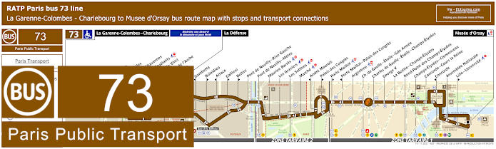
RATP Paris bus line 73 with stops, connections and street plan
Although the Paris bus line 73 travels from Musee d'Orsay to La Garenne-Colombes - Charlebourg or just to La Defense depending upon the day as you can see from the maps and timetables, and this is one of the ways for how to get to Palais des Congres but also the Musee du Louvre by utilising the bus stop Concorde or Concorde - Cours la Reine depending upon your direction of travel.
Paris bus line 73 stops:
La Garenne-Colombes - Charlebourg***, Nordmann***, Les Fauvelles***, Puvis de Chavannes***, Rue des Etudiants***, Leonardo de Vinci***, Faubourg de l’Arche** ***, Caron***, La Defense, Gambetta*, Boieldieu**, Alsace*, Gallieni**, Bellini**, Pont de Neuilly - Rive Gauche, Pont de Neuilly, Les Graviers, Rue de l’Hotel de Ville, Les Sablons, Marche, Montrosier*, Andre Maurois**, Palais des Congres**, Porte Maillot**, Porte Maillot - Palais des Congres*, Argentine, Charles de Gaulle - Etoile - Gde Armee, Charles de Gaulle - Etoile - Champs-Elysees, George V, La Boetie - Champs-Elysees, Rond-Point des Champs-Elysees, Champs-Elysees - Clemenceau, Concorde - Cours la Reine, Concorde*, Assemblee Nationale, Lille - Universite**, Musee d'Orsay.
* Stop served in direction of La Garenne-Colombes - Charlebourg or La Defense. ** Stop served in direction of Musee d'Orsay. *** Not served on a Sunday or French holidays.
Paris bus line 73 main transport connections:
Metro Lines: 1, 2, 6, 8, 9, 12, 13. Train Lines: A, C, L, U. Tram Line: T2.
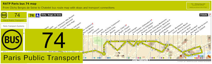
RATP Paris bus line 74 with stops, connections and street plan
Whereas this shows the street maps and timetables for bus line 74 that goes from Clichy - Berges de Seine in tariff zone 2 through to Chatelet transport hub in Paris tariff zone 1, and as you can see this has a bus stop called Louvre - Rivoli that will get you to the famous Musee du Louvre.
Paris bus line 74 stops:
Clichy - Berges de Seine, Claude Debusy**, Hopital Beaujon, General Leclerc - Villeneuve - Hop. Beaujon, Republique - Francois Mitterrand, General Leclerc - Victor Hugo, Curton, Victor Hugo - Jean Jaures, Porte de Clichy, Boulay, Brochant - Cardinet, Rue des Moines*, Legendre, La Fourche, Ganneron, Place de Clichy - Caulaincourt*, Place de Clichy**, Blanche, Blanche - Calais**, Pigalle - Chaptal*, La Bruyere**, Saint-Georges, Saint-Georges - Chateaudun**, Carrefour de Chateaudun, Provence - Drouot**, Provence - Faubourg Montmartre*, Richelieu - Drouot - Mairie du 9e**, Richelieu - 4 Septembre**, Grands Boulevards*, Bourse**, Reaumur - Montmartre, Louvre - Etienne Marcel, Bourse de Commerce, Louvre - Rivoli, Rivoli - Pont Neuf*, Pont Neuf - Quai du Louvre**, Rivoli - Chatelet*, Chatelet.
* Stop served in direction of Clichy - Berges de Seine. ** Stop served in direction of Chatelet.
Paris bus line 74 main transport connections:
Metro Lines: 1, 2, 3, 4, 7, 8, 9, 11, 12, 13, 14. Train Lines: A, B, C, D. Tram Line: T3b.
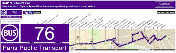
RATP Paris bus line 76 with stops, connections and street plan
So the maps and timetables for bus line 76 shows the route travelling from Bagnolet - Louise Michel through to Chatelet, and it is this terminus point at Place du Chatelet by the historical Tour St Jacques tower that you would need for getting to the Louvre Museum, which is a distance of around 850 metres away.
Paris bus line 76 stops:
Chatelet, Hotel de Ville, Eglise Saint-Gervais, R. Vieille du Temple - Mairie du 4e, Rue de Jouy, Saint-Paul, Birague, Bastille - Rue Saint-Antoine, Bastille - Faubourg Saint-Antoine, La Boule Blanche, Ledru-Rollin - Faubourg Saint-Antoine, Charonne - Keller, Faidherbe, Charonne - Voltaire, Charonne - Philippe Auguste, Charonne - Bagnolet, La Reunion, Pyrenees - Bagnolet, Pelleport - Bagnolet, Porte de Bagnolet, Echangeur de Bagnolet, General de Gaulle, Gallieni - Metro, Centre de Sante, La Poste, Mairie de Bagnolet, Marie-Anne Colombier, Eglise de Bagnolet, Pierre Curie, Descartes, Les Malassis, Stalingrad, Girardot, Bagnolet - Louise Michel.
Paris bus line 76 main transport connections:
Metro Lines: 1, 2, 3, 4, 5, 7, 8, 9, 11, 14. Train Lines: A, B, D. Tram Line: T3b.
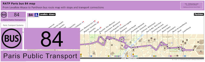
RATP Paris bus line 84 with stops, connections and street plan
Yet the RATP bus line 84 run by RATP goes from Levallois - Alsace in the ticket tariff zone 2 going into central Paris stopping at many tourist attractions on route where you could alight at the Concorde - Royale bus stop or the Assemblee Nationale stop for The Louvre, and as you can see from the maps and timetables, this bus route finishes at The Pantheon.
Paris bus line 84 stops:
Levallois - Alsace, Centre Commercial*, Reims - Hotel des Impots**, Wilson - Courcelles*, Reims - Pitet**, Porte de Courcelles, Pereire - Le Chatelier**, Pereire*, Pereire - Marechal Juin, Wagram - Courcelles, Courcelles, Murillo, Ruysdael - Parc Monceau**, Haussmann - Miromesnil, Saint-Augustin, Anjou - Chauveau Lagarde, Madeleine, Concorde - Royale, Assemblee Nationale, Lille -Universite, Solferino - Bellechasse, Rue du Bac - Rene Char, Charlotte Perriand, Sevres - Babylone, Michel Debre, Saint-Sulpice, Musee du Luxembourg, Senat, Luxembourg, Pantheon.
* Stop served in the direction of Levallois - Alsace. ** Stop served in the direction of Pantheon.
Paris bus line 84 main transport connections:
Metro Lines: 1, 2, 3, 4, 8, 9, 10, 12, 13, 14. Train Lines: B, C.
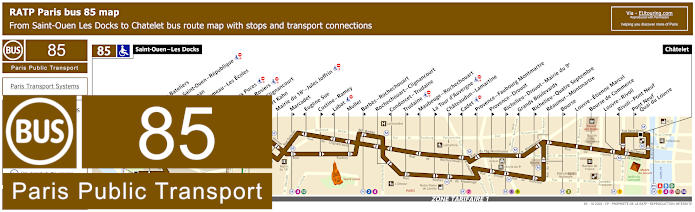
RATP Paris bus line 85 with stops, connections and street plan
However, here you can see the bus line 85 with its route map and timetables, which is also run by the transport company RATP and travels between Saint-Ouen - Les Docks and Chatelet with the nearest bus stop to the Musee du Louvre being the Louvre - Rivoli stop that is located by the Louvre Cour Carree courtyard for travel in one direction and by the Rue de Rivoli for the opposite way, both being only a matter of a few metres from the entrance.
Paris bus line 85 stops:
Saint-Ouen - Les Docks, Parvis des Bateliers, Mairie de Saint-Ouen - Republique, Ernest Renan, Eugene Lumeau - Les Ecoles, Paul Bert, Marche aux Puces, Michelet - Rosiers, Porte de Clignancourt, Albert Kahn, Mairie du 18e - Jules Joffrin, Marcadet**, Eugene Sue*, Custine - Ramey**, Labat*, Muller, Barbes - Rochechouart**, Rochechouart - Clignancourt, Condorcet - Trudaine*, Trudaine**, Maubeuge - Rochechouart*, La Tour d’Auvergne**, Chateaudun - Lamartine**, Cadet*, Provence - Faubourg Montmartre*, Provence - Drouot**, Richelieu - Drouot - Mairie du 9e**, Grands Boulevards*, Richelieu - Quatre Septembre**, Reaumur - Montmartre, Bourse**, Louvre - Etienne Marcel, Bourse de Commerce, Louvre - Rivoli, Rivoli - Pont Neuf*, Pont Neuf - Quai du Louvre**, Chatelet.
* Stop served in direction of Saint-Ouen - Les Docks. ** Stop served in direction of Chatelet, Paris.
Paris bus line 85 main transport connections:
Metro Lines: 1, 2, 3, 4, 7, 8, 9, 11, 12, 13, 14. Train Lines: A, B, D. Tram Line: T3b.
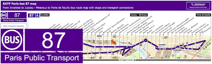
RATP Paris bus 87 map with stops, connections and street plan
Although the Paris bus line 87 going from Porte de Reuilly through to Invalides, has a major stop on route of Jussieu - Mineraux, yet this is one of the transport options for Bastille and Opera Bastille, not forgetting the Louvre Museum by utilising the Pont des Arts - Quai de Conti or the Pont du Carrousel - Quai Voltaire bus stops, even though these can only be utilised travelling in a certain direction, otherwise you would require to walk quite a bit further to utilise stops such as the Assemblee Nationale.
Paris bus line 87 stops:
Invalides, Pont de la Concorde*, Assemblee Nationale, Lille-Universite**, Solferino - Bellechasse**, Henry de Montherlant*, Rue du Bac - Rene Char**, Saint-Guillaume**, Pont du Carrousel - Quai Voltaire*, Pont des Arts - Quai de Conti*, Saint-Germain-des-Pres**, Pont Neuf - Quai des Grands Augustins*, Seine - Buci**, Saint-Germain - Odeon**, Saint-Michel*, Cluny**, Notre-Dame - Quai de Montebello*, Dante**, Maubert - Mutualite**, Pont de l'Archeveche*, Saint-Germain - Cardinal Lemoine**, Jussieu - Mineraux, Pont de la Tournelle - Cardinal Lemoine*, Institut du Monde Arabe**, Pont Sully - Quai de Bethune, Sully - Morland, Bastille - Henri IV, Bastille, Lyon - Ledru-Rollin, Gare de Lyon - Diderot, Gare de Lyon - Van Gogh**, Gare de Lyon*, Gare de Lyon - Maison de la RATP**, Min. de l'Economie et des Finances, Gare de Bercy, Dugommier, Charenton - Wattignies, Nicolai, Charenton - Jardiniers**, Wattignies - Gravelle*, Porte de Charenton**, Porte de Reuilly.
* Bus stop served in direction of Invalides. ** Bus stop served in direction of Porte de Reuilly.
Paris bus line 87 main transport connections:
Metro Lines: 1, 4, 5, 6, 7, 8, 10, 12, 13, 14. Train Lines: A, B, C, D, R. Tram Line: T3a.
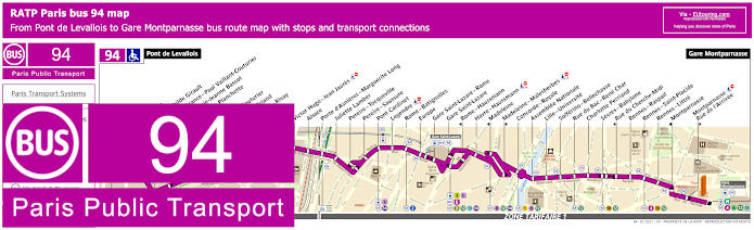
RATP Paris bus line 94 with stops, connections and street plan
To get to The Louvre via the Paris bus line 94 you would need either the Concorde or Concorde - Royal bus stops depending upon your direction of travel, as you can see from the maps and timetables of this bus route that travels from Pont de Lavallois to Gare Montparnasse, and this will also enable you to enjoy the Tuileries Gardens or the Rue de Rivoli on your walk to the museum entrance.
Paris bus line 94 stops:
Pont de Levallois, Pompidou, Parc Mathilde Girault, Anatole France - Paul Vaillant Couturier, Place Marie-Jeanne Bassot, Parc de la Planchette, Baudin, Vaillant-Couturier, Aristide Briand, Rouquier - Rivay, Marjolin, Trezel, Victor Hugo - Jean Jaures, Alsace, Porte d'Asnieres - Marguerite Long, Juliette Lamber, Pereire - Tocqueville, Pereire - Saussure, Pont Cardinet, Legendre, Rome - Batignolles, Europe, Gare Saint-Lazare - Rome, Gare Saint-Lazare, Rome - Haussmann, Havre - Haussmann, Madeleine, Madeleine - Malesherbes, Concorde - Royale, Assemblee Nationale, Lille - Universite, Solferino - Bellechasse, Rue de Bac - Rene Char, Charlotte Perriand, Sevres - Babylone, Rue du Cherche-Midi, Rennes - Raspail, Rennes - Saint-Placide, Rennes - Littre, Montparnasse, Montparnasse - Rue de l'Arrivee, Gare Montparnasse.
Paris bus line 94 main transport connections:
Metro Lines: 1, 2, 3, 4, 6, 8, 9, 10, 12, 13, 14. Train Lines: E, J, L, N. Tram Lines: T3b.
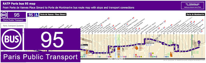
RATP Paris bus line 95 with stops, connections and street plan
The bus line 95 is another option of how to get to Musee du Louvre as there is a bus stop on route called Musee du Louvre located at the Place du Carrousel within a few metres of the I M Pei Pyramid Louvre main entrance, and this bus route travels from the outskirts of Paris at Porte de Vanves - Place Simard to Porte de Montmartre with numerous transport connections on its journey.
Paris bus line 95 stops:
Porte de Vanves - Place Simard, Adolphe Pinard*, Pont de la Vallee*, Bartholome*, Porte de Vanves**, Brancion*, Chauvelot**, Morillons - Brancion*, Morillons**, Brancion - Vouille*, Labrouste - Vouille**, Alleray*, Falguiere**, Procession*, Institut Pasteur, Pasteur - Docteur Roux*, Pasteur - Falguiere**, Armorique - Musee Postal, Gare Montparnasse, Montparnasse - Rue de l'Arrivee*, Montparnasse**, Rennes - Littre, Rennes - Saint-Placide, Rennes - d'Assas, Michel Debre, Saint-Germain-des-Pres, Jacob, Pont du Carrousel - Quai Voltaire, Musee du Louvre, Palais Royal - Comedie Francaise, Pyramides, Petits Champs - Danielle Casanova**, Opera - Quatre Septembre, Opera, Auber, Havre - Haussmann*, Gare Saint-Lazare - Havre*, Gare Saint-Lazare**, Gare Saint-Lazare - Rome, Europe, Bucarest, Place de Clichy, Place de Clichy - Caulaincourt*, Clichy - Caulaincourt**, Damremont - Caulaincourt (Sacre-Coeur), Damremont - Lamarck**, Place Jacques Froment, Damremont - Marcadet, Damremont - Ordener, Damremont - Championnet, Poteau - Belliard, Angelique Compoint, Rene Binet, G. de Nerval**, Porte de Montmartre.
* Stop served in direction of Porte de Vanves - Place Simard. ** Stop served in direction of Porte de Montmartre.
Paris bus line 95 main transport connections:
Metro Lines: 1, 2, 3, 4, 6, 7, 8, 9, 10, 12, 13, 14. Train Lines: A, E, J, L, N. Tram Line: T3a.
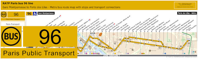
RATP Paris bus line 96 with stops, connections and street plan
However, if you are travelling in the direction of Porte des Lilas Metro from Gare Montparnasse, then you could catch the Paris bus line 96, as this has a stop going in this direction at Chatelet - Quai de Gesvres approximately 850 metres from The Louvre, but in the opposite direction you would end up walking further from the Ile de la Cite or Hotel de Ville.
Paris bus line 96 stops:
Gare Montparnasse, Montparnasse - Rue de l’Arrivee*, Montparnasse**, Rennes - Littre, Rennes - Saint-Placide, Rennes - d’Assas, Michel Debre, Eglise Saint-Sulpice*, Bonaparte - Saint-Germain**, Seine - Buci**, Saint-Germain - Odeon, Saint-Michel*, Saint-Michel - Saint-Germain**, Cite - Palais de Justice, Chatelet - Quai de Gesvres**, Coutellerie*, Hotel de Ville, Eglise Saint-Gervais**, Rue de Jouy**, Rue Vieille du Temple - Mairie du 4e*, Saint-Paul, Place des Vosges, Saint-Claude, Bretagne, Jean-Pierre Timbaud*, Oberkampf - Filles du Calvaire**, Jean-Pierre Timbaud - Richard Lenoir*, Oberkampf - Richard Lenoir**, Parmentier - Republique**, Parmentier*, Maison des Metallos*, Saint-Maur - Jean Aicard**, Couronnes*, Belleville - Menilmontant, Julien Lacroix, Henri Chevreau, Pyrenees - Menilmontant, Menilmontant - Pelleport, Saint-Fargeau, Piscine des Tourelles, Port des Lilas - Metro.
* Stop served in direction of Gare Montparnasse. ** Stop served in direction of Porte des Lilas - Metro.
Paris bus line 96 main transport connections:
Metro Lines: 1, 2, 3, 3bis, 4, 5, 6, 7, 8, 9, 10, 11, 12, 13, 14. Train Lines: A, B, C, D, N. Tram Line: T3b.
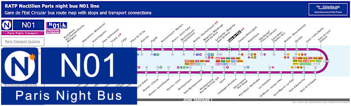
Paris Noctilien night bus N01 map with stops and transport connections
Noctilien is a night bus service that operates throughout Paris and the region to provide public transport when other options such as regular buses, the Metro and trains have stopped running for the early hours, and here you can see the Noctilien line N01, which is classed as the Circulaire Interieure running in a circuit from Gare de l'Est, and the nearest N01 night bus stop to The Louvre is on the opposite side of the River Seine called the Pont du Carrousel - Quai Voltaire stop.
Paris night bus line N01 stops:
Gare de l'Est, Jacques Bonsergent, Republique, Oberkampf - Filles du Calvaire, Saint-Gilles - Chemin Vert, Bastille - Beaumarchais, Bastille, Lyon - Ledru-Rollin, Gare de Lyon - Diderot, Quai de la Rapee, Gare d'Austerlitz, Saint-Marcel - La Pitie, Saint-Marcel - Jeanne d'Arc, Les Gobelins, Port Royal - Berthollet, Observatoire - Port Royal, Campagne Premiere, Vavin, Montparnasse - Rue de l'Arrivee, Gare Montparnasse, Montparnasse, Rennes - Littre, Rennes - Saint-Placide, Rennes - d'Assas, Michel Debre, St-Germain-des-Pres, Pont du Carrousel - Quai Voltaire, Henry de Montherlant, Assemblee Nationale, Pont Alexandre III, Palais de la Decouverte, Rond-Point des Champs-Elysees - Matignon, Haussmann - Miromesnil, Saint-Augustin, Gare Saint-Lazare, Trinite, Liege, Place de Clichy, Blanche, Pigalle, Rochechouart - Martyrs, Anvers - Sacre-Coeur, Rochechouart - Clignancourt, Barbes - Rochechouart, Magenta - Mauberge - Gare du Nord, La Fayette - Magenta - Gare du Nord, Gare de l'Est.
Paris night bus line N01 main transport connections:
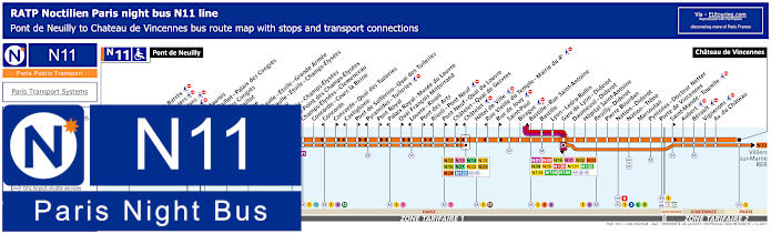
Paris Noctilien night bus N11 map with stops and transport connections
Whereas here you have the Noctilien night bus line N11, which is how to get to Chateau de Vincennes or to Pont de Neuilly in the opposite direction, and as you can tell from the maps and timetables, this has numerous stops at tourist attractions including Palais de Congres, Concorde, Palais Royal - Musee du Louvre, Bastille, etc, which runs from approximately 12:30am to 6am.
Paris night bus line N11 stops:
Pont de Neuilly, Maurice Barres, Les Graviers, Les Sablons, Marche, Andre Maurois*, Porte Maillot - Palais des Congres*, Palais des Congres**, Porte Maillot**, Argentine, Charles de Gaulle - Etoile - Grande Armee, Charles de Gaulle - Etoile - Champs-Elysees, George V, La Boetie - Champs-Elysees, Rond-Point des Champs-Elysees, Champs-Elysees - Clemenceau, Concorde - Cours la Reine, Concorde*, Concorde - Quai des Tuileries**, Castiglione*, Pont de Solferino - Quai des Tuileries**, Pyramides - Tuileries*, Pont Royal**, Palais Royal - Musee du Louvre*, Quai Francois Mitterrand**, Louvre - Rivoli*, Pont des Arts**, Rivoli - Pont Neuf*, Pont Neuf - Quai du Louvre**, Chatelet - Quai de Gesvres**, Chatelet*, Hotel de Ville, Rue Vieille du Temple - Mairie du 4e*, Rue de Jouy**, Saint-Paul, Birague, Bastille - Rue Saint-Antoine, Bastille, Lyon - Ledru-Rollin, Gare de Lyon - Diderot, Daumesnil - Diderot, Hopital Saint-Antoine, Reuilly - Diderot, Pierre Bourdan, Nation - Diderot, Nation - Trone, Marsoulan, Pyrenees - Docteur Netter, Porte de Vincennes, Saint-Mande - Tourelle**, Aubert, Berault, Vignerons, Avenue du Chateau, Chateau de Vincennes.
* In direction of Pont de Neuilly. ** In direction of Chateau de Vincennes.
Paris night bus line N11 main transport connections:
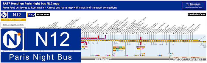
Paris Noctilien night bus N12 map with stops and transport connections
The Noctilien N12 night bus line goes from Romainville - Carnot and has numerous stops on route including the Pont des Arts - Quai de Conti within walking distance of the Louvre museum, although as you can see from the maps and timetables, this and several other night bus stops only go in the direction of Pont de Sevres, yet some go the opposite direction as well.
Paris night bus line N12 stops:
Pont de Sevres, Billancourt, Marcel Sembat, Rene Descartes, Henri Martin, Porte de Saint-Cloud, Porte de Saint-Cloud - Murat, Versailles - Chardon Lagache, Versailles - Exelmans, Victorien Sardou, Wilhem, Pont Mirabeau, Degas, Radio France - Pont de Grenelle, Pont de Grenelle - Maurice Bourdet, Pont de Grenelle - Pl. Fernand Forest, Charles Michels, Avenue Emile Zola, Cambronne, Sevres - Lecourbe, Pasteur - Lycee Buffon, Pasteur - Falguiere, Armorique - Musee Postal, Gare Montparnasse, Montparnasse - Rue de l’Arrivee, Montparnasse, Rennes - Littre, Rennes - Saint-Placide, Rennes - D'Assas, Michel Debre, Bonaparte - Saint-Germain, Saint-Germain-des-Pres, Jacob, Seine - Buci, Pont du Carrousel - Quai Voltaire, Saint-Germain - Odeon, Pont des Arts - Quai de Conti, Pont Neuf - Quai des Grands Augustins, Saint-Michel, Saint-Michel - Saint-Germain, Cite - Palais de Justice, Chatelet, Les Halles - Centre Georges Pompidou, Centre Georges Pompidou, Turbigo - Etienne Marcel, Grenier St-Lazare - Quartier de l’Horloge, Reaumur - Sebastopol, Reaumur - Arts et Metiers, Arts et Metiers, Square du Temple, Turbigo - Republique, Republique, Ferry - Lenoir, Parmentier - Republique, Saint-Maur - Jean Aicard, Jules Ferry, Goncourt, Belleville - Menilmontant, Vouronnes, Belleville, Pyrenees - Belleville, Jourdain, Pixerecourt, Pelleport - Belleville, Porte des Lilas, Les Bruyeres, Mairie des Lilas, Rue de Noisy-le-Sec, Paul de Kock, Joseph Depinay, Gagarine, Cimetiere de Bagnolet, Floreal, Les Noyers, Mairie de Romainville, Gabriel Husson, Romainville - Carnot.
Paris night bus line N12 main transport connections:
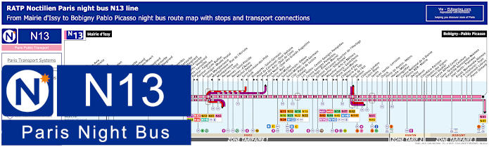
Paris Noctilien night bus N13 map with stops and transport connections
Here we have the maps and timetables for the Noctilien bus line N13, which travels between Mairie d'Issy and Bobibgny - Pablo Picasso with numerous stops on route that have transport connections, not forgetting stopping close to Paris tourist attractions like Porte de Pantin for Zenith and Pont des Arts - Quai Conti for The Louvre, but please take note that some night bus stops only travel in a particular direction.
Paris night bus line N13 stops:
Mairie d'Issy, Victor Hugo, Freres Voisin*, Colonel Pierre Avia*, Maison de Retraite**, Severine**, Louis Armand*, Porte d'Issy**, Suzanne Lenglen*, Balard*, Firmin Gillot**, Balard - Lecourbe*, Lycee Louis Armand*, Duranton*, Vaugirard - Croix Nivert**, Hopital de Vaugirard**, Convention - Lecourbe*, Convention - Vaugirard**, Abbe Groult, Mairie du 15e*, Vaugirard - Favorites**, Cambronne - Lecourbe*, Cambronne - Vaugirard**, Volontaires - Lecourbe*, Volontaires - Vaugirard**, Sevres - Lecourbe*, Pasteur - Falguiere**, Pasteur - Lycee Buffon*, Armorique - Musee Postal, Gare Montparnasse, Montparnasse - Rue de l'Arrivee*, Montparnasse**, Rennes - Littre, Rennes - Saint-Placide, Rennes - d'Assas, Michel Debre, Saint-Germain-des-Pres*, Jacob*, Bonaparte - Saint-Germain**, Pont du Carrousel - Quai Voltaire*, Pont des Arts - Quai Conti*, Pont Neuf - Quai des Grands Augustins*, Seine - Buci**, Saint-Michel*, Saint-Germain - Odeon**, Saint-Michel - Saint-Germain**, Cite - Palais de Justice, Chatelet, Les Halles - Centre Georges Pompidou**, Centre Georges Pompidou*, Turbigo - Etienne Marcel**, Grenier St-Lazare - Quartier de l'Horloge*, Reaumur - Sebastopol**, Reaumur - Arts et Metiers*, Strasbourg - Saint-Denis**, Porte Saint-Martin*, Chateau d'Eau**, Mairie du 10e*, Gare de l'Est, Verdun**, Chateau Landon, Louis Blanc, Jaures, Jean Jaures - Lorraine, Ourcq, Porte de Pantin - Metro, Hoche - Metro, Montgolfier, Centre National de la Danse, Pantin RER - Mairie, Delizy, Diderot, Cimetiere Parisien, Chemin des Vignes, Henri Gautier, Lycee Alfred Costes, Gare - Grande Ceinture, Escradille Normandie-Niemen - Jean Jaures - Tramway, Escadrille Normandie-Niemen - Paul Vaillant-Couturier - Tram, Lieutenant Lebrun, Pierre Semard, Bobigny - Pablo Picasso.
* Only served in the direction of Mairie d'Issy. ** Only served in the direction of Bobigny - Pablo Picasso.
Paris night bus line N13 main transport connections:
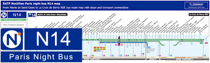
Paris Noctilien night bus N14 map with stops and transport connections
The Noctilien night bus line N14 travels between Mairie de Saint-Ouen and La Croix de Berny RER with many stops and transport connections on route including at Chatelet, which is the night bus stop you would need after visiting the Louvre before heading back to your accommodation, etc.
Paris night bus line N14 stops:
Mairie de Saint-Ouen - Republique, Ernest Renan, Garibaldi, Kleber, Gerard de Nerval, Angelique Compoint, Camille Flammarion, Porte de Clignancourt, Simplon, Marcadet - Poissonniers, Chateau Rouge, Barbes - Rochechouart, Magenta - Mauberge - Gare du Nord, La Fayette - Magenta - Gare du Nord, Gare de l'Est, Magenta - Saint Martin*, Chateau d'Eau**, Mairie du 10e*, Porte Saint-Martin*, Strasbourg - Saint-Denis**, Reaumur - Sebastopol**, Reaumur - Arts et Metiers*, Turbigo - Etienne Marcel**, Grenier St-Lazare - Quartier de l'Horloge*, Les Halles - Centre Georges Pompidou**, Centre Georges Pompidou*, Chatelet, Cite - Palais de Justice, Saint-Michel - Saint-Germain, Les Ecoles, Luxembourg, Auguste Comte, Val du Grace, Observatoire - Port Royal, Hopital Saint-Vincent de Paul, Denfert-Rochereau -Arago, Denfert-Rochereau*, Denfert-Rochereau - Daguerre**, Mouton - Duvernet, Alesia - Maine*, Alesia - General Leclerc, Porte d'Orleans, Porte d'Orleans - Metro*, Gabriel Peri, Leon Gambetta, Vache Noire, Jean-Marin Naudin, Gustave Courbet - Metro, Grange Ory, Carnot - Aristide Briand, Marcel Bonnet, Pont Royal - RER, Cite Jardins, Place de la Resistance - Charles de Gaulle, Rue du 8 mai 1945, Bourg-la-Reine RER*, Condorcet - Mairie - RER**, Petit Chambord - Lycee Lakanal, Les Cottages, La Fontaine, Normandie, General de Gaulle - Croix de Berny*, La Croix de Berny RER.
* Bus stop served in direction of La Croix Berny RER. ** Bus stop served in direction of Mairie de Saint-Ouen - Republique.
Paris night bus line N14 main transport connections:
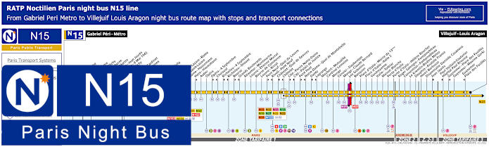
Paris Noctilien night bus N15 map with stops and transport connections
Travelling between Gabriel Peri - Metro and Villejuif - Louis Aragon, both within tariff zone 3 of the Paris region, the Noctilien bus line N15 also has numerous bus stops in the city at key locations including Chatelet, Gare Saint-Lazare, Opera, Notre Dame - Quai de Montebello, etc, not forgetting the Louvre - Rivoli night bus stop.
Paris night bus line N15 stops:
Gabriel Peri - Metro, Place Voltaire, Leon Blum, Landy - Martre*, Mairie de Clichy, Jaures - Barbusse**, Barbusse - Martre*, Victor Hugo - Jean Jaures**, Victor Hugo - 8 Mai 1945*, Porte de Clichy, Boulay, Brochant - Cardinet, Rue des Moines*, Legendre, La Fourche, Ganneron, Place de Clichy, Bucarest, Europe, Gare Saint-Lazare - Rome**, Gare Saint-Lazare, Rome - Haussmann*, Auber, Opera, Opera - 4 Septembre**, Choiseul*, Richelieu - 4 Septembre**, Richelieu - Drouot*, Bourse**, Grands Boulevards*, Reaumur - Montmartre, Louvre - Etienne Marcel, Bourse de Commerce, Louvre - Rivoli, Pont Neuf - Quai du Louvre**, Rivoli - Pont Neuf*, Chatelet - Quai des Gesvres**, Chatelet*, Cite - Parvis Notre-Dame**, Cite - Palais de Justice*, Petit Pont**, Notre-Dame - Quai de Montebello*, Dante**, Lagrange*, Maubert - Mutualite, Cardinal Lemoine, Monge, Censier - Daubenton, Monge - Claude Bernard, Les Gobelins, Banquier, Place d'Italie - Mairie du 13eme, Place d'Italie - Italie 2, Vandrezanne, Italie - Tolbiac, Maison Blanche, Porte d'Italie, Porte d'Italie - Helene Boucher, Roger Salengro - Fontainebleau, Convention - Fontainebleau, Le Kremlin-Bicetre Metro, Dauphin - Anatole France, Henri Barbusse, Dispensaire Danielle Casanova, Jean Jaures**, Paul Vaillant-Couturier - Hopital Paul Brousse*, Guynemer - Place des Fusilles**, Guynemer - Maxime Gorki, Guynemer - Place des Fusilles*, Villejuif - Louis Aragon.
* Stop served in the direction of Gabriel Peri - Metro. ** Stop served in the direction of Villejuif - Louis Aragon.
Paris night bus line N15 main transport connections:
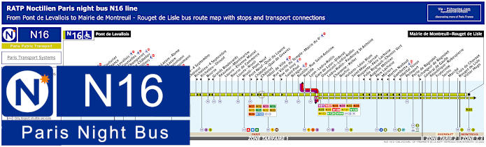
Paris Noctilien night bus N16 map with stops and transport connections
However, the Noctilien bus line N16 goes from Pont de Levallois to Mairie de Montreuil - Rouget de Lisle, again stopping at train stations and tourist attractions, and as you can see from the night bus maps and timetables, this also has a stop at Louvre - Rivoli for the Musee du Louvre.
Paris night bus line N16 stops:
Pont de Levallois, Picasso*, Vaillant - Couturier*, Anatole France**, Mairie de Levallois*, Porte de Courcelles*, Porte de Champerret, Pereire - Le Chatelier*, Pereire - Villiers**, Europe, Gare Saint-Lazare - Rome**, Gare Saint-Lazare, Rome - Haussmann*, Havre - Haussmann**, Auber, Opera, Opera - 4 Septembre**, Choiseul*, Richelieu - 4 Septembre**, Richelieu - Drouot*, Bourse**, Grands Boulevards*, Reaumur - Montmartre, Louvre - Etienne Marcel, Bourse de Commerce, Louvre - Rivoli, Rivoli - Pont Neuf*, Pont Neuf - Quai du Louvre**, Chatelet - Quai de Gesvres**, Chatelet*, Hotel de Ville, Rue Vieille du Temple - Mairie du 4e*, Rue de Jouy**, Saint-Paul, Birague, Bastille - Rue Saint-Antoine, Bastille, Lyon - Ledru-Rollin, Gare de Lyon - Diderot, Daumesnil - Ledru-Rollin, Ledru-Rollin - Faubourg St-Antoine, Charonne - Keller, Basfroi, Voltaire - Leon Blum, Saint-Maur - Servan, Roquette - Pere Lachaise, Folie Regnault - Chemin Vert*, Auguste Metivier*, Pere Lachaise**, Muriers*, Martin Nadaud*, Gambetta*, Hopital Tenon*, Pelleport, Porte de Bagnolet, Echangeur de Bagnolet**, General de Gaulle, Republique - Robespierre, Fraternite, Sorins, Marche, Croix de Chavaux - Rouget de Lisle, Victor Hugo, Mairie de Montreuil - Rouget de Lisle.
* Served in direction of Pont de Levallois. ** Served in direction of Mairie de Montreuil - Rouget de Lisle.
Paris night bus line N16 main transport connections:
Paris Noctilien night bus N21 map with stops and transport connections
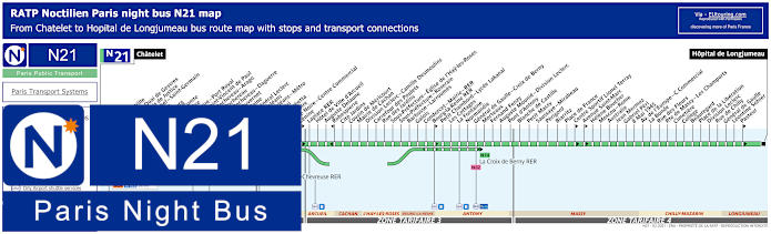
Whereas the Noctilien line N21 has a night bus route travelling between Hopital de Longjumeau and Chatelet where it stops close to Tour Saint Jacques, which is an option of night travel to various other transport hubs or to your accommodation having been to The Louvre or enjoying other places around the area.
Paris night bus line N21 stops:
Chatelet, Hotel de Ville, Chatelet - Quai de Gesvres, Cite - Palais de Justice, Saint-Michel - Saint-Germain, Les Ecoles, Luxembourg, Auguste Comte, Val de Grace, Observatoire - POrt Royal, Hopital Saint-Vincent de Paul, Denfert-Rochereau - Arago, Denfert-Rochereau, Denfert-Rochereau - Daguerre, Mouton-Duvernet, Alesia - Maine, Alesia - General Leclerc, Porte d'Orleans, Porte d'Orleans - Metro, Gabriel Peri, Leon Gambetta, Vache Noire, Vache Noire - Centre Commercial, Lenine, Laplace RER, Hotel de Vill d'Arcueil, Auguste Delaune, Robespierre, Cite Jardins, Cousin de Mericourt, Mairie de Cachan, Division Leclerc - Camille Desmoulins, Carrefour des Poulets, Rue des Jardins, Sous-Prefecture - Eglise de l'Hay-les'Roses, Sous-Prefecture - Roseraie, Barbusse - Larroumes, Galois, Condorcet - Mairie - RER, Bourg-la-Reine RER, Petit Chambord - Lycee Lakanal, Les Cottages, La Fontaine, Normandie, General de Gaulle - Croix de Berny, Morteaux, Fernand Fenzy, Auguste Mounie - Division Leclerc, Pont d'Antony, Blanche de Castille, Petit Massy, Saussaye - Mirabeau, Perigord, Biarritz, Place de France, Centre Sportif Lionel Terray, Avenue Saint-Marc, Helene Boucher, Moscou - Rome, Australie, Jean Mermoz, Gabriel Peri, 8 Mai 1945, Avenue de l'Europe - Centre Commercial, La Bonde, Rue des Fleurs, Route de Massy - Les Champarts, Cimetiere, College, Beauregard, Place de la Liberation, Division Leclerc, Rue de Chilly, General de Gaulle, Leontine Sohier, Pasteur, Hopital de Longjeumeau.
Paris night bus line N21 main transport connections: Metro Lines: 1, 4, 6, 7, 11, 14. Train Lines: A, B, D. Tram Line: T3a. Bus Lines: N01, N02, N11, N12, N13, N14, N15, N16, N22, N23, N24, N62, N66, N122, TVM (14).
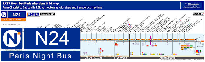
Paris Noctilien night bus N24 map with stops and transport connections
The Noctilien N24 night bus line travels from Satrouville RER to Chatelet and as you can see from the maps and timetables there are several night bus stops that are only served in a particular direction, so to get from the former palace of The Louvre you would need either the Louvre - Rivoli or the Palais Royal - Musee du Louvre stop in one direction but the Quai Francois Mitterrand stop in the other.
Paris night bus line N24 stops:
Satrouville RER, Poste, Stalingrad, Jean Mermoz, Voltaire, Edouard Vaillant, Eglise, Picardie, Charles de Gaulle, Quatre Chemins, Rue de Chatou, Clemenceau, Condorcet, Val Notre-Dame, La Berthie, Albert 1er, Place des Droits de l'Homme, La Grace de Dieu, Pont de Bezons, Parc Pierre Lagravere, Victor Basch, Jacqueline Auriol, Gare de La Garenne-Colombes, La Garenne-Colombes - Charlebourg, Nordmann, Les Fauvelles, Dieppe, Faubourg de l'Arche, Caron, La Defense, Boieldieu**, Gallieni**, Gambetta*, Bellini**, Alsace*, Pont de Neuilly - Rive Gauche, Pont de Neuilly - Metro, Maurice Barres, Les Graviers, Les Sablons, Marche, Andre Maurois*, Porte Maillot - Palais de Congres*, Palais de Congres**, Porte Maillot**, Argentine, Charles de Gaulle - Etoile - Grande Armee, Charles de Gaulle - Etoile - Champs-Elysees, George V, La Boetie - Champs-Elysees, Rond-Point des Champs-Elysees, Champs-Elysees - Clemenceau, Concorde - Cours la Reine, Concorde*, Concorde - Quai des Tuileries**, Castiglione*, Pont de Solferino - Quai des Tuileries**, Pyramides - Tuileries*, Pont Royal**, Palais Royal - Musee du Louvre*, Quai Francois Mitterrand**, Pont des Arts**, Louvre - Rivoli*, Rivoli - Pont Neuf*, Pont Neuf - Quai du Louvre**, Chatelet - Quai de Gesvres**, Chatelet.
* Stop served in direction of Sartrouville RER. ** Stop served in direction of Chatelet.
Paris night bus line N24 main transport connections:
Metro Lines: 1, 2, 4, 6, 7, 8, 9, 11, 12, 14. Train Lines: A, B, C, D, J, L, U. Tram Line: T2. Bus Lines: N01, N02, N11, N12, N13, N14, N15, N16, N21, N22, N23, N122, N153.
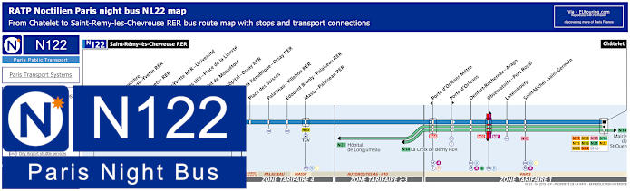
Paris Noctilien night bus N122 map with stops and transport connections
But here you have the maps and timetables for Noctilien N122 night bus that goes from Saint-Remy-les-Chevreuse RER to Chatelet, which is the night bus stop that you would need if coming from the Musee du Louvre, and as you can see, this has transport connections to many other Noctilien lines and travels to the outskirts of the Paris region.
Paris night bus line N122 stops:
Saint-Remy-les-Chevreuse RER, 11 Novembre - Courcelle-sur-Yvette RER, Gif-sur-Yvette RER, Bures-sur-Yvette RER - Universite, Mairie des Ulis - Place de la Liberte, Rond-Point de Mondetour, Mairie - Hopital - Orsay RER*, Place de la Republique - Orsay RER*, Place des Suisses, Palaiseau - Villebon RER, Edouard Branly - Palaiseau RER, Massy - Palaiseau RER, Porte d'Orleans Metro*, Porte d'Orleans*, Denfert-Rochereau - Arago, Observatoire - Port Royal, Luxembourg, Saint-Michel - Saint-Germain, Chatelet.
* Night bus stop only served in a specific direction.
Paris night bus line N122 main transport connections:
Paris Open Tour bus sightseeing tour map for Blue, Red and Green bus lines with stops and timetables
Open Tour are a hop on and hop off sightseeing bus tour company in Paris that provide different routes to get you around the city where you can get off and on as much as you like during your chosen ticket time, also being able to enjoy full circuits as well.
So as you can see from the Open Tour maps, timetables along with ticketing information, the most convenient bus stop for the Musee du Louvre is the Blue Line route and stop 4 at Place du Carrousel, although there is another being stop 3 at 3 Avenue de l'Opera, which is by the Comedie Francaise and Palais Royal, at a slightly further yet interesting walk.
1: Haussman - Opera - Visitor centre - 13 Rue Auber, 75009 2: Opera - 4 Septembre - 49 Avenue de l'Opera, 75002 3: Palais-Royal - Comedie Francaise - 3 Avenue de l'Opera, 75002 4: Musee du Louvre - Place du Carrousel, 75001 5: Pont Neuf - Quai des Orfevres - Face au 64 Quai des Orfevres, 75001 6: Notre-Dame - Visitor Centre - 4 Rue du Petit Pont, 75005 7: Musee d'Orsay - 8 Quai Anatole France, 75007 8: Concorde - 12 Place de la Concorde, 75008 9: Champs-Elysees - Grand Palais - 14 Avenue des Champs-Elysees, 75008 10: Champs-Elysees - Disney Store - 60 Avenue des Champs-Elysees, 75008 11: Champs-Elysees - George V - 116 Avenue des Champs-Elysees, 75008 12: Champs-Elysees - Open Tour Kiosque - 125 Avenue des Champs-Elysees, 75008 13: Trocadero - Avenue du President Wilson, 75016 14: Tour Eiffel - 69 Quai Branly, 75007 15: Pont de l'Alma - 87 Quai Branly, 75007 16: Pont Alexandre III - Invalides - 41 Quai d'Orsay, 75007 17: Concorde-Royale - 4 Rue Royale, 75008 18: Madeleine - 18 Place de la Madeleine, 75008
Paris Open Tour bus sightseeing tour maps with stops and timetables:
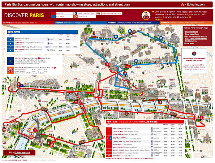
Big Bus Paris sightseeing tour map for Red and Blue bus lines with stops and timetables
Once called Les Cars Rouges, Big Bus Paris is also a hop on and hop off sightseeing tour bus operator, and as you can see from their route maps, timetables and information, you would need stop 5 of the Red Tour, which is located right near the Pont des Arts pedestrian bridge that faces The Louvre palace and the Musee du Louvre.
1: Tour Eiffel - Quai Branly, Entree 2 Tour Eiffel 2: Champ de Mars - Avenue Joseph Bouvard 3: Opera Garnier - Facing 15 Rue Scribe (next to the RoissyBus airport shuttle bus stop) 4: Louvre - Pyramide / Big Bus Information Centre - 11 Avenue de l’Opera (by Big Bus information center) 5: Louvre - Pont des Arts - Quai Francois Mitterrand (near Pont des Arts) 6: Notre Dame - 3 Rue Lagrange (outside souvenir shop, opposite Square Rene Viviani) 7: Musee d'Orsay - 58 Place Henry de Montherlant (facing the museum by Quai Anatole France) 8: Champs-Elysees - 156 Avenue des Champs-Elysees (facing the Arc de Triomphe by Rue de Tilsitt) 9: Grand Palais - Avenue Winston Churchill (facing the Grand Palais and Petit Palais) 10: Trocadero - Avenue Paul Doumer (next to the Palais de Chaillot close to the Statue of Benjamin Franklin)
Big Bus Paris daytime sightseeing tour maps with stops and timetables:
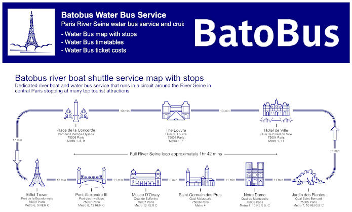
Paris Batobus map with river stops, timetables and ticket prices
The Batobus is a water bus that travels in a circuit along the River Seine with water bus stops known as docking stations at quays close to popular tourist attractions, and here with the maps and timetables along with additional ticketing information you can see this is like a hop on and hop off water bus transport option.
Although having to go down to a quay where the Batobus docks, means negotiating lots of steps, but as you can see, there is a water bus stop at the Quai du Louvre located in between the Pont Royal and Pont du Carrousel bridges over the River Seine on the same side of the river bank as the Musee du Louvre.
Batobus River Seine stops with attractions:
Eiffel Tower - Port de la Bourdonnais, Pont Alexandre III - Port des Invalides, Musee D'Orsay - Quai de Solferino, Saint Germain des Pres - Quai Malaquais, Notre Dame - Quai de Montebello, Jardin des Plantes - Quai Saint-Bernard, Hotel de Ville - Quai de l'Hotel de Ville, The Louvre - Quai du Louvre, Place de la Concorde - Port des Champs-Elysees.
Batobus main transport connections:
Metro lines 1, 4, 6, 7, 8, 9, 10, 11, 12 and 13 RER B and C
Batobus ticket prices:
Adult One Day Pass €17.00 Adult Two Day Pass €19.00 Child One Day Pass (aged 3-15 years) €8.00 Child Two Day Pass (aged 3-15 years) €10.00 Child (aged -3 years) FREE
Batobus water bus maps, timetables and ticket prices available:
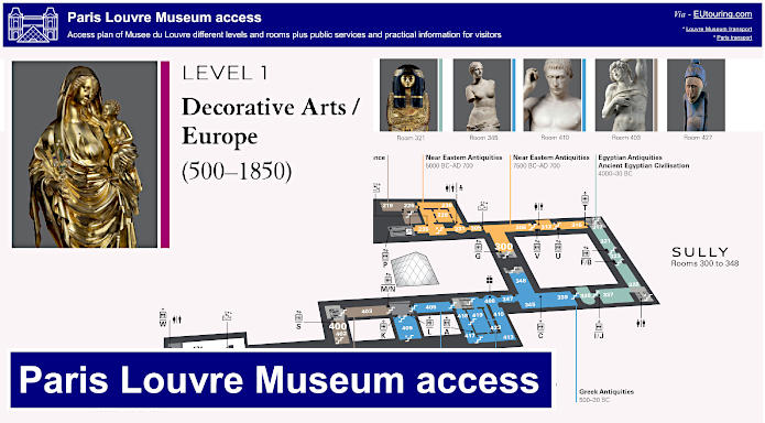
Louvre Museum access and exhibition plans with public services and disabled facilities
Louvre Museum access plan of levels, rooms, public services and practical information for visitors
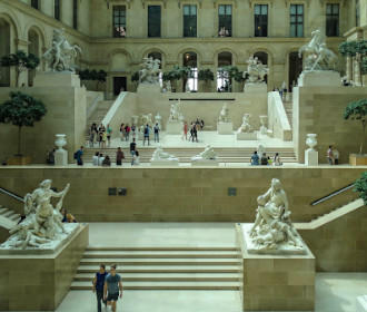
Here you can see a guide to the incredible Musee du Louvre providing practical information along with the various art works that have been categorised and placed within certain areas of the former royal palace. Yet there are also plans showing the different wings like Richelieu and levels along with entrances, services such as toilets and much more including listing major works such as the Mona Lisa by Leonardo da Vinci, so that you can get the most out of your museum visit.
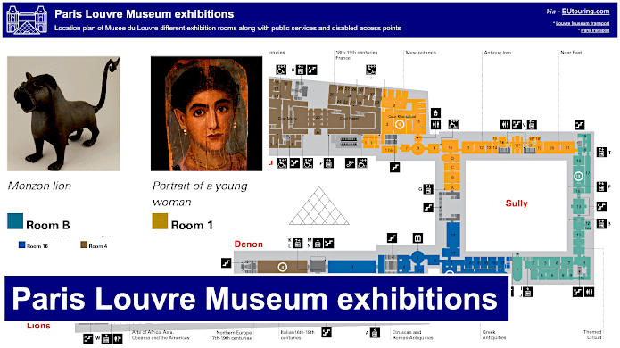
Louvre Museum plan of exhibition rooms along with public services and disabled access points
However, for those of you with disabilities, you may be pleased to know that the Musee du Louvre cater for wheelchair users and those with walking problems, with manual wheelchairs and folding seats available, yet there is even a tactile area for the sight impaired along with audio guides, and here you can see a guide for Louvre museum exhibition rooms along with public services and disabled access points such as wheelchair friendly lifts, etc.