How to get to Bastille in Paris using public transport
Below you will find how to get to Bastille Square and Opera Bastille along with all transport options including route maps and timetables for this popular area that can be downloaded by PDF or image format for your PC or mobile device. Having become a public transport hub for Metro, buses and Noctilien night buses in Paris, Bastille still has reminders of its past and the former Bastille Prison plus more recent attractions for you to enjoy.
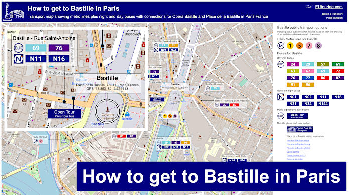
Bastille transport map of Metro lines and bus lines with stops, connections and street plan
So here you can see the Bastille transport hub showing a street plan for the Metro station and the bus stops located around the Bastille Square and also by the impressive building of the Opera Bastille, making travelling to and from these popular tourist attractions very easy, whether it be during the day or at night time and even to different areas of Paris and beyond.
How to get to Bastille public transport maps available:
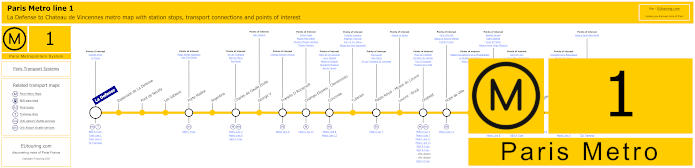
Paris Metro Line 1 map with stations, connections and points of interest
Here you can see a map showing Metro Line 1 of the Paris Metro, which travels from La Defense Grande Arche through to Chateau de Vincennes and has many additional stops, including at the Bastille Metro station on route, with one of its entrance and exit points being located virtually outside the Bastille Opera House and another at Place de la Bastille Square itself.
As a point of interest, when construction of Metro line 1 was being undertaken at Bastille, remains of the badly named Freedom Tower were uncovered and then moved to Square Henri-Galli in Paris where they can still be seen today, yet it was not until 1840 that a column called the July Column was erected in the centre of Bastille square.
Metro Line 1 stops:
La Defense, Esplanade de La Defense, Pont de Neuilly, Les Sablons, Porte Maillot, Argentine, Charles de Gaulle Etoile, George V, Franklin D Roosevelt, Champs-Elysees - Clemenceau, Concorde, Tuileries, Palais Royal - Musee du Louvre, Louvre - Rivoli, Chatelet, Hotel de Ville, Saint-Paul, Bastille, Gare de Lyon, Reuilly - Diderot, Nation, Porte de Vincennes, Saint-Mande, Berault, Chateau de Vincennes.
Metro line 1 main transport connections:
Metro Lines: 2, 4, 5, 6, 7, 8, 9, 11, 12, 13, 14. Train Lines: A, B, C, D, L, R, U. Tram Lines: T2, T3a, T3b.
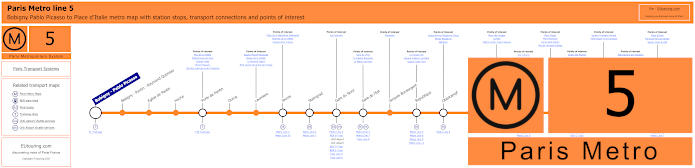
Paris Metro Line 5 map with stations, connections and points of interest
Whereas this map shows the Paris Metro Line 5 that travels from Bobigny - Pablo Picasso to the Place d'Italie and stops at different stations on route such as Gare du Nord, Gare de l'Est and additional transport hubs for tourist attractions like Bastille Square, the Gare d'Austerlitz train station, etc.
In addition, for those of you interested in history, on the Bastille Metro line 5 platform in the direction of Bobigny you can see remains of the eastern moat from the former Bastille prison, which was destroyed in the 1700s after the Storming of the Bastille during the French Revolution, which is why there are major celebrations on 14th July each year and this is now one of the French National holidays.
Metro Line 5 stops:
Bobigny - Pablo Picasso, Bobigny - Pantin - Raymond Queneau, Eglise de Pantin, Hoche, Porte de Pantin, Ourcq, Laumiere, Jaures, Stalingrad, Gare du Nord, Gare de l'Est, Jacques Bonsergent, Republique, Oberkampf, Richard-Lenoir, Breguet - Sabin, Bastille, Quai de la Rapee, Gare d'Austerlitz, Saint-Marcel, Campo-Formio, Place d'Italie.
Metro line 5 main transport connections:
Metro Lines: 1, 2, 3, 4, 6, 7, 7b, 8, 9, 10, 11. Train Lines: B, C, D, E, H, K, P. Tram Lines: T1, T3b.
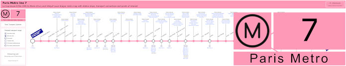
Paris Metro Line 7 map with stations, connections and points of interest
Whereas the nearest Metro stop for getting to Bastille is the Sully-Morland Metro station on Metro Line 7, which is a walk of approximately 500 metres from Bastille Square, and you will find that Line 7 goes from La Courneuve - 8 Mai 1945 then splits off at Maison Blanche to either a terminus at Mairie d'Ivry or Villejuif - Louis Aragon.
Metro line 7 stops:
La Courneuve - 8 Mai 1945, Fort d'Aubervilliers, Aubervilliers - Pantin - Quatre Chemins, Porte de la Villette, Corentin Cariou, Crimee, Riquet, Stalingrad, Louis Blanc, Chateau-Landon, Gare de l'Est, Poissonniere, Cadet, Le Peletier, Chaussee d'Antin - La Fayette, Opera, Pyramides, Palais Royal - Musee du Louvre, Pont Neuf, Chatelet, Pont Marie, Sully - Morland, Jussieu, Place Monge, Censier - Daubenton, Les Gobelins, Place d'Italie, Tolbiac, Maison Blanche, Porte d'Italie, Porte de Choisy, Porte d'Ivry, Pierre et Marie Curie, Mairie d'Ivry, Le Kremlin-Bicetre, Villejuif - Leo Lagrange, Villejuif - Paul Vaillant-Couturier, Villejuif - Louis Aragon.
Metro line 7 main transport connections:
Metro Lines: 1, 2, 3, 4, 5, 6, 7bis, 8, 9, 10, 11, 14. Train Lines: A, B, D, E, P. Tram Lines: T1, T3a, T3b, T7. Bus Line: RoissyBus.
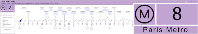
Paris Metro Line 8 map with stations, connections and points of interest
Although this map shows Line 8 of the Paris Metro that goes from the Balard Metro station through to Creteil - Pointe du Lac, which has stops on route by tourist attractions like the Ecole Militaire, Invalides, Concorde, Madeleine, Opera, the Grands Boulevards and numerous others including Bastille that has an entrance and exit also right by the Opera Bastille and others around the Bastille Square itself.
As another point of interest, there is special paving that has been placed strategically at Place de la Bastille square that indicates the location of the former fortress, measuring 66 metres in length by 34 metres in width, plus for those of you with a keen interest in its history, the Musee Carnavalet holds some models that were produced as souvenirs when the Bastille prison was first destroyed.
Metro line 8 stops:
Balard, Lourmel, Boucicaut, Felix Faure, Commerce, La Motte-Picquet - Grenelle, Ecole Militaire, La Tour-Maubourg, Invalides, Concorde, Madeleine, Opera, Richelieu-Drouot, Grands Boulevards, Bonne Nouvelle, Strasbourg - Saint-Denis, Republique, Filles du Calvaire, Saint-Sebastien - Froissart, Chemin Vert, Bastille, Ledru-Rollin, Faidherbe - Chaligny, Reuilly - Diderot, Montgallet, Daumesnil, Michel Bizot, Porte Doree, Porte de Charenton, Liberte, Charenton - Ecoles, Ecole Veterinaire de Maisons-Alfort, Maisons-Alfort - Stade, Maisons-Alfort - Les Juilliottes, Creteil - L'Echat, Creteil - Universite, Creteil - Prefecture, Creteil - Pointe du Lac.
Metro line 8 main transport connections:
Metro Lines: 1, 3, 4, 5, 6, 7, 9, 10, 11, 12, 13, 14. Train Lines: A, C. Tram Lines: T2, T3a. Bus Lines: RoissyBus, TVM (14).
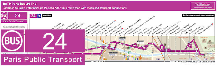
RATP Paris bus 24 map with stops, connections and street plan
The RATP Paris bus line 24 travels from the famous burial place of the Pantheon through to Ecole Veterinaire de Maisons-Alfort and this is one of the ways of how to get to Bercy Arena, also known as AccorHotels Arena, yet as you can see from the maps and their timetables, many stops are only served in a specific directions, which is the case for the Quai de la Rapee bus stop that will get you to Bastille Square with its opera house.
Paris bus line 24 stops:
Pantheon, Saint-Jacques - Gay-Lussac*, Musee et Institut Curie**, Feuillantines*, Ecole Normale Superieure**, Berthollet - Vauquelin, Monge - Claude Bernard, Les Gobelins*, Censier - Daubenton**, Saint-Marcel - Jeanne d’Arc*, Buffon - La Mosquee**, Saint-Marcel - La Pitie*, Buffon - Jardin des Plantes**, Gare d'Austerlitz, Gare d'Austerlitz - Cour Seine*, Quai de la Rapee**, Van Gogh*, Gare de Lyon - Maison de la RATP*, Gare de Lyon**, Ministere de l’Économie et des Finances, Gare de Bercy**, Bercy - Arena, Lachambeaudie**, Dijon - Lachambeaudie*, Baron Le Roy, Terroirs de France, Pont National - Quai de Bercy**, Centre Commercial, Port aux Lions, Pont Nelson Mandela, Les Berges de Charenton, Victor Hugo, Charenton-Ecoles, Edmond Nocard**, Pont de Charenton, Ecole Veterinaire de Maisons-Alfort.
* Served in direction of Ecole Veterinaire de Maisons-Alfort. ** Served in direction of The Pantheon.
Paris bus line 24 main transport connections:
Metro Lines: 1, 5, 6, 7, 8, 10, 14. Train Lines: A, B, C, D, R.
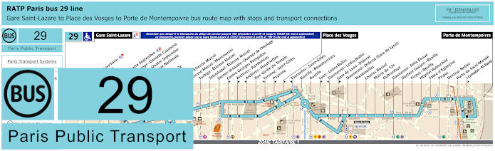
RATP Paris bus 29 map with stops, connections and street plan
Here you can see the Paris Bus route for the RATP line 29 that travels between Gare Saint-Lazare train station, Place des Vosges and the Porte de Montempoivre, which has many different bus stops such as Auber, Louvre - Etienne Marcel, Centre Georges Pompidou, and the Place de la Bastille at the Bastille stop on Rue de Lyon with one bus stop on either side of road depending upon your direction of travel.
Paris bus line 29 stops:
Gare Saint-Lazare, Havre - Haussmann, Auber, Opera, Opera - Quatre Septembre, Petits Champs - Danielle Casanova**, Richelieu - Quatre Septembre*, Bibliotheque Nationale**, Bourse*, Mairie du 2e*, Victoires, Louvre - Etienne Marcel**, Etienne Marcel - Montmartre, Turbigo - Etienne Marcel, Sebastopol - Etienne Marcel, Grenier St-Lazare - Quartier de l’Horloge, Centre Georges Pompidou*, Archives - Rambuteau*, Archives - Haudriettes**, Rue Vieille du Temple, Turenne - Saint-Gilles**, Payenne*, Place des Vosges*, Tournelles-Saint-Gilles**, Bastille - Beaumarchais, Bastille, Lyon - Ledru-Rollin*, Daumesnil - Ledru-Rollin**, Gare de Lyon - Diderot*, Daumesnil - Diderot (Gare de Lyon), Rambouillet, Charles Bossut, Mairie du 12e, Dubrunfaut, Daumesnil - Felix Eboue, Docteur Goujon - Reuilly, Picpus - Reuilly, Hopital Rothschild, Fabre d’Eglantine, Picpus, Docteur Netter, Porte de Saint-Mande, J. Lemaitre - M. Ravel*, Porte de Montempoivre.
* Served in direction of Porte de Montempoivre. ** Served in direction of Gare Saint-Lazare.
Paris bus line 29 main transport connections:
Metro Lines: 1, 3, 4, 5, 6, 7, 8, 9, 11, 12, 13, 14. Train Lines: A, D, E, J, L, R. Tram Line: T3a.
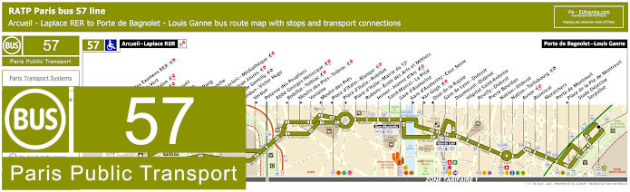
RATP Paris bus 57 map with stops, connections and street plan
Although the bus line 57 travels from the outskirts of Paris at Arcueil - Laplace RER in ticket tariff zone 2 through to Porte de Bagnolet - Louis Ganne with many bus stops on route including the Quai de la Rapee stop for bastille, but please bear in mind this only goes in the direction of Laplace RER train station as you can see from the bus map street plan and its timetables.
Paris bus line 57 stops:
Arcuil - Laplace RER, Maison des Examens RER**, Chaperon Vert*, Benoit Malon, Fraysse, Rue d’Arcueil**, Cite Verte**, Bout du Rang*, Reine Blanche*, Division Leclerc - Mediatheque**, Raspail - Jean Jaures*, Mairie de Gentilly**, Verdun - Victor Hugo**, Verdun*, Poterne des Peupliers, Abbe Georges Henocque, Bobillot - Tolbiac**, Moulin des Pres - Tolbiac*, Verlaine, Moulin des Pres**, Place d'Italie - Blanqui**, Place d'Italie - Bobillot*, Place d'Italie - Mairie du 13e, Rubens - Ecole des Arts et Metiers, Jenner - Jeanne d'Arc, Saint-Marcel - La Pitie, Gare d'Austerlitz, Gare d'Austerlitz - Cour Seine*, Van Gogh*, Quai de la Rapee**, Gare de Lyon - Diderot, Daumesnil - Diderot, Hopital Saint-Antoine, Reuilly - Diderot, Pierre Bourdan, Nation - Diderot, Nation - Taillebourg, Avron, Buzenval, Maraichers, Porte de Montreuil, Place de la Pte de Montreuil**, Stade Dejerine, Serpollet, Porte de Bagnolet - Louis Ganne.
* Served in direction of Porte de Bagnolet - Louis Ganne. ** Served in direction of Arcuil - Laplace RER.
Paris bus line 57 main transport connections:
Metro Lines: 1, 2, 3, 5, 6, 7, 8, 9, 10, 14. Train Lines: A, B, C, D, R. Tram Lines; T3a, T3b.
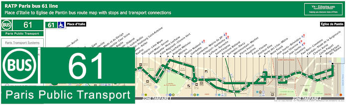
RATP Paris bus 61 map with stops, connections and street plan
Whereas these street maps and timetables show the Paris bus route for RATP bus line 61 travelling between Place d'Italie and Eglise de Pantin, which has many transport connections along the journey, yet for Bastille Opera House and Place de la Bastille, you would need the Quai de la Rapee bus stop.
Paris bus line 61 stops:
Place d'Italie, Place d’Italie - Auriol, Les Alpes, Nationale, Chevaleret, Quai de la Gare, Quai d'Austerlitz, Cite de la Mode et du Design, Gare d'Austerlitz - Cour Seine, Quai de la Rapee, Gare de Lyon - Diderot, Daumesnil - Ledru-Rollin, Ledru-Rollin - Faubourg Saint-Antoine, Charonne - Keller, Basfroi, Voltaire - Leon Blum, Saint-Maur - Servan, Roquette - Pere Lachaise, Folie-Regnault - Chemin Vert, Pere Lachaise, Auguste Metivier, Muriers, Martin Nadaud, Gambetta, Gambetta - Mairie du 20e, Pelleport - Gambetta, Lefevre - Surmelin, Saint-Fargeau, Adrienne Bolland, Surmelin - Darcy, Menilmontant - Mortier, Pierre Foncin, Fougeres, Freres Flavien, Docteur Gley, Porte des Lilas - Metro, Rene Fonck, Jean Jaures - Belvedere, Place Severine, Jean Jaures, Cimetiere, Paul Bert - Cimetiere, Candale - Stade de la Seigneurie, Charles Auray, Cecile Faguet, Manufacture des Tabacs, Eglise de Pantin.
Paris bus line 61 main transport connections:
Metro Lines: 1, 2, 3, 3bis, 5, 6, 7, 8, 9, 10, 11, 14. Train Lines: A, C, D, R. Tram Line: T3b.
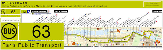
RATP Paris bus 63 map with stops, connections and street plan
Going from Gare de Lyon train station the Paris bus line 63 has a stop at Quai de la Rapee for Bastille going in the direction of Porte de la Muette, but also further on to Jardin d'Acclimatation at weekends, French holidays and during school holidays and as you can see from the street maps, this bus route stops at many tourist attractions including Iena for the Eiffel Tower and Pont Alexandre III, plus how to get to the Jardin des Plantes and many others.
Paris bus line 63 stops:
Jardin d'Acclimatation*, Fondation Louis Vuitton*, Route de Suresnes*, Pelouse de la Muette*, Porte de la Muette, Pte de la Muette - Octave Feuillet, Victor Hugo - Henri Martin, Pompe - Mairie du 16e, Sablons - Cortambert, Georges Mandel - Trocadero, Trocadero, Albert de Mun, Iena, Alma - Marceau, Bosquet - Rapp, Jean Nicot - Eglise Americaine, Pont des Invalides - Place de Finlande, Pont Alexandre III, Assemblee Nationale, Lille - Universite, Solferino - Bellechasse, Rue du Bac - Rene Char, Charlotte Perriand***, Sevres - Babylone***, Saint-Guillaume**, Michel Debre***, Saint-Germain-des-Pres**, Eglise Saint-Sulpice***, Seine - Buci**, Saint-Germain - Odeon, Cluny, Dante**, College de France***, Maubert - Mutualite**, Monge - Mutualite***, Institut du Monde Arabe***, Saint-Germain - Cardinal Lemoine**, Universite Paris 6, Cuvier, Jardin des Plantes**, Gare d'Austerlitz***, Gare d'Austerlitz - Cour Seine**, Quai de la Rapee***, Van Gogh**, Gare de Lyon.
* Only served on weekends, French public holidays and during school holidays. ** Stop served in direction of Paris Gare de Lyon. *** Stop served in direction of Jardin d'Acclimatation and Porte de la Muette.
Paris bus line 63 main transport connections:
Metro lines: 1, 4, 5, 6, 8, 9, 10, 12, 13, 14. Train lines: A, C, D, R.
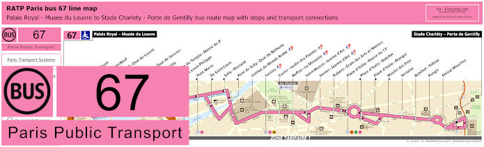
RATP Paris bus 67 map with stops, connections and street plan
The RATP Paris bus line 67 is one of the ways for how to get to Duc des Lombards Jazz Club via the Chatelet stop, along with many other entertainment venues and tourist attractions, as the 67 bus route goes from Stade Charlety - Porte de Gentilly stopping at Sully-Morland bus stop for getting to Bastille, on its way to the Palais Royal - Musee du Louvre stop, which is close to the famous Louvre Museum.
Paris bus line 67 stops:
Palais Royal - Musee du Louvre, Louvre - Rivoli, Rivoli - Pont-Neuf, Pont Neuf - Quai du Louvre, Chatelet, Chatelet - Quai de Gesvres, Hotel de Ville, Rue Vieille du Temple - Mairie du 4e, Pont Louis-Philippe, Pont Marie, Ile Saint-Louis, Sully - Morland, Pont de Sully - Quai de Bethune, Institut du Monde Arabe, Jussieu, Cuvier - Jardin des Plantes, Buffon - La Mosquee, Saint-Marcel - Jeanne d’Arc, Jenner - Jeanne d’Arc, Rubens - Ecole des Arts et Metiers, Place d’Italie - Mairie du 13e, Place d’Italie - Bobillot, Place d’Italie - Blanqui, Moulin des Pres, Verlaine, Bobillot - Tolbiac, Rungis, Amiral Mouchez, Stade Charlety - Porte de Gentilly.
Paris bus line 67 main transport connections:
Metro Lines: 1, 4, 5, 6, 7, 10, 11, 14. Train Lines: A, B, D. Tram Line: T3a.
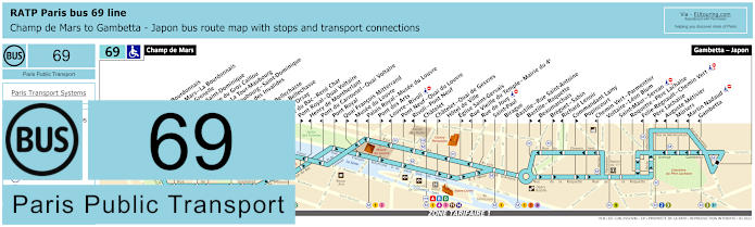
RATP Paris bus line 69 with stops, connections and street plan
However, these maps and timetables show the Paris Bus route for the RATP bus line 69, which travels from Gambetta - Japon and is a route for how to get to the Eiffel Tower, being it terminates at the Champ de Mars bus stop, and with over 45 additional bus stops to tourist attractions like Musee d'Orsay, Musee du Louvre and Chatelet, plus of course Bastille, where you have the Bastille - Roquette stop on the Rue de la Roquette close to the Opera Bastille in addition to the Bastille - Rue Saint-Antoine stop on opposite sides of the Bastille Square, this is a popular Paris bus line.
Paris bus line 69 stops:
Champ de Mars, Rapp - La Bourdonnais, Champ de Mars - La Bourdonnais*, Bosquet - Grenelle*, Bosquet - Saint-Dominique**, Saint-Pierre du Gros Caillou, Invalides - La Tour-Maubourg*, La Tour-Maubourg - Saint-Dominique**, Esplanade des Invalides, Bourgogne, Grenelle - Bellechasse*, Solferino - Bellechasse, Musee d’Orsay*, Rue du Bac - Rene Char, Pont Royal - Quai Voltaire**, Henry de Montherlant*, Pont du Carrousel - Quai Voltaire*, Pont Royal**, Quai Francois Mitterrand**, Musee du Louvre*, Palais Royal - Musee du Louvre*, Pont des Arts**, Louvre - Rivoli* ***, Pont Neuf - Quai du Louvre**, Rivoli - Pont Neuf*, Chatelet*, Chatelet - Quai de Gesvres**, Hotel de Ville, Eglise Saint-Gervais**, Rue Vieille du Temple - Mairie du 4e*, Rue de Jouy** ***, Saint-Paul, Birague, Bastille - Rue Saint-Antoine, Bastille - Roquette**, Beaumarchais*, Breguet - Sabin**, Richard Lenoir*, Commandant Lamy**, Popincourt, Chemin Vert - Parmentier*, Voltaire - Leon Blum, Saint-Maur - Servan***, Roquette - Pere Lachaise, Folie-Regnault - Chemin Vert* ***, Pere Lachaise**, Auguste Metivier*, Muriers, Martin Nadaud***, Gambetta, Gambetta - Japon.
* Stop served in direction of Champ de Mars. ** Stop served in direction of Gambetta - Japon. *** Not accessible to those with reduced mobility.
Paris bus line 69 main transport connections:
Metro Lines: 1, 2, 3, 3bis, 4, 5, 7, 8, 9, 11, 12, 13, 14. Train Lines: A, B, C, D.
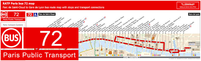
RATP Paris bus 72 map with stops, connections and street plan
Even though there are many bus stops that are only served in a specific direction, often due to one way traffic in Paris like you can see from these maps with their timetables, when it comes to getting to Bastille Opera House and Place de la Bastille Square via RATP bus line 72 travelling between Gare de Lyon and Parc de Saint-Cloud, you will find the Sully-Morland bus stop around 500 metres walk from these popular attractions.
Paris bus line 72 stops:
Parc de Saint-Cloud, La Colline, Pont de Saint-Cloud - Rive Gauche, Pont de Saint-Cloud - Albert Kahn, Rhin et Danube - Metro, Ancienne Mairie, Route de la Reine - Jean Jaures, Victor Hugo, La Tourelle, Porte de Saint-Cloud, Porte de Saint-Cloud - Murat, Versailles - Chardon Lagache, Versailles - Exelmans, Victorien Sardou, Wilhem, Pont Mirabeau, Degas, Radio France - Pont de Grenelle, Radio France, Lamballe - Ankara, Pont de Bir-Hakeim, Le Notre*, Pont d’Iena, Musee d’Art Moderne - Palais de Tokyo, Alma - Marceau, Palais de la Decouverte, Grand Palais, Cours la Reine - Chevaux de Marly*, Concorde*, Concorde - Quai des Tuileries**, Pont de Solferino - Quai des Tuileries**, Castiglione*, Pont Royal**, Pyramides - Tuileries*, Quai Francois Mitterrand**, Palais Royal - Musee du Louvre*, Louvre - Rivoli*, Pont des Arts**, Pont Neuf - Quai du Louvre**, Rivoli - Pont Neuf*, Rivoli - Chatelet*, Chatelet - Quai de Gesvres**, Hotel de Ville, Rue Vieille du Temple - Mairie du 4e*, Pont Louis Philippe**, Pont Marie*, Sully Morland, Port Henri IV**, Port de L'Arsenal*, Quai de la Rapee*, Pont Charles De Gaulle, Van Gogh**, Gare de Lyon.
* Served in direction of Parc de Saint-Cloud. ** Served in direction of Gare de Lyon.
Paris bus line 72 main transport connections:
Metro Lines: 1, 4, 5, 6, 7, 8, 9, 10, 11, 12, 13, 14. Train Lines: A, B, C, D, R.
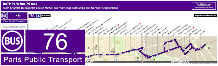
RATP Paris bus line 76 with stops, connections and street plan
Although here you can see a map that shows you the Paris Bus route for the RATP line 76 that travels from Chatelet to Bagnolet - Louise Michel, with additional bus stops in between like Bastille - Rue Saint-Antoine named after the road that gives it the name of bus stop, plus it goes to Bastille - Faubourg Saint-Antoine, which again is the same scenario, but on opposite sides of this iconic square in Paris and both will be within approximately 450 metres or under from either the Bastille Square or Opera Bastille.
Paris bus line 76 stops:
Chatelet, Hotel de Ville, Eglise Saint-Gervais, R. Vieille du Temple - Mairie du 4e, Rue de Jouy, Saint-Paul, Birague, Bastille - Rue Saint-Antoine, Bastille - Faubourg Saint-Antoine, La Boule Blanche, Ledru-Rollin - Faubourg Saint-Antoine, Charonne - Keller, Faidherbe, Charonne - Voltaire, Charonne - Philippe Auguste, Charonne - Bagnolet, La Reunion, Pyrenees - Bagnolet, Pelleport - Bagnolet, Porte de Bagnolet, Echangeur de Bagnolet, General de Gaulle, Gallieni - Metro, Centre de Sante, La Poste, Mairie de Bagnolet, Marie-Anne Colombier, Eglise de Bagnolet, Pierre Curie, Descartes, Les Malassis, Stalingrad, Girardot, Bagnolet - Louise Michel.
Paris bus line 76 main transport connections:
Metro Lines: 1, 2, 3, 4, 5, 7, 8, 9, 11, 14. Train Lines: A, B, D. Tram Line: T3b.
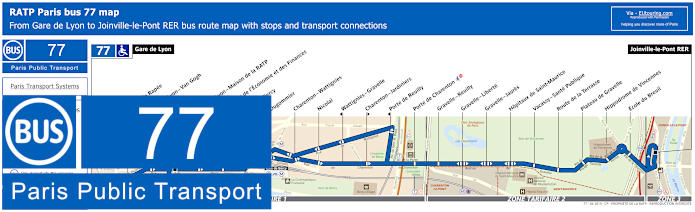
RATP Paris bus 77 map with stops, connections and street plan
So this shows the Paris bus line 77 that travels from Gare de Lyon through to Joinville-le-Pont RER and as you can see from the bus maps and timetables the nearest bus stop is the Quai de la Rapee stop, although please note that this travels in the direction of Joinville-le-Pont RER, so if you are thinking of how to get to Bastille and Opera Bastille, then you would need to actually go to the terminus of Gare de Lyon bus stop.
Paris bus line 77 stops:
Gare de Lyon, Quai de la Rapee, Gare de Lyon - Van Gogh, Gare de Lyon - Maison de la RATP, Ministere de l’Économie et des Finances, Gare de Bercy, Dugommier, Charenton - Wattignies, Nicolai, Wattignies - Gravelle, Charenton - Jardiniers, Porte de Reuilly, Porte de Charenton, Gravelle - Reuilly, Gravelle - Liberte, Gravelle - Jaures, Hopitaux de Saint-Maurice, Vacassy - Sante Publique, Route de la Terrasse, Plateau de Gravelle, Hippodrome de Vincennes, Ecole du Breuil, Joinville-le-Pont RER.
Paris bus line 77 main transport connections:
Metro Lines: 1, 6, 8, 14. Train lines: A, D, R. Tram Line: T3a.
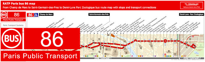
RATP Paris bus line 86 with stops, connections and street plan
But this map along with its timetables shows the Paris Bus route for the RATP line 86 that travels between Champ de Mars and Demi-Lune - Parc Zoologique, and on route there are additional bus stops including Ecole Militaire, the Saint-Francois-Xavier stop for getting to Les Invalides with the Tomb of Napoleon and of course the Place de la Bastille Square. So as you will see from the street maps, it has two different stops, with one being the Bastille - Henri IV on Boulevard Henri IV and the other is Bastille - Faubourg Saint-Antoine located on the Rue, or street of the same name, which will get you within easy reach of Bastille Opera House and Square.
Paris bus line 86 stops:
Champ de Mars, Rapp - La Bourdonnais, Champ de Mars - La Bourdonnais, Ecole Militaire, Duquesne - Lowendal, Breteuil*, El Salvador**, Saint-Francois-Xavier, Oudinot**, Duroc**, Vaneau - Saint-Romain**, Vaneau - Babylone*, Bac - Saint-Placide**, Bac - Babylone*, Sevres - Babylone, Michel Debre, Eglise Saint-Sulpice*, Saint-Germain-des-Pres**, Seine - Buci**, Saint-Germain - Odeon, Cluny, Dante**, College de France*, Maubert - Mutualite**, Monge - Mutualite*, Saint-Germain - Cardinal Lemoine**, Institut du Monde Arabe*, Pont Sully - Quai de Bethune, Sully - Morland, Bastille - Henri IV, Bastille - Faubourg Saint-Antoine, La Boule Blanche, Ledru-Rollin - Faubourg Saint-Antoine, Crozatier, Hopital Saint-Antoine, Faidherbe - Chaligny, Claude Tillier, Chevreul, Nation - Saint-Antoine, Nation - Trone, Marsoulan, Pyrenees - Docteur Netter, Porte de Vincennes, Saint-Mande - Tourelle, Mairie de Saint-Mande, Eglise de Saint-Mande, Jean Mermoz, Demi-Lune - Parc Zoologique.
* Stop served in direction of Champ de Mars. ** Stop served in direction of Demi-Lune - Parc Zoologique.
Paris bus line 86 main transport connections:
Metro Lines: 1, 2, 4, 5, 6, 7, 8, 9, 10, 12, 13. Train Line: A. Tram Lines: T3a, T3b.
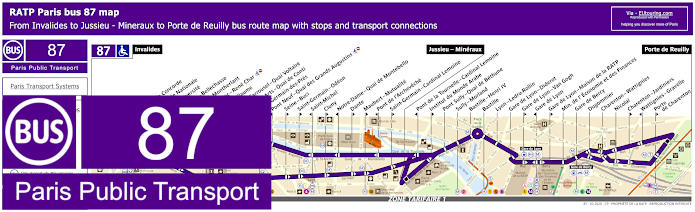
RATP Paris bus 87 map with stops, connections and street plan
So this map shows the Paris Bus route for the RATP line 87 that travels between Invalides, Jussieu - Mineraux and Porte de Reuilly, that has over 35 additional bus stops to places such as Musee d'Orsay, Pont de l'Archeveche, the Gare de Lyon train station, and again Bastille, which stops on the Rue de Lyon, the closest bus stop to Opera Bastille from the entrance, plus there is a stop on the Boulevard Henri IV as well.
Paris bus line 87 stops:
Invalides, Pont de la Concorde*, Assemblee Nationale, Lille-Universite**, Solferino - Bellechasse**, Henry de Montherlant*, Rue du Bac - Rene Char**, Saint-Guillaume**, Pont du Carrousel - Quai Voltaire*, Pont des Arts - Quai de Conti*, Saint-Germain-des-Pres**, Pont Neuf - Quai des Grands Augustins*, Seine - Buci**, Saint-Germain - Odeon**, Saint-Michel*, Cluny**, Notre-Dame - Quai de Montebello*, Dante**, Maubert - Mutualite**, Pont de l'Archeveche*, Saint-Germain - Cardinal Lemoine**, Jussieu - Mineraux, Pont de la Tournelle - Cardinal Lemoine*, Institut du Monde Arabe**, Pont Sully - Quai de Bethune, Sully - Morland, Bastille - Henri IV, Bastille, Lyon - Ledru-Rollin, Gare de Lyon - Diderot, Gare de Lyon - Van Gogh**, Gare de Lyon*, Gare de Lyon - Maison de la RATP**, Min. de l'Economie et des Finances, Gare de Bercy, Dugommier, Charenton - Wattignies, Nicolai, Charenton - Jardiniers**, Wattignies - Gravelle*, Porte de Charenton**, Porte de Reuilly.
* Bus stop served in direction of Invalides. ** Bus stop served in direction of Porte de Reuilly.
Paris bus line 87 main transport connections:
Metro Lines: 1, 4, 5, 6, 7, 8, 10, 12, 13, 14. Train Lines: A, B, C, D, R. Tram Line: T3a.
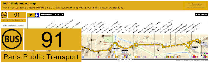
RATP Paris bus 91 map with stops, connections and route plan
Alternatively, the Paris Bus route for RATP line 91 travels between Montparnasse 2 - Gare TGV and Gare du Nord train station with its connections to Eurostar and RER trains, plus there are many other stops on route including Bastille, where you will see from the timetables and street plan above that it stops on Boulevard Beaumarchais and also the Rue de Lyon, which are on opposite sides of the Place de la Bastille intersection, both being very close to the July Column and the Opera Bastille.
Paris bus line 91 stops:
Montparnasse 2 - Gare TGV, Armorique - Musee Postal, Place de Catalogne, Gare Montparnasse, Montparnasse - Rue du Depart, Montparnasse, Montparnasse - Cinemas, Vavin, Campagne Premiere, Observatoire - Port Royal, Port Royal - Saint-Jacques, Port Royal - Berthollet, Les Gobelins, Saint-Marcel - Jeanne d'Arc, Saint-Marcel - La Pitie, Gare d'Austerlitz, Quai de la Rapee, Gare de Lyon - Diderot, Lyon - Ledru Rollin, Bastille, Bastille - Beaumarchais, Saint-Gilles - Chemin Vert, Saint-Claude, Oberkampf - Filles du Calvaire, Jean-Pierre Timbaud, Republique, Republique - Magenta, Jacques Bonsergent, Strasbourg - Magenta, Magenta - Saint-Martin, Gare de l'Est, Gare du Nord.
Paris bus line 91 main transport connections:
Metro Lines: 1, 2, 3, 4, 5, 6, 7, 8, 9, 10, 11, 12, 13, 14. Train Lines: A, B, C, D, E, H, K, N, P, R.
RATP Paris bus line 96 with stops, connections and street plan
However, the Paris bus line 96 travels from Gare Montparnasse through to Porte des Lilas - Metro and is one of the options for getting to Notre Dame Cathedral via the Cite - Palais de Justice stop, yet for getting to Bastille and Opera Bastille, the nearest bus stop to these tourist attractions is the Saint-Paul stop, but please look at the 96 bus maps and timetables carefully as many stops are direction dependant.
Paris bus line 96 stops:
Gare Montparnasse, Montparnasse - Rue de l’Arrivee*, Montparnasse**, Rennes - Littre, Rennes - Saint-Placide, Rennes - d’Assas, Michel Debre, Eglise Saint-Sulpice*, Bonaparte - Saint-Germain**, Seine - Buci**, Saint-Germain - Odeon, Saint-Michel*, Saint-Michel - Saint-Germain**, Cite - Palais de Justice, Chatelet - Quai de Gesvres**, Coutellerie*, Hotel de Ville, Eglise Saint-Gervais**, Rue de Jouy**, Rue Vieille du Temple - Mairie du 4e*, Saint-Paul, Place des Vosges, Saint-Claude, Bretagne, Jean-Pierre Timbaud*, Oberkampf - Filles du Calvaire**, Jean-Pierre Timbaud - Richard Lenoir*, Oberkampf - Richard Lenoir**, Parmentier - Republique**, Parmentier*, Maison des Metallos*, Saint-Maur - Jean Aicard**, Couronnes*, Belleville - Menilmontant, Julien Lacroix, Henri Chevreau, Pyrenees - Menilmontant, Menilmontant - Pelleport, Saint-Fargeau, Piscine des Tourelles, Port des Lilas - Metro.
* Stop served in direction of Gare Montparnasse. ** Stop served in direction of Porte des Lilas - Metro.
Paris bus line 96 main transport connections:
Metro Lines: 1, 2, 3, 3bis, 4, 5, 6, 7, 8, 9, 10, 11, 12, 13, 14. Train Lines: A, B, C, D, N. Tram Line: T3b.
Paris Noctilien night bus N01 map with stops and transport connections
This first Noctilien map with timetables show the Paris Noctilien Bus route for the RATP night bus line N01, which is referred to as Circulaire Interieure, and this provides a night bus service in a complete circuit from Gare de l'Est train station with stops at many different tourist attractions and popular areas of the city for night life including Pont Alexandre III, Place de Clichy, Pigalle, Republique and Bastille including for the Opera at the Place de la Bastille, to name a few.
Paris night bus line N01 stops:
Gare de l'Est, Jacques Bonsergent, Republique, Oberkampf - Filles du Calvaire, Saint-Gilles - Chemin Vert, Bastille - Beaumarchais, Bastille, Lyon - Ledru-Rollin, Gare de Lyon - Diderot, Quai de la Rapee, Gare d'Austerlitz, Saint-Marcel - La Pitie, Saint-Marcel - Jeanne d'Arc, Les Gobelins, Port Royal - Berthollet, Observatoire - Port Royal, Campagne Premiere, Vavin, Montparnasse - Rue de l'Arrivee, Gare Montparnasse, Montparnasse, Rennes - Littre, Rennes - Saint-Placide, Rennes - d'Assas, Michel Debre, St-Germain-des-Pres, Pont du Carrousel - Quai Voltaire, Henry de Montherlant, Assemblee Nationale, Pont Alexandre III, Palais de la Decouverte, Rond-Point des Champs-Elysees - Matignon, Haussmann - Miromesnil, Saint-Augustin, Gare Saint-Lazare, Trinite, Liege, Place de Clichy, Blanche, Pigalle, Rochechouart - Martyrs, Anvers - Sacre-Coeur, Rochechouart - Clignancourt, Barbes - Rochechouart, Magenta - Mauberge - Gare du Nord, La Fayette - Magenta - Gare du Nord, Gare de l'Est.
Paris night bus line N01 main transport connections:
Paris Noctilien night bus N02 map with stops and transport connections
Whereas here you have the Noctilien Bus route for the bus line N02, that is known as the Circulaire Exterieure, which also provides a night bus service in a complete circuit with stops at key locations like Bastille, right at the Bastille square, plus others where you can also get connections to different transport including those at the Gare Montparnasse train station, Gare de l'Est, Gare Saint-Lazare and Gare de Lyon to go to other areas of the city and beyond within the Paris region.
Paris night bus line N02 stops:
Gare Montparnasse, Montparnasse, Vavin, Campagne Premiere, Observatoire - Port Royal, Port Royal - Berthollet, Les Gobelins, Saint-Marcel - Jeanne d'Arc, Saint-Marcel - La Pitie, Gare d'Austerlitz, Quai de la Rapee, Gare de Lyon - Diderot, Lyon - Ledru-Rollin, Bastille, Bastille - Beaumarchais, Saint-Gilles - Chemin Vert, Oberkampf - Filles du Calvaire, Republique, Jacques Bonsergent, Gare de l'Est, La Fayette - Magenta - Gare du Nord, Magenta - Maubeuge - Gare du Nord, Barbes - Rochechouart, Rochechouart - Clignancourt, Anvers - Sacre-Coeur, Rochechouart - Martyrs, Pigalle, Blanche, Place de Clichy - Caulaincourt, Place de Clichy, Bucarest, Europe, Gare Saint-Lazare - Rome, Saint-Augustin, La Boetie - Percier, Rond-Point des Champs-Elysees - Franklin D. Roosevelt, Palais de la Decouverte, Pont Alexandre III, Assemblee Nationale, Solferino - Bellechasse, Saint-Guillaume, Saint-Germain-des-Pres, Michel Debre, Rennes - d'Assas, Rennes - Saint-Placide, Rennes - Little, Montparnasse - Rue de l'Arrivee, Gare Montparnasse.
Paris night bus line N02 main transport connections:
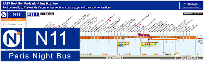
Paris Noctilien night bus N11 map with stops and transport connections
This next map and its timetables shows the Paris Noctilien Night Bus route for the RATP line N11, which is one of the ways for how to get to Chateau de Vincennes as this is the terminus going to Pont de Neuilly. Yet the route has night bus stops at many tourist attractions in Paris like Palais des Congres events venue, Concorde, Palais Royal - Musee du Louvre, Chatelet and of course Bastille where you will find the bus stop virtually opposite the Opera Bastille on the Rue de Lyon.
Paris night bus line N11 stops:
Pont de Neuilly, Maurice Barres, Les Graviers, Les Sablons, Marche, Andre Maurois*, Porte Maillot - Palais des Congres*, Palais des Congres**, Porte Maillot**, Argentine, Charles de Gaulle - Etoile - Grande Armee, Charles de Gaulle - Etoile - Champs-Elysees, George V, La Boetie - Champs-Elysees, Rond-Point des Champs-Elysees, Champs-Elysees - Clemenceau, Concorde - Cours la Reine, Concorde*, Concorde - Quai des Tuileries**, Castiglione*, Pont de Solferino - Quai des Tuileries**, Pyramides - Tuileries*, Pont Royal**, Palais Royal - Musee du Louvre*, Quai Francois Mitterrand**, Louvre - Rivoli*, Pont des Arts**, Rivoli - Pont Neuf*, Pont Neuf - Quai du Louvre**, Chatelet - Quai de Gesvres**, Chatelet*, Hotel de Ville, Rue Vieille du Temple - Mairie du 4e*, Rue de Jouy**, Saint-Paul, Birague, Bastille - Rue Saint-Antoine, Bastille, Lyon - Ledru-Rollin, Gare de Lyon - Diderot, Daumesnil - Diderot, Hopital Saint-Antoine, Reuilly - Diderot, Pierre Bourdan, Nation - Diderot, Nation - Trone, Marsoulan, Pyrenees - Docteur Netter, Porte de Vincennes, Saint-Mande - Tourelle**, Aubert, Berault, Vignerons, Avenue du Chateau, Chateau de Vincennes.
* In direction of Pont de Neuilly. ** In direction of Chateau de Vincennes.
Paris night bus line N11 main transport connections:
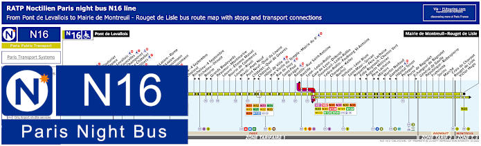
Paris Noctilien night bus N16 map with stops and transport connections
Although this map and timetable for getting to Bastille and its historical square plus modern opera house, shows the Noctilien Bus route for the RATP night bus line N16 that goes between the Pont de Levallois and Mairie de Montreuil - Rouget de Lisle with night bus stops on route such as Opera for how to get to Palais Garnier Opera House, Hotel de Ville, Gare Saint-Lazare and Gare de Lyon to name a few.
Paris night bus line N16 stops:
Pont de Levallois, Picasso*, Vaillant - Couturier*, Anatole France**, Mairie de Levallois*, Porte de Courcelles*, Porte de Champerret, Pereire - Le Chatelier*, Pereire - Villiers**, Europe, Gare Saint-Lazare - Rome**, Gare Saint-Lazare, Rome - Haussmann*, Havre - Haussmann**, Auber, Opera, Opera - 4 Septembre**, Choiseul*, Richelieu - 4 Septembre**, Richelieu - Drouot*, Bourse**, Grands Boulevards*, Reaumur - Montmartre, Louvre - Etienne Marcel, Bourse de Commerce, Louvre - Rivoli, Rivoli - Pont Neuf*, Pont Neuf - Quai du Louvre**, Chatelet - Quai de Gesvres**, Chatelet*, Hotel de Ville, Rue Vieille du Temple - Mairie du 4e*, Rue de Jouy**, Saint-Paul, Birague, Bastille - Rue Saint-Antoine, Bastille, Lyon - Ledru-Rollin, Gare de Lyon - Diderot, Daumesnil - Ledru-Rollin, Ledru-Rollin - Faubourg St-Antoine, Charonne - Keller, Basfroi, Voltaire - Leon Blum, Saint-Maur - Servan, Roquette - Pere Lachaise, Folie Regnault - Chemin Vert*, Auguste Metivier*, Pere Lachaise**, Muriers*, Martin Nadaud*, Gambetta*, Hopital Tenon*, Pelleport, Porte de Bagnolet, Echangeur de Bagnolet**, General de Gaulle, Republique - Robespierre, Fraternite, Sorins, Marche, Croix de Chavaux - Rouget de Lisle, Victor Hugo, Mairie de Montreuil - Rouget de Lisle.
* Served in direction of Pont de Levallois. ** Served in direction of Mairie de Montreuil - Rouget de Lisle.
Paris night bus line N16 main transport connections:
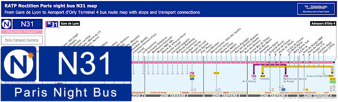
Paris Noctilien night bus N31 map with stops and transport connections
When other public transport has finished for the early hours, such as the Metro and trains, the Paris Noctilien buses take over between approximately 12:30am and 5:30am, and the Noctilien N31 night bus line is one of the ways for how to get to Orly Airport, as this route goes from Gare de Lyon to Aeroport d'Orly - Terminal 4, which is perfect if you have been enjoying a late evening around Bastille, with the night bus stop called Quai de la Rapee.
Paris night bus line N31 stops:
Gare de Lyon, Gare de Lyon - Van Gogh, Quai de la Rapee, Gare d'Austerlitz, Saint-Marcel - La Pitie, Place d'Italie - Mairie du 13e, Place d'Italie - Auriol, Nationale, Clisson, Patay - Tolbiac, Oudine, Porte de Vitry, Chateau des Rentiers**, Port d'Ivry**, Port d'Ivry - Massena*, Porte de Choisy, Verdun - Chateaudun, Cimetiere Parisien - Place du General de Gaulle, Carnot, La Briqueterie, Centre Bus de Vitry, Malassis, La Civette, Charles Infroit, Musee MAC VAL, Hotel de Ville de Vitry, Camille Groult, Constant Coquelin, Les Platrieres, Trois Communes, Docteur Roux, Verdun - Hoche, Rouget de Lisle, Waldeck Rousseau, Parmentier, Lamartine, Robert Peary, Jean Mermoz, Marcel Cachin - Voie des Saules, Fer a Cheval, Mairie d'Orly, Parc Melies, Cimetiere Paysager, Rue des Quinze Arpents, Rue du Puits Dixme, Rue des Oliviers, Centre Bus de Thiais, Rue du Bas Marin, Alouettes, La Belle Epine, Auguste Perret**, Le Cor de Chasse*, Porte de Thiais*, Le Cor de Chasse - La Belle Epine**, Belle Epine Sud - S.E.N.I.A., Pont de Rungis RER**, Pont de Rungis*, Hangar No 6, Caroline Aigle, Coeur d'Orly, Aeroport d'Orly - Terminal 4.
* Bus stop served in direction of Aeroport d'Orly 4. ** Bus stop served in direction of Gare de Lyon.
Paris night bus line N31 main transport connections:
Metro Lines: 1, 5, 6, 7, 10, 14. Train Lines: A, C, D, R. Tram Lines: T3a, T7. Bus Lines: N01, N02, N11, N16, N22, N32, N33, N34, N35, N71, N130, N131, N132, N133, N134, N144, TVM (14).
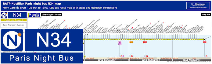
Paris Noctilien night bus N34 map with stops and transport connections
However, these maps and timetables show the RATP Noctilien N34 night bus line travelling between from Paris Gare de Lyon - Diderot through several different areas of the Paris region including Montreuil and Noisy-le-Grand to Torcy RER in ticket tariff zone 5. Yet to reach Bastille or leave the area after a night out, you would need the Ledru-Rollin - Faubourg Saint-Antoine night bus stop located on the Avenue Ledru-Rollin close to the Metro station of the same name, or alternatively, you could utilise the Daumesnil - Ledru-Rollin stop on the Avenue Daumesnil, which is only a short walk from Opera Bastille and the Square.
Paris night bus line N34 stops:
Gare de Lyon - Diderot, Gare de Lyon - Maison de la RATP, Gare de Lyon - Diderot, Daumesnil - Ledru-Rollin, Ledru-Rollin - Faubourg Saint-Antoine, Charonne - Keller, Basfroi, Voltaire - Leon Blum, Saint-Maur - Servan, Roguette - Pere Lachaise, Folie-Regnault - Chemin Vert, Auguste Metivier, Pere Lachaise, Muriers, Martin Nadaud, Gambetta, Hopital Tenon, Pelleport, Porte de Bagnolet, Echangeur de Bagnolet, General de Gaulle, Republique - Robespierre, Fraternite, Sorins, Marche, Croix de Chavaux - Rouget de Lisle, Victor Hugo, Mairie de Montreuil - Rouget de Lisle, Mairie de Montreuil, Centre Administratif, Lycee Jean Jaures, Danton, Edouard Branly, Nouvelle France, Acacia, Fort de Rosny, Saint-Exupery, Babeuf, Charles Delavacquerie, Le Morillon, Jules Guesde, Cimetiere de Vincennes, La Fontaine, Jean Mace, Pablo Picasso, Val de Fontenay RER, Val de Fontenay RER - Louison Bobet, Croix d'Eau, Avron, Jules Ferry, Jouleau, Neuilly-Plaisance RER, Centre Bus, Helene Boucher, Villebois - Mareuil, Foch - De Gaulle, Place de la Resistance, Rene Navier, Route de Neuilly, Noisy-le-Grand - Mont d'Est RER, Republique, Espace Michel Simon, Mairie de Noisy-le-Grand, Carrefour de Malnoue, Pointe de Gournay, Les Prevoyants, Les Rosiers, Place Churchill, Rond-Point des Pyramides, C.S.T.B. - Matteotti, Les Iris, Pointe de Champs, Mairie de Champs, Maison de Retraite, Les Quatre Paves, Jules Ferry, La Remise aux Fraises, Cite Scolaire, La Mogotte, Bel Air, Les Tilleuls, Mairie de Torcy, La Mare aux Marchais, Rue des Epinettes, Jacques Prevert, Rives de Maubuee, Salvador Allende, Cites Unies, Torcy RER.
Paris night bus line N34 main transport connections:
Metro Lines: 1, 2, 3, 3bis, 8, 9, 14. Train Lines: A, D, E, R. Tram Line: T3b. Bus Lines: N01, N02, N11, N16, N31, N32, N33, N35, N71, N130, N131, N132, N133, N134, N141, N142, N144.
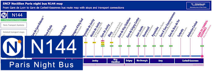
Paris Noctilien night bus N144 map with stops and transport connections
Although, here you have the maps and timetables for the Noctilien N144 night bus line that travels between Gare de Lyon and Gare de Corbeil-Essonnes and with stops at many train stations on route, not forgetting that this night bus goes to Paris Orly Airport, the nearest night bus stop to Bastille Square, otherwise known as Place de la Bastille, is the Gare de Lyon - Diderot stop on the Rue de Lyon, which is approximately 900 metres walk.
Paris night bus line N144 stops:
Gare de Lyon - Diderot - Rue de Lyon*, Place d'Italie - Place d'Italie, Porte d'Italie, Airport Orly 4 - Quai 4, Pyramide de Juvisy - Avenue F. Mitterrand***, Pyramide de Juvisy - Avenue de la Cour de France**, Mairie de Juvisy - Avenue de la Cour de France - Avenue F. Mitterrand, Gare de Juvisy - Place du Marechal Joffre, Blazy - Avenue du General de Gaulle, Gare de Viry-Chatillon - Avenue du General de Gaulle, Gare de Grigny Centre - Route de Grigny (Centre Cial), Jean Jaures - Route de Grigny, Daumesnil - Avenue de la Liberation, Pyramides - Boulevard des Champs-Elysees, Gare d'Evry Courcouronnes - Gare routiere basse d'Evry, Gare du Bras de Fer - Bd des Coquibus, Tarterets - Bd Jean Jaures, Ambroise Croizat - Boulevard Jean Jaures, Gare de Corbeil-Essonnes - Place Henri Barbusse.
* For Gare de l'Est change to the N01 or N02. ** Night bus stop served in direction of Corbeil-Essonnes. *** Night bus stop served in direction of Paris Gare de Lyon.
Paris night bus line N144 main transport connections:
Metro Lines: 1, 14. Train Lines: A, D, R, TGV. Bus Lines: N01, N02, N15, N22, N31, N32, N33, N34, N35, N130, N131, N132, N133, N134, N135.
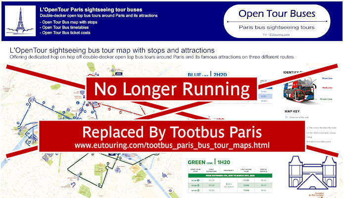
Paris Open Tour bus sightseeing tour map for Blue, Red and Green bus lines with stops and timetables
Yet you could also opt to enjoy Paris with a hop on hop off bus tour, and with 3 different routes with numerous stops, one of these is at the Place de la Bastille, and as you will see from the Open Tour maps and timetables, the Bastille bus stop is classed as number 42 on the Green line tour that stops at 8 Rue Saint-Antoine, which is by the corner of Rue des Tournelles, only a few metres from Bastille Square.
6: Notre-Dame - Visitor Centre 4 Rue du Petit Pont, 75005 40: Luxembourg - Pantheon - 4 Place Edmond Rostand, 75006 41: Pont de Sully - Ile Saint Louis - Face au 3 Boulevard Henri IV, 75005 42: Bastille - Rue Saint-Antoine - 8 Rue Saint-Antoine, 75004 43: Hotel de Ville - 48 bis, Rue de Rivoli, 75004 44: Centre Pompidou - Chatelet - 24 Boulevard Sebastopol, 75001 45: Centre Pompidou - Beaubourg - 25 Rue du Renard, 75004
Paris Open Tour bus sightseeing tour maps with stops and timetables:
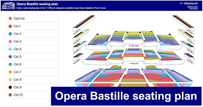
Opera Bastille seating plan and the 11 different categories
Here you can see an Opera Bastille seating plan, which shows the different balconies, galleries and tiers with the various seating categories that you can choose from, and with tickets varying in price depending upon the performance, you can see that the prime and most expensive are the Optima category, going through to Catergory 10 being located right at the back of the side galleries on the top level, so do bear this in mind when booking.