How to get to Le Duc des Lombards jazz club in Paris using public transport
The Jazz Club Le Duc des Lombards is a renowned cosy music venue in Paris playing host to many international musicians along with up and coming artists, with varied performances of different genres virtually every night of the year plus late night jam sessions, so below you can discover more about the venue along with how to get to Duc des Lombards using public transport including maps, timetables and more.
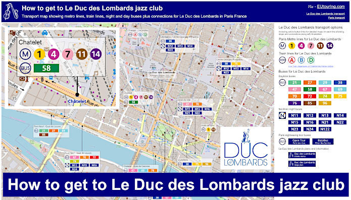
Le Duc des Lombards transport map of Metro lines, trains and bus lines with stops, connections and street plan
This first map shows the various transport options for Le Duc des Lombards Jazz Club including Metro, RER trains, buses and the Noctilien night buses that run when other transport has finished for the day, which are especially useful for a Friday and Saturday night being that this entertainment venue does not close until 4am.
How to get to Le Duc des Lombards public transport maps available:
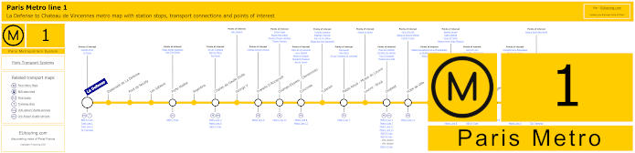
Paris Metro Line 1 map with stations, connections and points of interest
Here you can see the Metro line 1 maps travelling between La Defense by the Grande Arche and Chateau de Vincennes, and with many stops in between that provide transport connections such as Gare de Lyon train station, you will find that the Chatelet stop is the closest to Le Duc des Lombards Jazz Club in Paris.
Metro Line 1 stops:
La Defense, Esplanade de La Defense, Pont de Neuilly, Les Sablons, Porte Maillot, Argentine, Charles de Gaulle Etoile, George V, Franklin D Roosevelt, Champs-Elysees - Clemenceau, Concorde, Tuileries, Palais Royal - Musee du Louvre, Louvre - Rivoli, Chatelet, Hotel de Ville, Saint-Paul, Bastille, Gare de Lyon, Reuilly - Diderot, Nation, Porte de Vincennes, Saint-Mande, Berault, Chateau de Vincennes.
Metro line 1 main transport connections:
Metro Lines: 2, 4, 5, 6, 7, 8, 9, 11, 12, 13, 14. Train Lines: A, B, C, D, L, R, U. Tram Lines: T2, T3a, T3b.
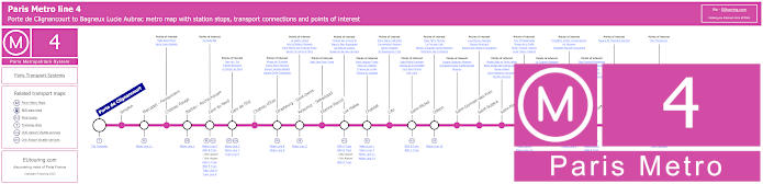
Paris Metro Line 4 map with stations, connections and points of interest
Whereas Metro line 4 travels from Porte de Clignancourt to Bagneux Lucie Aubrac also stopping at Chatelet for the Duc des Lombards at a distance of only around 200 metres walk, yet this metro line also stops at Gare du Nord train station where the Eurostar arrives in Paris.
Metro line 4 stops:
Porte de Clignancourt, Simplon, Marcadet - Poissonniers, Chateau Rouge, Barbes - Rochechouart, Gare du Nord, Gare de l'Est, Chateau d'Eau, Strasbourg - Saint-Denis, Reaumur - Sebastopol, Etienne Marcel, Les Halles, Chatelet, Cite, Saint-Michel, Odeon, Saint-Germain-des-Pres, Saint-Sulpice, Saint-Placide, Montparnasse - Bienvenue, Vavin, Raspail, Denfert-Rochereau, Mouton-Duvernet, Alesia, Porte d'Orleans, Mairie de Montrouge, Barbara, Bagneux Lucie Aubrac.
Metro line 4 main transport connections:
Metro Lines: 1, 2, 3, 5, 6, 7, 8, 9, 10, 11, 12, 13, 14. Train Lines: A, B, C, D, E, H, K, N, P. Tram Lines: T3a, T3b. Bus Line: OrlyBus.
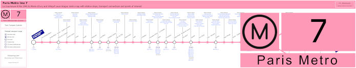
Paris Metro Line 7 map with stations, connections and points of interest
As you can see from the Paris Metro line 7 maps, this travels from La Courneuve - 8 Mai 1945 then branches off either to Mairie d'Ivry or Villejuif - Louis Aragon and this is how to get to Opera Garnier, along with many other attractions including the Jazz Club, Le Duc des Lombards via the Chatelet metro station.
Metro line 7 stops:
La Courneuve - 8 Mai 1945, Fort d'Aubervilliers, Aubervilliers - Pantin - Quatre Chemins, Porte de la Villette, Corentin Cariou, Crimee, Riquet, Stalingrad, Louis Blanc, Chateau-Landon, Gare de l'Est, Poissonniere, Cadet, Le Peletier, Chaussee d'Antin - La Fayette, Opera, Pyramides, Palais Royal - Musee du Louvre, Pont Neuf, Chatelet, Pont Marie, Sully - Morland, Jussieu, Place Monge, Censier - Daubenton, Les Gobelins, Place d'Italie, Tolbiac, Maison Blanche, Porte d'Italie, Porte de Choisy, Porte d'Ivry, Pierre et Marie Curie, Mairie d'Ivry, Le Kremlin-Bicetre, Villejuif - Leo Lagrange, Villejuif - Paul Vaillant-Couturier, Villejuif - Louis Aragon.
Metro line 7 main transport connections:
Metro Lines: 1, 2, 3, 4, 5, 6, 7bis, 8, 9, 10, 11, 14. Train Lines: A, B, D, E, P. Tram Lines: T1, T3a, T3b, T7. Bus Line: RoissyBus.
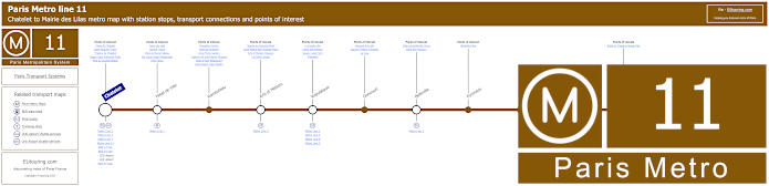
Paris Metro Line 11 map with stations, connections and points of interest
Whereas the maps for the Paris Metro line 7 show this actually starting from the transport hub of Chatelet, going through to Mairie des Lilas, with several metro stations on route including Republique with its many transport connections.
Metro line 11 stops:
Chatelet, Hotel de Ville, Rambuteau, Arts et Metiers, Republique, Goncourt, Belleville, Pyrenees, Jourdain, Place des Fetes, Telegraphe, Porte des Lilas, Mairie des Lilas.
Metro line 11 main transport connections:
Metro Lines: 1, 2, 3, 3bis, 4, 5, 7, 7bis, 8, 9, 14. Train Linea: A, B, D. Tram Line: T3b.
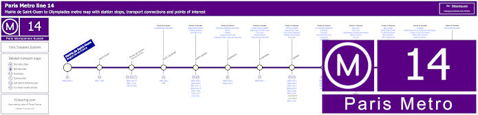
Paris Metro Line 14 map with stations, connections and points of interest
Yet the Metro line 14 goes from Gare Saint-Lazare train station to Olympiades with stops in between including Madeleine, Chatelet, Bibliotheque Francois Mitterrand and Bercy with this latter being how to get to Bercy Arena now also known as AccorHotels Arena Paris.
Metro line 14 stops:
Mairie de Saint-Ouen (Region Ile-de-France), Saint-Ouen, Porte de Clichy (Tribunal de Paris), Pont Cardinet, Saint-Lazare, Madeleine, Pyramides, Chatelet, Gare de Lyon, Bercy, Cour Saint-Emilion, Bibliotheque Francois Mitterrand, Olympiades.
Metro line 14 main transport connections:
Metro Lines: 1, 3, 4, 6, 7, 8, 9, 11, 12, 13. Train Lines: A, B, C, D, E, J, L, R. Tram Lines: T3a Walk, T3b.
Some attractions close to Metro line 14 stops:
Square Marcel Pagnol, Chapelle Expiatoire, Cafe Marco Polo, Place de la Madeleine and Church, Fauchon, Hediard, La Maison de la Truffe, Fragonard Theatre Musee des Capucines, La Belle Epoque Cabaret, Palais Royal and Petit Canon, The Louvre, Tuileries Gardens, Musee des Arts Decoratifs , Place de Chatelet, Saint-Jacques Tower, Dans la Noir Restaurant, Fontaine des Innocents, River Seine, Le Train Bleu Restaurant, Cafe Barge, Les Docks, l'Improviste Jazz Club, Le Playtime, Le VIP Paris, Bercy Park, POPB Arena, Cinematheque Francaise and Museum, Dame de Canton, Nix Nox, Bercy Village, Yitzhak Rabin Garden, Fairground Museum, Bercy Pavilions, Chai 33 Restaurant, Le Batofar, Bibliotheque Francois Mitterand Forest Garden, Globes of Louis XIV Museum, Allee Arthur Rimbaud, Bateau El Alamein, Cyprian Norwid Garden.
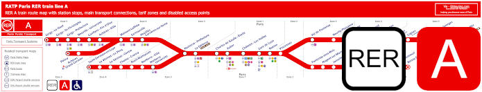
Red RER A train line map showing station stops, line branches, transport connections and zones
Here you can see the maps for the RER A train line that goes from the centre of Paris at place stations such as Charles de Gaulle Etoile by the Arc de Triomphe and Chatelet - Les Halles, which is only a walk of approximately 300 metres from Le Duc des Lombards Jazz Club. But as you can see, this has various branches going into the Paris region and one will take you to Marne la Vallee - Chessy for getting to Disneyland Paris, and you can see live train arrivals and departures via the link below.
Paris RER A train line stops:
Cergy le Haut*, Cergy Saint-Christophe, Cergy Prefecture, Neuville Universite, Conflans Fin d’Oise, Acheres Ville, Maisons-Laffitte, Sartrouville, Houilles - Carrieres sur Seine, Nanterre Prefecture, La Defense (Grande Arche), Charles de Gaulle Etoile, Auber, Chatelet Les Halles, Paris Gare de Lyon, Nation, Vincennes, Val de Fontenay, Neuilly Plaisance, Bry sur Marne, Noisy le Grand - Mont d’Est, Noisy Champs, Noisiel, Lognes, Torcy, Bussy Saint-Georges, Val d’Europe, Marne la Vallee - Chessy (Parcs Disneyland)*, Poissy*, Acheres - Grand Cormier, Saint-Germain en Laye*, Le Vesinet Le Pecq, Le Vesinet Centre, Chatou Croissy, Rueil Malmaison, Nanterre Ville, Nanterre University, Fontenay sous Bois, Nogent sur Marne, Joinville le Pont, Saint-Maur - Creteil, Le Parc de Saint-Maur, Champigny, La Varenne - Chennevieres, Sucy Bonneuil, Boissy Saint-Leger*.
* Terminus Points.
Paris RER A train line main transport connections:
Metro Lines: 1, 2, 3, 4, 6, 7, 8, 9, 11, 14. Train Lines: B, D, E, J, L, R, U, TGV. Tram Lines: T2, 13. Bus Lines: 393, RoissyBus, TVM (14).
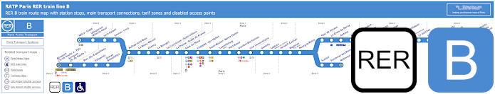
Blue RER B train line map showing station stops, line branches, transport connections and zones
Although the RER B train line is the most popular choice for how to get to Charles de Airport from Paris and is one of the most widely used train lines for getting to sports and entertainment venues around Paris, not forgetting its direct link with Eurostar to London at Paris Gare du Nord. Yet just like above, for how to get to Le Duc des Lombards you would need the Chatelet - Les Halles train station.
Paris RER B train line stops:
Mitry–Claye*, Villeparisis - Mitry-le-Neuf, Vert-Galant, Sevran–Livry, Aulnay-sous-Bois, Le Blanc-Mesnil, Drancy, Le Bourget, La Courneuve - Aubervilliers, La Plaine - Stade de France, Gare du Nord, Chatelet - Les Halles, Saint-Michel - Notre-Dame, Luxembourg, Port-Royal, Denfert-Rochereau, Cite Universitaire, Gentilly, Laplace, Arcueil - Cachan, Bagneux, Bourg-la-Reine, Sceaux, Fontenay-aux-Roses, Robinson*, Aeroport Charles de Gaulle 2 - TGV*, Aeroport Charles de Gaulle 1, Parc des Expositions, Villepinte, Sevran - Beaudottes, Parc de Sceaux, La Croix de Berny, Antony (Orly), Fontaine-Michalon, Les Baconnets, Massy - Verrieres, Massy - Palaiseau, Palaiseau, Palaiseau - Villebon, Lozere (Ecole Polytechnique), Le Guichet, Orsay–Ville, Bures-sur-Yvette, La Hacquiniere, Gif-sur-Yvette, Courcelle-sur-Yvette, Saint-Remy-les-Chevreuse*.
* Terminus Points.
Paris RER B train line main transport connections:
Metro Lines: 1, 2, 4, 5, 6, 7, 10, 11, 14. Train Lines: A, C, D, E, H, K, TGV, CDG Val, OrlyVal. Tram Lines: T3a, T4, T11. Bus Lines: TVM (14), OrlyBus, RoissyBus.
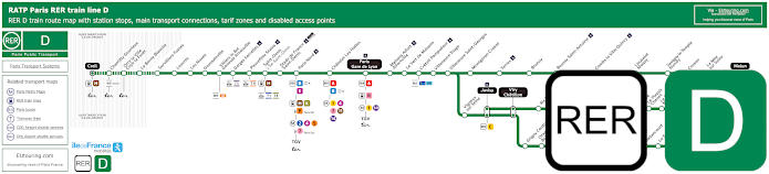
Green RER D train line map showing station stops, line branches, transport connections and zones
As you can see from the maps, with its various transfer points, connections and terminuses, the RER D train line also goes from the centre of Paris at three main train stations including Chatelet - Les Halles to the outskirts of Paris and its region, Ile de France, so bear in mind the different ticket tariff zones applicable on the route.
Paris RER D train line stops:
Creil*, Chantilly - Gouvieux, Orry-la-Ville - Coye-la-Foret, La Borne Blanche, Survilliers - Fosses, Louvres, Les Noues, Goussainville, Villiers-le-Bel - Gonesse - Arnouville, Garges - Sarcelles, Pierrefitte - Stains, Saint-Denis, Stade de France - Saint-Denis, Paris Gare du Nord, Chatelet - Les-Halles, Paris Gare de Lyon, Maisons-Alfort - Alfortville, Le Vert de Maisons, Creteil - Pompadour, Villeneuve - Triage, Villeneuve - Saint-Georges, Montgeron-Crosne, Yerres, Brunoy, Boussy - Saint-Antoine, Combs-la-Ville - Quincy, Lieusaint-Moissy, Savigny-le-Temple - Nandy, Cesson, Le Mee-sur-Seine, Melun*, Vigneux-sur-Seine, Juvisy**, Viry Cahatillon**, Ris - Orangis, Grand-Bourg, Evry - Val de Seine, Grigny Centre, Orangis - Bois de l'Epine, Evry - Courcouronnes (Centre), Le Bras de Fer (Evry Genepole), Corbeil - Essonnes**, Essonnes - Robinson, Villabe, Le Plessis - Chenet, Le Coudray - Montceaux, Saint-Fargeau, Ponthierry - Pringy, Poissise-le-Roi, Vosves, Melun**, Moulin Galant, Mennecy, Ballancourt, La Ferte-Alais, Boutigny, Maisse, Buno Gironville, Boigneville, Malesherbes*.
* Terminus points. ** RER D Transfer points.
Paris RER D train line main transport connections:
Metro Lines: 1, 2, 4, 5, 7, 11, 14. Train Lines: A, B, C, E, H, K, P, R, TGV, TER. Tram Lines: T1, T5, T8, T11. Bus Lines: 20, 393, Senlis, TVM (14), Tzen 1.
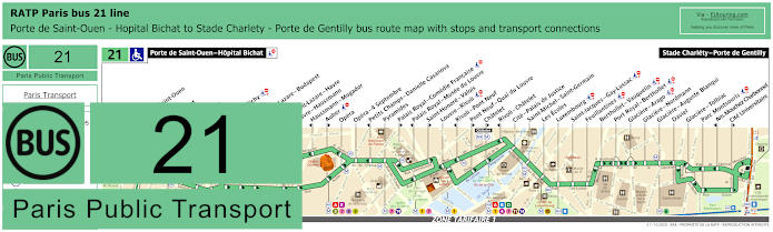
RATP Paris bus line 21 with stops, connections and street plan
This shows the RATP Paris bus line 21 that goes between Porte de Saint-Ouen - Hopital Bichat and Stade Charlety - Porte de Gentilly, although as you can see from the street maps and timetables, there are several bus stops for a particular direction of travel, so depending upon which way you wish to go, you would need either the Chatelet stop or the Rivoli - Chatelet bus stop for Le Duc des Lombards.
Paris bus line 21 stops:
Porte de Saint-Ouen - Hopital Bichat, Porte de Saint-Ouen, Navier, Guy Moquet, Davy, La Fourche, Ganneron, Place de Clichy, Liege, Gare Saint-Lazare - Budapest**, Trinite*, Gare Saint-Lazare - Havre**, Havre - Haussmann**, Haussmann - Mogador*, Auber**, Opera, Opera - 4 Septembre, Petits Champs - Danielle Casanova*, Pyramides, Palais Royal - Comedie Francaise**, Palais Royal - Musee du Louvre*, Saint-Honore - Valois**, Louvre - Rivoli, Rivoli - Pont Neuf*, Pont Neuf - Quai du Louvre**, Chatelet**, Rivoli - Chatelet*, Cite - Palais de Justice, Saint-Michel - Saint-Germain, Les Ecoles, Luxembourg, Saint-Jacques - Gay-Lussac, Feuillantines, Berthollet - Vauquelin, Port Royal - Berthollet, Glaciere - Arago, Glaciere - Nordmann, Glaciere - Auguste Blanqui, Daviel, Glaciere - Tolbiac, Parc Montsouris, Am. Mouchez Charbonnel*, Cite Universitaire**, Stade Charlety - Porte de Gentilly.
* Stop served in direction of Porte de Saint-Ouen - Hopital Bichat. ** Stop served in direction of Stade Charlety - Porte de Gentilly.
Paris bus line 21 main transport connections:
Metro Lines: 1, 2, 3, 4, 6, 7, 8, 9, 10, 11, 12, 13, 14. Train Lines: A, B, D, E, J, L. Tram Lines: T3a, T3b.
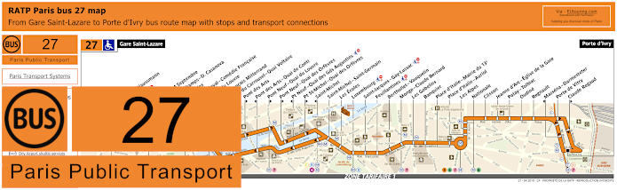
RATP Paris bus line 27 with stops, connections and street plan
Here we have the Paris bus line 27 that travels between Gare Saint-Lazare train station and Porte d'Ivry, which has bus stops on route at popular tourist attractions like Musee du Louvre, and to reach Le Duc des Lombards Jazz Club you would need the Pont Neuf - Quai du Louvre bus stop, which is approximately 750 metres walk, although please bear in mind the direction of travel, as you can see from the maps with their timetables.
Paris bus line 27 stops:
Gare Saint-Lazare, Havre - Haussmann, Auber, Opera, Opera - 4 Septembre, Petits Champs - D. Casanova*, Pyramides, Palais-Royal - Comedie Francaise, Musee du Louvre*, Quai Francois Mitterrand**, Pont du Carrousel - Quai Voltaire*, Pont des Arts**, Pont des Arts - Quai de Conti*, Pont Neuf - Quai du Louvre**, Pont Neuf - Quai des Orfevres**, Pt Neuf - Quai des Gds Augustins*, Pt St-Michel - Quai des Orfevres**, Saint-Michel*, Saint-Michel - Saint-Germain, Les Ecoles, Luxembourg, Saint-Jacques - Gay-Lussac, Feuillantines, Berthollet - Vauquelin, Monge - Claude Bernard, Les Gobelins, Banquier, Place d’Italie - Mairie du 13e, Place d’Italie - Auriol, Les Alpes, Nationale, Clisson, Jeanne d’Arc - Eglise de la Gare, Patay - Tolbiac, Oudine, Regnault, Massena - Darmesteter*, Porte de Vitry, Claude Regaud**, Porte d'Ivry.
* Stop served in direction of Gare Saint-Lazare. ** Stop served in direction of Porte d'Ivry.
Paris bus line 27 main transport connections:
Metro Lines: 1, 3, 4, 5, 6, 7, 8, 9, 12, 13, 14. Train Lines: A, B, C, E, L, J. Tram Line: T3a.
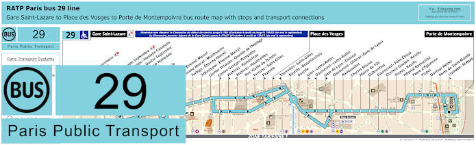
RATP Paris bus 29 map with stops, connections and street plan
The Paris bus line 29 goes from Porte de Montempoivre to Place des Vosges and then further on to Gare Saint-Lazare train station, but please take note of the bus maps and timetables carefully as you will see that the latter part of the bus route does not operate until a Sunday evening compared to normal hours all other days, and to get to the Duc des Lombards you would need this section of the line and the Sebastopol - Etienne Marcel bus stop then walking down the Boulevard de Sebastopol for approximately 500 metres.
Paris bus line 29 stops:
Gare Saint-Lazare, Havre - Haussmann, Auber, Opera, Opera - Quatre Septembre, Petits Champs - Danielle Casanova**, Richelieu - Quatre Septembre*, Bibliotheque Nationale**, Bourse*, Mairie du 2e*, Victoires, Louvre - Etienne Marcel**, Etienne Marcel - Montmartre, Turbigo - Etienne Marcel, Sebastopol - Etienne Marcel, Grenier St-Lazare - Quartier de l’Horloge, Centre Georges Pompidou*, Archives - Rambuteau*, Archives - Haudriettes**, Rue Vieille du Temple, Turenne - Saint-Gilles**, Payenne*, Place des Vosges*, Tournelles-Saint-Gilles**, Bastille - Beaumarchais, Bastille, Lyon - Ledru-Rollin*, Daumesnil - Ledru-Rollin**, Gare de Lyon - Diderot*, Daumesnil - Diderot (Gare de Lyon), Rambouillet, Charles Bossut, Mairie du 12e, Dubrunfaut, Daumesnil - Felix Eboue, Docteur Goujon - Reuilly, Picpus - Reuilly, Hopital Rothschild, Fabre d’Eglantine, Picpus, Docteur Netter, Porte de Saint-Mande, J. Lemaitre - M. Ravel*, Porte de Montempoivre.
* Served in direction of Porte de Montempoivre. ** Served in direction of Gare Saint-Lazare.
Paris bus line 29 main transport connections:
Metro Lines: 1, 3, 4, 5, 6, 7, 8, 9, 11, 12, 13, 14. Train Lines: A, D, E, J, L, R. Tram Line: T3a.
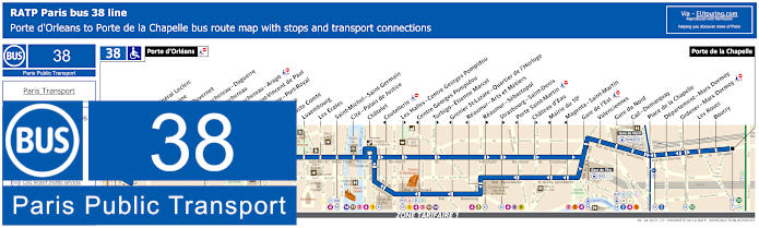
RATP Paris bus line 38 with stops, connections and street plan
Yet the bus line 38 also run by RATP in Paris goes from Porte d'Orleans to Porte de la Chapelle with numerous stops and transport connections on route, with the closest bus stop to this Jazz Club being Les Halles - Centre Georges Pompidou on the Boulevard de Sebastopol or you have the Chatelet stop at Place du Chatelet by the historical Tour Saint-Jacques Gothic tower a similar distance away in the opposite direction.
Paris bus line 38 stops:
Porte d'Orleans, Alesia - General Leclerc, Alesia - Maine*, Mouton - Duvernet, Denfert-Rochereau - Daguerre**, Denfert-Rochereau*, Denfert-Rochereau - Arago, Hopital Saint-Vincent de Paul, Observatoire - Port-Royal, Val de Grace, Auguste Comte, Luxembourg, Les Ecoles, Saint-Michel - Saint-Germain, Cite - Palais de Justice, Chatelet, Coutellerie*, Les Halles - Centre Georges Pompidou**, Centre Georges Pompidou*, Turbigo - Etienne Marcel**, Grenier St-Lazare - Quartier de l’Horloge*, Reaumur - Arts et Metiers*, Reaumur - Sebastopol**, Strasbourg - Saint-Denis**, Porte Saint-Martin*, Chateau d’Eau**, Mairie du 10e*, Magenta - Saint-Martin*, Gare de l’Est, Valenciennes, Gare du Nord, Cail-Demarquay, Place de la Chapelle, Departement-Marx Dormoy, Ordener - Marx Dormoy, Les Roses, Boucry, Porte de la Chapelle.
*Stops served in direction of Porte d'Orleans. ** Stops served in direction of Porte de la Chapelle.
Paris bus line 38 main transport connections:
Merto Lines: 1, 2, 3, 4, 5, 6, 7, 8, 9, 11, 12, 14. Train Lines: A, B, C, D, E, H, K, P. Tram Lines: T3a, T3b.
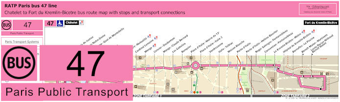
RATP Paris bus line 47 with stops, connections and street plan
Whereas you will find that the bus line 47 starts its route at Chatelet, also by Tour Saint-Jacques on the Avenue Victoria and this Paris bus route travels through to Fort du Kremlin-Bicetre, which is on the outskirts of Paris in ticket tariff zone 2 as you can see from the bus 47 maps and timetables.
Paris bus line 47 stops:
Chatelet, Cite - Palais de Justice*, Cite - Parvis Notre-Dame**, Notre-Dame - Quai de Montebello*, Lagrange*, Petit Pont**, Dante**, Maubert - Mutualite, Cardinal Lemoine, Monge, Censier - Daubenton, Monge - Claude Bernard, Les Gobelins, Banquier, Place d’Italie - Mairie du 13e, Place d’Italie - Italie 2, Vandrezanne, Italie - Tolbiac, Maison Blanche, Porte d’Italie, Porte d’Italie - Helene Boucher, Roger Salengro - Fontainebleau, Convention - Fontainebleau, Le Kremlin-Bicetre - Metro, Hopital du Kremlin-Bicetre, Barnufles - La Piscine, Benoit Malon - Martinets**, Lycee Darius Milhaud - Benoit Malon**, Fort du Kremlin-Bicetre.
* Stop served in direction of Chatelet. ** Stop served in direction of Fort du Kremlin-Bicetre.
Paris bus line 47 main transport connections:
Metro Lines: 1, 4, 5, 6, 7, 10, 11, 14. Train Lines: A, B, C, D. Tram Line: T3a.
RATP Paris bus line 58 with stops, connections and street plan
Again going from the outskirts of Paris at Vanves - Lycee Michelet, the RATP bus line 58 goes through to Chatelet with the terminus point being at the Place du Chatelet only a few metres from the Metro station itself and a short walk to Le Duc des Lombards, but please take note of the bus maps as there are many stops which are direction dependant.
Paris bus line 58 stops:
Vanves - Lycee Michelet, Carrefour Albert Legris***, Jean Jaures - Jean Bleuzen, Adolphe Pinard**, Pont de la Vallee, Porte de Vanves, Porte Didot - Lycee Raspail*, Porte de Chatillon*, Colonel Monteil**, Didot**, Jean Moulin*, Hopitaux Broussais et Saint-Joseph**, Hopital Notre-Dame de Bon Secours*, Alesia - Didot**, Alesia - Les Plantes*, Pernety**, Rue Benard*, Chateau**, Chateau - Mairie du 14e*, Losserand - Maine, Gaite***, Gare Montparnasse***, Montparnasse - Rue du Depart, Montparnasse - Cinemas*, Vavin, Brea - Notre-Dame-des-Champs*, Notre-Dame-des-Champs**, Raspail - Fleurus**, Fleurus**, Guynemer - Vavin* ***, Musee du Luxembourg***, Senat, Theatre de l'Odeon* ***, Saint-Germain - Odeon***, Mazarine*, Saint-Andre des Arts** ***, Pont Neuf - Quai des Gds Augustins, Saint-Michel**, Cite - Palais de Justice*, Pont Neuf - Quai du Louvre**, Chatelet - Q. de Gesvres**, Chatelet.
* Stop served in the direction of Vanves - Lycee Michelet. ** Stop served in the direction of Chatelet. *** Not accessible to those with reduced mobility.
Paris bus line 58 main transport connections:
Metro Lines: 1, 4, 6, 7, 10, 11, 12, 13, 14. Train Lines: A, B, C, D, N. Tram Line: T3a.
RATP Paris bus 67 map with stops, connections and street plan
However, here we have the Paris bus line 67 that travels between Palais Royal - Musee du Louvre and Stade Charlety - Porte de Gentilly and as you can see from the bus maps and timetables, there are many bus stops that are direction dependant, so you may need the Chatelet stop, or the Chatelet - Quai de Gesvres stop both within easy walking distance of the Duc des Lombards Jazz Club.
Paris bus line 67 stops:
Palais Royal - Musee du Louvre, Louvre - Rivoli, Rivoli - Pont-Neuf, Pont Neuf - Quai du Louvre, Chatelet, Chatelet - Quai de Gesvres, Hotel de Ville, Rue Vieille du Temple - Mairie du 4e, Pont Louis-Philippe, Pont Marie, Ile Saint-Louis, Sully - Morland, Pont de Sully - Quai de Bethune, Institut du Monde Arabe, Jussieu, Cuvier - Jardin des Plantes, Buffon - La Mosquee, Saint-Marcel - Jeanne d’Arc, Jenner - Jeanne d’Arc, Rubens - Ecole des Arts et Metiers, Place d’Italie - Mairie du 13e, Place d’Italie - Bobillot, Place d’Italie - Blanqui, Moulin des Pres, Verlaine, Bobillot - Tolbiac, Rungis, Amiral Mouchez, Stade Charlety - Porte de Gentilly.
Paris bus line 67 main transport connections:
Metro Lines: 1, 4, 5, 6, 7, 10, 11, 14. Train Lines: A, B, D. Tram Line: T3a.
RATP Paris bus line 69 with stops, connections and street plan
As you can see from the bus line 69 maps and timetables this particular route is how to get to the Eiffel Tower via the terminus Champ de Mars bus stop along with many other tourist attractions such as the Musee du Louvre, Bastille, etc on its journey through to Gambetta - Japon. But to reach this Jazz Club entertainment venue, just like above, you would need either the Chatelet bus stop or the Chatelet - Quai de Gesvres stop depending upon your direction of travel.
Paris bus line 69 stops:
Champ de Mars, Rapp - La Bourdonnais, Champ de Mars - La Bourdonnais*, Bosquet - Grenelle*, Bosquet - Saint-Dominique**, Saint-Pierre du Gros Caillou, Invalides - La Tour-Maubourg*, La Tour-Maubourg - Saint-Dominique**, Esplanade des Invalides, Bourgogne, Grenelle - Bellechasse*, Solferino - Bellechasse, Musee d’Orsay*, Rue du Bac - Rene Char, Pont Royal - Quai Voltaire**, Henry de Montherlant*, Pont du Carrousel - Quai Voltaire*, Pont Royal**, Quai Francois Mitterrand**, Musee du Louvre*, Palais Royal - Musee du Louvre*, Pont des Arts**, Louvre - Rivoli* ***, Pont Neuf - Quai du Louvre**, Rivoli - Pont Neuf*, Chatelet*, Chatelet - Quai de Gesvres**, Hotel de Ville, Eglise Saint-Gervais**, Rue Vieille du Temple - Mairie du 4e*, Rue de Jouy** ***, Saint-Paul, Birague, Bastille - Rue Saint-Antoine, Bastille - Roquette**, Beaumarchais*, Breguet - Sabin**, Richard Lenoir*, Commandant Lamy**, Popincourt, Chemin Vert - Parmentier*, Voltaire - Leon Blum, Saint-Maur - Servan***, Roquette - Pere Lachaise, Folie-Regnault - Chemin Vert* ***, Pere Lachaise**, Auguste Metivier*, Muriers, Martin Nadaud***, Gambetta, Gambetta - Japon.
* Stop served in direction of Champ de Mars. ** Stop served in direction of Gambetta - Japon. *** Not accessible to those with reduced mobility.
Paris bus line 69 main transport connections:
Metro Lines: 1, 2, 3, 3bis, 4, 5, 7, 8, 9, 11, 12, 13, 14. Train Lines: A, B, C, D.
RATP Paris bus line 70 with stops, connections and route plan
You will find that the RATP bus line 70 travels from Hotel de Ville, which is the Paris City Hall, through to Porte de Passy and on a Monday to Friday the route goes further on to Suresness - De Gaulle, yet like many Paris bus lines, certain stops are direction dependant and for Le Duc des Lombards the nearest bus stop called Chatelet - Quai des Gesvres is only served in the direction of Hotel de Ville.
Paris bus line 70 stops:
Suresnes - De Gaulle***, Mairie de Suresnes** ***, Henri IV** ***, Henri Sellier - Pont de Suresnes** ***, Rue des Bourets - Pont de Suresnes* ***, Pont de Suresnes** ***, Les Moulins - Camping***, Allee de l'Esperance***, Les Cascades***, Porte de Passy, Louis Boilly**, Avenue Ingres*, Chaussee de la Muette, Ranelagh*, Rodin*, Les Vignes - Boulainvilliers RER**, Assomption - Radio France**, La Fontaine - Radio France*, Place du Docteur Hayem - Radio France, Pont de Grenelle - Maurice Bourdet, Pont de Grenelle - Place Fernand Forest, Charles Michels, Violet, Felix Faure, Peclet, Mairie du 15e, Vaugirard - Favorites**, Cambronne - Lecourbe*, Cambronne - Vaugirard**, Volontaires - Lecourbe*, Volontaires - Vaugirard**, Sevres - Lecourbe, Pasteur - Lycee Buffon**, Hopital des Enfants Malades, Vaneau - Saint-Romain, Bac - Saint-Placide, Sevres - Babylone, Michel Debre, Eglise Saint-Sulpice*, Bonaparte - Saint-Germain**, Seine - Buci**, Saint-Germain - Odeon*, Saint Andre des Arts**, Mazarine*, Pont Neuf - Quai des Grands Augustins, Saint-Michel, Cite - Palais de Justice, Pt Neuf - Q du Louvre, Chatelet - Quai des Gesvres**, Chatelet*, Hotel de Ville.
* Served in Direction of Suresnes - De Gaulle or Porte de Passy. ** Served in direction of Paris Hotel de Ville. *** Only served on a Monday to Friday.
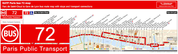
RATP Paris bus 72 map with stops, connections and street plan
Then there is the bus line 72 that goes from Parc de Saint-Cloud to Gare de Lyon with numerous stops on its bus route for how to get to the Grand Palais and other tourist attractions, but as before, please take note of the street maps and timetables as the two bus stops needed for getting to the Duc des Lombards Jazz Club are Rivoli - Chatelet or Chatelet - Quai des Gesvres depending upon your direction of travel.
Paris bus line 72 stops:
Parc de Saint-Cloud, La Colline, Pont de Saint-Cloud - Rive Gauche, Pont de Saint-Cloud - Albert Kahn, Rhin et Danube - Metro, Ancienne Mairie, Route de la Reine - Jean Jaures, Victor Hugo, La Tourelle, Porte de Saint-Cloud, Porte de Saint-Cloud - Murat, Versailles - Chardon Lagache, Versailles - Exelmans, Victorien Sardou, Wilhem, Pont Mirabeau, Degas, Radio France - Pont de Grenelle, Radio France, Lamballe - Ankara, Pont de Bir-Hakeim, Le Notre*, Pont d’Iena, Musee d’Art Moderne - Palais de Tokyo, Alma - Marceau, Palais de la Decouverte, Grand Palais, Cours la Reine - Chevaux de Marly*, Concorde*, Concorde - Quai des Tuileries**, Pont de Solferino - Quai des Tuileries**, Castiglione*, Pont Royal**, Pyramides - Tuileries*, Quai Francois Mitterrand**, Palais Royal - Musee du Louvre*, Louvre - Rivoli*, Pont des Arts**, Pont Neuf - Quai du Louvre**, Rivoli - Pont Neuf*, Rivoli - Chatelet*, Chatelet - Quai de Gesvres**, Hotel de Ville, Rue Vieille du Temple - Mairie du 4e*, Pont Louis Philippe**, Pont Marie*, Sully Morland, Port Henri IV**, Port de L'Arsenal*, Quai de la Rapee*, Pont Charles De Gaulle, Van Gogh**, Gare de Lyon.
* Served in direction of Parc de Saint-Cloud. ** Served in direction of Gare de Lyon.
Paris bus line 72 main transport connections:
Metro Lines: 1, 4, 5, 6, 7, 8, 9, 10, 11, 12, 13, 14. Train Lines: A, B, C, D, R.
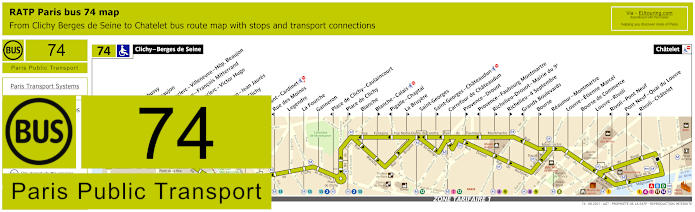
RATP Paris bus line 74 with stops, connections and street plan
Although the RATP bus line 74 travels from ticket tariff zone 2 at Clichy - Berges de Seine through to the major transport hub of Chatelet, and it is this terminus point you would need for the Jazz Club, Le Duc des Lombards, but on route there are other entertainment venues within walking distance of bus stops including how to get to the Casino de Paris music hall via the Blanche stop.
Paris bus line 74 stops:
Clichy - Berges de Seine, Claude Debusy**, Hopital Beaujon, General Leclerc - Villeneuve - Hop. Beaujon, Republique - Francois Mitterrand, General Leclerc - Victor Hugo, Curton, Victor Hugo - Jean Jaures, Porte de Clichy, Boulay, Brochant - Cardinet, Rue des Moines*, Legendre, La Fourche, Ganneron, Place de Clichy - Caulaincourt*, Place de Clichy**, Blanche, Blanche - Calais**, Pigalle - Chaptal*, La Bruyere**, Saint-Georges, Saint-Georges - Chateaudun**, Carrefour de Chateaudun, Provence - Drouot**, Provence - Faubourg Montmartre*, Richelieu - Drouot - Mairie du 9e**, Richelieu - 4 Septembre**, Grands Boulevards*, Bourse**, Reaumur - Montmartre, Louvre - Etienne Marcel, Bourse de Commerce, Louvre - Rivoli, Rivoli - Pont Neuf*, Pont Neuf - Quai du Louvre**, Rivoli - Chatelet*, Chatelet.
* Stop served in direction of Clichy - Berges de Seine. ** Stop served in direction of Chatelet.
Paris bus line 74 main transport connections:
Metro Lines: 1, 2, 3, 4, 7, 8, 9, 11, 12, 13, 14. Train Lines: A, B, C, D. Tram Line: T3b.
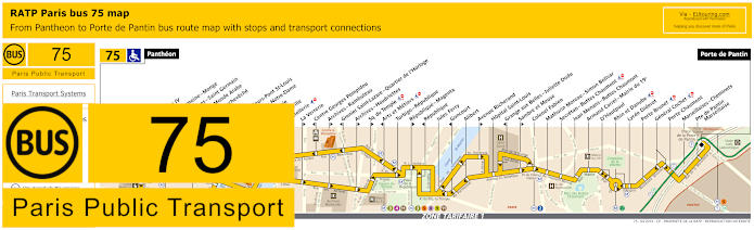
RATP Paris bus line 75 with stops, connections and street plan
Here we have the maps and timetables for Paris bus line 75 going from the Pantheon to Porte de Pantin, which is one of the transport options for getting to Zenith Paris music venue at Parc de la Villette, yet for Le Duc des Lombards Jazz Club you would need the Coutellerie stop if going towards the Pantheon, or a little further and you have the Hotel de Ville stop going in the opposite direction.
Paris bus line 75 stops:
Pantheon, Lycee Henri IV**, Cardinal Lemoine - Monge**, Saint-Jacques - Saint Germain*, Institut du Monde Arabe*, Pont de l’Archeveche**, Petit Pont*, Quai aux Fleurs - Pont St-Louis**, Cite - Parvis Notre-Dame*, Pont d’Arcole**, Hotel de Ville**, Coutellerie*, La Verrerie**, Centre Georges Pompidou*, Archives - Rambuteau**, Grenier Saint-Lazare - Quartier de l’Horloge*, Archives - Haudriettes*, Square du Temple**, Arts et Metiers*, Turbigo - Republique, Republique - Magenta**, Republique*, Jules Ferry, Goncourt*, Alibert, Avenue Richerand**, Hopital Saint-Louis, Grange aux Belles - Juliette Dodu*, Sambre et Meuse**, Colonel Fabien, Mathurin Moreau - Simon Bolivar, Secretan - Buttes Chaumont, Jean Menans - Buttes Chaumont, Armand Carrel - Mairie du 19e, D’Hautpoul, Rhin et Danube, Lycee Diderot, Porte Brunet, General Cochet, Porte Chaumont, Marseillaises - Cheminets, Porte de Pantin - Marseillaise, Porte de Pantin.
* Stop served in direction of Pantheon. ** Stop served in direction of Porte de Pantin.
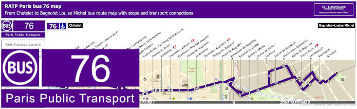
RATP Paris bus line 76 with stops, connections and street plan
Whereas the RATP bus line 76 travels to Bagnolet - Louise Michel from the Chatelet transport hub and bus stop with the same name that is located on the Avenue Victoria by the Saint-Jacques Tower in Paris, which is the stop you would need for the Paris Jazz Club, Le Duc des Lombards, which is also one of the transport options for getting to Bastille, etc.
Paris bus line 76 stops:
Chatelet, Hotel de Ville, Eglise Saint-Gervais, R. Vieille du Temple - Mairie du 4e, Rue de Jouy, Saint-Paul, Birague, Bastille - Rue Saint-Antoine, Bastille - Faubourg Saint-Antoine, La Boule Blanche, Ledru-Rollin - Faubourg Saint-Antoine, Charonne - Keller, Faidherbe, Charonne - Voltaire, Charonne - Philippe Auguste, Charonne - Bagnolet, La Reunion, Pyrenees - Bagnolet, Pelleport - Bagnolet, Porte de Bagnolet, Echangeur de Bagnolet, General de Gaulle, Gallieni - Metro, Centre de Sante, La Poste, Mairie de Bagnolet, Marie-Anne Colombier, Eglise de Bagnolet, Pierre Curie, Descartes, Les Malassis, Stalingrad, Girardot, Bagnolet - Louise Michel.
Paris bus line 76 main transport connections:
Metro Lines: 1, 2, 3, 4, 5, 7, 8, 9, 11, 14. Train Lines: A, B, D. Tram Line: T3b.
RATP Paris bus line 85 with stops, connections and street plan
As per several other Paris bus routes, the RATP bus line 85 converges on the Chatelet transport hub, going to Saint-Ouen - Les Docks, and as you will see from the maps and timetables, this has many bus stops only served in a particular direction, yet it is the terminus of Chatelet that you would need in order to walk to Le Duc des Lombards Jazz Club, which is located at the Place du Chatelet only around 170 metres from this music venue in Paris.
Paris bus line 85 stops:
Saint-Ouen - Les Docks, Parvis des Bateliers, Mairie de Saint-Ouen - Republique, Ernest Renan, Eugene Lumeau - Les Ecoles, Paul Bert, Marche aux Puces, Michelet - Rosiers, Porte de Clignancourt, Albert Kahn, Mairie du 18e - Jules Joffrin, Marcadet**, Eugene Sue*, Custine - Ramey**, Labat*, Muller, Barbes - Rochechouart**, Rochechouart - Clignancourt, Condorcet - Trudaine*, Trudaine**, Maubeuge - Rochechouart*, La Tour d’Auvergne**, Chateaudun - Lamartine**, Cadet*, Provence - Faubourg Montmartre*, Provence - Drouot**, Richelieu - Drouot - Mairie du 9e**, Grands Boulevards*, Richelieu - Quatre Septembre**, Reaumur - Montmartre, Bourse**, Louvre - Etienne Marcel, Bourse de Commerce, Louvre - Rivoli, Rivoli - Pont Neuf*, Pont Neuf - Quai du Louvre**, Chatelet.
* Stop served in direction of Saint-Ouen - Les Docks. ** Stop served in direction of Chatelet, Paris.
Paris bus line 85 main transport connections:
Metro Lines: 1, 2, 3, 4, 7, 8, 9, 11, 12, 13, 14. Train Lines: A, B, D. Tram Line: T3b.
RATP Paris bus line 96 with stops, connections and street plan
Yet the bus line 96 travels from Porte des Lilas - Metro through to Gare Montparnasse train station with numerous transport connections on route and as you can see from the bus street maps and timetables, you will either need the Chatelet - Quai de Gesvres or the Coutellerie bus stop for how to get to Le Duc des Lombards Jazz Club, depending upon your direction of travel.
Paris bus line 96 stops:
Gare Montparnasse, Montparnasse - Rue de l’Arrivee*, Montparnasse**, Rennes - Littre, Rennes - Saint-Placide, Rennes - d’Assas, Michel Debre, Eglise Saint-Sulpice*, Bonaparte - Saint-Germain**, Seine - Buci**, Saint-Germain - Odeon, Saint-Michel*, Saint-Michel - Saint-Germain**, Cite - Palais de Justice, Chatelet - Quai de Gesvres**, Coutellerie*, Hotel de Ville, Eglise Saint-Gervais**, Rue de Jouy**, Rue Vieille du Temple - Mairie du 4e*, Saint-Paul, Place des Vosges, Saint-Claude, Bretagne, Jean-Pierre Timbaud*, Oberkampf - Filles du Calvaire**, Jean-Pierre Timbaud - Richard Lenoir*, Oberkampf - Richard Lenoir**, Parmentier - Republique**, Parmentier*, Maison des Metallos*, Saint-Maur - Jean Aicard**, Couronnes*, Belleville - Menilmontant, Julien Lacroix, Henri Chevreau, Pyrenees - Menilmontant, Menilmontant - Pelleport, Saint-Fargeau, Piscine des Tourelles, Port des Lilas - Metro.
* Stop served in direction of Gare Montparnasse. ** Stop served in direction of Porte des Lilas - Metro.
Paris bus line 96 main transport connections:
Metro Lines: 1, 2, 3, 3bis, 4, 5, 6, 7, 8, 9, 10, 11, 12, 13, 14. Train Lines: A, B, C, D, N. Tram Line: T3b.
Paris Noctilien night bus N11 map with stops and transport connections
The Noctilien are night buses that goes from Paris to the outskirts of the Paris region that operate when other transport has finished for the night, which is ideal if you are enjoying a late night jam session at the Duc des Lombards Paris music venue, and here you can see Noctilien line N11 travelling between Pont de Neuilly and Chateau de Vincennes, with the Chatelet stop or Chatelet - Qua de Gesvres bus stop being the ones required for this Jazz Club.
Paris night bus line N11 stops:
Pont de Neuilly, Maurice Barres, Les Graviers, Les Sablons, Marche, Andre Maurois*, Porte Maillot - Palais des Congres*, Palais des Congres**, Porte Maillot**, Argentine, Charles de Gaulle - Etoile - Grande Armee, Charles de Gaulle - Etoile - Champs-Elysees, George V, La Boetie - Champs-Elysees, Rond-Point des Champs-Elysees, Champs-Elysees - Clemenceau, Concorde - Cours la Reine, Concorde*, Concorde - Quai des Tuileries**, Castiglione*, Pont de Solferino - Quai des Tuileries**, Pyramides - Tuileries*, Pont Royal**, Palais Royal - Musee du Louvre*, Quai Francois Mitterrand**, Louvre - Rivoli*, Pont des Arts**, Rivoli - Pont Neuf*, Pont Neuf - Quai du Louvre**, Chatelet - Quai de Gesvres**, Chatelet*, Hotel de Ville, Rue Vieille du Temple - Mairie du 4e*, Rue de Jouy**, Saint-Paul, Birague, Bastille - Rue Saint-Antoine, Bastille, Lyon - Ledru-Rollin, Gare de Lyon - Diderot, Daumesnil - Diderot, Hopital Saint-Antoine, Reuilly - Diderot, Pierre Bourdan, Nation - Diderot, Nation - Trone, Marsoulan, Pyrenees - Docteur Netter, Porte de Vincennes, Saint-Mande - Tourelle**, Aubert, Berault, Vignerons, Avenue du Chateau, Chateau de Vincennes.
* In direction of Pont de Neuilly. ** In direction of Chateau de Vincennes.
Paris night bus line N11 main transport connections:
Paris Noctilien night bus N12 map with stops and transport connections
Whereas these maps and timetables show the Noctilien N12 bus line which travels between Pont de Sevres and Romainville - Carnot and this night bus route has a stop at Chatelet for getting to Le Duc des Lombards, plus it has transport connections to other Paris night buses such as at Republique and Gare Montparnasse train station.
Paris night bus line N12 stops:
Pont de Sevres, Billancourt, Marcel Sembat, Rene Descartes, Henri Martin, Porte de Saint-Cloud, Porte de Saint-Cloud - Murat, Versailles - Chardon Lagache, Versailles - Exelmans, Victorien Sardou, Wilhem, Pont Mirabeau, Degas, Radio France - Pont de Grenelle, Pont de Grenelle - Maurice Bourdet, Pont de Grenelle - Pl. Fernand Forest, Charles Michels, Avenue Emile Zola, Cambronne, Sevres - Lecourbe, Pasteur - Lycee Buffon, Pasteur - Falguiere, Armorique - Musee Postal, Gare Montparnasse, Montparnasse - Rue de l’Arrivee, Montparnasse, Rennes - Littre, Rennes - Saint-Placide, Rennes - D'Assas, Michel Debre, Bonaparte - Saint-Germain, Saint-Germain-des-Pres, Jacob, Seine - Buci, Pont du Carrousel - Quai Voltaire, Saint-Germain - Odeon, Pont des Arts - Quai de Conti, Pont Neuf - Quai des Grands Augustins, Saint-Michel, Saint-Michel - Saint-Germain, Cite - Palais de Justice, Chatelet, Les Halles - Centre Georges Pompidou, Centre Georges Pompidou, Turbigo - Etienne Marcel, Grenier St-Lazare - Quartier de l’Horloge, Reaumur - Sebastopol, Reaumur - Arts et Metiers, Arts et Metiers, Square du Temple, Turbigo - Republique, Republique, Ferry - Lenoir, Parmentier - Republique, Saint-Maur - Jean Aicard, Jules Ferry, Goncourt, Belleville - Menilmontant, Vouronnes, Belleville, Pyrenees - Belleville, Jourdain, Pixerecourt, Pelleport - Belleville, Porte des Lilas, Les Bruyeres, Mairie des Lilas, Rue de Noisy-le-Sec, Paul de Kock, Joseph Depinay, Gagarine, Cimetiere de Bagnolet, Floreal, Les Noyers, Mairie de Romainville, Gabriel Husson, Romainville - Carnot.
Paris night bus line N12 main transport connections:
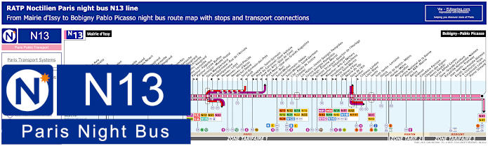
Paris Noctilien night bus N13 map with stops and transport connections
Yet the Noctilien night bus line N13 goes between Mairie d'Issy and Bobigny - Pablo Picasso, which is a way of getting to the Grande Halle La Villette via the Porte de Pantin stop for its many varied shows and exhibitions, yet for the Duc des Lombards Jazz Club you would require the Chatelet night bus stop located on the Avenue Victoria by Saint-Jacques Tower.
Paris night bus line N13 stops:
Mairie d'Issy, Victor Hugo, Freres Voisin*, Colonel Pierre Avia*, Maison de Retraite**, Severine**, Louis Armand*, Porte d'Issy**, Suzanne Lenglen*, Balard*, Firmin Gillot**, Balard - Lecourbe*, Lycee Louis Armand*, Duranton*, Vaugirard - Croix Nivert**, Hopital de Vaugirard**, Convention - Lecourbe*, Convention - Vaugirard**, Abbe Groult, Mairie du 15e*, Vaugirard - Favorites**, Cambronne - Lecourbe*, Cambronne - Vaugirard**, Volontaires - Lecourbe*, Volontaires - Vaugirard**, Sevres - Lecourbe*, Pasteur - Falguiere**, Pasteur - Lycee Buffon*, Armorique - Musee Postal, Gare Montparnasse, Montparnasse - Rue de l'Arrivee*, Montparnasse**, Rennes - Littre, Rennes - Saint-Placide, Rennes - d'Assas, Michel Debre, Saint-Germain-des-Pres*, Jacob*, Bonaparte - Saint-Germain**, Pont du Carrousel - Quai Voltaire*, Pont des Arts - Quai Conti*, Pont Neuf - Quai des Grands Augustins*, Seine - Buci**, Saint-Michel*, Saint-Germain - Odeon**, Saint-Michel - Saint-Germain**, Cite - Palais de Justice, Chatelet, Les Halles - Centre Georges Pompidou**, Centre Georges Pompidou*, Turbigo - Etienne Marcel**, Grenier St-Lazare - Quartier de l'Horloge*, Reaumur - Sebastopol**, Reaumur - Arts et Metiers*, Strasbourg - Saint-Denis**, Porte Saint-Martin*, Chateau d'Eau**, Mairie du 10e*, Gare de l'Est, Verdun**, Chateau Landon, Louis Blanc, Jaures, Jean Jaures - Lorraine, Ourcq, Porte de Pantin - Metro, Hoche - Metro, Montgolfier, Centre National de la Danse, Pantin RER - Mairie, Delizy, Diderot, Cimetiere Parisien, Chemin des Vignes, Henri Gautier, Lycee Alfred Costes, Gare - Grande Ceinture, Escradille Normandie-Niemen - Jean Jaures - Tramway, Escadrille Normandie-Niemen - Paul Vaillant-Couturier - Tram, Lieutenant Lebrun, Pierre Semard, Bobigny - Pablo Picasso.
* Only served in the direction of Mairie d'Issy. ** Only served in the direction of Bobigny - Pablo Picasso.
Paris night bus line N13 main transport connections:
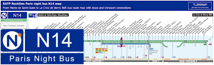
Paris Noctilien night bus N14 map with stops and transport connections
The Paris Noctilien N14 night bus also stops at Chatelet for this Jazz club music venue, and there are two separate bus stops depending upon your direction of travel, which are located only a few metres apart from each other, with one going in the direction of Mairie de Saint-Ouen and the other in the direction of La Croix de Berny RER.
Paris night bus line N14 stops:
Mairie de Saint-Ouen - Republique, Ernest Renan, Garibaldi, Kleber, Gerard de Nerval, Angelique Compoint, Camille Flammarion, Porte de Clignancourt, Simplon, Marcadet - Poissonniers, Chateau Rouge, Barbes - Rochechouart, Magenta - Mauberge - Gare du Nord, La Fayette - Magenta - Gare du Nord, Gare de l'Est, Magenta - Saint Martin*, Chateau d'Eau**, Mairie du 10e*, Porte Saint-Martin*, Strasbourg - Saint-Denis**, Reaumur - Sebastopol**, Reaumur - Arts et Metiers*, Turbigo - Etienne Marcel**, Grenier St-Lazare - Quartier de l'Horloge*, Les Halles - Centre Georges Pompidou**, Centre Georges Pompidou*, Chatelet, Cite - Palais de Justice, Saint-Michel - Saint-Germain, Les Ecoles, Luxembourg, Auguste Comte, Val du Grace, Observatoire - Port Royal, Hopital Saint-Vincent de Paul, Denfert-Rochereau -Arago, Denfert-Rochereau*, Denfert-Rochereau - Daguerre**, Mouton - Duvernet, Alesia - Maine*, Alesia - General Leclerc, Porte d'Orleans, Porte d'Orleans - Metro*, Gabriel Peri, Leon Gambetta, Vache Noire, Jean-Marin Naudin, Gustave Courbet - Metro, Grange Ory, Carnot - Aristide Briand, Marcel Bonnet, Pont Royal - RER, Cite Jardins, Place de la Resistance - Charles de Gaulle, Rue du 8 mai 1945, Bourg-la-Reine RER*, Condorcet - Mairie - RER**, Petit Chambord - Lycee Lakanal, Les Cottages, La Fontaine, Normandie, General de Gaulle - Croix de Berny*, La Croix de Berny RER.
* Bus stop served in direction of La Croix Berny RER. ** Bus stop served in direction of Mairie de Saint-Ouen - Republique.
Paris night bus line N14 main transport connections:
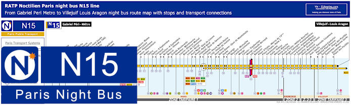
Paris Noctilien night bus N15 map with stops and transport connections
As with many of the Paris bus lines, some stops are direction dependant, so as you can see on the night bus maps and timetables for the Noctilien bus line N15, you would need either the Chatelet - Quai de Gesvres night bus stop going in the direction of Villejuif - Louis Aragon, or the Chatelet stop if you are travelling in the direction of Gabriel Peri - Metro after enjoying the late night music sessions at Le Duc des Lombards.
Paris night bus line N15 stops:
Gabriel Peri - Metro, Place Voltaire, Leon Blum, Landy - Martre*, Mairie de Clichy, Jaures - Barbusse**, Barbusse - Martre*, Victor Hugo - Jean Jaures**, Victor Hugo - 8 Mai 1945*, Porte de Clichy, Boulay, Brochant - Cardinet, Rue des Moines*, Legendre, La Fourche, Ganneron, Place de Clichy, Bucarest, Europe, Gare Saint-Lazare - Rome**, Gare Saint-Lazare, Rome - Haussmann*, Auber, Opera, Opera - 4 Septembre**, Choiseul*, Richelieu - 4 Septembre**, Richelieu - Drouot*, Bourse**, Grands Boulevards*, Reaumur - Montmartre, Louvre - Etienne Marcel, Bourse de Commerce, Louvre - Rivoli, Pont Neuf - Quai du Louvre**, Rivoli - Pont Neuf*, Chatelet - Quai des Gesvres**, Chatelet*, Cite - Parvis Notre-Dame**, Cite - Palais de Justice*, Petit Pont**, Notre-Dame - Quai de Montebello*, Dante**, Lagrange*, Maubert - Mutualite, Cardinal Lemoine, Monge, Censier - Daubenton, Monge - Claude Bernard, Les Gobelins, Banquier, Place d'Italie - Mairie du 13eme, Place d'Italie - Italie 2, Vandrezanne, Italie - Tolbiac, Maison Blanche, Porte d'Italie, Porte d'Italie - Helene Boucher, Roger Salengro - Fontainebleau, Convention - Fontainebleau, Le Kremlin-Bicetre Metro, Dauphin - Anatole France, Henri Barbusse, Dispensaire Danielle Casanova, Jean Jaures**, Paul Vaillant-Couturier - Hopital Paul Brousse*, Guynemer - Place des Fusilles**, Guynemer - Maxime Gorki, Guynemer - Place des Fusilles*, Villejuif - Louis Aragon.
* Stop served in the direction of Gabriel Peri - Metro. ** Stop served in the direction of Villejuif - Louis Aragon.
Paris night bus line N15 main transport connections:
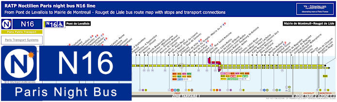
Paris Noctilien night bus N16 map with stops and transport connections
Although, here you can see that the Nocitien night bus line N16 travels from Pont de Levallois to Mairie de Montreil - Rouget de Lisle with its numerous night bus stops and transport connections on route, which is also an option for how to get to Bastille or from this lively area of Paris, yet for the Duc des Lombards Jazz Club, as above you would need the Chatelet or Chatelet Quai de Gesvres stop.
Paris night bus line N16 stops:
Pont de Levallois, Picasso*, Vaillant - Couturier*, Anatole France**, Mairie de Levallois*, Porte de Courcelles*, Porte de Champerret, Pereire - Le Chatelier*, Pereire - Villiers**, Europe, Gare Saint-Lazare - Rome**, Gare Saint-Lazare, Rome - Haussmann*, Havre - Haussmann**, Auber, Opera, Opera - 4 Septembre**, Choiseul*, Richelieu - 4 Septembre**, Richelieu - Drouot*, Bourse**, Grands Boulevards*, Reaumur - Montmartre, Louvre - Etienne Marcel, Bourse de Commerce, Louvre - Rivoli, Rivoli - Pont Neuf*, Pont Neuf - Quai du Louvre**, Chatelet - Quai de Gesvres**, Chatelet*, Hotel de Ville, Rue Vieille du Temple - Mairie du 4e*, Rue de Jouy**, Saint-Paul, Birague, Bastille - Rue Saint-Antoine, Bastille, Lyon - Ledru-Rollin, Gare de Lyon - Diderot, Daumesnil - Ledru-Rollin, Ledru-Rollin - Faubourg St-Antoine, Charonne - Keller, Basfroi, Voltaire - Leon Blum, Saint-Maur - Servan, Roquette - Pere Lachaise, Folie Regnault - Chemin Vert*, Auguste Metivier*, Pere Lachaise**, Muriers*, Martin Nadaud*, Gambetta*, Hopital Tenon*, Pelleport, Porte de Bagnolet, Echangeur de Bagnolet**, General de Gaulle, Republique - Robespierre, Fraternite, Sorins, Marche, Croix de Chavaux - Rouget de Lisle, Victor Hugo, Mairie de Montreuil - Rouget de Lisle.
* Served in direction of Pont de Levallois. ** Served in direction of Mairie de Montreuil - Rouget de Lisle.
Paris night bus line N16 main transport connections:
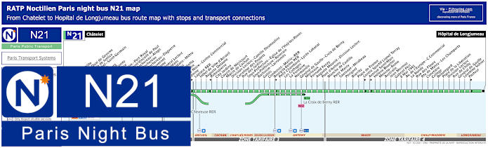
Paris Noctilien night bus N21 map with stops and transport connections
Whereas the Noctilien N21 Paris night bus line actually has a terminus point of Chatelet on the Avenue Victoria, and as you can see from the maps with timetables, this travels through the Paris region to ticket tariff zone 4 and the terminus point of Hopital de Longjumeau with various transport connections to other night bus lines on route.
Paris night bus line N21 stops:
Chatelet, Hotel de Ville, Chatelet - Quai de Gesvres, Cite - Palais de Justice, Saint-Michel - Saint-Germain, Les Ecoles, Luxembourg, Auguste Comte, Val de Grace, Observatoire - POrt Royal, Hopital Saint-Vincent de Paul, Denfert-Rochereau - Arago, Denfert-Rochereau, Denfert-Rochereau - Daguerre, Mouton-Duvernet, Alesia - Maine, Alesia - General Leclerc, Porte d'Orleans, Porte d'Orleans - Metro, Gabriel Peri, Leon Gambetta, Vache Noire, Vache Noire - Centre Commercial, Lenine, Laplace RER, Hotel de Vill d'Arcueil, Auguste Delaune, Robespierre, Cite Jardins, Cousin de Mericourt, Mairie de Cachan, Division Leclerc - Camille Desmoulins, Carrefour des Poulets, Rue des Jardins, Sous-Prefecture - Eglise de l'Hay-les'Roses, Sous-Prefecture - Roseraie, Barbusse - Larroumes, Galois, Condorcet - Mairie - RER, Bourg-la-Reine RER, Petit Chambord - Lycee Lakanal, Les Cottages, La Fontaine, Normandie, General de Gaulle - Croix de Berny, Morteaux, Fernand Fenzy, Auguste Mounie - Division Leclerc, Pont d'Antony, Blanche de Castille, Petit Massy, Saussaye - Mirabeau, Perigord, Biarritz, Place de France, Centre Sportif Lionel Terray, Avenue Saint-Marc, Helene Boucher, Moscou - Rome, Australie, Jean Mermoz, Gabriel Peri, 8 Mai 1945, Avenue de l'Europe - Centre Commercial, La Bonde, Rue des Fleurs, Route de Massy - Les Champarts, Cimetiere, College, Beauregard, Place de la Liberation, Division Leclerc, Rue de Chilly, General de Gaulle, Leontine Sohier, Pasteur, Hopital de Longjeumeau.
Paris night bus line N21 main transport connections:
Metro Lines: 1, 4, 6, 7, 11, 14. Train Lines: A, B, D. Tram Line: T3a. Bus Lines: N01, N02, N11, N12, N13, N14, N15, N16, N22, N23, N24, N62, N66, N122, TVM (14).
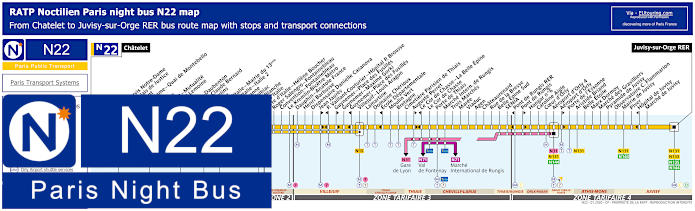
Paris Noctilien night bus N22 map with stops and transport connections
Just like the night bus line above, the Noctilien N22 line goes from or to Chatelet, which is the stop you would need for the Duc des Lombards Jazz Club. Travelling to the outskirts of Paris through different communes to Juvisy-sur-Orge RER, this is one of the ways for how to get to Orly Airport as well, but please take note of the different ticket tariff zones you may need to pay for.
Paris night bus line N22 stops:
Chatelet, Cite - Parvis Notre Dame*, Cite - Palais de Justice**, Petit Pont*, Notre-Dame - Quai de Montebello**, Dante*, Lagrange**, Maubert - Mutualite, Cardinal Lemoine, Monge, Censier - Daubenton, Monge - Claude Bernard, Les Gobelins, Banquier, Place d'Italie - Mairie du 13eme, Place d'Italie - Italie 2, Vandrezanne, Italie - Tolbiac, Maison Blanche, Porte d'Italie, Porte d'Italie - Helene Boucher, Roger Salengro - Fontainebleau, Convention - Fontainebleau, Le Kremlin-Bicetre Metro, Dauphin - Anatole France, Henri Barbusse, Dispensaire Danielle Casanova, Jean Jaures*, Paul Vaillant-Couturier - Hopital P. Brousse**, Guynemer - Place des Fusilles*, Gynemer - Maxime Gorki, Gynemer - Place des Fusilles**, Villejuif - Louis Aragon, Lamartine, Domaine Cherioux, Ecole Departmentale**, Moulin Vert, Bretagne, Cimetiere Parisien de Thiais, Auguste Perret*, Le Cor de Chasse - La Belle Epine**, Le Cor de Chasse, Porte de Thiais, Marche International de Rungis, Trois Marches, Maree, Viaduc, Agen, Chateaurenard, Rue de la Bresse, Belle Epine Sud, SENIA, Pont de Rungis RER**, Pont de Rungis*, Hangar No 6, Caroline Aigle, Coeur d'Orly, Aeroport d'Orly 4, Aeroport d'Orly*, Porte de l'Essonne, Aristide Briand, Belle Etoile, Marx Dormoy, Marche des Gravilliers, Pyramide de Juvisy, Observatoire C. Flammarion, Mairie de Juvisy, Piver, Hopital de Juvisy**, Marche de Juvisy, Juvisy-sur-Orge RER.
* Served in the direction of Juvisy-sur-Orge RER. ** Served in the direction of Chatelet.
Paris night bus line N22 main transport connections:
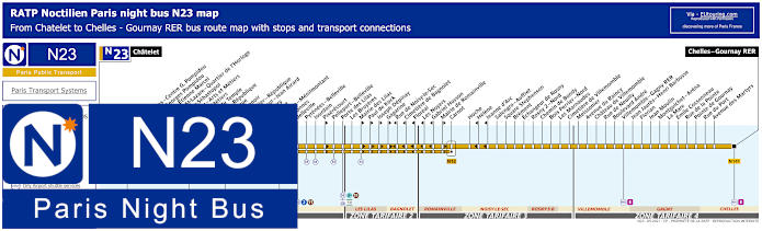
Paris Noctilien night bus N23 map with stops and transport connections
Also with a terminus point of Chatelet by the Place du Chatelet, this Noctilien N23 night bus line travels through to Chelles Gournay RER with various transport connection points on its route such as Republique, and like other night buses it goes from Paris through different communes, or areas, including Les Lilas, Bagnolet, Noisy-le-Sec and Villemomble, etc.
Paris night bus line N23 stops:
Chatelet, Les Halles - Centre Georges Pompidou, Centre Georges Pompidou, Turbigo - Etienne Marcel, Grenier St-Lazare - Quartier d'Horloge, Reaumur-Sebastepol, Reaumur - Arts et Metiers, Arts et Metiers, Square du Temple, Turbigo - Republique, Republique, Ferry - Lenoir, Parmentier - Republique, Saint-Maur - Jean Aicard, Jules Ferry, Goncourt, Belleville - Menilmontant, Couronnes, Belleville, Pyrenees - Belleville, Jourdain, Pixerecourt, Pelleport - Belleville, Porte des Lilas, Les Bruyeres, Mairie des Lilas, Paul de Kock, Joseph Depinay, Gagarine, Rue de Noisy-le-Sec, Cimetiere de Bagnolet, Floreal, Les Noyers, Gabriel Husson, Mairie de Romainville, Carnot, Hoche, Helene, Jeanne d'Arc, Salengro - Auffret, Square Stephenson, Brement, Echangeur de Rosny, Rosny 2 - Nord, Chemin de Bondy, Bois - Perrier - Nord, Les Marnaudes, Cimetiere de Villemomble, Meissonier, Avenue du Raincy, Chateau de Villemomble, Rue de Neuilly, Boulevard Andre, Villemomble - Gagny RER, Jean Jaures - Henri Barbusse, Florian, Jean Moulin, Montguichet - Arena, La Mare, Emile Cossonneau, Rue de la Pointe, Pointe de Gournay, Rue du Port, Avenue des Martyrs, Chelles - Gourney RER.
Paris night bus line N23 main transport connections:
Metro Lines: 1, 2, 3, 3bis, 4, 5, 7, 8, 9, 11, 14. Train Lines: A, B, D, E. Tram Line: T3b. Bus Lines: N01, N02, N11, N12, N13, N14, N15, N16, N122, N141, N142.
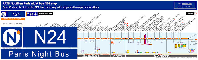
Paris Noctilien night bus N24 map with stops and transport connections
However, the Noctilien night bus line N24 travels from Sartrouville RER through to Chatelet where it terminates at Place du Chatelet by the Boulevard de Sebastopol and Saint-Jacques Tower, which will get you within easy walking distance of Le Duc des Lombards Jazz Club, and this is also an option for getting to the Palais des Congres, which is also another events venue in Paris.
Paris night bus line N24 stops:
Satrouville RER, Poste, Stalingrad, Jean Mermoz, Voltaire, Edouard Vaillant, Eglise, Picardie, Charles de Gaulle, Quatre Chemins, Rue de Chatou, Clemenceau, Condorcet, Val Notre-Dame, La Berthie, Albert 1er, Place des Droits de l'Homme, La Grace de Dieu, Pont de Bezons, Parc Pierre Lagravere, Victor Basch, Jacqueline Auriol, Gare de La Garenne-Colombes, La Garenne-Colombes - Charlebourg, Nordmann, Les Fauvelles, Dieppe, Faubourg de l'Arche, Caron, La Defense, Boieldieu**, Gallieni**, Gambetta*, Bellini**, Alsace*, Pont de Neuilly - Rive Gauche, Pont de Neuilly - Metro, Maurice Barres, Les Graviers, Les Sablons, Marche, Andre Maurois*, Porte Maillot - Palais de Congres*, Palais de Congres**, Porte Maillot**, Argentine, Charles de Gaulle - Etoile - Grande Armee, Charles de Gaulle - Etoile - Champs-Elysees, George V, La Boetie - Champs-Elysees, Rond-Point des Champs-Elysees, Champs-Elysees - Clemenceau, Concorde - Cours la Reine, Concorde*, Concorde - Quai des Tuileries**, Castiglione*, Pont de Solferino - Quai des Tuileries**, Pyramides - Tuileries*, Pont Royal**, Palais Royal - Musee du Louvre*, Quai Francois Mitterrand**, Pont des Arts**, Louvre - Rivoli*, Rivoli - Pont Neuf*, Pont Neuf - Quai du Louvre**, Chatelet - Quai de Gesvres**, Chatelet.
* Stop served in direction of Sartrouville RER. ** Stop served in direction of Chatelet.
Paris night bus line N24 main transport connections:
Metro Lines: 1, 2, 4, 6, 7, 8, 9, 11, 12, 14. Train Lines: A, B, C, D, J, L, U. Tram Line: T2. Bus Lines: N01, N02, N11, N12, N13, N14, N15, N16, N21, N22, N23, N122, N153.
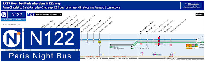
Paris Noctilien night bus N122 map with stops and transport connections
But the Noctilien N122 night bus line travels between Saint-Remy-les-Chevreuse RER and Chatelet for Le Duc des Lombards, where this night bus terminates at Avenue Victoria by the Theatre de la Ville at Place du Chatelet, and although travelling a distance through different tariff zones, there are only 17 night bus stops on route including the Porte d'Orleans and Observatoire - Port Royal stops.
Paris night bus line N122 stops:
Saint-Remy-les-Chevreuse RER, 11 Novembre - Courcelle-sur-Yvette RER, Gif-sur-Yvette RER, Bures-sur-Yvette RER - Universite, Mairie des Ulis - Place de la Liberte, Rond-Point de Mondetour, Mairie - Hopital - Orsay RER*, Place de la Republique - Orsay RER*, Place des Suisses, Palaiseau - Villebon RER, Edouard Branly - Palaiseau RER, Massy - Palaiseau RER, Porte d'Orleans Metro*, Porte d'Orleans*, Denfert-Rochereau - Arago, Observatoire - Port Royal, Luxembourg, Saint-Michel - Saint-Germain, Chatelet.
* Night bus stop only served in a specific direction.
Paris night bus line N122 main transport connections:
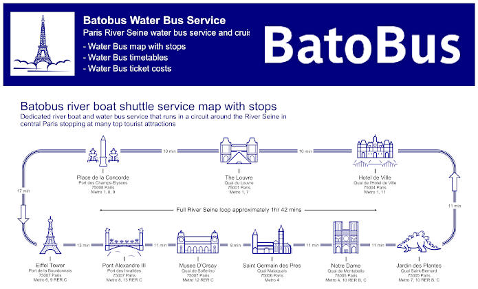
Paris Batobus map with river stops, timetables and ticket prices
Yet you will discover that the Batobus is in fact a water bus offering a hop on and hop off service up and down the River Seine, which is very popular with tourists as you see the sights from a different perspective and can get on and off the boats as much as you like with a day ticket. The docking stations are at key locations along the river including the Hotel de Ville stop, although, bear in mind that due to being at quays along the banks of the River Seine, these are not accessible to those with reduced mobility or wheelchair users, except for the Eiffel Tower Batobus water bus stop.
Batobus River Seine stops with attractions:
Eiffel Tower - Port de la Bourdonnais, Pont Alexandre III - Port des Invalides, Musee D'Orsay - Quai de Solferino, Saint Germain des Pres - Quai Malaquais, Notre Dame - Quai de Montebello, Jardin des Plantes - Quai Saint-Bernard, Hotel de Ville - Quai de l'Hotel de Ville, The Louvre - Quai du Louvre, Place de la Concorde - Port des Champs-Elysees.
Batobus main transport connections:
Metro lines 1, 4, 6, 7, 8, 9, 10, 11, 12 and 13 RER B and C
Batobus ticket prices:
Adult One Day Pass €17.00 Adult Two Day Pass €19.00 Child One Day Pass (aged 3-15 years) €8.00 Child Two Day Pass (aged 3-15 years) €10.00 Child (aged -3 years) FREE
Batobus water bus maps, timetables and ticket prices available:
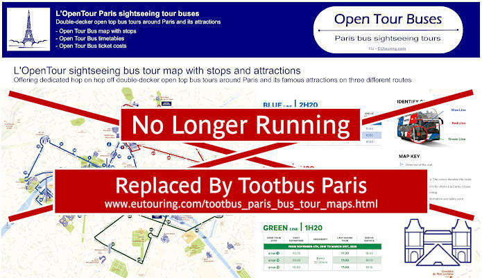
Paris Open Tour bus sightseeing tour map for Blue, Red and Green bus lines with stops and timetables
Although, you also have another sightseeing bus tour company called Open Tour that offer a hop on and hop off service at numerous locations throughout Paris, being able to utilise 3 different bus routes to see numerous tourist attractions like Bastille, the famous cabaret venue Moulin Rouge, the impressive Louvre Museum, etc. Yet for the Duc des Lombards and other attractions in this area you would need the Green Route and Stop 44 called Centre Pompidou - Chatelet at 24 Boulevard Sebastopol, or Stop 45 Centre Pompidou - Beaubourg, which is located 25 Rue du Renard, 75004.
6: Notre-Dame - Visitor Centre 4 Rue du Petit Pont, 75005 40: Luxembourg - Pantheon - 4 Place Edmond Rostand, 75006 41: Pont de Sully - Ile Saint Louis - Face au 3 Boulevard Henri IV, 75005 42: Bastille - Rue Saint-Antoine - 8 Rue Saint-Antoine, 75004 43: Hotel de Ville - 48 bis, Rue de Rivoli, 75004 44: Centre Pompidou - Chatelet - 24 Boulevard Sebastopol, 75001 45: Centre Pompidou - Beaubourg - 25 Rue du Renard, 75004
Paris Open Tour bus sightseeing tour maps with stops and timetables:
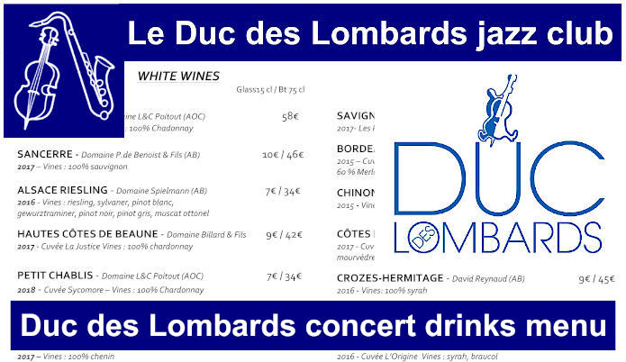
Duc des Lombards concert menu of beverages, drinks, beers, wines, and cocktails served
Opening at 7pm for a performance at 7:30pm then with another concert at 9:45pm by the same artist on a Monday to Saturday, which vary in cost from around €29 upwards, here you can see the bar menu and its varied drinks on offer along with platters for those of you who would like a snack during one of these Duc des Lombards concerts often featuring internationally renowned Jazz musicians.
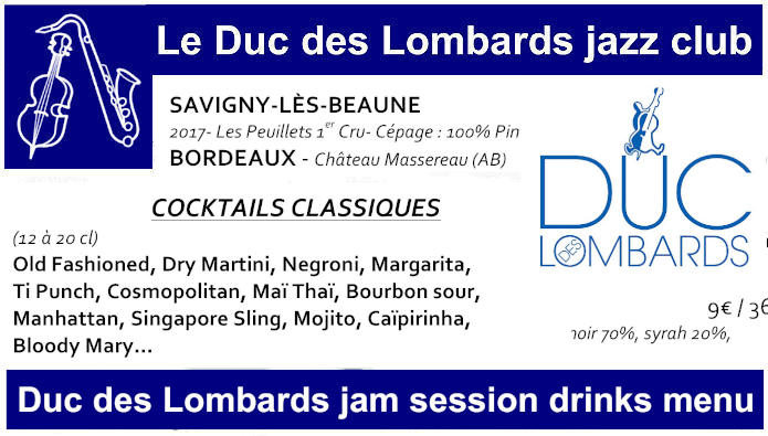
Duc des Lombards jam session menu of beverages, drinks, beers, wines, and cocktails served
Jam sessions where local performers including up and coming artists can join in the music entertainment on a Friday and Saturday night are free to those of you who manage to get a place in this cosy Jazz Club, with doors opening at 11:30pm and not closing until 4am, and here you can see the bar menu for these Duc des Lombards Jam sessions.
Paris Duc des Lombards jam session drinks menus available:
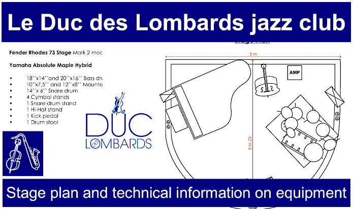
Duc des Lombards stage plan and technical information on equipment
For those of you interested in the technical equipment available to musicians that perform at Le Duc des Lombards, or if you are thinking about booking the venue or wish to get involved with one of the late night Jam sessions, then here you can discover the Duc de Lombards stage plan, its equipment such as the type of piano, double bass and drums, plus the technical specs for the sound system and other items available like guitar amps, microphones and so on.