How to get to Zenith Paris la Villette using public transport
Zenith is a popular events venue in Paris that offers over 150 concerts, shows and various other productions each year with many world famous names within the music industry playing here, so below you can see how to get to Zenith with street plans, maps and timetables for public transport including Metro, buses and night buses, which can all be downloaded to your PC or mobile device.
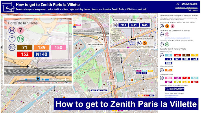
Zenith Paris la Villette transport map of Metro lines, trains, tramways, bus lines with stops, connections and street plan
Here we have a street map of the area around Parc de la Villette, which is where the Zenith concert hall is located, and as you can see, it shows the various different transport options including Metro stations, bus stops for both the day and night buses along with paths within the park for a more direct walk to Zenith entertainment venue.
How to get to Zenith Paris la Villette public transport maps available:
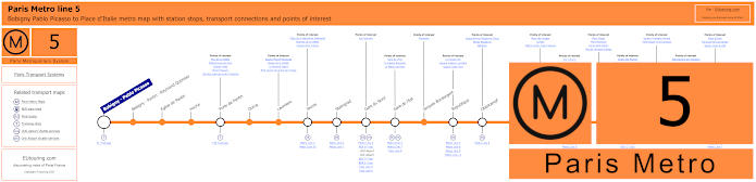
Paris Metro Line 5 map with stations, connections and points of interest
Here you can see the maps for Metro line 5 that travels between Bobigny - Pablo Picasso and Place d'Italie, and as you can see, there is a Metro stop called Porte de Pantin, which is a direct route through Parc de la Villette via the Allee du Zenith to the Zenith entertainment venue at around 650 metres.
Metro Line 5 stops:
Bobigny - Pablo Picasso, Bobigny - Pantin - Raymond Queneau, Eglise de Pantin, Hoche, Porte de Pantin, Ourcq, Laumiere, Jaures, Stalingrad, Gare du Nord, Gare de l'Est, Jacques Bonsergent, Republique, Oberkampf, Richard-Lenoir, Breguet - Sabin, Bastille, Quai de la Rapee, Gare d'Austerlitz, Saint-Marcel, Campo-Formio, Place d'Italie.
Metro line 5 main transport connections:
Metro Lines: 1, 2, 3, 4, 6, 7, 7b, 8, 9, 10, 11. Train Lines: B, C, D, E, H, K, P. Tram Lines: T1, T3b.
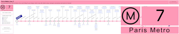
Paris Metro Line 7 map with stations, connections and points of interest
Whereas this shows the Paris Metro line 7 travelling from La Courneuve - 8 Mai 1945 through to Maison Blanche where it then branches off to either the terminus of Mairie d'Ivry or Villejuif - Louis Aragon, and for getting to Zenith you would need the Porte de la Villette stop, which is an approximate distance of between 800 and 1100 metres away depending upon what way you walk, either directly through Parc de la Villette or on the outskirts.
Metro line 7 stops:
La Courneuve - 8 Mai 1945, Fort d'Aubervilliers, Aubervilliers - Pantin - Quatre Chemins, Porte de la Villette, Corentin Cariou, Crimee, Riquet, Stalingrad, Louis Blanc, Chateau-Landon, Gare de l'Est, Poissonniere, Cadet, Le Peletier, Chaussee d'Antin - La Fayette, Opera, Pyramides, Palais Royal - Musee du Louvre, Pont Neuf, Chatelet, Pont Marie, Sully - Morland, Jussieu, Place Monge, Censier - Daubenton, Les Gobelins, Place d'Italie, Tolbiac, Maison Blanche, Porte d'Italie, Porte de Choisy, Porte d'Ivry, Pierre et Marie Curie, Mairie d'Ivry, Le Kremlin-Bicetre, Villejuif - Leo Lagrange, Villejuif - Paul Vaillant-Couturier, Villejuif - Louis Aragon.
Metro line 7 main transport connections:
Metro Lines: 1, 2, 3, 4, 5, 6, 7bis, 8, 9, 10, 11, 14. Train Lines: A, B, D, E, P. Tram Lines: T1, T3a, T3b, T7. Bus Line: RoissyBus.
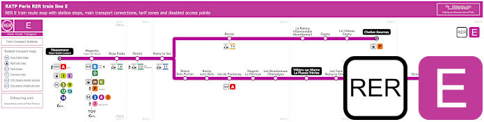
Pink RER E train line map showing station stops, line branches, transport connections and zones
Now this shows the RER E train line that goes from Haussman St-Lazare that links to Gare Saint-Lazare train station, with the next stop being Gare du Nord where the Eurostar train comes in, then you would need either the Rosa Parks station or the Pantin station at approximately 1200 metres walk. Yet from Paris to Zenith, alighting the train at Rosa Parks is still ticket tariff zone 1 rather than zone 2, but it is a longer walk of around 1800 metres away from this famous Paris music venue and below you can see live arrival and departure times at Pantin train station.
Paris RER E train line stops:
Haussmann St-Lazare*, Gare du Nord - Magenta, Rosa Parks, Pantin, Noisy le Sec, Bondy, Le Raincy - Villemomble - Montfermeil, Gagny, Le Chenay - Gagny, Chelles - Gournay*, Rosny - Bois Perrier, Rosny-sous-Bois, Val de Fontenay, Nogent - Le Perreux, Les Boullereaux - Champigny, Villiers sur Marne - Le Plessis Trevise, Les Yvris - Noisy le Grand, Emerainville - Pontault Combault, Roissy en Brie, Ozoir la Ferriere, Gretz - Armainvilliers, Tournan*.
* Terminus Points.
Paris RER E train line main transport connections:
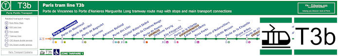
Paris tram line T3b map with tramway stations, transport connections and zones
However, the Paris Tramway Tram line T3b is also another option of how to get to Zenith, as this has a route from Porte de Vincennes to Porte d'Asnieres - Marguerite Long, and as you can see from the maps and timetables, you can choose the Porte de Pantin - Parc de la Villette stop at approximately 700 metres away, yet a longer walk of around 1100 metres and you have the Porte de la Villette - Cite des Sciences et de l'Industrie tram stop.
Paris tram line T3b stops:
Porte de Vincennes, Porte de Montreuil, Marie de Miribel, Porte de Bagnolet, Severine, Adrienne Bolland, Porte des Lilas, Hopital Robert Debre, Butte du Chapeau Rouge, Porte de Pantin (Parc de la Villette), Delphine Seyrig, Ella Fitzgerald (Grands Moulins de Pantin), Porte de la Villette (Cite des Sciences et de l'Industrie), Canal Saint-Denis, Rosa Parks, Porte d’Aubervilliers, Colette Besson, Porte de la Chapelle, Diane Arbus (Porte des Poissonniers), Porte de Clignancourt (Puces de Saint-Ouen), Angelique Compoint (Porte de Montmartre), Porte de Saint-Ouen, Epinettes - Pouchet, Honore de Balzac, Porte de Clichy (Tribunal de Paris), Port d'Asnieres - Marguerite Long.
Paris tram line T3b main transport connections:
Metro Lines: 1, 3, 3bis, 4, 5, 7, 7bis, 9, 11, 12, 13. Train Lines: C, E. Tram Line: T3a.
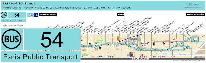
RATP Paris bus line 54 with stops, connections and street plan
Here we have the maps and timetables for the RATP Paris bus line 54 that travels from Porte d'Aubervilliers through to Pigalle and far further on to Gabriel Peri - Metro, and as you can see, this is one way of how to get to Sacre Coeur Basilica, but also an option for Zenith entertainment venue by utilising the bus stop Flandre at a distance of around 1700 metres, or the Crimee stop a little further depending upon your direction of travel.
Paris bus line 54 stops:
Gabriel Peri - Metro, Place Voltaire, Leon Blum, Danielle Casanova**, Landy - Martre*, Mairie de Clichy, Barbusse - Martre*, Jaures - Barbusse**, Victor Hugo - 8 Mai 1945*, Victor Hugo - Jean Jaures**, Porte de Clichy, Boulay, Brochant - Cardinet, Rue des Moines*, Legendre, La Fourche, Ganneron, Place de Clichy**, Place de Clichy - Caulaincourt*, Blanche, Pigalle, Rochechouart - Martyrs, Anvers - Sacre Coeur, Rochechouart - Clignancourt, Barbes - Rochechouart, Magenta - Maubeuge - Gare du Nord, La Fayette - Magenta - Gare du Nord**, Gare du Nord - Dunkerque*, Valenciennes*, Gare de l'Est, Verdun, Chateau Landon, Louis Blanc, Chaudron - Saint-Martin*, Quai de Seine - Stalingrad, Maroc - Flandre, Riquet, Crimee, Crimee - Archereau*, Crimee - Curial, Crimee - Rosa Parks, Flandre**, Cambrai**, Porte d’Aubervilliers - Macdonald, Porte d'Aubervilliers.
* Served in direction of Gabriel Peri - Metro. ** Served in direction of Porte d'Aubervilliers.
Paris bus line 54 main transport connections:
Metro Lines: 2, 4, 5, 7, 7bis, 12, 13, 14. Train Lines: B, C, D, E, H, K, P. Tram Line: T3b.
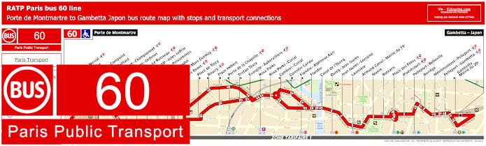
RATP Paris bus line 60 with stops, connections and route plan
This is the Paris bus line 60 run by RATP that travels between Porte de Montmartre and Gambetta - Japon and as you can see from the maps and timetables there is a bus stop called Canal de l'Ourcq, which is within walking distance of the Zenith by going along the canal and through Parc de la Villette.
Paris bus line 60 stops:
Porte de Montmartre, Gerard de nerval*, Rene Binet, Angelique Compoint, Poteau - Belliard, Damremont - Championnet, Damremont - Ordener, Duhesme - Le Ruisseau, Mairie du 18e - Jules Joffrin, Marcadet - Poissonniers, Pont Marcadet, Ordener - Marx Dormoy, Les Roses*, Place de Torcy*, Boucry*, Place Hebert*, Porte de la Chapelle*, Tristan Tzara*, Evangile - Aubervilliers, Rosa Parks, Rosa Parks - Curial, Cambrai - Curial*, Corentin Cariou*, Flandre - Alphonse Karr*, Flandre, Canal de l'Ourcq, Ourcq - Jean Jaures, Jean Jaures - Lorraine, Laumiere, Armand Carrel - Mairie du 19e, Manin, Botzaris, Place des Fetes, Pixerecourt, Pelleport - Belleville, Borrego, Menilmontant - Pelleport, Pelleport - Gambetta, Gambetta - Mairie du 20e, Gambetta - Japon.
* Please check maps as these stops are direction dependant.
Paris bus line 60 main transport connections:
Metro Lines: 3, 3bis, 4, 5, 7, 7bis, 11, 12. Train Lines: E. Tram Lines: T3a, T3b.
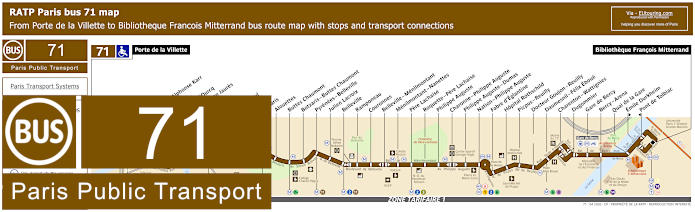
RATP Paris bus 71 map with stops, connections and street plan
Yet the RATP bus line 71 is also an option of public transport for Zenith as it goes from the Porte de la Villette by the Metro and tram stations, and this is also how to get to Bercy Arena, the Bibliotheque Francois Mitterrand and other tourist attractions like Pere Lachaise cemetery.
Paris bus line 71 stops:
Porte de la Villette, Cambrai**, Flandre - Alphonse Karr, Flandre, Canal de l'Ourcq, Ourcq - Jean Jaures, Ourcq, Goubet, D'Hautpoul, Manin, Botzaris, Alouettes, Buttes Chaumont, Pyrenees - Belleville, Julien Lacroix, Belleville, Ramponeau, Couronnes, Belleville - Menilmontant, Menilmontant - Nanettes, Pere Lachaise, Roquette - Pere Lachaise, Philippe Auguste, Charonne - Philippe Auguste, Philippe Auguste - Dumas, Nation - Philippe Auguste, Fabre d'Eglantine, Hopital Rothschild, Picpus - Reuilly, Docteur Goujon - Reuilly, Daumesnil - Felix Eboue, Charenton - Wattignies, Dugommier, Gare de Bercy, Bercy - Arena, Quai de la Gare, Emile Durkheim**, Pont de Tolbiac*, Bibliotheque Francois Mitterrand.
* Stop served in direction of Porte de la Villette. ** Stop served in direction of Bibliotheque Francois Mitterrand.
Paris bus line 71 main transport connections:
Metro Lines: 1, 2, 3, 5, 6, 7, 7bis, 8, 11, 14. Train Lines: A, C. Tram Lines: T3a, T3b.
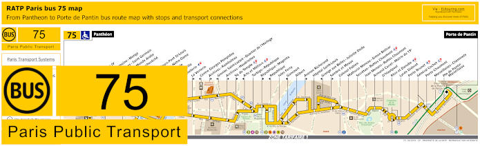
RATP Paris bus line 75 with stops, connections and street plan
Porte de Pantin is actually the closest stop for Paris transport to Zenith, and here you can see the maps and timetables for bus line 75, which starts at Porte de Pantin and travels through to the Pantheon, but there are also many other tourist attractions on this bus route, although please note that some bus stops like Cite - Parvis Notre-Dame are only served in one direction.
Paris bus line 75 stops:
Pantheon, Lycee Henri IV**, Cardinal Lemoine - Monge**, Saint-Jacques - Saint Germain*, Institut du Monde Arabe*, Pont de l’Archeveche**, Petit Pont*, Quai aux Fleurs - Pont St-Louis**, Cite - Parvis Notre-Dame*, Pont d’Arcole**, Hotel de Ville**, Coutellerie*, La Verrerie**, Centre Georges Pompidou*, Archives - Rambuteau**, Grenier Saint-Lazare - Quartier de l’Horloge*, Archives - Haudriettes*, Square du Temple**, Arts et Metiers*, Turbigo - Republique, Republique - Magenta**, Republique*, Jules Ferry, Goncourt*, Alibert, Avenue Richerand**, Hopital Saint-Louis, Grange aux Belles - Juliette Dodu*, Sambre et Meuse**, Colonel Fabien, Mathurin Moreau - Simon Bolivar, Secretan - Buttes Chaumont, Jean Menans - Buttes Chaumont, Armand Carrel - Mairie du 19e, D’Hautpoul, Rhin et Danube, Lycee Diderot, Porte Brunet, General Cochet, Porte Chaumont, Marseillaises - Cheminets, Porte de Pantin - Marseillaise, Porte de Pantin.
* Stop served in direction of Pantheon. ** Stop served in direction of Porte de Pantin.
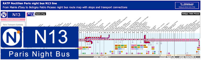
Paris Noctilien night bus N13 map with stops and transport connections
You will find that the Paris Noctilien buses run when other public transport has finished for the night, normally between the hours of approximately 12:30am and 5:30am, and here you can see the maps and timetables for the night bus line N13 that travels from central Paris to Mairie d'Issy in one direction and Bobigny - Pablo Picasso in the other, with numerous connections on route, and for Zenith you would need the Porte de Pantin bus stop.
Paris night bus line N13 stops:
Mairie d'Issy, Victor Hugo, Freres Voisin*, Colonel Pierre Avia*, Maison de Retraite**, Severine**, Louis Armand*, Porte d'Issy**, Suzanne Lenglen*, Balard*, Firmin Gillot**, Balard - Lecourbe*, Lycee Louis Armand*, Duranton*, Vaugirard - Croix Nivert**, Hopital de Vaugirard**, Convention - Lecourbe*, Convention - Vaugirard**, Abbe Groult, Mairie du 15e*, Vaugirard - Favorites**, Cambronne - Lecourbe*, Cambronne - Vaugirard**, Volontaires - Lecourbe*, Volontaires - Vaugirard**, Sevres - Lecourbe*, Pasteur - Falguiere**, Pasteur - Lycee Buffon*, Armorique - Musee Postal, Gare Montparnasse, Montparnasse - Rue de l'Arrivee*, Montparnasse**, Rennes - Littre, Rennes - Saint-Placide, Rennes - d'Assas, Michel Debre, Saint-Germain-des-Pres*, Jacob*, Bonaparte - Saint-Germain**, Pont du Carrousel - Quai Voltaire*, Pont des Arts - Quai Conti*, Pont Neuf - Quai des Grands Augustins*, Seine - Buci**, Saint-Michel*, Saint-Germain - Odeon**, Saint-Michel - Saint-Germain**, Cite - Palais de Justice, Chatelet, Les Halles - Centre Georges Pompidou**, Centre Georges Pompidou*, Turbigo - Etienne Marcel**, Grenier St-Lazare - Quartier de l'Horloge*, Reaumur - Sebastopol**, Reaumur - Arts et Metiers*, Strasbourg - Saint-Denis**, Porte Saint-Martin*, Chateau d'Eau**, Mairie du 10e*, Gare de l'Est, Verdun**, Chateau Landon, Louis Blanc, Jaures, Jean Jaures - Lorraine, Ourcq, Porte de Pantin - Metro, Hoche - Metro, Montgolfier, Centre National de la Danse, Pantin RER - Mairie, Delizy, Diderot, Cimetiere Parisien, Chemin des Vignes, Henri Gautier, Lycee Alfred Costes, Gare - Grande Ceinture, Escradille Normandie-Niemen - Jean Jaures - Tramway, Escadrille Normandie-Niemen - Paul Vaillant-Couturier - Tram, Lieutenant Lebrun, Pierre Semard, Bobigny - Pablo Picasso.
* Only served in the direction of Mairie d'Issy. ** Only served in the direction of Bobigny - Pablo Picasso.
Paris night bus line N13 main transport connections:
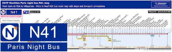
Paris Noctilien night bus N41 map with stops and transport connections
Whereas this shows the Noctilien bus line N41 night bus travelling from Villeparisis - Mitre-le-Neuf RER to the transport hub of Gare de l'Est train station, and when you are looking at how to get from Zenith to Paris, then you will find the nearest bus stop is the Porte de Pantin, having walked through Parc de la Villette along the Allee du Zenith.
Paris night bus line N41 stops:
Gare de l'Est, Verdun**, Chateau Landon, Louis Blanc, Jaures, Jean Jaures - Lorraine, Ourcq, Porte de Pantin, Hoche, Montgolfier, Centre National de la Danse, Pantin RER - Mairie, Delizy, Diderot, Cimetiere Parisien, Chemin des Vignes, Henri Gautier, Lycee Alfred Costes, Gare - Grande Ceinture, Escadrille Normandie-Niemen - Jean Jaures, Escadrille Normandie-Niemen - Paul Vaillant-Couturier, Lieutenant Lebrun, Pierre Semard, Bobigny - Pablo Picasso**, Rene Camier*, Lamartine, Cite Administrative**, Auguste Delaune*, Rue des Peupliers, Pont de Bondy, Avenue de Rosny, Gatine**, Auguste Pollissard, Pasteur - Hopital Jean Verdier, Hopital Jean Verdier, Villageoise, Lycee Claude-Nicolas Ledoux, Louise Michel, Robert Schuman, Cimetiere*, Zone Industrielle de la Poudrette, Colonel Fabien, Victor Hugo - Jules Guesde, Victor Hugo - Jean Moulin**, Chanzy, Gambetta, Charles de Gaulle, Mairie de Livry-Gargan, Place de la Liberation, Jean-Jacques Rousseau, Maurouard, Louis Menard, Sevran - Livry*, Sevran - Livry RER, Square H. Legrand, Brazza, Vert Galant RER, Jean Guimier, Lavoisier, Villeparisis - Mitry-le-Neuf RER.
* Served in direction of Gare de l'Est. ** Served in direction of Villeparisis - Mitry-le-Neuf RER.
Paris night bus line N41 main transport connections:
Metro Lines: 2, 4, 5, 7, 7bis. Train Lines: B, E, P. Tram Lines: T1, T3b. Bus Lines: N01, N02, N13, N14, N41, N42, N43, N44, N45, N140, N141, N142, N143.
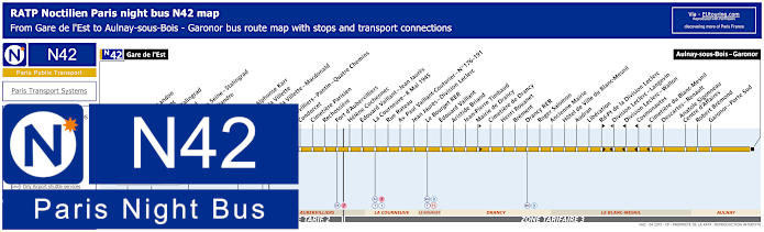
Paris Noctilien night bus N42 map with stops and transport connections
The Noctilien night bus line 42 also goes from Gare de l'Est but to Aulnay-sous-Bois - Garoner and for the Zenith you would need the night bus stops Flandre - Alphonse Karr or the main transport point of Porte de la Villette for Paris or Porte de la Villette - Macdonald to go in the opposite direction, as you can see from the Noctilien maps.
Paris night bus line N42 stops:
Gare de l'Est, Verdun, Chateau-Landon, Louis Blanc, Jaures - Stalingrad, Stalingrad, Quai de la Seine - Stalingrad, Maroc - Flandre, Riquet, Crimee, Flandre - Alphonse Karr, Porte de la Villette, Porte de la Villette - Macdonald, Magenta, Aubervilliers - Pantin - Quatre Chemins, Condorcet, Cimetiere Parisien, Rechossiere, Fort d’Aubervilliers, Helene Cochennec, Edouard Vaillant - Jean Jaures, La Courneuve - 8 Mai 1945, Rue Rateau, Avenue Paul Vaillant-Couturier - No 176–191, Jean Jaures - Division Leclerc, Le Bourget RER, Edouard Vaillant, Aristide Briand, Jean-Pierre Timbaud, Mairie de Drancy, Cimetiere de Drancy, Henri Rouanet, Brement, Drancy RER, Roger Salomon, Ancienne Mairie, Hotel de Ville du Blanc-Mesnil, Audran, Liberation, Rond-Point de la Division Leclerc, Division Leclerc - Langevin, Division Leclerc - Wallon, Cosmonautes, Cimetiere du Blanc-Mesnil, Descartes - Renault, Anatole Sigonneau - Centre d'Affaires, Robert Bremond, Garonor - Porte Sud, Aulnay-sous-Bois - Garonor.
Paris night bus line N42 main transport connections:
Metro Lines: 2, 4, 5, 7, 7bis. Train Line: B. Tram Lines: T1, T3b, T11. Bus Lines: N01, N02, N13, N14, N41, N43, N44, N45, N140, N141, N142, N143.
Paris Noctilien night bus N45 map with stops and transport connections
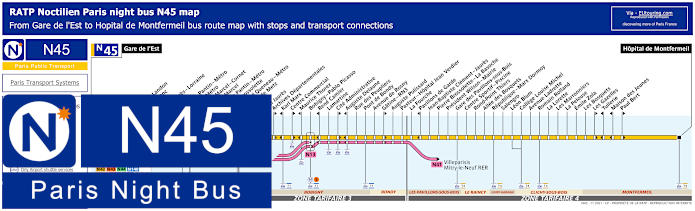
Yet the night bus line N45 goes to Hopital de Montfermeil from Gare de l'Est train station and just like Noctilien N41, the N45 route has a bus stop at Porte de Pantin for Zenith if you are late after a performance, but as you can tell from the maps and timetables the route goes through different communes, or areas of the Paris region, including Bobigny, Bondy, Le Raincy and Clichy-sous-Bois to ticket tariff zone 4 from Paris zone 1.
Paris night bus line N45 stops:
Gare de l'Est, Verdun**, Chateau Landon, Louis Blanc, Jaures, Jean Jaures - Lorraine, Ourcq, Porte de Pantin - Metro, Hoche - Metro**, Etienne Marcel - Cornet*, Etienne Marcel**, Eglise de Pantin - Metro, Pierre Brossolette, Raymond Queneau - Metro, Avenue de Metz, La Folie, Jean Jaures, Archives Departmentales**, Karl Marx*, Centre Commercial**, Maurice Thorez*, Bobigny - Pablo Picasso, Rene Camier*, Lamartine, Cite Administrative**, Auguste Delaune*, Rue des Peupliers, Pont de Bondy, Avenue de Rosny, Gatine - RN3**, Auguste Polissard, Pasteur - Hopital Jean Verdier, La Fourche, Pavillons de Garde*, Jean-Baptiste Clement - Jaures, Pierre Brossolette - La Basoche, President Wilson - Mairie, Gare des Pavillons-sous-Bois, Centre Sportif - Piscine, Rond-Point Thiers, Allee des Bosquets, Republique - Marx Dormoy, Salengro, Leon Blum, College Louise Michel, Avenue Ladrette, Romain Rolland, La Lorette, Les Marronniers, La Pelouse, Emile Zola, Les Bosquets, Les Gazelles**, Tuilerie*, Maison des Jeunes*, Paul Bert**, Hopital de Montfermeil.
*Stop served in direction of Gare de l'Est. ** Stop served in direction of Hopital de Montfermeil.
Paris night bus line N45 main transport connections:
Paris Noctilien night bus N140 map with stops and transport connections
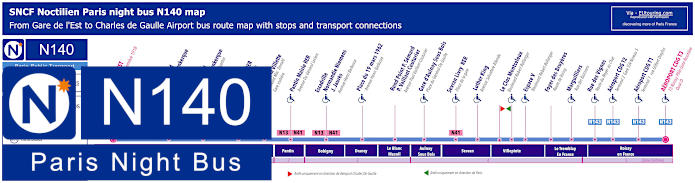
However, if you are thinking of how to get to Charles de Gaulle Airport from Zenith late at night, then you are in luck with the Noctilien night bus line N140 that has a bus stop at Porte de la Villette at the bus station on Boulevard MacDonald, yet please look at the maps and timetables, as there is one particular time schedule shown in red that only operates on a Saturday, Sunday and French holidays, rather than the other times throughout the year.
Paris night bus line N140 stops:
Gare de l’Est - Place du 11 Novembre 1918, Gare du Nord - Lafayette Dunkerque - 170 Rue Lafayette*, Gare du Nord - 33 Rue de Saint Quentin**, Rosa Parks RER - Rue Gaston Tessier, Porte de la Villette - Boulevard MacDonald - Gare Routiere, Pantin Mairie RER - Avenue du General Leclerc, Escadrille Normandie Niemens - J. Jaures - Avenue Henri Barbusse, Place du 19 Mars 1962 - Avenue Henri Barbusse, Rond Point P.Semard - Paul Vaillant Couturier - Avenue Paul Vaillant-Couturier***, Gare d’Aulnay-sous-Bois - Place du General de Gaulle, Sevran Livry RER - Place de la Gare, Luther King - Avenue Salvadore Allende, Le Clos Montceleux - Boulevard Robert Ballanger* ***, Espace V - Boulevard Robert Ballanger, Foyer des Bruyeres - Route de Roissy, Marguilliers - Rue des Buissons, Rue des Vignes - Route du Noyer au Chat, Aeroport CDG T2 - Terminal 2 Gare TGV Niveau 5, Aeroport CDG T1 - Terminal 1 Rue Gilbert Dreyfus, Aeroport CDG T3 - T3 Roissy Pole Gare Routiere Quai D.
* Night bus stop served in direction of Charles de Gaulle Airport. ** Night bus stop served in direction of Paris Gare de l'Est. *** Not disabled friendly in direction of CDG Airport.
Paris night bus line N140 main transport connections:
Metro Lines: 4, 5, 7. Train Lines: B, E, P, TGV. Bus Lines: N01, N02, N13, N14, N41, N42, N43, N44, N45, N141, N142, N143, Plus CDG Airport Transport Connections.
RATP Paris bus line 139 with stops, connections and street plan
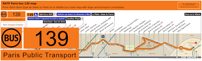
The RATP bus 139 for Zenith travels has a starting point of Porte de la Villette and this is one way of how to get to Stade de France, another entertainment and sports venue, via the main stop of La Plaine - Stade de France, yet as you can see from the maps and timetables, this travels further on depending upon the day, although due to works temporarily, this bus route does not go all the way to Saint-Ouen - Quai de Seine. which is why certain bus stops are crossed out at present.
Paris bus line 139 stops:
Quai de Seine**, Saint-Ouen - Quai de Seine, Rue Nicolau, Rue Ampere, Carrefour Pleyel, Docteur Finot, Landy - Pleyel, Landy - Cheminots, Stade de France - St-Denis, Avenue des Fruitiers, Wilson - De Pressense, La Plaine - Stade de France, Murger, Saint-Gobain, La Montjoie - Germaine Tillion, Metallurgie, Front Populaire - Proudhon, Front Populaire - Gardinoux, 18, rue du Pilier*, Aubervilliers - France-Asie*, Rue de la Haie Coq**, Gardinoux**, Quai Lucien Lefranc*, Aime Cesaire, Felix Faure - Rue des Ecoles, Karman - Felix Faure, Place Auguste Baron, Porte de la Villette.
* Stop served in direction of Saint-Ouen - Quai de Seine. ** Stop served in direction of Porte de la Villette.
RATP Paris bus line 150 with stops, connections and route plan
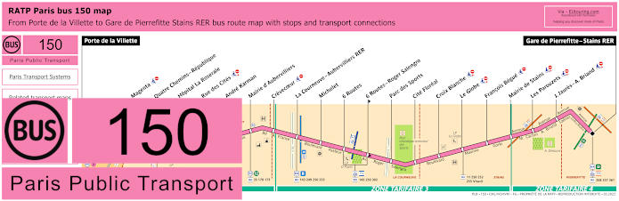
Whereas the bus line 150 goes from Gare de Pierrefitte - Stains RER to Porte de la Villette in Paris, which is one of the main stops for Zenith, and as you can tell from the bus maps and timetables, this travels through various communes, or areas, including Aubervilliers in ticket tariff zone 2 and La Courneuve in ticket zone 3.
Paris bus line 150 stops:
Porte de la Villette, Magenta, Quatre Chemins - Republique, Hopital La Roseraie, Rue des Cites, Andre Karman, Mairie d'Aubervilliers, Crevecoeur, La Courneuve - Aubervilliers RER , Michelet, 6 Routes, 6 Routes - Roger Salengro**, Parc des Sports, Cite Floreal, Croix Blanche, Le Globe, Francois Begue, Mairie de Stains, Les Parouzets, J. Jaures - A. Briand, Gare de Pierrefitte - Stains RER.
** Served in direction of Gare de Pierrefitte - Stains RER.
Paris bus line 150 main transport connections:
Metro Line: 7. Train Lines: B, D. Tram Lines: T1, T3b, T11. Bus Lines: 11, 139, 143, 152, 170, 249, 250, 252, 253, 255, 268, 302, 337, 361, Vitavil.
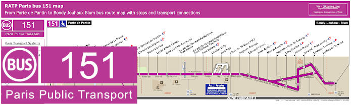
RATP Paris bus line 151 with stops, connections and street plan
Although as you can see from the Paris bus line 151 maps and timetables, this bus route goes from the nearest stop to Zenith at the Porte de Pantin through to Bondy - Jouhaux - Blum with bus stops between in different communes of Pantin, Bobigny, Drancy and Bondy that have various transport connections.
Paris bus line 151 stops:
Porte de Pantin, Petits Ponts, Hoche - Metro, Montgolfier, Centre National de la Danse, Pantin RER - Mairie, Delizy, Diderot, Cimetiere Parisien de Pantin, Chemin des Vignes, Henri Gautier, Lycee Alfred Costes, Gare (Grande Ceinture), Escradille Normandie-Niemen - Jean Jaures, Escradille Normandie-Niemen - Paul Vaillant-Couturier, Paul Belwo, Charles Gide, Jane Joyce, Place du 19 Mars 1962, Auguste Blanqui, Edouard Lievin, Jules Auffret, Marcel Cachin, Argonne - Bois de Groslay**, Cooperation*, Albert David*, Surcouf - Jean Jaures*, Surcouf - Lejeune**, Jardins de la Noue, Bondy - Jouhaux - Blum.
* Served in direction of Porte de Pantin. ** Served in direction of Bondy - Jouhaux - Blum.
Paris bus line 151 main transport connections:
Metro Line: 5. Train Line: E. Tram Lines: T1, T3b. Bus Lines: 75, 134, 143, 146, 148, 170, 248, 249, 251, 330, 334, 346, 351, 615, 616, 620, TUB (546).
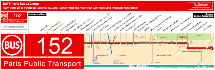
RATP Paris bus line 152 with stops, connections and street plan
Yet the bus line 152 goes from Gonesse - ZAC des Tulipes Nord to Porte de la Villette, which as we have mentioned before, is one of the main public transport options for Zenith at the Parc de la Villette, but this is also one of the bus routes for how to get to Musee de l'Air et de l'Espace at Bourget airport where the Paris air show is held.
Paris bus line 152 stops:
Porte de la Villette, Magenta, Quatre Chemins, Condorcet, Cimetiere Parisien, Rechossiere, Fort d'Aubervilliers, Helene Cochennec, Edouard Vaillant - Jean Jaures, La Courneuve - 8 Mai 1945, Rue Rateau, Av. P. Vaillant-Couturier No 176-191, Jean Jaures - Division Leclerc, Anizan Cavillon - Hotel de Ville, Pierre Curie, Eglise du Bourget, Michelet - Parc des Expositions, Diderot, Musee de l'Air et de l'Espace, Lenine, Chemin Notre-Dame, Pont-Yblon - Santos Dumont, Colonel Fabien, Ferme Saint-Simon, Route des Parcs, 21eme Siecle, Gonesse - ZAC des Tulipes Nord.
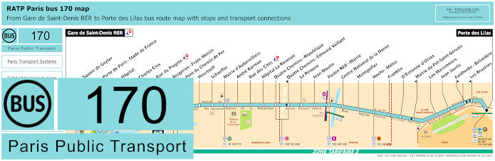
RATP Paris bus line 170 with stops, connections and route plan
But the RATP bus line 170 goes from Gare de Saint-Denis RER to Porte des Lilas on the outskirts of Paris, yet as you will see from the 170 maps and timetables, there is the Pantin RER - Mairie stop and the Hoche - Metro stop that are both between a walking distance of approximately 1100 to 1300 metres from the Zenith entertainment venue depending upon which way you walk.
Paris bus line 170 stops:
Gare de Saint-Denis RER, Square de Geyter, Porte de Paris - Stade de France, Hopital, Charles Cros, Rue du Progres, Bergeries - Franc Moisin, Pont du Chemin de Fer, Heurtault, Schaeffer, Mairie d'Aubervilliers, Andre Karman, Rue des Cites, Hopital La Roseraie, Quatre Chemins - Republique, Quatre Chemins - Edouard Vaillant*, La Perouse, Jean Moulin, Pantin RER - Mairie, Centre National de la Danse, Montgolfier, Hoche - Metro, Franklin, D'Estienne d'Orves, Mairie du Pre-Saint-Gervais, Les Marronniers, Jean Jaures, Faidherbe - Belvedere**, Les Bruyeres*, Porte des Lilas.
* Stop served in direction of Gare de Saint-Denis RER. ** Stop served in direction of Porte des Lilas.
Paris bus line 170 main transport connections:
Metro Lines: 3bis, 5, 7, 11, 13. Train Lines: D, E, H. Tram Lines: T1, T3b, T8. Bus Lines: 35, 48, 61, 96, 105, 115, 129, 150, 151, 152, 153, 173, 239, 249, 253, 254, 255, 274, 330, 356, 512.
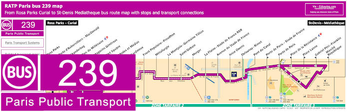
RATP Paris bus line 239 with stops, connections and street plan
The Paris bus line 239 travels from St-Denis - Mediatheque through to Rosa Parks - Curial, which is close to the Rosa Parks train station and around 1500 metres from Zenith, and as you can see from the maps and timetables, this operates daily, but at different times on a Monday to Friday depending upon whether it is the academic year or school holidays.
Paris bus line 239 stops:
Rosa Parks - Curial, Rosa Parks, Porte d'Aubervilliers - MacDonald, Skanderbeg**, Parc du Millenaire*, Magasins Generaux, Net Square, Modes et Medias, Gardinoux**, Front Populaire - Proudhon, Metallurgie, La Montjole - Germaine Tillion, Saint-Gobain, Murgot, La Plaine - Stade de France RER, Avenue du Stade de France, Jesse Owens, Delaunay - Rimet, Pont du Canal, Porte de Paris - Stade de France**, Porte de Paris, Place de la Resistance*, Place Lanne**, Gabriel Peri - Franklin*, Marche - Republique*, St-Denis - Mediatheque.
* Stop served in direction of Rosa Parks - Curial. ** Stop served in direction of St-Denis - Mediatheque.
Paris bus line 239 main transport connections:
Metro Lines: 12, 13. Train Lines: B, E. Tram Lines: T3b, T8. Bus Lines: 35, 45, 54, 60, 139, 153, 170, 173, 253, 255, 302, 353, 356, 512, La Traverse (518).
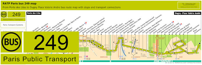
RATP Paris bus line 249 with stops, connections and street plan
However, here you can see the maps and timetables for the RATP Bus line 249 that travels between Porte des Lilas and Dugny - Place Valerie Andre and the nearest bus stop to Zenith within the Parc de la Villette for this bus line is called Pantin RER - Mairie at about 1300 metres walk away.
Paris bus line 249 stops:
Porte des Lilas, Les Bruyeres**, Faidherbe - Belvedere*, Convention, Les Pommiers, Montigny - Maison de Retraite, Paul Bert - Cimetiere, 8 Mai 1945, Lycee Prof. Simone Weil - Eglise de Pantin, Louis Nadot***, Cheval Blanc* ***, Delizy, Pantin RER - Mairie, Jean Moulin, La Perouse, Quatre Chemins - Edouard Vaillant**, Quatre Chemins - Republique, Hopital - La Roseraie, Paul Bert, Les Roses**, Nouvelle France*, Maison de Retraite, Cimetiere - Pont Blanc, Danielle Casanova - Pont Blanc, Petit Chemin du Pont Blanc, La Courneuve - Aubervilliers RER, General Schramm, Mecano, Hotel de Ville - Centre Administratif, Hotel de Ville de La Courneuvre - Tramway*, Chabrol, Jean Mermoz - Henri Barbusse, Cite Waldeck-Rochet, Cimetiere, Centre des Essences, Dugny - La Courneuve, Albert Chardavoine, Place du 16 Aout 1943*, Adolphe Devaux**, Gabriel Peri*, Centre-Ville de Dugny*, Cite du Moulin*, Leo Lagrange*, Georges Guynemer, Place Casanova, Dugny - Place Valerie Andre.
* Stop served in direction of Porte des Lilas. ** Stop served in direction of Dugny - Place Valerie Andre. *** Cheval Blanc stop only served on the first three departures each day travelling in the direction of Porte des Lilas replacing the Louis Nadot bus stop.
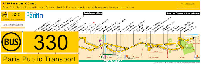
RATP Paris bus line 330 with stops, connections and street plan
But the bus line 330 travels between Raymond Queneau - Anatole France and Fort d'Aubervilliers passing through communes, or areas, including Pantin and Lilas, and for how to get to Zenith within the Parc de la Villette you would need either the bus stop Hoche or Pantin RER - Mairie, both of which are approximately 1200 to 1300 metres away.
Paris bus line 330 stops:
Cite du Pont de Pierre***, Les Courtillieres***, Division Leclerc - Stendhal***, Place du Marche***, Division Leclerc - Courtillieres***, Maison de Quartier - Courtillieres***, Fort d'Aubervilliers*, Fort d'Aubervilliers**, Rechossiere, Cimetiere Parisien, Condorcet, Jacques Cottin**, Cartier Bresson**, Quatre Chemins - La Poste*, La Perouse*, Jean Moulin, Pantin RER - Mairie, Centre National de la Danse, Montgolfier*, Congo**, Hoche - Jean Lolive**, Hoche - Metro, Etienne Marcel - Cornet**, Etienne Marcel*, Cine 104, 8 Mai 1945, Paul Bert - Cimetiere, Montigny - Maison de Retraite, Les Pommiers**, Maison de Quartier - Pommiers*, Convention**, Rue Marcelle**, Pommiers - Cimetiere, Parc Henri Barbusse**, Charles Auray, Jules Jaslin, Raymond Queneau - Anatole France.
* Served in direction of Raymond Queneau - Anatole France. ** Served in direction of Fort d'Aubervilliers. *** Stop served in one direction in a loop from Fort d'Aubervilliers and back to the stop before carrying on to Raymond Queneau - Anatole France.
Paris bus line 330 main transport connections:
Metro Lines: 5, 7. Train Line: E. Tram Line: T3b. Bus Lines: 145, 147, 151, 152, 170, 173, 234, 248, 249, 250, 318, Le P'tit Bus du Pre (573).
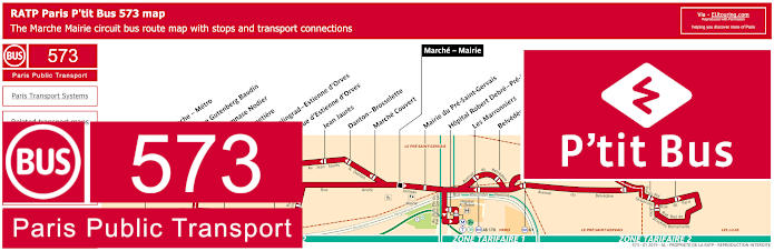
RATP Paris P'tit bus line 573 with stops, connections and street plan
Now this particular bus is called P'tit Bus, bus is also referred to RATP bus line 573 and by the name P'tit Bus Le Pre-Saint-Gervais, and as you can see from the maps and timetables, this runs in a loop from Marche - Mairie, with the nearest bus stop to Zenith being the Hoche - Metro stop.
Paris P'tit bus line 573 stops:
Marche - Mairie*, Marche Couvert, Danton - Brosselette, Jean Jaures, Cimetiere, Rue Gutenberg Baudin, Hoche - Metro, Gymnase Nodier, Stalingrad - Estienne d'Orves, Rue d'Estienne d'Orves, Mairie du Pre-Saint-Gervais, Hopital Robert Debre - Pre-St-Gervais, Les Marronniers, Belvedere - Sente des Marchais, Jean Jaures - Belvedere, Edouard Vaillant - Severine, Jacques Prevert - Edouard Vaillant, Convention, Les Bruyeres, Mairie des Lilas, Babylone.
Paris P'tit bus line 573 main transport connections:
Metro Lines: 5, 7bis, 11. Tram Line: T3b. Bus Lines: 48, 75, 105, 129, 151, 170, 330, 515 (Till Bus).
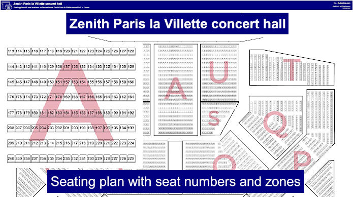
Zenith Paris la Villette concert hall seating plan with seat numbers and zones
So here we have a general seating plan for the Zenith Paris la Villette, which shows the layout with seat numbers and the different sections, and although this is the normal configuration, we would like to point out that the seating plan layout can change depending upon the requirements of the event, so please do check this when going to book your tickets for a concert or other type of performance that you wish to see.
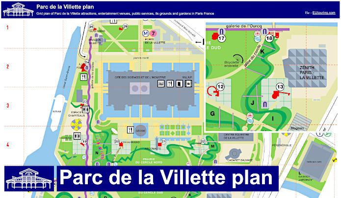
Grid plan of Parc de la Villette attractions, entertainment venues and public services
Here you can see a detailed plan of Parc de la Villette with a grid reference that shows where all the various attractions are situated like the Cite des Sciences Museum and the Argonaute Submarine, not forgetting the numerous entertainment venues like Zenith and the Grande Halle. Yet you will also see the locations of the various gardens, the folies and the canal, along with essential services such a public toilets, in addition to where you can catch public transport etc, making this an essential guide to this cultural park in Paris.