How to get to Le Dome de Paris using public transport
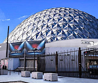
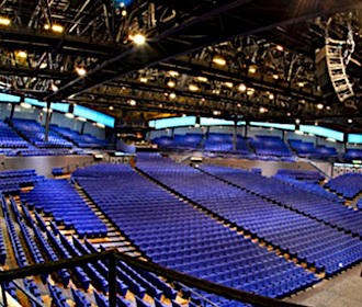
Originally called the Palais des Sports, it is now called Le Dome de Paris - Palais des Sports due to its impressive dome that has played host to numerous international stars over the decades including The Beatles, Elton John, etc, not forgetting musicals, sports events, theatre productions and more in a space that can accommodate over 4,000 people. So below, you can discover how to get to Le Dome de Paris via Paris public transport including maps, timetables, plans and information that can all be downloaded by PDF or image format to your PC or mobile device.
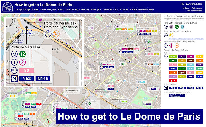
Le Dome de Paris transport map of Metro lines, trains, tramways, bus lines with stops, connections and street plan
Here you can see a map showing the location of Le Dome de Paris - Palais des Sports with GPS co-ordinates along with the various public transport options such as metro lines, trams, trains and buses including bus stops that will all get you within walking distance of this impressive event venue, which will be no more than around 1800 metres away, or a little over a mile.
How to get to Le Dome de Paris public transport maps available:
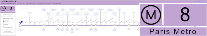
Paris Metro Line 8 map with stations, connections and points of interest
Here you can see the maps for Metro line 8, which is run by the transport company RATP, and travelling between Balard and Creteil - Pointe du Lac, as you can see, this has stops at many Paris tourist attractions including getting to Bastille, the Palais Garnier opera House via the Opera stop, historical Les Invalides, and many others, not forgetting you can utilise this Metro line as an option for how to get to the Dome de Paris via the Balard stop and terminus point.
Metro line 8 stops:
Balard, Lourmel, Boucicaut, Felix Faure, Commerce, La Motte-Picquet - Grenelle, Ecole Militaire, La Tour-Maubourg, Invalides, Concorde, Madeleine, Opera, Richelieu-Drouot, Grands Boulevards, Bonne Nouvelle, Strasbourg - Saint-Denis, Republique, Filles du Calvaire, Saint-Sebastien - Froissart, Chemin Vert, Bastille, Ledru-Rollin, Faidherbe - Chaligny, Reuilly - Diderot, Montgallet, Daumesnil, Michel Bizot, Porte Doree, Porte de Charenton, Liberte, Charenton - Ecoles, Ecole Veterinaire de Maisons-Alfort, Maisons-Alfort - Stade, Maisons-Alfort - Les Juilliottes, Creteil - L'Echat, Creteil - Universite, Creteil - Prefecture, Creteil - Pointe du Lac.
Metro line 8 main transport connections:
Metro Lines: 1, 3, 4, 5, 6, 7, 9, 10, 11, 12, 13, 14. Train Lines: A, C. Tram Lines: T2, T3a. Bus Lines: RoissyBus, TVM (14).
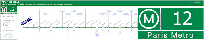
Paris Metro Line 12 map with stations, connections and points of interest
The best and nearest option for getting to Le Dome de Paris is via Metro line 12, which has a stop called Porte de Versailles, and as you can see from the maps, this is also the best Metro stop for how to get to the Parc des Expositions de Paris exhibition centre and event venue, and travelling from Mairie d'Aubervilliers through to Mairie d'Issy, it is also great for visiting the Montmarte area and other popular Paris entertainment venues.
Metro line 12 stops:
Mairie d'Aubervilliers (Plaine des Vertus), Aime Cesaire, Front Populaire, Porte de la Chapelle, Marx Dormoy, Marcadet - Poissonniers, Jules Joffrin, Lamark - Caulaincourt, Abessesses, Pigalle, Saint-Georges, Notre-Dame-de-Lorette, Trinite - d'Estienne d'Orves, Saint-Lazare, Madeleine, Concorde, Assemblee Nationale, Solferino, Rue du Bac, Sevres - Babylone, Rennes, Notre-Dame-des-Champs, Montparnasse - Bienvenue, Falguire, Pasteur, Volontaires, Vaugirard, Convention, Porte de Versailles, Corentin Celton, Mairie d'Issy.
Metro line 12 main transport connections:
Metro Lines 1, 2, 3, 4, 6, 8, 10, 13, 14. Train Lines: C, E, J, L, N, Funiculaire de Montmartre. Tram Lines: T2, T3a, T3b.
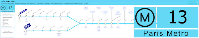
Paris Metro Line 13 map with stations, connections and points of interest
Whereas here you have the Metro line 13, with the stop needed for the Dome de Paris being Malakoff - Plateau de Vanves, although we would like to point out that this would be a walk of around 1800 metres from the entertainment venue, but travelling from Chatillon Montrouge this Metro line is an option for getting to the Stade de France via the Saint-Denis - Porte de Paris stop on the branch that goes to St-Denis Universite, whereas the other branch goes to Asnieres Gennevilliers - Les Courtilles.
Metro line 13 stops:
St-Denis Universite, Basilique de St-Denis, Saint-Denis - Porte de Paris, Carrefour Pleyel, Mairie de St-Ouen, Garibaldi, Porte de St-Ouen, Guy Moquet, Asnieres - Gennevilliers Les Courtilles, Les Agnettes, Gabriel Peri, Mairie de Clichy, Porte de Clichy, Brochant, La Fourche, Place de Clichy, Liege, Saint-Lazare, Miromesnil, Champs-Elysees - Clemenceau, Invalides, Varenne, Saint-Francois-Xavier, Duroc, Montparnasse - Bienvenue, Gaite, Pernety, Plaisance, Porte de Vanves, Malakoff - Plateau de Vanves, Malakoff - Rue Etienne Dolet, Chatillon Montrouge.
Metro line 13 main transport connections:
Metro Lines: 1, 2, 3, 4, 6, 8, 9, 10, 12, 14. Train Lines: C, E, J, L, N. Tram Lines: T1, T3a, T3b, T5, T6, T8.
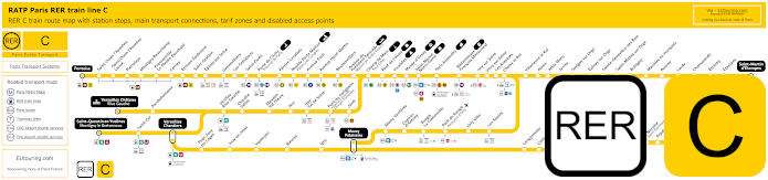
Yellow RER C train line map showing station stops, line branches, transport connections and zones
At a distance of approximately 1400 metres from Le Dome de Paris - Palais des Sports, you have the Pont du Garigliano - Hopital Europeen Georges Pompidou train station, which serves the RER C line, and as you will see from the maps, there are several branches going from central Paris, and this is one of the options for how to get to Chateau de Versailles via the terminus of Versailles Chateau Rive Gauche, yet other terminuses include St-Quentin en Yvelines, Pontoise and Dourdan la Foret.
Paris RER C train line stops:
Pontoise*, St-Ouen l'Aumone, St-Ouen l'Aumone - Liesse, Pierrelaye, Montigny Beauchamp, Francoville - Le Plessis-Bouchard, Cernay, Ermont Eaubonne, St-Gratien, Epinay-sur-Seine, Gennevilliers, Les Gresillons, St-Ouen, Porte de Clichy, Pereire Levallois, Neuilly - Porte Maillot (Palais des Congres), Avenue Foch, Avenue Henri Martin, Boulainvilliers, Avenue du Pdt Kennedy (Maison de Radio France), Champ de Mars (Tour Eiffel), Pont d'Iena, Invalides, Musee d'Orsay, St-Michel (Notre Dame), Paris Gare d'Austerlitz, Bibliotheque Francois Mitterrand, Ivry-sur-Seine, Vitry-sur-Seine, Les Ardoines, Choisy le Roi, Villeneuve le Roi, Ablon, Athis Mons, Juvisy, Savigny-sur-Orge, Epinay-sur-Orge, Ste-Genevieve des Bois, St-Michel-sur Orge, Bretigny, Marolles en Hurepoix, Bouray, Lardy, Chamarande, Etrechy, Etampes, St-Martin d'Etampes*, Versailles Chateau Rive Gauche*, Porchefontaine, Viroflay Rive Gauche, Chaville - Velizy, Meudon - Val Fleury, Issy, Issy - Val de Seine, Pont du Garigliano (Hopital Europeen Georges Pompidou), Javel, St-Quentin en Yvelines*, St-Cyr, Versailles Chantiers**, Petit Jouy les Loges, Jouy en Josas, Vauboyen, Bievres, Igny, Massy Palaiseau**, Massy Verrieres, Chemin d'Antony, Rungis La Fraternelle, Pont de Rungis (Aeroport d'Orly), Orly Ville, Les Saules, Longjumeau, Chilly Mazarin, Gravigny Balizy, Petit Vaux, La Norville (St-Germain les Arpajon), Arpajon, Egly, Breuillet (Bruyeres le Chatel), St-Cheron, Sermaise, Dourdan, Dourdan la Foret*.
* Terminus Points. ** RER C Transfer Points.
Paris RER C train line main transport connections:
Metro Lines: 1, 2, 3, 4, 5, 6, 8, 9, 10, 12, 13, 14. Train Lines: B, D, H, J, N, U, TGV, TER. Tram Lines: T1, T2, T3a, T3b, T6, T7, T8, T9, T11, T13. Bus Lines: 183, 393, PC (98), TVM (14).
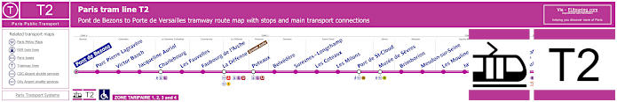
Paris tram line T2 map with tramway stations, transport connections and zones
However, here you have the Paris Tramway tram line T2, which travels from Pont de Bezons through to Porte de Versailles and it is this latter terminus you would need for the Dome de Paris at only around 200 metres from the entertainment venue, yet as you can see from the maps and timetables, this is also how to get to the Grande Arche in La Defense area of Paris and several other tourist attractions.
Paris tram line T2 stops:
Pont de Bezons, Parc Pierre - Lagravere, Victor Basch, Jacqueline Auriol, Charlebourg, Les Fauvelles, Faubourg de l'Arche, La Defense (Grande Arche), Puteaux, Belvedere, Suresnes - Longchamp, Les Coteaux, Les Milons, Parc de St-Cloud, Musee de Sevres, Brimborion, Meudon-sur-Seine, Les Moulineaux, Jacques-Henri Lartigue, Issy - Val de Seine, Henri Farman (Porte de Seine), Suzanne Lenglen, Porte d’Issy, Porte de Versailles (Parc des Expositions).
Paris tram line T2 main transport connections:
Metro Lines: 1, 8, 9, 10, 12. Train Lines: A, C, L, U. Tram Line: T3a.
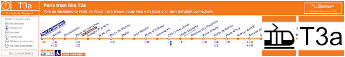
Paris tram line T3a map with tramway stations, transport connections and zones
Also within approximately 200 metres of Le Dome de Paris - Palais des Sports via the Porte de Versailles - Parc des Exposition stop, you have the Tram line T3a that travels between Pont du Garigliano - Hopital Europeen Georges Pompidou and Porte de Vincennes and as the name of the tram stop we mentioned earlier suggests, this is also how to get to the Pac des Expositions Paris Expo exhibition centre, which you can see from the tram maps and timetables.
Paris tram line T3a stops:
Pont de Garigliano (Hopital Europeen G. Pompidou), Balard, Desnouettes, Porte de Versailles (Parc des Expositions), Georges Brassens, Brancion, Porte de Vanves, Didot, Jean Moulin, Porte d’Orleans, Montsouris, Cite Universitaire, Stade Charlety (Porte de Gentilly), Poterne des Peupliers, Porte d’Italie, Porte de Choisy, Porte d’Ivry, Maryse Bastie, Avenue de France, Baron Le Roy, Porte de Charenton, Porte Doree, Montempoivre, Alexandra David-Neel, Porte de Vincennes.
Paris tram line T3a main transport connections:
Metro Lines: 1, 4, 7, 8, 12, 13, 14. Train Lines: B, C. Tram Lines: T2, T3b, T9.
Paris bus line 15 Traverse Brancion-Commerce with stops, connections and street plan
Run by the transport company B E Green and Autocars Dominique in conjunction with Keolis, the bus line La Traverse Brancion-Commerce, also referred to as Traverse B-C and bus line 15, travels in a complete circuit from Parc Georges Brassens covering bus stops within the 15th Arrondissement of Paris, and as you can see from the maps with information and timetables, there is a bus stop called Petite Ceinture for getting close to Le Dome de Paris.
Paris bus line 15 Traverse Brancion-Commerce stops:
Parc Georges-Bressons, Avenue Bartholome, Brancion, Chauvelot, Fizeau, Morillons, Labrouste Vouille, Paul Barrruel, Bargue, Volontaire-Vaugirard, Pasteur Docteur Roux, Institut Pasteur, Procession, Alleray, Place d'Alleray, Mediatheque Yourcenar, Convention, Vaugirard, Mairie du 15, Square St Lambert, Rue des Entrepreneurs, Felix Faure, Javel Felix Faure, Croix-Nivert, Lecourbe, Convention Vaugirard, Dombasle, Olivier de Serres, Maison des associations, Petite ceinture, Thureau-Dangin.
Paris bus line 15 Traverse B-C main transport connections:
Metro lines: 6, 8, 12, 13. Tram lines: T3a. Bus lines: 39, 62, 70, 80, 88, 89, 95.
Paris bus 15 Traverse Brancion-Commerce route maps available:
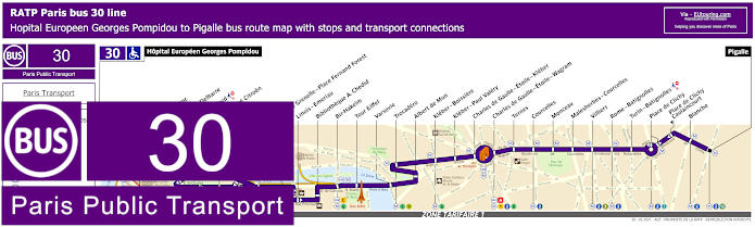
RATP Paris bus line 30 with stops, connections and route plan
Here we have the Paris bus line 30 run by the transport company RATP, which travels from Pigalle to Hopital Europeen Georges Pompidou, and as you can see from the street maps and timetables this is one options for how to get to the Eiffel Tower via the Tour Eiffel stop, yet for getting the entertainment venue called Le Dome de Paris - Palais des Sports, you would need to utilise the Place Balard bus stop, which is a walk of approximately 800 metres.
Paris bus line 30 stops:
Hopital Europeen Georges Pompidou, Rue Leblanc, Leblanc - Delbarre*, Place Balard, Parc Andre Citroen, Cauchy, Javel, Pont de Grenelle-Place Fernand Forest*, Linois - Emeriau*, Bibliotheque A. Chedid*, Bir-Hakeim, Tour Eiffel, Varsovie, Trocadero, Albert de Mun, Kleber - Boissiere, Kleber - Paul Valery, Charles de Gaulle - Etoile - Kleber, Charles de Gaulle - Etoile - Wagram, Ternes, Courcelles, Monceau, Malesherbes - Courcelles, Villiers, Rome - Batignolles, Turin - Batignolles, Place de Clichy, Place de Clichy - Caulincourt**, Blanche, Pigalle.
* Served in direction of Pigale ** Served in direction of Hopital Europeen Georges Pompidou
Paris bus line 30 main transport connections:
Metro Lines: 1, 2, 3, 6, 8, 9, 10, 12, 13. Train Lines: A, C. Tram Line: T3a.
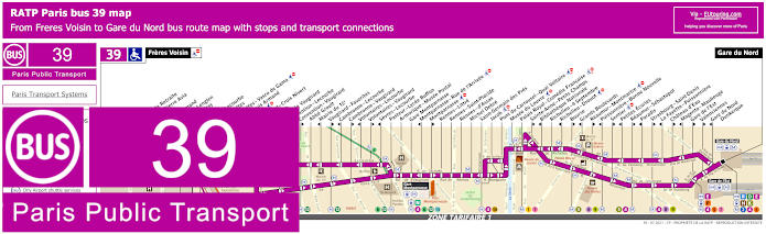
RATP Paris bus line 39 with stops, connections and street plan
As you will see from the street maps and timetables for the Paris bus line 39, there are numerous bus stops that are direction dependant of ten due to one way traffic, therefore if you are using this bus route to get to Le Dome de Paris you would need the Desnouttes bus stop if travelling in the direction of central Paris and Gare du Nord train station, or it would be the Balard stop if travelling out towards Freres Voisin.
Paris bus line 39 stops:
Freres Voisin, Maison de Retraite**, Colonel Pierre Avia*, Severine**, Louis Armand*, Suzanne Lenglen*, Porte d’Issy**, Balard*, Balard - Lecourbe*, Desnouettes**, Desnouettes - Vasco de Gama**, Lycee Louis Armand*, Hameau**, Duranton**, Hopital de Vaugirard**, Convention - Lecourbe*, Convention - Vaugirard**, Abbe Groult, Mairie du 15e*, Vaugirard - Favorites**, Cambronne - Lecourbe*, Cambronne - Vaugirard**, Volontaires - Lecourbe*, Volontaires - Vaugirard**, Sevres - Lecourbe*, Pasteur - Lycee Buffon, Armorique - Musee Postal, Gare Montparnasse, Montparnasse - Rue de l’Arrivee*, Montparnasse**, Rennes - Littre, Rennes - Saint-Placide, Rennes - d’Assas, Michel Debre, Saint-Germain des Pres, Jacob, Pont du Carrousel - Quai Voltaire, Musee du Louvre, Palais Royal - Comedie Francaise, Sainte-Anne - Petits Champs**, Bibliotheque Nationale*, Richelieu - 4 Septembre, Richelieu - Drouot*, Bourse**, Grands Boulevards*, Reaumur - Montmartre**, Poissonniere - Bonne Nouvelle*, Sentier**, Petites Ecuries*, Reaumur - Sebastopol**, Paradis*, Strasbourg - Saint-Denis**, La Fayette - Poissonniere*, Chateau d'Eau**, Magenta - Maubeuge*, Gare de l'Est**, Valenciennes**, Gare du Nord - Dunkerque*, Gare du Nord.
* Served in the direction of Freres Voisin ** Served in the direction of Gare du Nord
Paris bus line 39 main transport connections:
Metro lines: 1, 2, 3, 4, 5, 6, 7, 8, 9, 10, 12, 13. Train lines: B, D, E, H, K, N, P. Tram lines: T2, T3a.
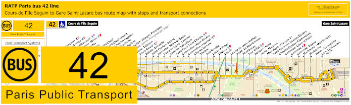
RATP Paris bus line 42 with stops, connections and street plan
However, these maps and timetables show the RATP bus line 42 that travels from Paris Gare Saint-Lazare train station through to Cours de l'Ile Seguin, which is one of the options for getting to La Seine Musicale entertainment venue, but for Le Dome de Paris - Palais des Sports events venue you would need the Place Balard bus stop, which is the same scenario for the Paris Expo.
Paris bus line 42 stops:
Cours de l'Ile Seguin, Parch de Billancourt, Place Jules Guesde, Marche de Billancourt, Marcel Sembat - Metro, Rene Descartes, Henri Martin, Porte de Saint-Cloud, Porte de Saint-Cloud-Murat, Versailles - Chardon Lagache, Versailles Exelmans, Pont du Garigliano, Hopital Europeen - Georges Pompidou, Rue Leblanc (Entree Principale de l'Hop.), Leblanc - Delbarre**, Place Balard, Balard - Lecourbe*, Saint-Charles - Balard**, Lecourbe - Vasco de Gama*, Vasco de Gama - Lourmel*, Lourmel - Felix Faure*, Rond-Point Saint-Charles**, Convention - Saint-Charles**, Convention - Lourmel*, Charles Michels, Theatre, Rue Rouelle, Docteur Finlay**, Dupleix, Desaix, Champ de Mars - Suffren, Rapp - La Bourdonnais, Monttessuy, Tour Eiffel, Bosquet - Rapp, Alma - Marceau, Montaigne - Francois 1er, Rond-Point des Champs-Elysees, Champs-Elysees - Clemenceau, Concorde - Cours la Reine, Concorde*, Concorde - Royale**, Madeleine - Malesherbes*, Madeleine*, Havre - Haussmann, Gare Saint-Lazare - Havre*, Gare Saint-Lazare.
* Stop served in the direction of Cours de l'Ile Seguin. ** Stop served in the direction of Gare Saint-Lazare.
Paris bus line 42 main transport connections:
Metro Lines: 1, 3, 6, 8, 9, 10, 12, 13, 14. Train Lines: C, E, J, L. Tram Line: T3a.
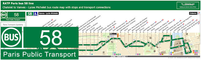
RATP Paris bus line 58 with stops, connections and street plan
Although the bus line 58 travels from Vanves - Lycee Michelet through to Chatelet, which is a major transport hub for getting to Paris tourist attractions and entertainment venues like Le Duc des Lombards Jazz Club, the unusual Pompidou Centre, etc, yet for the Dome de Paris you would need the Carrefour Albert Legris bus stop, which is around a 1400 metre walk from this events venue.
Paris bus line 58 stops:
Vanves - Lycee Michelet, Carrefour Albert Legris***, Jean Jaures - Jean Bleuzen, Adolphe Pinard**, Pont de la Vallee, Porte de Vanves, Porte Didot - Lycee Raspail*, Porte de Chatillon*, Colonel Monteil**, Didot**, Jean Moulin*, Hopitaux Broussais et Saint-Joseph**, Hopital Notre-Dame de Bon Secours*, Alesia - Didot**, Alesia - Les Plantes*, Pernety**, Rue Benard*, Chateau**, Chateau - Mairie du 14e*, Losserand - Maine, Gaite***, Gare Montparnasse***, Montparnasse - Rue du Depart, Montparnasse - Cinemas*, Vavin, Brea - Notre-Dame-des-Champs*, Notre-Dame-des-Champs**, Raspail - Fleurus**, Fleurus**, Guynemer - Vavin* ***, Musee du Luxembourg***, Senat, Theatre de l'Odeon* ***, Saint-Germain - Odeon***, Mazarine*, Saint-Andre des Arts** ***, Pont Neuf - Quai des Gds Augustins, Saint-Michel**, Cite - Palais de Justice*, Pont Neuf - Quai du Louvre**, Chatelet - Q. de Gesvres**, Chatelet.
* Stop served in the direction of Vanves - Lycee Michelet. ** Stop served in the direction of Chatelet. *** Not accessible to those with reduced mobility.
Paris bus line 58 main transport connections:
Metro Lines: 1, 4, 6, 7, 10, 11, 12, 13, 14. Train Lines: A, B, C, D, N. Tram Line: T3a.
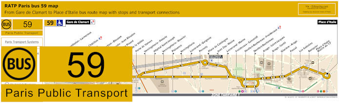
RATP Paris bus line 59 with stops, connections and street plan
Whereas the RATP bus line 59 travels from Gare de Clamart through to Place d'Italie and for Le Dome de Paris - Palais des Sports please take note of the maps and timetables carefully as you would need the Adolphe Pinard stop in one direction or the Pont de la Vallee stop in the other, which are around a 1700 metre walk.
Paris bus line 59 stops:
Gare de Clamart, Clos Montholon - Larmeroux, Stade, Rue de Chatillon, Diderot, Insurrection - Bleuzen, Jean Jaures - Jean Bleuzen, Adolphe Pinard, Pont de la Vallee, Porte de Vanves, Vercingetorix - Paturle, Hopital Saint-Joseph, Vercingetorix - Rouvier, Plaisance, Vercingetorix, Losserand - Gergovie, Pernety, Place de Catalogne, Jean Zay - Maine, Losserand - Maine, Froidevaux - Gassendi, Denfert-Rochereau - Froidevaux, Denfert-Rochereau, Arago - Saint-Jacques, Arago - Sante, Glaciere - Arago, Pascal, Les Gobelins, Banquier, Place d'Italie - Mairie du 13e, Place d'Italie.
Paris bus line 59 main transport connections:
Metro Lines: 4, 5, 6, 7, 13. Train Lines: B, N. Tram Line: T3a.
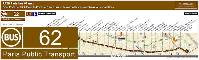
RATP Paris bus line 62 with stops, connections and street plan
As you can see from the maps and timetables, the bus line 62 is one of the options for how to get to Parc des Princes football stadium via the terminus of Porte de Saint-Cloud, and travelling through to Porte de France, for getting to Le Dome de Paris, you would need the bus stop called Cenvention - Vaugiraud at a walking distance of approximately 1000 metres from this well known entertainment venue.
Paris bus line 62 stops:
Porte de Saint-Cloud, Porte de Saint-Cloud - Murat, Porte de Saint-Cloud - Michel-Ange, Michel Ange-Varize, Versailles - Chardon - Lagache, Exelmans, Jouvenet, Michel-Ange - Molitor, Michel-Ange-Auteuil, Chardon - Lagache - Molitor, Eglise d’Auteuil, Wilhem - Versailles, Pont Mirabeau, Javel, Convention - Saint-Charles, Convention - Lourmel, Boucicaut, Convention - Lecourbe, Convention - Vaugirard, Place Charles Vallin, Brancion - Vouille, Labrouste, Vercingetorix, Plaisance - Hopital Saint-Joseph, Alesia - Didot, Les Plantes, Alesia - Jean Moulin, Alesia - General Leclerc, La Tombe Issoire, Rene Coty, Glaciere - Tolbiac, Vergniaud, Bobillot - Tolbiac, Moulin des Pres, Italie - Tolbiac, Choisy - Tolbiac, Tolbiac - Baudricourt, Olympiades, Patay - Tolbiac, Bibliotheque - Chevaleret, Bibliotheque Fr. Mitterrand, Bibliotheque - Rue Mann, Porte de France.
Paris bus line 62 main transport connections:
Metro Lines: 4, 7, 8, 9, 10, 12, 13, 14. Train Line: C. Tram Line: T3a.
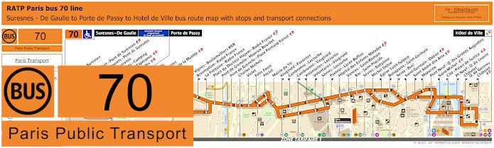
RATP Paris bus line 70 with stops, connections and route plan
Yet the RATP bus line 70 travels from Paris Hotel de Ville, which is the historical City Hall, through to Porte de Passy, yet on a Monday to Friday, the bus route also travels further on to Suresnes - De Gaulle, meaning this is an option for getting to Hippodrome de Longchamp horse racing course via Les Moulins - Camping stop, but for the Dome de Paris unfortunately the closest bus stop is Felix Faure at a distance of around 1400 metres, which is just under a mile.
Paris bus line 70 stops:
Suresnes - De Gaulle***, Mairie de Suresnes** ***, Henri IV** ***, Henri Sellier - Pont de Suresnes** ***, Rue des Bourets - Pont de Suresnes* ***, Pont de Suresnes** ***, Les Moulins - Camping***, Allee de l'Esperance***, Les Cascades***, Porte de Passy, Louis Boilly**, Avenue Ingres*, Chaussee de la Muette, Ranelagh*, Rodin*, Les Vignes - Boulainvilliers RER**, Assomption - Radio France**, La Fontaine - Radio France*, Place du Docteur Hayem - Radio France, Pont de Grenelle - Maurice Bourdet, Pont de Grenelle - Place Fernand Forest, Charles Michels, Violet, Felix Faure, Peclet, Mairie du 15e, Vaugirard - Favorites**, Cambronne - Lecourbe*, Cambronne - Vaugirard**, Volontaires - Lecourbe*, Volontaires - Vaugirard**, Sevres - Lecourbe, Pasteur - Lycee Buffon**, Hopital des Enfants Malades, Vaneau - Saint-Romain, Bac - Saint-Placide, Sevres - Babylone, Michel Debre, Eglise Saint-Sulpice*, Bonaparte - Saint-Germain**, Seine - Buci**, Saint-Germain - Odeon*, Saint Andre des Arts**, Mazarine*, Pont Neuf - Quai des Grands Augustins, Saint-Michel, Cite - Palais de Justice, Pt Neuf - Q du Louvre, Chatelet - Quai des Gesvres**, Chatelet*, Hotel de Ville.
* Served in Direction of Suresnes - De Gaulle or Porte de Passy. ** Served in direction of Paris Hotel de Ville. *** Only served on a Monday to Friday.
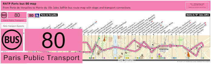
RATP Paris bus line 80 with stops, connections and street plan
These Paris bus maps with their timetables show the bus line 80 going from Mairie du 18e - Jules Joffrin through to Porte de Versailles, and as you can see, they show this being the stop for the Parc des Expositions, Paris Expo, which is right next to Le Dome de Paris - Palais des Sports, and the stop is literally just outside this entertainment venue, but on the return journey into Paris you could also utilise the Firmin Gillot bus stop.
Paris bus line 80 stops:
Porte de Versailles, Firmin Gillot**, Boulevard Victor*, Hameau*, Vaugirard - Croix Nivert**, Hopital de Vaugirard**, Duranton*, Convention - Lecourbe*, Convention - Vaugirard**, Abbe Groult, Vaugirard**, Mairie du 15e, Peclet**, Cambronne - Lecourbe*, Miollis*, Fondary**, Cambronne, La Motte-Picquet - Grenelle, General de Bollardiere, Ecole Militaire, Bosquet - Grenelle, Bosquet - Saint-Dominique, Bosquet - Rapp, Alma - Marceau, Montaigne - Francois 1er, Rond-Point des Champs-Elysees, Rd-Pt des Champs-Elysees - F. D. Roosevelt*, Rd-Pt des Champs-Elysees - Matignon**, Saint-Philippe du Roule*, Matignon - Saint-Honore**, Haussmann - Miromesnil**, La Boetie - Miromesnil*, Saint-Augustin, Pasquier - Anjou*, Gare Saint-Lazare - Rome, Europe, Bucarest, Place de Clichy, Place de Clichy - Caulaincourt*, Clichy - Caulaincourt**, Damremont - Caulaincourt, Square Caulaincourt, Lamarck - Caulaincourt, Custine - Mont-Cenis, Custine - Ramey*, Marcadet*, Mairie du 18e - Jules Joffrin.
* Stop served in direction of Porte de Versailles. ** Stop served in direction of Mairie du 18e - Jules Joffrin.
Paris bus line 80 main transport connections:
Metro Lines: 1, 2, 3, 6, 8, 9, 10, 12, 13, 14. Train Lines: C, E, J, L. Tram Lines: T2, T3a.
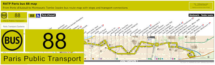
RATP Paris bus line 88 with stops, connections and street plan
You will find that the nearest bus stop to Le Dome de Paris utilising the Paris bus line 88 is called the Place Balard stop, and travelling between Porte d'Auteuil and Montsouris - Tombe Issoire, this is also a bus route that stops at Denfert-Rochereau, which is where the OrlyBus travels from for an option of getting to Orly Airport.
Paris bus line 88 stops:
Porte d'Auteuil, Porte Molitor, Exelmans, Versailles - Exelmans, Pont du Garigliano, Hopital Europeen Georges Pompidou, Rue Leblanc, Leblanc - Delbarre, Place Balard, Parc Andre Citroen, Cauchy, Javel, Emile Zola - Javel, Charles Michels, Violet, Felix Faure, Peclet, Mairie du 15e, Vaugirard, Vaugirard - Favorites, Alleray–La Quintinie, Cambronne - Vaugirard, Alleray, Procession, Falguiere, Institut Pasteur, Cotentin - Montparnasse 3, Pasteur - Falguiere, Montparnasse 2 - Gare TGV, Place de Catalogne, Jean Zay - Maine, Froidevaux - Gassendi, Denfert-Rochereau - Froidevaux, Denfert-Rochereau, Denfert-Rochereau - Metro - RER, Dareau - Rene Coty, Alesia - Rene Coty, Parc Montsouris, Jourdan - Montsouris, Montsouris - Tombe Issoire.
Paris bus line 88 main transport connections:
Metro Line: 4, 6, 8, 9, 10, 12, 13. Train Lines: B, C, N. Tram Line: T3a.
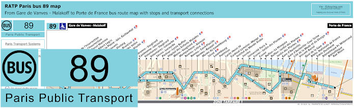
RATP Paris bus 89 map with stops, connections and street plan
Travelling from Gare de Vanves - Malakoff to Porte de France the RATP bus line 89 has numerous stops on route, but when you look at the maps and timetables, there are many that are direction dependant such as the Gare d'Austerlitz train station stops, but for Le Dome de Paris - Palais des Sports the nearest bus stop is called Georges Brassens that travels in both directions.
Paris bus line 89 stops:
Gare de Vanves - Malakoff, Carrefour de l'Insurrection**, Square de l'Insurrection, Avenue Marcel Martinie, Carrefour Albert Legris, Theatre de la Plaine - Gen. Guillaumat, Georges Brassens, Morillons - Dantzig, Morillons - Brancion*, Place Charles Vallin**, Brancion - Vouille, Alleray, Cambronne - Vaugirard, Cambronne - Lecourbe*, Volontaires - Vaugirard**, Volontaires - Lecourbe*, Sevres - Lecourbe*, Pasteur - Lycee Buffon**, Hopital des Enfants Malades*, Maine - Vaugirard, Montparnasse - Alencon, Rennes - Littre, Rennes - Saint-Placide, Rennes - Raspail, Musee du Luxembourg, Senat, Luxembourg, Pantheon, Lycee Henri IV, Cardinal Lemoine - Monge, Institut du Monde Arabe**, Jussieu*, Universite Paris 6**, Cuvier - Jardin des Plantes*, Cuvier**, Buffon - La Mosquee*, Buffon - Jardin des Plantes*, Jardin des Plantes**, Gare d’Austerlitz*, Gare d'Austerlitz - Cour Seine**, Cite de la Mode et du Design, Vincent Auriol, Quai de la Gare, Bibliotheque Nationale de France, Emile Durkheim*, Bibliotheque Francois Mitterrand, Bibliotheque - Rue Mann, Porte de France.
* Stop served in the direction of Gare de Vanves - Malakoff. ** Stop served in the direction of Porte de France.
Paris bus line 89 main transport connections:
Metro Lines: 4, 5, 6, 7, 10, 12, 13, 14. Train Lines: B, C, N. Tram Line: T3a.
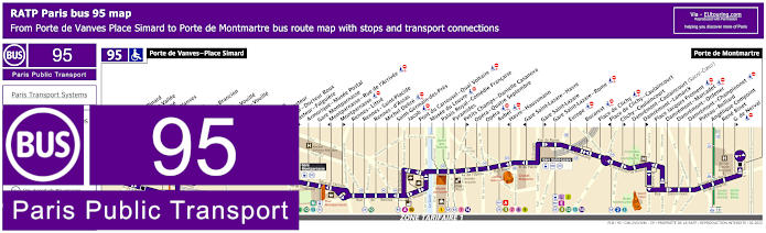
RATP Paris bus line 95 with stops, connections and street plan
However, this shows the Paris bus line 95 that travels between Porte de Vanves - Place Simard and Porte de Montmartre and this is one of the options for how to get to Palais Garnier Opera House along with many other tourist attractions like Sacre Coeur Basilica, but as you can see from the street maps and timetables, there are many bus stops which only travel in a certain direction and for Dome de Paris you would need the Brancion stop going one way or the Chauvelot stop going the other way into the heart of the city towards the Montmartre area.
Paris bus line 95 stops:
Porte de Vanves - Place Simard, Adolphe Pinard*, Pont de la Vallee*, Bartholome*, Porte de Vanves**, Brancion*, Chauvelot**, Morillons - Brancion*, Morillons**, Brancion - Vouille*, Labrouste - Vouille**, Alleray*, Falguiere**, Procession*, Institut Pasteur, Pasteur - Docteur Roux*, Pasteur - Falguiere**, Armorique - Musee Postal, Gare Montparnasse, Montparnasse - Rue de l'Arrivee*, Montparnasse**, Rennes - Littre, Rennes - Saint-Placide, Rennes - d'Assas, Michel Debre, Saint-Germain-des-Pres, Jacob, Pont du Carrousel - Quai Voltaire, Musee du Louvre, Palais Royal - Comedie Francaise, Pyramides, Petits Champs - Danielle Casanova**, Opera - Quatre Septembre, Opera, Auber, Havre - Haussmann*, Gare Saint-Lazare - Havre*, Gare Saint-Lazare**, Gare Saint-Lazare - Rome, Europe, Bucarest, Place de Clichy, Place de Clichy - Caulaincourt*, Clichy - Caulaincourt**, Damremont - Caulaincourt (Sacre-Coeur), Damremont - Lamarck**, Place Jacques Froment, Damremont - Marcadet, Damremont - Ordener, Damremont - Championnet, Poteau - Belliard, Angelique Compoint, Rene Binet, G. de Nerval**, Porte de Montmartre.
* Stop served in direction of Porte de Vanves - Place Simard. ** Stop served in direction of Porte de Montmartre.
Paris bus line 95 main transport connections:
Metro Lines: 1, 2, 3, 4, 6, 7, 8, 9, 10, 12, 13, 14. Train Lines: A, E, J, L, N. Tram Line: T3a.
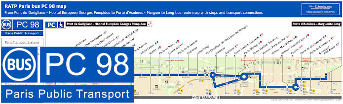
RATP Paris PC bus line 98 stops, connections and street plan
The bus line PC also referred to as bus line 98 is one of the options for how to get to the Palais des Congres event centre, and with the route going from Porte d'Asnieres - Marguerite Long, for the Dome de Paris you would need the opposite terminus of Pont du Garigliano - Hopital Europeen Georges Pompidou.
Paris PC bus line 98 stops:
Pont du Garigliano - Hopital Europeen Georges Pompidou, Versailles - Exelmans, Versailles - Chardon-Lagache, Porte de Saint-Cloud - Murat, Porte de Saint-Cloud*, Porte de Saint-Cloud - Michel Ange, Lycee Claude Bernard, Porte Molitor, Porte d'Auteuil, Alfred Capus, Raffet, Porte de Passy, Ernest Hebert, Porte de la Muette, Dufrenoy, Longchamp, Pte Dauphine - Mal De Lattre de Tassigny, Marbeau*, Alphand**, Porte Maillot - Malakoff*, Porte Maillot**, Porte Maillot - Pershing, Pereire - Porte Maillot, Ternes - Mac Mahon, Pereire - Marechal Juin*, Pereire**, Porte de Champerret, Porte de Courcelles, Gourgaud - Paul Adam, Porte d'Asnieres - Marguerite Long.
* Stop served in direction of Pont du Garigliano - Hopital Europeen Georges Pompidou. ** Stop served in direction of Porte d'Asnieres - Marguerite Long.
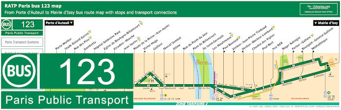
RATP Paris bus line 123 with stops, connections and street plan
Although as you can see from the maps and timetables for bus line 123, these are all within ticket tariff zone 2, but this is one of the options for how to get to Stade Roland Garros French Open tennis stadium from the outskirts of Paris, and going between Porte d'Auteuil and Mairie d'Issy, it is this latter terminus point that you would need for getting to Le Dome de Paris, which is a walk of approximately 1500 metres, or about 1 mile.
Paris bus line 123 stops:
Porte d'Auteuil, Porte Molitor, Stade Roland Garros, Rue des Pins, Gambetta, Hopital Ambroise Pare, Eglise de Boulogne-Billancourt, Escudier - Marche, Jean Jaures, Route de la Reine - Jean Jaures, Victor Hugo**, Gallieni, Marcel Sembat, Dome, Rue du Point du Jour, Pont de Billancourt, Ile Saint-Germain, Les Moulineaux, Paul Besnard**, Verdun - Jean-Pierre Timbaud**, Verdun - Docteur Lombard*, Chemin des Vignes, Paul Bert, Issy RER, Roger Salengro, Ferber - Gallieni**, Bourgain - General Gallieni*, Mediatheque**, Mairie d'Issy.
* Stop served in direction of Porte d'Auteuil. ** Stop served in direction of Mairie d'Issy.
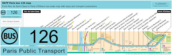
RATP Paris bus line 126 with stops, connections and street plan
So here you can see the bus line 126 travelling between Parc de Saint-Cloud and Porte d'Orleans with its many public transport connections on route, and for getting to Le Dome de Paris - Palais des Sports you would need the Corentin Celton bus stop, but we would like to point out that as you can see from the maps and timetables, this is ticket tariff zone 2.
Paris bus line 126 stops:
Parc de Saint-Cloud, La Colline**, Pont de Saint-Cloud - Rive Gauche**, Pont de Saint-Cloud - Albert Kahn, Rhin et Danube, Ancienne Mairie, Hotel de Ville de Boulogne-Billancourt, Marcel Sembat, Danjou, Rue du Point du Jour, Quai du Point du Jour, Issy - Val de Seine, President Robert Schuman, Victor Hugo, Corentin Celton, General de Gaulle, Place du Marechal de Lattre de Tassigny, Mairie de Vanves - Centre Administratif, Carrefour de l'Insurrection, Gare de Vanves - Malakoff, Gabriel Peri - Andre Coin, Pierre Larousse - Carrefour du 8 mai 1945, Pierre Brossolette - Gabriel Peri, Radiguey, Mairie de Montrouge, Cimetiere de Montrouge**, Gabrielle de Guerchy*, Porte d'Orleans.
* Stop served in direction of Parc de Saint-Cloud. ** Stop served in direction of Porte d'Orleans.
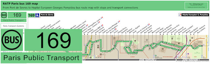
RATP Paris bus line 169 with stops, connections and street plan
Whereas this shows the maps and timetables for the bus line 169 that travels from Pont de Sevres in ticket tariff zone 3 through to Hopital Europeen Georges Pompidou in zone 1, which is an option for getting to the Musee de Sevres via a stop of the same name, as well as Le Dome de Paris via the Balard bus stop, but please be careful on what stop you choose for this entertainment venue as some others like Suzanne Lenglen, Place Balard and Porte d'Issy only travel in a specific direction.
Paris bus line 169 stops:
Pont de Sevres, Musee de Sevres, Parc de Saint-Cloud, Brimborion - Division Leclerc, 11 Novembre, Gare de Bellevue, Jeanne d'Arc, Stalingrad, Rabelais, Eglise de Meudon, Trivaux - Vertugadins - Lycee, Trivaux - Vertugadins**, Lycee Rabelais* ***, D'Alembert - Vertugadins - Lycee** ***, Victor Hugo - Louvois** ***, Arthelon*, Val Fleury RER***, Andre Schock**, Paul Bert, Galliera - Saint-Philippe, Rue des Peupliers, Rivoli***, Fleury, Hopital Percy, Epinettes, E. Duploye, Defense - Egalite, Verdi, Gare de Clamart***, General de Gaulle, Rue du Fort, Musee, Mairie d'Issy, Victor Hugo, Maison de Retraite**, Freres Voisin*, Colonel Pierre Avia*, Severine**, Louis Armand*, Porte d'Issy**, Suzanne Lenglen, Balard, Place Balard**, Leblanc - Delbarre*, Rue Leblanc, Hopital Europeen G. Pompidou.
* Stop served in the direction of Pont de Sevres. ** Stop served in direction of Hopital Europeen Georges Pompidou. *** Stop not accessible to those with reduced mobility.
Paris bus line 169 main transport connections:
Metro lines: 8, 9, 12. Train lines: C, N. Tram lines: T2, T3a. Bus lines: 17, 30, 39, 39.34, 40, 42, 88, 123, 162, 171, 179, 190, 289, 290, 291, 323, 389, 426, 467, TIM (569), TUVIM (589).
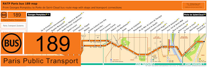
RATP Paris bus line 189 with stops, connections and street plan
Then you have the RATP bus line 189 with its maps and timetables, which travels between Gorges Pompidou in ticket tariff zone 3 to Porte de Saint-Cloud in zone 1, and as you can see, you have the option of the Corentin Celton bus stop or the Victor Hugo bus stop for getting to Le Dome de Paris - Palais des Sports.
Paris bus line 189 stops:
Georges Pompidou, Ile de France, Cimetiere Intercommunal, Eugene Beaujard**, Jardin Parisien - Hopital A. Beclere, Jardin Parisien - Coquelicots, Soleil Levant, Cimetiere, Plessis - Piquet, Marche, Centre Culturel Jean Arp*, Gabriel Peri, Pierre Louvrier, Lazare Carnot, Hebert - Gare, Clos Montholon, Stade, Rue de Chatillon, Republique, Pl. du Mar. de Lattre de Tassigny, General de Gaulle, Corentin Celton, Victor Hugo, President R. Schuman, Issy - Val de Seine RER, Quai du Point du Jour*, Voie Lactee*, Le Jour se Leve**, Abel Gance, Pierre de Coubertin, Porte de Saint-Cloud.
* Stop served in direction of Georges Pompidou. ** Stop served in direction of Porte de Saint-Cloud.
Paris bus line 189 main transport connections:
Metro Lines: 9, 12. Train Line: C. Tram Lines: T2, T6. Bus Lines: 22, 62, 72, 126, 175, 189, 190, 289, 290, 323, 389, 390, 394, Clamibus (579), PC (98), TUVIM (589).
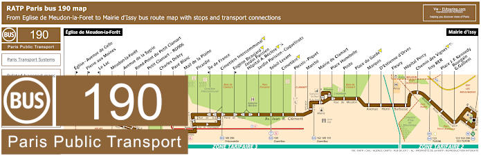
RATP Paris bus line 190 with stops, connections and street plan
Although this shows the bus line 190 that travels from Eglise de Meudon-la-Foret, and as you can see from the maps and timetables, the other terminus point is the Mairie d'Issy on the outskirts of the Paris region, Ile de France, and it is this bus stop you would need in order to get to the Dome de Paris entertainment venue.
Paris bus line 190 stops:
Eglise de Meudon-la-Foret, Eglise - Avenue de Celle**, Pierre aux Moines**, Le Lac*, Meudon-la-Foret, Avenue de la Sygrie, Rond-Point du Petit Clamart, Petit Clamart - RD906, Charles Debry, Pave Blanc, Mail de la Plaine, Picardie, Ile de France*, Cimetiere Intercommunal, Eugene Beaujard**, Jardin Parisien - Hopital A. Beclere, Jardin Parisien - Coquelicots, Soleil Levant, Cimetiere, Plessis - Piquet, Marche, Mairie de Clamart, Place Hunebelle, Poste, Place du Garde, Marquis, D'Estienne d'Orves, Fleury, Hopital Percy, Chemin des Vignes, Issy RER, Place J. F. Kennedy, Bourgain - G.Gallieni, Mairie d'Issy.
* Stop served in direction of Eglise de Meudon-la-Foret. ** Stop served in direction of Mairie d'Issy.
Paris bus line 190 main transport connections:
Metro line: 12. Train line: C. Tram line: T6. Bus lines: 123, 162, 169, 179, 189, 191, 290, 323, 379, 390, 475, ClamiBus (579), l'Hirondelle (597a), TUVIM (589).
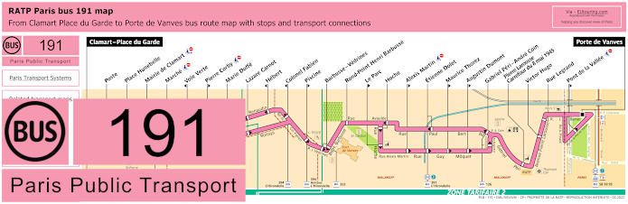
RATP Paris bus line 191 with stops, connections and street plan
Yet the RATP bus line 191 travels between Clamart - Place du Garde and Porte de Vanves, and as you can see from these bus maps and timetables there is the Rue Legrand bus stop that will get you to Dome de Paris, which travels in both directions, whereas the Pont de la Vallee bus stop only goes in the direction of Porte de Vanves.
Paris bus line 191 stops:
Clamart - Place du Garde, Poste, Place Hunebelle, Mairie de Clamart, Marche, Voie Verte*, Pierre Corby**, Marie Doffe, Lazare Carnot, Hebert*, Colonel Fabien*, Piscine**, Barbusse - Vedrines, Rond-Point Henri Barbusse, Le Parc**, Hoche, Alexis Martin**, Etienne Dolet, Maurice Thorez**, Augustin Dumont**, Gabriel Peri - Andre Coin, Pierre Larousse - Carrefour du 8 mai 1945, Victor Hugo, Rue Legrand, Pont de la Vallee**, Porte de Vanves.
* Stop served in direction of Clamart - Place du Garde. ** Stop served in direction of Porte de Vanves.
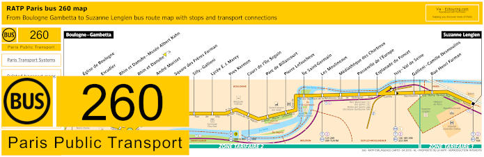
RATP Paris bus line 260 with stops, connections and street plan
So here you can see the bus maps and timetables for bus line 260 that travels between Boulogne - Gambetta and Suzanne Lenglen and it is this latter terminus point that you would required to get you with the closest walking distance of Dome de Paris rather than the stop before it of Rue Henri Farman, before the route goes further out.
Paris bus line 260 stops:
Boulogne - Gambetta, Eglise de Boulogne, Escudier, Rhin et Danube - Musee Albert Kahn, Rhin et Danube, Andre Morizet, Square des Freres Farman, Silly - Gallieni, Lycee E. J. Marey, Yves Kermen, Cours de l'Ile Seguin, Parc de Billancourt, Pierre Lefaucheux, Ile Saint-Germain, Les Moulineaux, Mediatheque des Chartreux, Passerelle de l'Europe, Esplanade du Foncet, Issy - Val de Seine, Gallieni - Camille Desmoulins, Rue Henri Farman, Suzanne Lenglen.
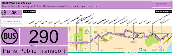
RATP Paris bus line 290 with stops, connections and street plan
However, this shows the RATP bus line 290 going from La Boursidiere passing through several communes, or areas, of the Paris region including Le Plessis-Robinson and Clamart before reaching the terminus of Issy - Vale de Seine RER, but please take note of the maps and timetables as the Mairie d'Issy stop you would need for getting to Dome de Paris stops at two different places depending upon your direction of travel.
Paris bus line 290 stops:
La Boursidiere, Reaumur, Pave Blanc, Newton**, Galilee, Langevin, Parc des Sports, Parc Technologique, Jardin Parisien - Hopital Antoine Beclere, Place du Garde, Marquis, Fleury, Hopital Percy, Epinettes, Defense - Egalite, Parc Henri Barbusse, Robespierre**, Andre Chenier**, Musee*, Mairie d'Issy, Marceau, President Robert Schuman, Gallieni - C. Desmoulins**, Issy - Val de Seine RER.
* Stop served in direction of La Boursidiere. ** Stop served in direction of Issy - Val de Seine RER.
Paris bus line 290 main transport connections:
Metro line: 12. Train line: C. Tram line: T2. Bus lines: 123, 126, 169, 179, 189, 190, 323, 379, 390, 394, 395, 595, Clamibus (579), TUVIM (589).
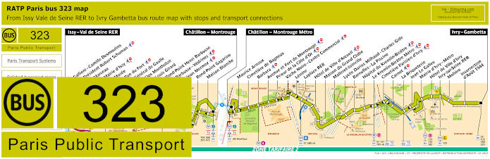
RATP Paris bus line 323 with stops, connections and street plan
Again, the RATP bus line 323 has bus stops called the Mairie d'Issy for getting to Le Dome de Paris, but one is on the Rue Diderot going in the direction of Issy - Val de Seine RER, and the other is on the Rue Kleber going in the direction of Ivry - Gambetta, as you can see from the 323 bus maps and timetables for this route.
Paris bus line 323 stops:
Issy - Vale de Seine RER, Gallieni - Camille Desmoulins*, President Robert Schuman, Marceau, Mairie d'Issy, Musee, Rue du Fort, General de Gaulle, Clos Montholon, Louis Girard, Rond-Point Henri Barbusse, Barbusse - Vedrines, Jean Mermoz, Rond-Point Gagarine, Maison Blanche, Chatillon - Montrouge, Chatillon - Montrouge Metro, Maurice Arnoux, Cimetiere de Bagneux, Barbara, Avenue et Fort de Montrouge, Prieur de la Cote d'Or, Vache Noire - Centre Commercial, Lenine**, Laplace RER, Hotel de Ville d'Arcueil, Maison du Grand Cedre, Malleret-Joinville, Lycee Darius Milhaud - Charles Gide, Barnufles - La Piscine, Hopital du Kremlin-Bicetre, Le Kremlin-Bicetre Metro, Cimetiere Parisien d'Ivry, Carnot, La Briqueterie, Jean Le Galleu, Mairie d'Ivry - Metro, Hotel de Ville d'Ivry, Ivry-sur-Seine RER, Moliere, Insurrection d'Aout 1944, Ivry - Gambetta.
* Stop served in direction of Issy - Vale de Seine RER. ** Stop served in direction of Ivry - Gambetta.
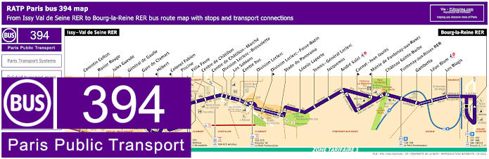
RATP Paris bus line 394 with stops, connections and street plan
Also travelling through various communes, or areas, including Paris, Chatillon, Malakoff, Fontenay-aux-Roses and Sceaux, the RATP bus line 394 has a route going from Issy - Vale de Seine RER through to Bourg-la-Reine RER and for getting to Le Dome de Paris - Palais des Sports you would need the Corentin Celton bus stop.
Paris bus line 394 stops:
Issy - Val de Seine RER, Corentin Celton, Rosier Rouge, Jules Guesde, General de Gaulle, Gare de Clamart, Hebert*, Colonol Fabien*, Piscine, Felix Faure, Centre de Chatillon, Centre de Chatillon - Marche, Division Leclerc - Brossolette, Les Sablons, Centre bus, Division Leclerc, Division Leclerc - Fosse-Bazin**, Stade du Panorama, Leonie Laporte, Tennis - General Leclerc, Jacquemin, Andre Salel, Carnot - Jean Jaures**, Mairie de Fontenay-aux-Roses*, Chateau Sainte-Barbe, Fontenay-aux-Roses RER, Gambetta, Leon Blum, Les Blagis, Bourg-la-Reine RER.
* Stop served in direction of Issy - Val de Seine RER. ** Stop served in direction of Bourg-la-Reine RER.
Paris bus line 394 main transport connections:
Metro Line: 12. Train Lines: B, C, N. Tram Lines: T2, T6. Bus Lines: 59, 126, 128, 169, 172, 189, 192, 194, 195, 197, 260, 290, 323, 388, 390, 475, Amibus (592), Clamibus (579), DM 151, Le Petit Fontenaisien (594), Paladin 6 7 17, TUVIM (589).
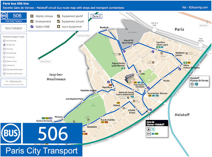
Paris Navette de Vanves bus line 506 with stops, connections and street plan
Here we have the bus line 506 that is also known as the Navette de Vanves line or Vanves line, which is run by the transport company Savac in conjunction with LCJ autocars, and as you can see from the maps and information, this travels in a complete circuit from Gare de Vanves - Malakoff, but for Dome de Paris entertainment venue you would need the Carrefour Albert Legris bus stop.
Paris bus line 506 stops:
Gare de Vanves - Malakoff, Insurrection - Bleuzen, Verdun, Metro Plateau de Vanves, Residence Danton, Carrefour Albert Legris, Marcel Yol - Henri Martin, Baudouin, Espace Murillo - Lycee Michelet, L’Ode, Insurrection - Cimetiere, Centre administratif - Mairie de Vanves, Republique, Valentine Jacquet, Jean-Baptiste Potin, Mansart, General de Gaulle, Clos Montholon - Larmeroux, Stade, Baudelaire, Rue de Chatillon, Diderot, Aristide Briand, Gare de Vanves - Malakoff.
Paris bus line 506 main transport connections:
Metro line: 13. Train line: N. Bus lines: 58, 59, 89, 126, 169, 189, 323, 391, 394.
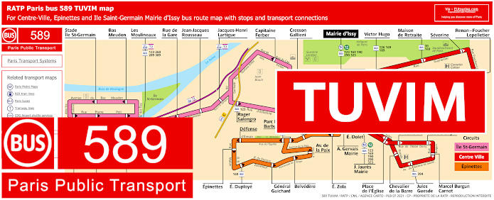
RATP Paris TUVIM bus line 589 with stops, connections and street plan
Additionally, you have the bus line 589 run by RATP, which is also known as the TUVIM line and as you can see from the maps and timetables, there are actually three separate routes that go in complete circuits from the Mairie d'Issy, which is the point you need for Dome de Paris, and there is the Red line called Centre Ville that also stops at Corentin Celton, Victor Hugo and Severine bus stops, whereas the blue Ile St-Germain and green Epinettes lines travel in different directions further out from this entertainment venue.
Paris bus line 589 stops TUVIM Centre-Ville (Red Line):
Mairie d'Issy, J. Jaures Mairie, Place de l'Eglise, Place d'Alembert, Abbe Derry, Marcel Burgun - Carnot, Jules Guesde, Chevalier de la Barre, Etienne Dolet, Mairie d'Issy - Diderot, Victor Hugo, Maison de Retraite, Severine, Renan - Foucher Lepelletier, Maurice Hartmann, College Henri Matisse, Corentin Celton, General Leclerc - Vaudetard, Mairie d'Issy - Horace Vernet.
Paris bus line 589 main transport connections (Red Line):
Metro line: 12. Bus lines: 39, 123, 126, 169, 189, 190, 290, 323, 394, TUVIM Pink, Bus TUVIM Orange.
Paris bus line 589 stops TUVIM Epinettes (Orange Line):
Mairie d'Issy - Horace Vernet, Mairie d'Issy, A Gervais - Mairie, E Zola, Robespierre, Parc H Barbusse, Defense, Epinettes, E Duploye, General Guichard, Belvedere, Av de la Paix, Robespierre, A Chenier, Mairie d'Issy.
Paris bus line 589 main transport connections (Orange Line):
Metro line: 12. Bus lines: 123, 169, 190, 290, 323, TUVIM Red, TUVIM Red, TUVIM Pink.
Paris bus line 589 stops TUVIM Ile Saint-Germain (Pink Line):
Mairie d'Issy, Cresson - Gallieni, Capitaine Ferber, Jacques-Henri Lartigue, Jean-Jacques Rousseau, Rue de la Gare, Les Moulineaux, Bas Meudon, Stade Ile Saint-Germain, Sainte-Eudoxie, Allee des Moulineaux, Pierre Poli, Roger Salengro, Mairie d'Issy - Gare routiere.
Paris bus line 589 main transport connections (Pink Line):
Metro line: 12. Tram line: T2. Bus lines: 123, 169, 190, 260, 289, 290, 323, 389, TUVIM Red, TUVIM Orange.
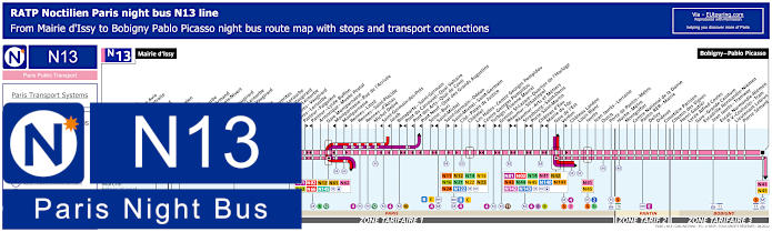
Paris Noctilien night bus N13 map with stops and transport connections
The Noctilien are the Paris night bus lines that operate between the hours of around 12:30am through to 5:30am, and here you can see the maps and timetables for the Noctilien N13 night bus line that travels from Bobigny - Pablo Picasso through to Mairie d'Issy, which is the stop you would need for Dome de Paris, yet this is also an option for other entertainment venues like getting to Zenith Paris or the Grande Halle de la Villette, both via the Porte de Pantin bus stop.
Paris night bus line N13 stops:
Mairie d'Issy, Victor Hugo, Freres Voisin*, Colonel Pierre Avia*, Maison de Retraite**, Severine**, Louis Armand*, Porte d'Issy**, Suzanne Lenglen*, Balard*, Firmin Gillot**, Balard - Lecourbe*, Lycee Louis Armand*, Duranton*, Vaugirard - Croix Nivert**, Hopital de Vaugirard**, Convention - Lecourbe*, Convention - Vaugirard**, Abbe Groult, Mairie du 15e*, Vaugirard - Favorites**, Cambronne - Lecourbe*, Cambronne - Vaugirard**, Volontaires - Lecourbe*, Volontaires - Vaugirard**, Sevres - Lecourbe*, Pasteur - Falguiere**, Pasteur - Lycee Buffon*, Armorique - Musee Postal, Gare Montparnasse, Montparnasse - Rue de l'Arrivee*, Montparnasse**, Rennes - Littre, Rennes - Saint-Placide, Rennes - d'Assas, Michel Debre, Saint-Germain-des-Pres*, Jacob*, Bonaparte - Saint-Germain**, Pont du Carrousel - Quai Voltaire*, Pont des Arts - Quai Conti*, Pont Neuf - Quai des Grands Augustins*, Seine - Buci**, Saint-Michel*, Saint-Germain - Odeon**, Saint-Michel - Saint-Germain**, Cite - Palais de Justice, Chatelet, Les Halles - Centre Georges Pompidou**, Centre Georges Pompidou*, Turbigo - Etienne Marcel**, Grenier St-Lazare - Quartier de l'Horloge*, Reaumur - Sebastopol**, Reaumur - Arts et Metiers*, Strasbourg - Saint-Denis**, Porte Saint-Martin*, Chateau d'Eau**, Mairie du 10e*, Gare de l'Est, Verdun**, Chateau Landon, Louis Blanc, Jaures, Jean Jaures - Lorraine, Ourcq, Porte de Pantin - Metro, Hoche - Metro, Montgolfier, Centre National de la Danse, Pantin RER - Mairie, Delizy, Diderot, Cimetiere Parisien, Chemin des Vignes, Henri Gautier, Lycee Alfred Costes, Gare - Grande Ceinture, Escradille Normandie-Niemen - Jean Jaures - Tramway, Escadrille Normandie-Niemen - Paul Vaillant-Couturier - Tram, Lieutenant Lebrun, Pierre Semard, Bobigny - Pablo Picasso.
* Only served in the direction of Mairie d'Issy. ** Only served in the direction of Bobigny - Pablo Picasso.
Paris night bus line N13 main transport connections:
Paris Noctilien night bus N62 map with stops and transport connections
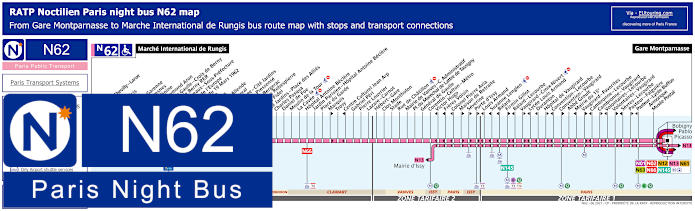
Whereas here you have the maps and timetables for Noctilien bus line N62 that travels from Gare Montparnasse train station through to Marche International de Rungis, which is largest wholesale food market in the world, and for Le Dome de Paris you would need the Corentin Celton or General de Gaulle bus stops going in either direction, although if you are heading back to Paris after a night out, then you could also utilise the Firmin Gillot bus stop, as this night bus stop along with several others only travel in a specific direction.
Paris night bus line N62 stops:
Marche International de Rungis, Mairie de Cheville - Larue, Le Delta, Parc Medicis, Montjean, Le Clos la Garenne, Le Petit Fresnes, Docteur Tenine, Berny - Raymond Aron, General de Gaulle - Croix de Berny**, La Croix de Berny RER*, Parc de Sceaux - Sous-Prefecture, Carrefour de l'Europe, Carrefour du 19 Mars 1962, La Briaude, Les Vallees, President Allende**, General Duval, Butte Rouge - Cite Jardins, Francis de Pressense, Cyrano de Bergerac, Maximilien Robespierre, Moulin Fidel, Cite Jardins - Place des Allies, Charles Pasqua, Daniel de Foe, Moulin de la Tour, La Cavee, Hopital Antoine Beclere, Jardin Parisien - Hopital Antoine Beclere, Place du Garde, Marquis**, Trosy, Centre Cultural Jean Arp*, Gabriel Peri, Pierre Louvrier, Lazare - Carnot, Hebert - Gare, Clos Montholon, Stade, Rue de Chatillon, Mairie de Vanves - C. Administratif, Place du Marechal de Lattre de Tassigny, General de Gaulle, Corentin - Celton - Metro, Victor Hugo*, Freres Voisin*, Colonel Pierre Avia*, Maison de Retraite**, Severine**, Porte d'Issy**, Louis Armand*, Suzanne Lenglen*, Balard*, Firmin Gillot**, Balard - Lecourbe*, Vaugirard - Croix-Nivert**, Lycee Louis Armand*, Duranton*, Hopital de Vaugirard**, Convention - Lecourbe*, Convention - Vaugirard**, Abbe Groult, Mairie du 15e*, Vaugirard - Favorites**, Cambronne - Lecourbe*, Cambronne - Vaugirard**, Volontaires - Lecourbe*, Volontaires - Vaugirard**, Sevres - Lecourbe*, Pasteur - Falguiere**, Pasteur - Lycee Buffon*, Amorique - Musee Postal, Gare Montparnasse.
* Stop served in direction of Marche International de Rungis. ** Stop served in direction of Gare Montparnasse.
Paris night bus line N62 main transport connections:
Paris Noctilien night bus N63 map with stops and transport connections
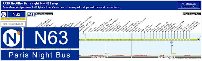
Again travels from ticket tariff zone 1 in Paris at Gare Montparnasse train station, the Noctilien N63 night bus line goes through communes such as Chatillon and Chatenay-Malabry before reaching Polytechnique Vauve in zone 4, but for Le Dome de Paris - Palais des Sports you would need the Plateau de Vanves stop for either direction or the Pont de la Vallee night bus stop if heading back into Paris.
Paris night bus line N63 stops:
Gare Montparnasse, Gare Montparnasse*, Armorique - Musee Postal, Montparnasse 2 - Gare TGV, Jean Zay - Maine**, Losserand - Maine**, Pernety, Vercingetorix*, Plaisance**, Porte de Vanves, Pont de la Vallee**, Plateau de Vanves, Rue Etienne Dolet, Chatillon - Montrouge, P.Semard - Chatillon - Montrouge**, Pierre Semard*, Republique - Deforges, Republique - Liberte, Liberte, Cimetiere, Theatre des Sources, Boulevard de la Republique, Augustin Claude, Carrefour des Mouilleboeufs, Robinson RER, Professeur Einstein, Marc Sangier, Jean Jaures, Docteur Le Savoureux, Jules Verne, President Allende, Faculte de Pharmacie, Groupe Scolaire Sophie Barat, Les Antes, Le Clos, Paron, Foch - Leclerc, Grands Chenes**, Carnot, Vallee de la Bievre, Emile Zola, Boulevard du 1er Mai, Georges Mandel, Lycee de Vilgenis, President Allende, Les Ruelles, Massy - Palaiseau RER, Palaiseau Ville, La Vallee, Camille Claudel, ENSTA - Joncherettes, Polytechnique Lozere, Ferme de la Vauve, Polytechnique Vauve.
* Bus stop served in direction of Polytechnique Vauve. ** Bus stop served in direction of Gare Montparnasse.
Paris night bus line N63 main transport connections:
Metro lines: 4, 6, 12, 13. Train lines: B, C, N, TGV. Tram lines: T3a, T6. Bus lines: N01, N02, N12, N13, N61, N62, N66, N122, N145.
Paris Noctilien night bus N145 map with stops and transport connections
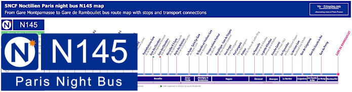
Whereas this shows the Noctilien N145 bus line travelling between Gare Montparnasse and Gare de Rambouillet stopping at many other train station and key points on its night bus route, but please take note of the maps and timetables carefully, as there are certain time only applicable to weekends and French national holidays in addition to the fact that the Porte de Versailles stop only goes to Paris, so if you wish to go further out to the Paris region of Ile de France, then you would need the Balard night bus stop.
Paris night bus line N145 stops:
Gare Montparnasse - Gare routiere Place Raoul Dautry***, Porte de Versailles - Rue de Vaugirard*, Balard - Avenue de la Porte de Sevres, Marcel Sembat - Avenue Paul Vaillant Couturier, Mairie de Sevres - Sevres Rive Gauche - Avenue de l'Europe, Hopital Jean Rostand - Grande Rue, Atrium - Avenue Roger Salengro, Puits Sans Vin - Chaville Rive Gauche - Av. Roger Salengro, Grace de Dieu - Av. General Leclerc, Gabriel Peri - Viroflay Rive Gauche - Av. du General Leclerc, Pierre Edouard - Avenue du General Leclerc, Porchefontaine Gare - Avenue de Paris, Gare des Chantiers - Place Raymond Poincare**, Gare des Chantiers - Rue des Chantiers*, Versailles Rive Gauche Gare - Avenue du General de Gaulle, Porte des Matelots - Rue de la Division Leclerc, La Poste - Saint-Cyr Gare - Avenue Pierre Curie, Saint-Quenin en Yvelines Gare - Gare Routiere, Groupe scolaire Pasteur - Avenue des Pres, Republique - Gare de Trappes - Av. Paul Vaillant Couturier, Yves Farges - Rue Paul Langevin, Paul Langevin - Place Paul Langevin, Pasteur - Boulevard du Pasteur M. Luther King, La Passerelle - Avenue de la Villedieu, La petite Villedieu - Avenue de la Villedieu, Franche Comte - Boulevard du 19 Mars 1962, Les Pyramides - Bd. Rene Ressejac Duparc, La Verriere Gare - Boulevard Guy Schuler, Gare de Coignieres, Gare des Essarts-le-Roi, Gare du Perray, Gare de Rambouillet.
* Stop served in the direction of Gare Montparnasse. ** Stop served in direction of La Verriere Gare or Gare de Rambouillet. *** For Gare de l'Est change to night bus line N01 or N02.
Paris night bus line N145 main transport connections:
Metro Lines: 4, 6, 12, 13. Train Line: N. Bus Lines: N01, N02, N12, N13, N61, N62, N63.
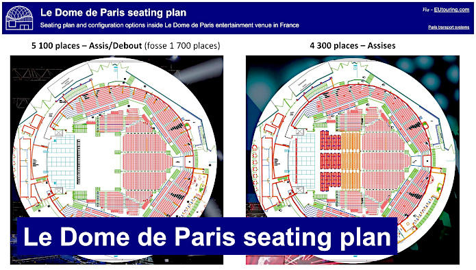
So here you can see plans for the Dome de Paris for the configuration layout depending upon the type of event that this Paris entertainment venue is hosting, and as you can see, the dome can cater for up to 5,100 people although only up to a maximum of 4,600 people seated depending upon the production, so when looking at booking a show, please bear these in mind.