How to get to Roland Garros tennis stadium in Paris using public transport
The Stade Roland Garros is home to the French Open tennis tournament held yearly starting during the month of May and ending in June with top players from all over the world attending this prestigious Grand Slam event, and below you can see how to get to Roland Garros via public transport with maps and timetables, along with information and a plan for parking and access, which can all be downloaded via PDF or image formats directly to your PC or mobile device.
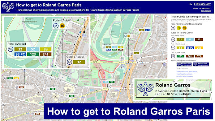
Roland Garros transport map of Metro lines, bus lines with stops, connections and street plan
This first map shows Roland Garros Paris tennis stadium and the various different bus stops and public transport connections that are all located within walking distance of the checkpoints to access Roland Garros, which is situated on the outskirts of Paris in the 16th Arrondissement.
How to get to Roland Garros public transport maps available:
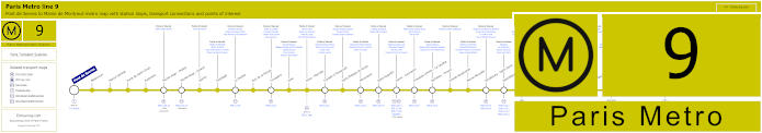
Paris Metro Line 9 map with stations, connections and points of interest
This shows the Paris Metro Line 9 maps travelling between Pont de Sevres and Mairie de Montreuil with various stops that have transport connections including the Michel-Ange - Molitor metro station that is within walking distance of the PPO Molitor checkpoint at Roland Garros tennis stadium.
Metro line 9 stops:
Pont de Sevres, Billancourt, Marcel Sembat, Porte de Saint-Cloud, Exelmans, Michel-Ange - Molitor, Jasmin, Ranelagh, La Muette, Rue de la Pompe, Trocadero, Iena, Alma - Marceau, Franklin D Roosevelt, Saint-Philippe-du-Roule, Miromesnil, Saint-Augustin, Havre - Caumartin, Chaussee d'Antin - La Fayette, Richelieu - Drouot, Grands Boulevards, Bonne Nouvelle, Strasbourg - Saint-Denis, Republique, Oberkampf, Saint-Ambrose, Voltaire, Charonne, Rue des Boulets, Nation, Buzenval, Maraichers, Porte de Montreuil, Robespierre, Croix de Chavaux, Mairie de Montreuil.
Metro line 9 main transport connections:
Metro Lines: 1, 2, 3, 4, 5, 6, 7, 8, 10, 11, 13, 14. Train Lines: A, C, E. Tram Lines: T2, T3b. Bus Line: RoissyBus.
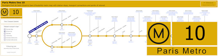
Paris Metro Line 10 map with stations, connections and points of interest
However, here is the Metro Line 10 that has a terminus of Boulogne - Pont de Saint-Cloud and at Gare d'Austerlitz train station in central Paris, but as you can see from the maps, the metro route serves a few stations only in a particular direction, which means getting from Paris to Roland Garros you would need the Porte d'Auteuil stop, but for the opposite direction you would need the Michel-Ange - Molitor metro station.
Metro line 10 stops:
Boulogne - Pont de Saint-Cloud, Boulogne - Jean Jaures, Porte d'Auteuil, Michel-Ange - Auteuil, Eglise d'Auteuil, Michel-Ange - Molitor, Chardon - Lagache, Mirabeau, Javel - Andre Citroen, Charles Michels, Avenue Emile Zola, La Motte-Picquet - Grenelle, Segur, Duroc, Vaneau, Sevres - Babylone, Mabillon, Odeon, Cluny - La Sorbonne, Maubert - Mutualite, Cardinal Lemoine, Jussieu, Gare d'Austerlitz.
Metro line 10 main transport connections:
Metro Lines: 4, 5, 6, 7, 8, 9, 10, 12, 13. Train Lines: B, C. Tram Line: T2.
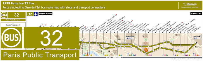
RATP Paris bus line 32 with stops, connections and street plan
You will find that the RATP Paris bus line 32 travels from Gare de l'Est train station to Porte d'Auteuil, which stops at the bus station very close to the PPO Auteuil security checkpoint at Roland Garros, which as you will find out later, is one of three designated checkpoints you will have to go through in order to access the stadium and its tennis courts, etc.
Paris bus line 32 stops:
Porte d'Auteuil, Gare d’Auteuil**, Alfred Capus, Raffet, Porte de Passy, Louis Boilly**, Avenue Ingres*, La Muette - Boulainvilliers, Passy - Boulainvilliers**, Place de Passy**, Place Possoz*, Jean Bologne**, La Tour*, Passy - La Tour**, Scheffer, Trocadero, Albert de Mun, Iena, Marceau - P. 1er de Serbie - Pl. de Beyrouth, Pierre Charron - Francois 1er, La Boetie - Champs-Elysees, Rd-Pt des Champs-Elysees - Matignon**, Saint-Philippe du Roule*, Matignon - Saint-Honore**, Haussmann - Miromesnil**, La Boetie - Miromesnil*, Saint-Augustin, Pasquier - Anjou*, Gare Saint-Lazare**, Rome - Haussmann*, Havre - Haussmann**, Havre - Caumartin*, Auber, Opera**, Chaussee d'Antin*, Choiseul**, Le Peletier - Haussmann*, Richelieu - Drouot**, Carrefour Chateaudun*, Cadet*, Square Montholon*, Grands Boulevards**, Poissonniere - Bonne Nouvelle**, Hauteville*, Porte Saint-Denis**, Chateau d’Eau**, Faubourg - Saint-Denis*, Gare de l'Est.
* Stop served in direction of Porte d'Auteuil. ** Stop served in direction of Gare de l'Est.
Paris bus line 32 main transport connections:
Metro Lines: 1, 3, 4, 5, 6, 7, 8, 9, 10, 12, 13, 14. Train Lines: C, E, J, L, P.
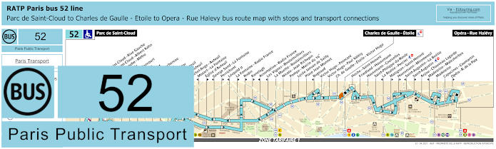
RATP Paris bus line 52 with stops, connections and route plan
The bus line 52 goes from Parc de Saint-Cloud through to Opera - Rue Halevy although there is only a partial service of an evening between Charles de Gaulle - Etoile, which is one of the ways for how to get to the Arc de Triomphe, and Porte d'Auteil, and this is the bus stop you would need to reach the Stade Roland Garros French Open tournament.
Paris bus line 52 stops:
Parc de Saint-Cloud, La Colline**, Pont de Saint-Cloud - Rive Gauche**, Pont de Saint-Cloud - Albert Kahn, Rhin et Danube - Metro, Rue de Silly, Rue de Billancourt, Jean Jaures, Rue de l’Est, Denfert-Rochereau, La Tourelle, Porte Molitor, Porte d’Auteuil***, Gare d’Auteuil, Michel-Ange - Auteuil, Mozart - La Fontaine*, Eglise d’Auteuil**, George Sand - La Fontaine*, Perrichont**, Leopold II*, La Fontaine - Radio France**, Rodin**, Ranelagh**, Assomption - Radio France*, Les Vignes - Boulainvilliers*, La Muette - Boulainvilliers, Nicolo - Jean Richepin, Pompe - Mairie du 16e, Lycee Janson de Sailly, Place Jean Monnet, Bugeaud, Victor Hugo - Poincare, Victor Hugo - Paul Valery, Charles de Gaulle - Etoile - Victor Hugo, Charles de Gaulle - Etoile - Friedland***, Hoche - Saint-Honore, Friedland - Haussmann, Haussmann - Courcelles, Saint-Philippe du Roule, La Boetie - Percier*, Matignon - Saint-Honore**, Haussmann - Miromesnil**, Saint-Augustin - La Boetie*, Saint-Augustin**, Anjou - Chaveau Lagarde, Madeleine - Malesherbes*, Madeleine, Capucines - Caumartin, Opera - Rue de la Paix**, Opera - Rue Halevy.
* Stop served in direction of Parc de Saint-Cloud. ** Stop served in direction of Opera - Rue Halevy. *** Only a partial service operates in the evening between Porte d'Auteuil and Charles de Gaulle Etoile - Friedland.
Paris bus line 52 main transport connections:
Metro Lines: 1, 2, 3, 6, 7, 8, 9, 10, 12, 13, 14. Train Lines: A, C. Tram Line: T2.
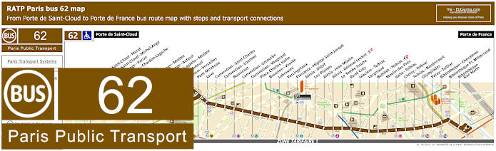
RATP Paris bus line 62 with stops, connections and street plan
Yet the bus line 62 also run by the transport company RATP, travels from Porte de Saint-Cloud to Porte de France, which is one option for getting to Bibliotheque Francois Mitterrand. But as you can see from the maps and timetables, many bus stops are only served in a certain direction including Michel-Ange - Molitor and Michel-Ange - Auteuil, which is great for getting back to other areas of Paris from Roland Garros, although you could utilise the Porte de Saint-Cloud stop.
Paris bus line 62 stops:
Porte de Saint-Cloud, Porte de Saint-Cloud - Murat, Porte de Saint-Cloud - Michel-Ange, Michel Ange-Varize, Versailles - Chardon - Lagache, Exelmans, Jouvenet, Michel-Ange - Molitor, Michel-Ange-Auteuil, Chardon - Lagache - Molitor, Eglise d’Auteuil, Wilhem - Versailles, Pont Mirabeau, Javel, Convention - Saint-Charles, Convention - Lourmel, Boucicaut, Convention - Lecourbe, Convention - Vaugirard, Place Charles Vallin, Brancion - Vouille, Labrouste, Vercingetorix, Plaisance - Hopital Saint-Joseph, Alesia - Didot, Les Plantes, Alesia - Jean Moulin, Alesia - General Leclerc, La Tombe Issoire, Rene Coty, Glaciere - Tolbiac, Vergniaud, Bobillot - Tolbiac, Moulin des Pres, Italie - Tolbiac, Choisy - Tolbiac, Tolbiac - Baudricourt, Olympiades, Patay - Tolbiac, Bibliotheque - Chevaleret, Bibliotheque Fr. Mitterrand, Bibliotheque - Rue Mann, Porte de France.
Paris bus line 62 main transport connections:
Metro Lines: 4, 7, 8, 9, 10, 12, 13, 14. Train Line: C. Tram Line: T3a.
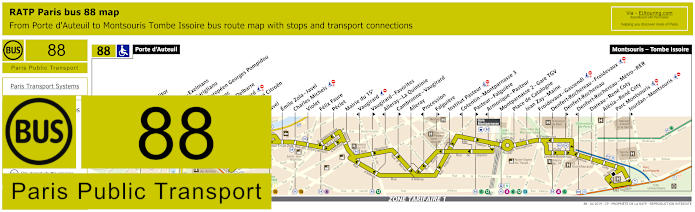
RATP Paris bus line 88 with stops, connections and street plan
However, the RATP bus line 88 goes between Porte d'Auteuil and Montsouris - Tombe Issoire, and for the French Open tennis tournament at Roland Garros, the Porte d'Auteuil bus station is situated very close to the PPO checkpoint for entry to the stadium, which runs daily from early morning until just after midnight even at weekends and on French holidays.
Paris bus line 88 stops:
Porte d'Auteuil, Porte Molitor, Exelmans, Versailles - Exelmans, Pont du Garigliano, Hopital Europeen Georges Pompidou, Rue Leblanc, Leblanc - Delbarre, Place Balard, Parc Andre Citroen, Cauchy, Javel, Emile Zola - Javel, Charles Michels, Violet, Felix Faure, Peclet, Mairie du 15e, Vaugirard, Vaugirard - Favorites, Alleray–La Quintinie, Cambronne - Vaugirard, Alleray, Procession, Falguiere, Institut Pasteur, Cotentin - Montparnasse 3, Pasteur - Falguiere, Montparnasse 2 - Gare TGV, Place de Catalogne, Jean Zay - Maine, Froidevaux - Gassendi, Denfert-Rochereau - Froidevaux, Denfert-Rochereau, Denfert-Rochereau - Metro - RER, Dareau - Rene Coty, Alesia - Rene Coty, Parc Montsouris, Jourdan - Montsouris, Montsouris - Tombe Issoire.
Paris bus line 88 main transport connections:
Metro Line: 4, 6, 8, 9, 10, 12, 13. Train Lines: B, C, N. Tram Line: T3a.
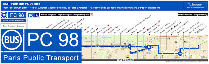
RATP Paris PC bus line 98 stops, connections and street plan
Although here you have the RATP bus route 98, which is also referred to as the Paris bus line PC that travels between Pont du Garigliano - Hopital Europeen Georges Pompidou and Porte d'Asnieres - Marguerite Long, and as you can see from the street maps with their timetables, you could opt for the Porte Molitor or the Porte d'Auteuil bus stops, both of which will get you within walking distance of the Stade Roland Garros checkpoints and entrances to the famous French tennis stadium.
Paris PC bus line 98 stops:
Pont du Garigliano - Hopital Europeen Georges Pompidou, Versailles - Exelmans, Versailles - Chardon-Lagache, Porte de Saint-Cloud - Murat, Porte de Saint-Cloud*, Porte de Saint-Cloud - Michel Ange, Lycee Claude Bernard, Porte Molitor, Porte d'Auteuil, Alfred Capus, Raffet, Porte de Passy, Ernest Hebert, Porte de la Muette, Dufrenoy, Longchamp, Pte Dauphine - Mal De Lattre de Tassigny, Marbeau*, Alphand**, Porte Maillot - Malakoff*, Porte Maillot**, Porte Maillot - Pershing, Pereire - Porte Maillot, Ternes - Mac Mahon, Pereire - Marechal Juin*, Pereire**, Porte de Champerret, Porte de Courcelles, Gourgaud - Paul Adam, Porte d'Asnieres - Marguerite Long.
* Stop served in direction of Pont du Garigliano - Hopital Europeen Georges Pompidou. ** Stop served in direction of Porte d'Asnieres - Marguerite Long.
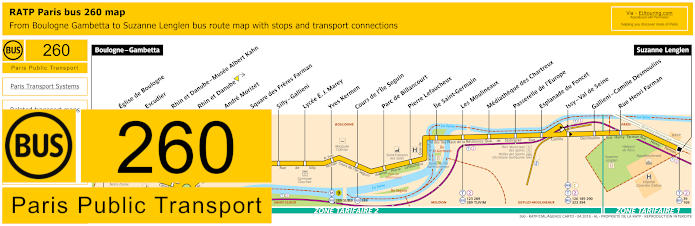
RATP Paris bus line 260 with stops, connections and street plan
Whereas this shows the RATP bus line 260 going from the outskirts of Paris at Suzanne Lenglen through to Boulogne - Gambetta, which as you can see from the maps with their timetables, shows the latter terminus very close to Stade Roland Garros and an entry point to many of the tennis courts including the Court Suzanne-Lenglen.
Paris bus line 260 stops:
Boulogne - Gambetta, Eglise de Boulogne, Escudier, Rhin et Danube - Musee Albert Kahn, Rhin et Danube, Andre Morizet, Square des Freres Farman, Silly - Gallieni, Lycee E. J. Marey, Yves Kermen, Cours de l'Ile Seguin, Parc de Billancourt, Pierre Lefaucheux, Ile Saint-Germain, Les Moulineaux, Mediatheque des Chartreux, Passerelle de l'Europe, Esplanade du Foncet, Issy - Val de Seine, Gallieni - Camille Desmoulins, Rue Henri Farman, Suzanne Lenglen.
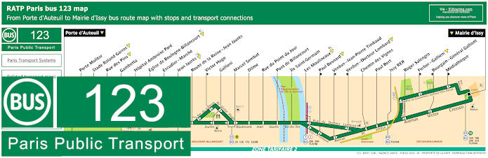
RATP Paris bus line 123 with stops, connections and street plan
This shows the bus line 123 travelling between Porte d'Auteuil and Mairie d'Issy, and when you look at the route maps you will see two bus stops mentioned called Stade Roland Garros and Rue des Pins, yet due to security measures put in place, the gates by these two stops are no longer in use for the French Open Roland Garros tennis tournament. Therefore, you would need the terminus point of Porte d'Auteil for one PPO checkpoint or the Gambetta stop to access the PPO Boulogne checkpoint for entry to the stadium.
Paris bus line 123 stops:
Porte d'Auteuil, Porte Molitor, Stade Roland Garros, Rue des Pins, Gambetta, Hopital Ambroise Pare, Eglise de Boulogne-Billancourt, Escudier - Marche, Jean Jaures, Route de la Reine - Jean Jaures, Victor Hugo**, Gallieni, Marcel Sembat, Dome, Rue du Point du Jour, Pont de Billancourt, Ile Saint-Germain, Les Moulineaux, Paul Besnard**, Verdun - Jean-Pierre Timbaud**, Verdun - Docteur Lombard*, Chemin des Vignes, Paul Bert, Issy RER, Roger Salengro, Ferber - Gallieni**, Bourgain - General Gallieni*, Mediatheque**, Mairie d'Issy.
* Stop served in direction of Porte d'Auteuil. ** Stop served in direction of Mairie d'Issy.
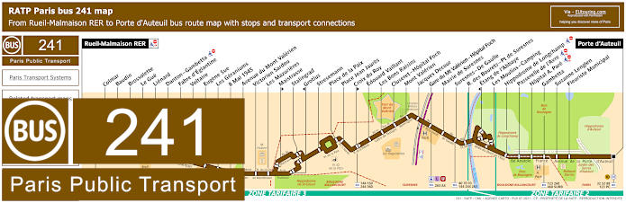
RATP Paris bus line 241 with stops, connections and street plan
Although here you have the bus line 241 that operates within the Paris region from Rueil-Malmaison RER to Porte d'Auteuil with numerous bus stops on route including one for how to get to Hippodrome de Longchamp horse racing course. Yet for the Stade Roland Garros even though the bus stops Suzanne Lenglen and Fleuriste Municipal are on the edge of the tennis stadium, to get nearest to the PPO security entry checkpoints you would need either the Porte d'Auteuil bus stop or the Gambetta bus stop by the Roland Garros PPO Boulogne checkpoint.
Paris bus line 241 stops:
Rueil-Malmaison RER, Colmar, Baudin, Brossolette, Le Gue, Lienard, Danton - Gambetta, Fabre d'Eglantine, Voltaire, Eugene Sue, Les Geraniums, 8 Mai 1945, Avenue du Mont Valerien, Victorien Sardou, Les Mazurieres, Maistrasse**, Stalingrad, Grotius*, Stresemann, Place de la Paix, Place Jean Jaures, Croix du Roy**, Edouard Vaillant, Les Bons Raisins, Cluseret - Hopital Foch, Mont Valerien, Jacques Decour, Gare du Mt Valerien - Hopital Foch, Mairie de Suresnes, Suresnes - De Gaulle, R. des Bourets - Pt de Suresnes, Etang de l'Abbaye*, Les Moulins - Camping, Hippodrome de Longchamp, Passerelle de l'Avre, Hopital A. Pare, Gambetta, Suzanne Lenglen, Fleuriste Municipal, Porte d'Auteuil.
* Stop served in direction of Rueil-Malmaison RER. ** Stop served in direction of Porte d'Auteuil.
Paris bus line 241 main transport connections:
Metro Line: 10. Train Lines: A, L, U. Bus Lines: 27, 32, 40, 52, 70, 88, 93, 98 (PC), 123, 144, 158, 160, 244, 260, 263, 360, 367, 460, 467, 4E, AS (544), SUBB (571).
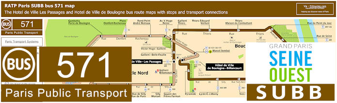
RATP Paris SUBB bus line 571 with stops, connections and street plan
And here we have the bus route SUBB, also referred to as RATP line 571, and as you can tell, there are two circuits, yet the bus stop you would need for Roland Garros tennis stadium is Gambetta - Porte de Boulogne on the Boucle Nord, or North Loop, which is the light brown colour running on a Monday to Friday.
Paris bus line 571 stops Boucle Nord:
Hotel de Ville de Boulogne, Marcel Sembat, Victor Hugo - Gallieni, Victor Hugo - Reine, Rond-point Andre Malraux, Place Denfert-Rochereau, Gambetta - Porte de Boulogne, Alsace Lorraine, Hopital Ambroise Pare, Parchamp, Parc Edmond de Rothschild, Dispensaire Saint-Denis, Saint-Denis - Anna Jacquin, Saint-Denis - Jean-Baptiste Clement, Rue de Silly - Rue de Paris, Silly - Morizet, Square des Freres Farman, Gallieni - Billancourt, Hotel de Ville - Les Passages.
Paris bus line 571 stops Boucle Sud:
Hotel de Ville - Les Passages, Gallieni - Belle-Feuille, Gallieni - Thiers, Thiers - Edouard Vaillant, Thiers - Maison du combattant, Rue du Point du Jour, Rue de Seine, Pont de Billancourt, Traversiere, Place Jules Guesde, Place Bir-Hakeim, Casteja, Yves Kermen, Lycee Marey, Pyramide, Hotel de Ville de Boulogne.
Paris bus line 571 main transport connections:
Metro Line: 9. Bus Lines: 42, 52, 72, 123, 126, 175, 260, 289, 389.
Roland Garros plans of car park locations, free shuttle buses, security checkpoints and restaurants
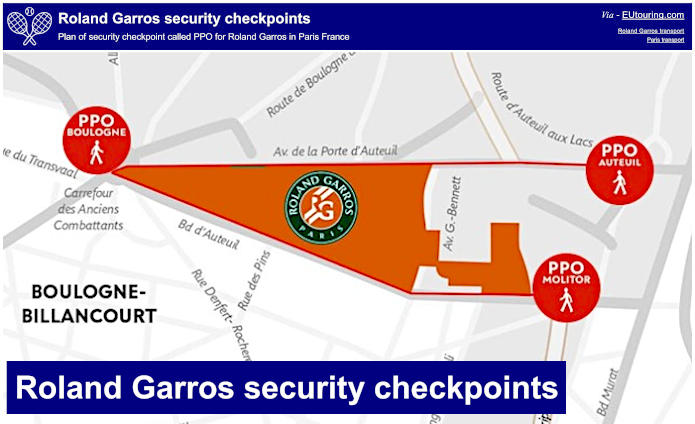
Roland Garros security checkpoints locations
The checkpoints are located close to public transport and taxi ranks, yet for those of you arriving in your own vehicle, then you will be pleased to know that there are various public car parks around Roland Garros along with parking for motorcycles and bikes.
Paris Roland Garros security checkpoints plans available:
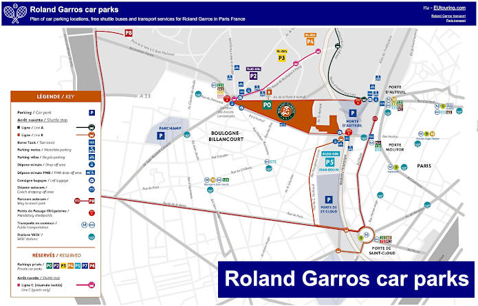
Roland Garros car park locations and free shuttle buses
Additionally, as you can see from this map, there are free shuttle bus services that will get you to one of the PPO points mentioned above for the Roland Garros French Open tennis tournament.
Some of these car parks are: * Parchamp car park, 7 ter, Rue du Parchamp 92100, Boulogne-Billancourt * Porte d'Auteuil car park (Carrefour), 1-3 Avenue du General Sarrail, 75016, Paris, * Point-du-Jour car park, Place Abel-Gance, 92200, Boulogne-Billancourt * Porte de Saint-Cloud car park (service station) 2 Avenue de la Porte de Saint-Cloud, 75016, Paris
However, there is also what are classed as Guest parking spaces for special services, those that have been invited, etc, which include P2, P3 and P4 located in the Bois de Boulogne, Paris and these are open until midnight, compared to many of the public car parks that are open 24 hours.
But keeping with arriving by car to Roland Garros, whether it be a taxi or a chauffeur service, there are specific drop-off points that must be adhered to and for PPO Auteuil this is in front of the fountain on Place de la Porte d’Auteuil, for PPO Molitor this is 2 Avenue de la Porte Molitor and PPO Boulogne is Route de Boulogne a Passy / Carrefour des Anciens Combattants.
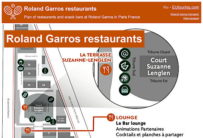
Roland Garros restaurants, snack bars and takeaway food venues
So here we have a plan showing the location of various types of food outlets including takeaway venues plus the restaurants and the terraces providing food and gourmet meals to take away or to eat on site. Yet it is also possible to order food to be delivered directly to your seat so that you do not have to miss any of the tennis action and this is available via iPhone or Android app by going to their website.
Paris Roland Garros restaurants and snack bars plans available:
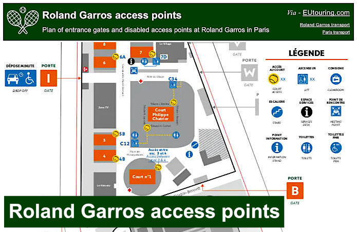
Roland Garros plan of disabled access points, entrances and gates
Here we have a plan of Roland Garros disabled access for wheelchair users and those persons with reduced mobility, and as you can see, this provides information on where the gates are located, with the ones in Orange being accessible to wheelchair users, not forgetting the location of the designated drop off point by Gate I for those of you who are registered disabled.
You will find that all tennis courts are accessible and the entry points and locations for the disabled and their designated carer are shown as a tennis ball, in addition to where the escalators and lifts are located along with disabled toilets, plus you will be pleased to know that all of the shops, stands and terraces with food outlets are also disabled friendly.
Paris Roland Garros disabled access points plans available:
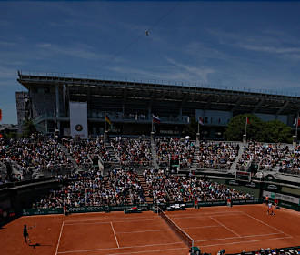
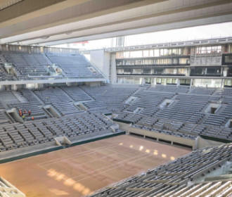
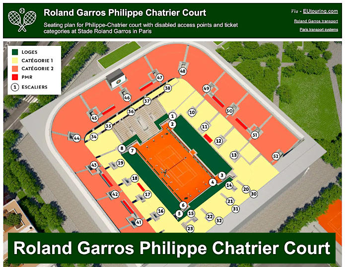
Roland Garros Philippe-Chatrier Court plan of stadium seating, disabled areas, ticket categories and access points
Originally just known as the central court from when it was first built in 1928, it is the main principal court at Roland Garros stadium and was renamed the Philippe Chatrier Court after a long time president of the French Tennis Federation, and as you can see from the above Roland Garros tennis court plan, this shows the different seating categories along with the areas for those persons with reduced mobility and wheelchair users in addition to all the access point to the tiers of this renowned tennis court.
Roland Garros Philippe-Chatrier Court plans available:
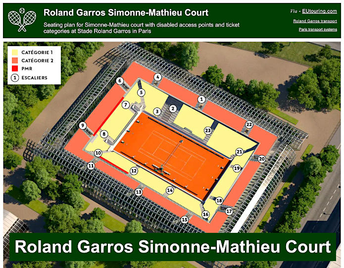
Roland Garros Simonne-Mathieu Court plan of stadium seating, disabled areas, ticket categories and access points
The latest addition to tennis courts at Roland Garros stadium is the Simonne Mathieu Court, which was constructed to replace Court 1 and was named after the womans singles champion Simonne Mathieu who also played a major part within the French Resistance during World War II, and the above court plan shows the layout of this stadium court with its seating and ticket category options along with disabled and wheelchair areas, etc.
Roland Garros Simonne-Mathieu Court plans available:
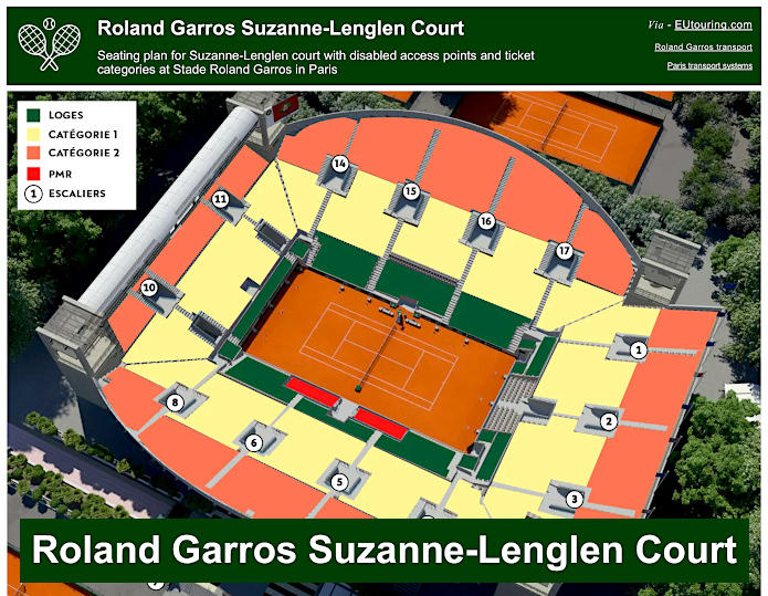
Roland Garros Suzanne-Lenglen Court plan of stadium seating, disabled areas, ticket categories and access points
Whereas here you can see the plan for the Suzanne Lenglen Court, which is the secondary stadium court that was named after the first true star of womens tennis winning 31 major tournaments including the French Open at Roland Garros 6 times, and like above, this shows the seating arrangements with the ticketing categories, access, etc.
Roland Garros Suzanne-Lenglen Court plans available: