How to get to La Grande Arche in Paris using public transport
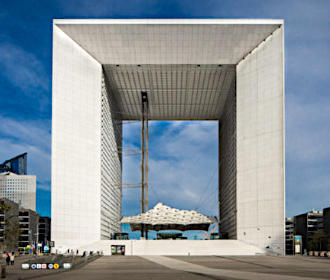
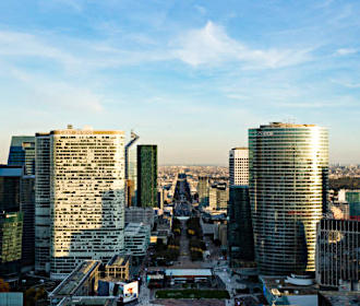
The Grande Arche monument in the Defense area has become a popular attraction, especially with its panoramic terrace, now being the largest in Paris, where you can have a view down the historical axis incorporating the Arc de Triomphe down the Champs Elysees to the Arc de Triomphe du Carrousel and The Louvre. Therefore, below you will find the different public transport options of how to get to the Grande Arche La Defense, including route maps, timetables and plans for this sometimes overlooked area on the outskirts of Paris, which can all be downloaded in PDF or image formats to your PC or mobile device.
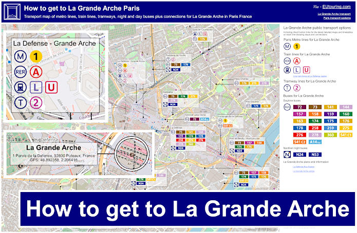
La Grande Arche transport map of Metro lines, trains, tramways, bus lines with stops, connections and street plan
Here you can see a map showing a geographical plan of the Grande Arche La Defense area, with the plaza, and of course the numerous different public transport options that are available to you, which include the Paris Metro, train lines, trams plus day buses and Noctilien night buses, either going to central Paris or to the outskirts of the Paris region, Ile de France, and all stops are no more than around 1800 metres walking distance from the Grande Arche.
As a point of interest, the Grande Arche was officially named the Grande Arche de La Fraternite when it was inaugurated in 1989 on the bicentennial of the French Revolution and located within the largest business district in Europe, it now has the largest terrace in Paris of over 1000 metres squared for incredible views that incorporates a footbridge spanning the structure, which is 100 metres in length. In addition, on the plaza beneath the Grande Arche, also referred to as the Grande Arche de La Defense, there is also an open air museum, which is the largest in France.
How to get to La Grande Arche public transport maps available:
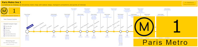
Paris Metro Line 1 stations, connections and points of interest
So here you can see the maps showing Metro Line 1 of the Paris Metro, which travels from La Defense by the Grande Arche and this is one of the ways of getting to Chateau de Vincennes via its opposite terminus point, plus it has numerous additional stops at Metro stations with transport connections for other lines including the Gare de Lyon train station that will get you to many tourist attractions in Paris and far further beyond.
Metro Line 1 stops:
La Defense, Esplanade de La Defense, Pont de Neuilly, Les Sablons, Porte Maillot, Argentine, Charles de Gaulle Etoile, George V, Franklin D Roosevelt, Champs-Elysees - Clemenceau, Concorde, Tuileries, Palais Royal - Musee du Louvre, Louvre - Rivoli, Chatelet, Hotel de Ville, Saint-Paul, Bastille, Gare de Lyon, Reuilly - Diderot, Nation, Porte de Vincennes, Saint-Mande, Berault, Chateau de Vincennes.
Metro line 1 main transport connections:
Metro Lines: 2, 4, 5, 6, 7, 8, 9, 11, 12, 13, 14. Train Lines: A, B, C, D, L, R, U. Tram Lines: T2, T3a, T3b.
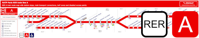
Red RER A train line map showing station stops, line branches, transport connections and zones
Whereas this map shows the Paris RER A line, which is a train line that has several branches covering stops at train stations including La Defense - Grande Arche and Marne la Vallee Chessy, which is one of the options for getting to Disneyland Paris, in addition to many others with transport connections such as Charles de Gaulle - Etoile for getting to the Arc de Triomphe, which is the famous triumphal arch on the historical axis we mentioned earlier.
Paris RER A train line stops:
Cergy le Haut*, Cergy Saint-Christophe, Cergy Prefecture, Neuville Universite, Conflans Fin d’Oise, Acheres Ville, Maisons-Laffitte, Sartrouville, Houilles - Carrieres sur Seine, Nanterre Prefecture, La Defense (Grande Arche), Charles de Gaulle Etoile, Auber, Chatelet Les Halles, Paris Gare de Lyon, Nation, Vincennes, Val de Fontenay, Neuilly Plaisance, Bry sur Marne, Noisy le Grand - Mont d’Est, Noisy Champs, Noisiel, Lognes, Torcy, Bussy Saint-Georges, Val d’Europe, Marne la Vallee - Chessy (Parcs Disneyland)*, Poissy*, Acheres - Grand Cormier, Saint-Germain en Laye*, Le Vesinet Le Pecq, Le Vesinet Centre, Chatou Croissy, Rueil Malmaison, Nanterre Ville, Nanterre University, Fontenay sous Bois, Nogent sur Marne, Joinville le Pont, Saint-Maur - Creteil, Le Parc de Saint-Maur, Champigny, La Varenne - Chennevieres, Sucy Bonneuil, Boissy Saint-Leger*.
* Terminus Points.
Paris RER A train line main transport connections:
Metro Lines: 1, 2, 3, 4, 6, 7, 8, 9, 11, 14. Train Lines: B, D, E, J, L, R, U, TGV. Tram Lines: T2, 13. Bus Lines: 393, RoissyBus, TVM (14).
Transilien train line L map showing station stops, line branches, transport connections and zones
The SNCF Transilien train line L begins at Paris Gare Saint-Lazare train station and branches off to various different stations and key locations for transport connections, often close to tourist attractions, just like La Defense by the Grande Arche, and Versailles - Rive Droite for getting to Chateau de Versailles, which is the famous former royal castle.
Paris train line L stops:
Paris Saint-Lazare*, Pont Cardinet, Clichy Levallois, Asnieres sur Seine, Becon les Bruyeres, Courbevoie, La Defense (Grande Arche), Puteaux, Suresnes - Mont Valerien, Le Val d'Or, St-Cloud, Sevres - Ville d'Avray, Chaville Rive Droite, Viroflay Rive Droite, Montreuil, Versailles Rive Droite*, Garches - Marnes la Coquette, Vaucresson, La Celle St-Cloud, Bougival, Louveciennes, Marly le Roi, L'Etang la Ville, St-Nom la Breteche - Foret de Marly**, Noisy le Roi*, Mareil Marly, St-Germain en Laye - Bel Air Fourqueux, St-Germain en Laye G.C.*, Les Vallees, La Garenne Colombes, Nanterre Universite, Houilles - Carrieres sur Seine, Sartrouville, Maisons Lafitte, Acheres Ville, Conflans - Fin d'Oise, Neuville Universite, Cergy - Prefecture, Cergy - St-Christophe, Cergy le Haut*.
* Terminus Points. ** Train L Transfer Point.
Paris train line L main transport connections:
Metro Lines: 1, 3, 9, 12, 13, 14. Trian Lines: A, E, J, U, TER. Tram Lines: T2, T6, T13.
Transilien train line U map showing station stops, transport connections and zones
Although as you can see from this map, the SNCF Transilien line U travels from the transport hub La Defense - Grande Arche through to La Verriere, with train station stops along the way including Suresnes - Mont Valerien, St-Cloud, Versailles Chantiers, St-Cyr and St-Quentin en Yvelines plus a few others, yet please take note of the different ticket tariff zones starting at zone three going through different areas to zone 5.
Paris train line U stops:
La Defense - Grande Arche*, Puteaux, Suresnes - Mont Valerien, St-Cloud, Sevres - Ville-d'Avray, Chaville Rive Droite, Versailles Chantiers, St-Cyr, St-Quentin en Yvelines, Trappes, La Verriere*.
* Terminus Points.
Paris train line U main transport connections:
Metro Line: 1. Train Lines: A, C, L, N, TER. Tram Line: T2.
Paris tram line T2 map with tramway stations, transport connections and zones
This next map with its timetables shows the Paris tram line T2 that travels between Pont de Bezons and Porte de Versailles, which is an option of getting to Dome de Paris and the exhibition centre, yet travelling through many communes, or areas, of the Paris region on route with tramway stops that have numerous transport connections like La Defense - Grande Arche, this tramway line is also an option for getting to the Hippodrome de Longchamp, Parc de St-Cloud, Musee de Sevres, and many others.
Paris tram line T2 stops:
Pont de Bezons, Parc Pierre - Lagravere, Victor Basch, Jacqueline Auriol, Charlebourg, Les Fauvelles, Faubourg de l'Arche, La Defense (Grande Arche), Puteaux, Belvedere, Suresnes - Longchamp, Les Coteaux, Les Milons, Parc de St-Cloud, Musee de Sevres, Brimborion, Meudon-sur-Seine, Les Moulineaux, Jacques-Henri Lartigue, Issy - Val de Seine, Henri Farman (Porte de Seine), Suzanne Lenglen, Porte d’Issy, Porte de Versailles (Parc des Expositions).
Paris tram line T2 main transport connections:
Metro Lines: 1, 8, 9, 10, 12. Train Lines: A, C, L, U. Tram Line: T3a.
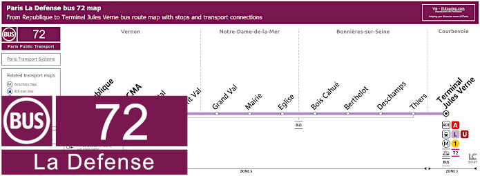
Paris La Defense bus 72 map Republique to Terminal Jules Verne with stops and connections
You will find numerous different buses that travel to the Grande Arche within La Defense area of Paris, just like bus line 72, which travels from La Defense Terminal Jules Verne through to Republique Vernon.
Paris La Defense bus line 72 stops:
Republique, SNECMA, Hopital, Petit Val, Grand Val, Mairie, Eglise, Bois Chue, Berthelot, Deschamps, Thiers, Terminal Jules Verne.
Paris La Defense bus line 72 main transport connections:
Metro Line: 1. Train Lines: A, L, U. Tram line: T2
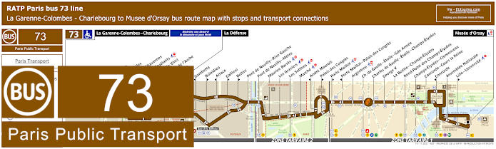
RATP Paris bus line 73 with stops, connections and street plan
Whereas here you have the Paris bus route for the RATP bus line 73 that travels between La Garenne-Colombes - Charlebourg, La Defense and Musee d'Orsay, although we would like to point out that the service starts at La Defense by the Grande Arche on a Sunday and French holidays, meaning the bus stops prior like Faubourg de l'Arche, are not served on those days, yet this bus route is also an option for getting to the Palais des Congres event centre.
Paris bus line 73 stops:
La Garenne-Colombes - Charlebourg***, Nordmann***, Les Fauvelles***, Puvis de Chavannes***, Rue des Etudiants***, Leonardo de Vinci***, Faubourg de l’Arche** ***, Caron***, La Defense, Gambetta*, Boieldieu**, Alsace*, Gallieni**, Bellini**, Pont de Neuilly - Rive Gauche, Pont de Neuilly, Les Graviers, Rue de l’Hotel de Ville, Les Sablons, Marche, Montrosier*, Andre Maurois**, Palais des Congres**, Porte Maillot**, Porte Maillot - Palais des Congres*, Argentine, Charles de Gaulle - Etoile - Gde Armee, Charles de Gaulle - Etoile - Champs-Elysees, George V, La Boetie - Champs-Elysees, Rond-Point des Champs-Elysees, Champs-Elysees - Clemenceau, Concorde - Cours la Reine, Concorde*, Assemblee Nationale, Lille - Universite**, Musee d'Orsay.
* Stop served in direction of La Garenne-Colombes - Charlebourg or La Defense. ** Stop served in direction of Musee d'Orsay. *** Not served on a Sunday or French holidays.
Paris bus line 73 main transport connections:
Metro Lines: 1, 2, 6, 8, 9, 12, 13. Train Lines: A, C, L, U. Tram Line: T2.
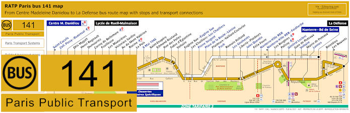
RATP Paris bus line 141 with stops, connections and street plan
Although, the RATP Paris bus line 141 has different routes depending upon the hours as you will see from the 141 bus maps and timetables, with a bus route shown in white and bus stops highlighted in blue, yet the main bus route travels from Lycee de Rueil-Malmaison to La Defense and includes stops like Gare de Puteaux for additional transport connections. So if you are thinking of utilising the 141 bus line for getting to the Grande Arche, then please make sure you only utilise the main line to La Defense, as the other part of the route for set times will only get you around 4000 metres away, which is almost 3 miles!
Paris bus line 141 stops:
Centre Madeleine Danielou, Saint-Cucufa**, Coll. Passy - Buzenval, Lycee de Rueil-Malmaison, Otis Mygatt, Henri Regnault, Dumouriez, Carrey de Bellemare, Fouilleuse, Les Mazurieres, Victorien Sardou, Avenue du Mont Valerien, Racine, La Paix, 8 Mai 1945, Saint-Exupery, Edmond Rostand, Rue des Folies, Fabre d'Egiantine, Voltaire, Eugene Sue - Eugene Sue, Les Chailliers - Les Chailliers, Pierre Sergent, Place de la Boule-Lenine, Plaideurs - Vaillant-Couturier, Foch, Romain Rolland, Les Goulvents, Liberte - Plaideurs, Jules Quentin, Felix Faure, Nanterre-Ville RER, Nanterre-Ville RER - Faidherbe*, Les Bergeres, Palissy, General Leclerc, Gare de Puteaux, Voltaire, Mairie de Puteaux, Lannes, Nanterre - Bd de Seine, Boieldieu, Les Bouvets**, La Defense.
* Served in direction of Centre Madeleine Danielou. ** Served in direction of La Defense.
Bus 141 stops served at specific hours, but not during school holidays:
Centre Madeleine Danielou, Saint-Cucufa, Passy - Buzenval, Place du 8 Mai 1945, Eugene Sue, Les Chailliers, Pierre Sergent, Place de la Boule, Foch, Les Goulvents, Jules Quentin, Nanterre-Ville RER, General Leclerc, Voltaire, Lannes, Nanterre - Boulevard de Seine.
Paris bus line 141 main transport connections:
Metro Line: 1. Train Lines: A, L, U. Tram Line: T2. Bus Lines: 45, 73, 144, 157, 158, 159, 160, 174, 178, 258, 275, 276, 278, 360, 367, 378, 467, 559d, Buseolien (541), Express A14, Ligne Bleue (559).
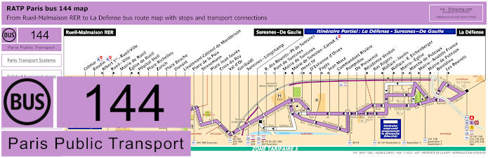
RATP Paris bus line 144 with stops, connections and street plan
The Paris bus route for the RATP line 144 travels between Rueil-Malmaison RER, Suresnes - De Gaulle and La Defense, but again, please take note of the 144 bus maps and timetables, as it shows that bus stops between La Defense and Charles de Gaulle are only a partial service, in addition to the fact that there are two bus stops at La Defense by the Grande Arche, depending upon what terminus point you are travelling to, not forgetting stops like Les Bouvets are only served in one direction.
Paris bus line 144 stops:
Rueil-Malmaison RER, Colmar, Baudin, Albert 1er - Rueil-Ville*, Rueil - Ville**, Mairie de Rueil, Eglise de Rueil**, Hopital Stell*, Place Richelieu, Zurich, Place Besche, Dunant, Lieutenant-Colonel de Montbrison, Place de la Paix, Stresemann, Place Jean Jaures, Croix du Roy, Val d'Or, Garibaldi, Suresnes - Longchamp, Suresnes - De Gaulle, R. des Bourets - Pont de Suresnes***, Pont de Suresnes***, Mairie de Suresnes**, Mairie de Suresnes - Carnot*, Henri IV** ***, D'Estienne d'Orves*, Pages**, Jean Mace*, Commandant Riviere**, Pompidou, De Pressense, Residence Verdun**, Bas Rogers, Wallace - Jaures*, Wallace - E. Eichenberger**, Marche de Puteaux*, Mairie - Eglise**, Mairie - Anatole France*, Mairie de Puteaux**, Boieldieu, Les Bouvets**, La Defense.
* Served in the direction of Rueil-Malmaison RER. ** Served in direction of La Defense. *** Only served at specific hours in Rueil-Malmaison RER direction.
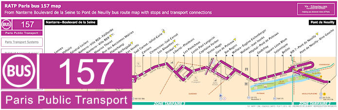
RATP Paris bus line 157 with stops, connections and street plan
Yet the RATP bus line 157 travels between Nanterre - Boulevard de la Seine and Pont de Neuilly, and as you can see from the bus maps and timetables, there are several stops on route that are only served in a particular direction, but for getting to the Grande Arche you would need the Pont de Neuilly - Rive Gauche bus stop, which is approximately 1600 metres walk from this famous Paris monument.
Paris bus line 157 stops:
Nanterre - Boulevard de la Seine, Lannes, Voltaire, General Leclerc, Nanterre - Ville RER - Faidherbe, Nanterre - Ville RER, Maurice Thorez, Rue des Anciennes Mairies, Plainchamp, Rochegude, Les Venets, Sadi Carnot - Joliot-Curie, Carriers, Clemenceau - Sadi Carnot, Les Alouettes, Verdun, Liberte - Plaideurs, Les Parechaux, Lycee Paul Langevin, Capitaine Ferber, Victor Hugo, Gare de Puteaux, Bas Rogers, Wallace - Eugene Eichenberger, Wallace - Jean Jaures, Hopital - Pont de Puteaux, Godefroy, Square Leon Blum, Soljenitsyne, Bellini, RD7 - Pont de Neuilly, Pont de Neuilly - Rive Gauche, Pont de Neuilly.
Paris bus line 157 main transport connections:
Metro Line: 1. Train Line: A. Tram Line: T2. Bus Lines: 43, 73, 93, 158, 159, 160, 163, 174, 175, 176, 304, 367, 378, Buseolien 1 (541), Ligne Bleue (559).
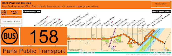
RATP Paris bus line 158 with stops, connections and street plan
However, here you have the maps and timetables for RATP bus line 158 that travels between Rueil-Malmaison RER and Pont de Neuilly, and just like above, it is the Pont de Neuilly - Rive Gauche bus stop that you would need in order to get to the Grande Arche de La Defense on the outskirts of Paris.
Paris bus line 158 stops:
Rueil-Malmaison RER, D'Estienne d'Orves, Pereire*, Cite du Vieux Pont*, Rue du Mans, Les Goulvents, Foch, Place de la Boule - Lenine, Place de la Boule - Clemenceau, La Source, Clemenceau - Sadi Carnot, Felix Faure, Les Fontenelles, Craiova, Les Bergeres - Marche**, Palissy**, Gare de Puteaux, Mairie de Puteaux, Rousselle, Paul Lafargue, Arago - Jean Jaures**, Soljenitsyne, Bellini*, RD7 - Pont de Neuilly*, Pont de Neuilly - Rive Gauche, Pont de Neuilly.
* Served in direction of Rueil-Malmaison RER. ** Served in direction of Pont de Neuilly.
Paris bus line 158 main transport connections:
Metro Line: 1. Train Lines: A, L, U. Tram Line: T2. Bus Lines: 4E, 27, 43, 73, 93, 141, 144, 157, 160, 174, 176, 241, 244, 258, 259, 304, 360, 367, 476, 559a, 559b, 563, Buseolien 1 (541), Buseolien 2 (541), Ligne Bleue (559).
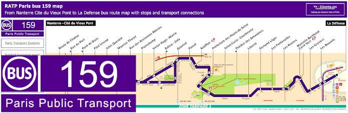
RATP Paris bus line 159 with stops, connections and street plan
This shows the RATP Paris bus line 159 that has a route travelling between Nanterre - Cite du Vieux Pont and La Defense by the Grande Arche, and with over 20 additional bus stops as you can see from the maps and timetables, they are all in ticket tariff zone 3 in different communes or areas and some go by Parc Andre Malraux, but like Theatre des Amandiers, so bus stops are only served in a specific direction.
Paris bus line 159 stops:
Nanterre - Cite du Vieux Pont, Route de Chatou, Rue du Port*, Pont de Biais*, Paul Lescop, Jules Quentin, Maurice Thorez, Rue des Anciennes Mairies, Plainchamp, Victor Hugo - Mairie, Balzac - Zola**, Gounod, Pascal, Soufflot, Prefecture des Hauts-de-Seine, Joliot-Curie - Courbevoie, Theatre des Amandiers*, Liberte, Fernand Leger, Les Fontenelles, Les Rosiers, Marcelin Berthelot - Carre Vert, Les Graviers, Les Bouvets, La Defense.
* Stop served in direction of Nanterre - Cite du Vieux Pont. ** Stop served in direction of La Defense.
Paris bus line 159 main transport connections:
Metro Line: 1. Train Lines: A, L, U. Tram Line: T2. Bus Lines: 73, 141, 144, 157, 158, 160, 174, 178, 258, 259, 275, 276, 278, 304, 360, 367, 378, Ligne Bleue (559).
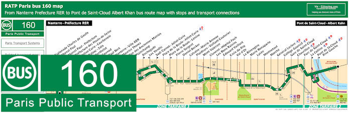
RATP Paris bus line 160 with stops, connections and route plan
Additionally, you have the Paris bus line 160 that goes from Nanterre - Prefecture RER, which is actually the terminus stop you would need for getting to the Grande Arche at a distance of around 1200 metres walk away, and this bus route goes through to Pont de Saint-Cloud - Albert Kahn close to the Parc de Saint-Cloud that is another one of the popular Paris tourist attractions.
Paris bus line 160 stops:
Nanterre - Prefecture RER, Esplanade Charles de Gaulle*, Marcel Paul**, Marcel Paul - Prefecture*, Prefecture des Hauts-de-Seine**, Joliot-Curie - Courbevoie, Balzac - Zola, Berthelot*, Gounod, Paul Bert, Nanterre-Ville RER, Maurice Thorez**, Rue des Anciennes Mairies, Plainchamp, Rochegude**, Les Venets*, Sadi Carnot - Joliot-Curie**, Place de la Boule - Joliot-Curie, Place de la Boule - Lenine**, Pierre Sergent, Daniel Becker, Calvaire - Mairie Annexe, Plaideurs - Vaillant-Couturier, Mont Valerien, Cluseret - Hopital Foch, Les Bons Raisins, Edouard Vaillant, Croix du Roy, Val d'Or, La Berengere, Marie Bonaparte, Lycee, Montretout, Marche, General Leclerc, College Gounod, Gare de Saint-Cloud, Chevrillon, Parc de Saint-Cloud, La Colline**, Pont de Saint-Cloud - Rive Gauche**, Pont de Saint-Cloud - Albert Khan.
* Served in direction of Nanterre - Prefecture RER. ** Served in direction of Pont de Saint-Cloud - Albert Khan.
Paris bus line 160 main transport connections:
Metro line: 10. Train lines: A, L, U. Tram line: T2. Bus lines: 17, 52, 72, 126, 157, 158, 159, 163, 175, 241, 258, 259, 276, 304, 360, 367, 378, 459, 460, 467, 471, 559d, 559 a-b, 563, AS (544), Ligne Bleue, Ligne Rouge.
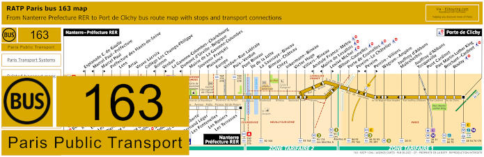
RATP Paris bus line 163 with stops, connections and street plan
When it comes to getting to the Grande Arche of La Defense via the RATP bus line 163, you will find that you would need the terminus point of Nanterre - Prefecture RER, yet during certain hours there is a bus stop even closer called Les Terrasses, as you can see from the bus maps and timetables on the white line that goes to Centre Madeleine Danielou, although the standard route travels from Nanterre - Prefecture RER to Port de Clichy.
Paris bus line 163 stops:
Nanterre - Prefecture RER, Esplanade Charles de Gaulle*, Marcel Paul - Prefecture*, Marcel Paul**, Prefecture des Hauts-de-Seine, Lens, Arras, Veuve Lacroix, College Les Champs-Philippe , Bonnin*, Verdun**, La Garenne-Colombes - Charlebourg, Dumont d'Urville - Belgique*, Mairie de La Garenne - Colombes, Souvenir Francais, Plaisance, Europe, Verdun - Rue Laterale, Paix - Verdun, Pont Bineau, Ile de la Jatte, La Saussaye - Bineau, Bineau - Chateau, Chezy, Inkermann - Bineau, Victor Hugo, Villiers - Bineau, Anatole France - Metro*, Mairie de Levallois*, Louise Michel**, Wilson - Courcelles, Pereire - Le Chatelier**, Pereire*, Pereire - Villiers**, Wagram - Ampere, Jouffroy d'Abbans - Malesherbes, Jouffroy d'Abbans - Tocqueville, Pont Cardinet, Parc Martin Luther King, Brochant - Cardinet, Boulay, Port de Clichy.
* Stop served in direction of Nanterre - Prefecture RER. ** Stop served in direction of Port de Clichy.
Bus 163 stops served at specific hours:
Centre Madeleine Danielou, College Passy - Buzenval, 8 mai 1945, Eugene Sue, Les Chailliers, Pierre Sergent, Place de la Boule - Lenine, Place de la Boule - Joliot-Curie, Sadi-Carnot - Joliot-Curie, Palais des Sports, Liberte, Fernand Leger, Les Fontenelles, Les Rosiers, Les Terrasses, Nanterre - Prefecture RER.
Paris bus line 163 main transport connections:
Metro lines: 3, 13, 14. Train lines: A, C, L. Tram lines: T2, T3b. Bus lines: 20, 28, 31, 54, 63, 66, 73, 74, 82, 84, 92, 93, 94, 160, 164, 165, 173, 174, 176, 178, 259, 275, 276, 278, 341, Les Abeilles A, PC (98).
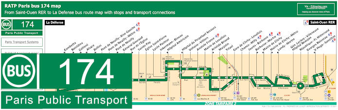
RATP Paris bus line 174 with stops, connections and street plan
So here you can see the RATP Paris bus line 174 which travels between Saint-Ouen RER, Trezel and La Defense - Grande Arche, although as you can see from the maps and timetables, there are certain bus stops only served in the evening with a final departure from La Defense by the Grande Arche monument at 10:30pm and Trezel at 10:15pm in addition to some stops only being served in certain directions.
Paris bus line 174 stops:
La Defense, Gambetta*, Boieldieu**, Gallieni**, Alsace*, Bellini**, Pont de Neuilly - Rive Gauche, Pont de Neuilly - Metro, Pont de Neuilly**, General Gouraud, Rue de l'Eglise**, Sainte-Foy, Eglise Saint-Pierre, Lycee Pasteur, Inkermann - Bineau, Hopital Americain*, Place de la Liberation*, Hopital du Perpetuel Secours*, Voltaire - Villiers, Anatole France, Mairie de Levallois, Aristide Briand**, Marjolin, Trezel, Jean Jaures - Victor Hugo, Collange, Rue Petit, Fournier, Rue du Port, Leon Blum**, Danielle Casanova**, Mairie de Clichy**, Gabriel Peri*, Mairie de Clichy - Metro**, Landy - Martre*, Gen. Leclerc - Villeneuve - Hopital Beaujon, Republique - Fr. Mitterrand, Georges Boisseau, Victor Hugo - Sanzillon*, Saint-Ouen RER.
* Stop served in direction of La Defense. ** Stop served in direction of Saint-Ouen RER.
Paris bus line 174 main transport connections:
Metro Lines: 1, 3, 13. Train Lines: A, C. Tram Line: T2. Bus Lines: 43, 54, 73, 93, 139, 141, 144, 157, 158, 159, 173, 176, 178, 258, 274, 275, 276, 278, 340, 341, 360, TUC (574).
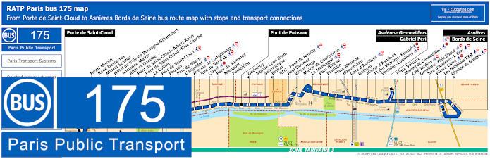
RATP Paris bus line 175 with stops, connections and street plan
However, here we have the bus maps and timetables for bus line 175 that travels between Porte de Saint-Cloud and Asnieres - Bords de Seine, with two other key stops in between, being Pont de Puteaux and Asnieres - Gennevilliers - Gabriel Peri. But for getting to the Grande Arche you would need the Soljenitsyne bus stop at approximately 1600 metres or just over a mile walk away, although the Paul Doumer stop is possible at around 2000 metres, whereas the Bellini stop in nearer yet only travels in the direction of Pont de Puteuax and Porte de Saint-Cloud.
Paris bus line 175 stops:
Porte de Saint-Cloud, Henri Martin, Rene Descartes, Marcel Sembat, Hotel de Ville de Boulogne-Billancourt, Ancienne Mairie, Rhin et Danube, Pont de Saint-Cloud - Albert Kahn, Pont de Saint-Cloud - Rive Gauche*, La Colline*, Parc de Saint-Cloud, Feudon, Parc de Bearn, L’ Aqueduc, Avenue de Longchamp, Rue du Val d’Or, Clavel, Pont de Suresnes, Nieuport, Pompidou, Pont de Puteaux, Godefroy*, Square Leon Blum, Soljenitsyne, Bellini*, RD7 - Pont de Neuilly, Paul Doumer, Victor Hugo, Mairie de Courbevoie, La Montagne, Pont Bineau, Franklin, Place Mermoz, Haussmann, Gare d’Asnieres, Gallieni, Mairie d’Asnieres, Place des Victoires - Marche, Voltaire - Lumieres, Asniers - Gennevilliers - Gabriel Peri, Place Voltaire, Marche de Gennevilliers, Cite Jardins, Gresillons - Felix Eboue, Tour d'Asnieres - L. Cely, Pierre Curie, Les Gresillons RER, Olympe de Gouges*, Asnieres - Bords de Seine.
* Only served in the direction of Porte de Saint-Cloud.
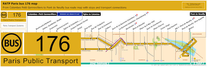
RATP Paris bus line 176 with stops, connections and street plan
The Paris bus line 176 travels from Pont de Neuilly to Colombes - Petit Gennevilliers, although we would like to point out that as you can see from the bus maps and timetables, of an evening the route terminates at Eglise de Colombes, yet for getting to the Grande Arche de La Defense you would need the Pont de Neuilly - Rive Gauche bus stop.
Paris bus line 176 stops:
Colombes - Petit Gennevilliers, Boulevard d'Acheres, Valmy - Gambetta - Stade, Fraternite, General Leclerc*, Eglise de Colombes, Eglise de Colombes, Jacques Eleonor Ferme, Ostyn, Gros Gres**, Rue de l'Industrie*, Rue du Commerce, Colbert**, Gare de La Garenne-Colombes, La Garenne-Colombes - Charlebourg, Nordmann, Rhin et Danube, Place du 8 Mai 1945, Gare de Courbevoie, Place Charras, Victor Hugo, Paul Doumer, RD 7 - Pont de Neuilly**, Pont de Neuilly - Rive Gauche, Bellini**, Pont de Neuilly.
* Stop served in direction of Colombes - Petit Gennevilliers. ** Stop served in direction of Pont de Neuilly.
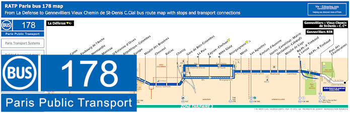
RATP Paris bus line 178 with stops, connections and street plan
So as you can see from the RATP Paris bus line 178, this goes from La Defense by the Parvis very close to the Grande Arche with the terminus often called La Defense - Grande Arche and travelling through various communes of the Paris region to Gennevilliers RER, there are also two additional bus stops of Parc des Chanteraines and Gennevilliers - Vieux Chemin de St-Denis - Centre Commercial, which are served on weekends and holidays, as you can see from the bus maps and timetables.
Paris bus line 178 stops:
La Defense, Caron, Faubourg de l’Arche, Normandie, Marceau, D’Estienne d’Orves, Republique - Colombes, Moulin des Bruyeres, Chevreul, Balzac, Chanzy, Gare de Bois - Colombes, La Paix, Cayron - Chefson, Abbe Glatz, Bourguignons, Menil, Les Agnettes, Couture d’Auxerre, Jaures - Camelinat - Mairie, Deslandes - Caboeufs, Moulin de Cage, Rd-Pt - P. Timbaud - J. Larose, Rond-Point - P. Timbaud, Gennevilliers RER, Parc des Chanteraines, Gennevilliers - Vieux Chemin de St-Denis - C.Cial.
Paris bus line 178 main transport connections:
Metro Lines: 1, 13. Train Lines: A, C, J, L, U. Tram Lines: T1, T2. Bus Lines: 45, 73, 138, 140, 141, 144, 159, 163, 164, 165, 166, 167, 174, 238, 258, 275, 276, 278, 340, 360, 366, Express A-14, Le Bus du Port (538), River Plaza (577).
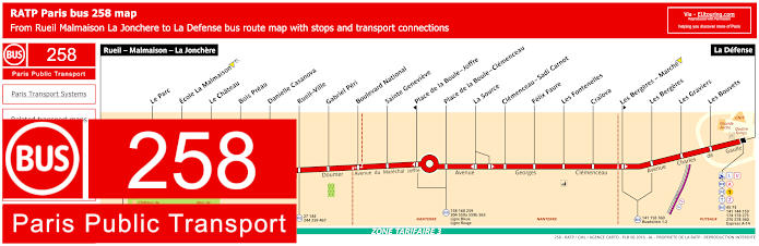
RATP Paris bus line 258 with stops, connections and street plan
Whereas the Paris Bus route for the RATP line 258 travels between Rueil - Malmaison - La Jonchere to La Defense, also sometimes referred to as La Defense - Grande Arche, due to its location within only a few metres walk from the famous modern monument of the Grande Arche, and with bus stops on route that have transport connections to other bus lines such as Rueil-Ville, Place de la Boule - Clemenceau, would like to point out that as you can see from the maps and timetables, there are 2 stops only served in specific directions.
Paris bus line 258 stops:
Rueil - Malmaison - La Jonchere, Le Parc, Ecole La Malmaison, Le Chateau, Bois Preau, Danielle Casanova, Rueil - Ville, Gabriel Peri, Boulevard National, Sainte Genevieve, Place de la Boule - Joffre*, Place de la Boule - Clemenceau, La Source, Clemenceau - Sadi Carnot, Felix Faure, Les Fontenelles, Craiova, Les Bergeres - Marche**, Les Bergeres, Les Graviers, Les Bouvets, La Defense.
* Stop served in direction of Rueil - Malmaison - La Jonchere. ** Stop served in direction of La Defense.
Paris bus line 258 main transport connections:
Metro line: 1. Train lines: A, L, U. Tram line: T2. Bus lines: 27, 45, 73, 141, 144, 158, 159, 160, 174, 178, 244, 259, 275, 276, 278, 304, 360, 467, 559a, 559b, 563, Buseolien 1 & 2 (541), Express A14, Ligne Bleue (559), Ligne Rouge.
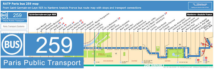
RATP Paris bus line 259 with stops, connections and street plan
Here we have the maps and timetables for the RATP bus line 259 that travels from Saint-Germain-en-Laye RER to Nanterre - Anatole France and with numerous bus stops on route, yet some of them only accessible for a certain direction of travel like Theatre des Amandiers, but for getting to the Grande Arche you would need the Nanterre - Prefercture RER bus stop.
Paris bus line 259 stops:
Saint-Germain-en-Laye RER, Place Royale, Giraud-Teulon*, Alexandre Bertrand***, L'Ermitage***, Val Andre***, Jaures***, Bas Prunay***, Pavillon Halevy***, La Machine***, La Passerelle, Pont de Bougival, La Chaussee - Musee Tourgueniev, Maison Rouge, La Jonchere, Le Parc, Ecole La Malmaison***, Le Chateau, Bois Preau, Danielle Casanova, Rueil - Ville, Gabriel Peri, Boulevard National, Sainte-Genevieve, Place de la Boule - Joffre*, Place de la Boule - Joliot-Curie, Sadi Carnot - Joliot-Curie, Carriers, Le Chat Perche, Les Champs Pierreux, Liberte, Theatre des Amandiers**, Joliot-Curie - Courbevoie, Pref. des Hauts-de-Seine*, Marcel Paul - Prefecture**, Marcel Paul*, Esplanade C. de Gaulle, Nanterre - Pref. RER, 17 Octobre 1961, Nanterre - Univ. RER, Nanterre - Anatole France.
* Stop served in the direction of Saint-Germain-en-Laye RER. ** Stop served in the direction of Nanterre - Anatole France. *** Stop not accessible to those with reduced mobility.
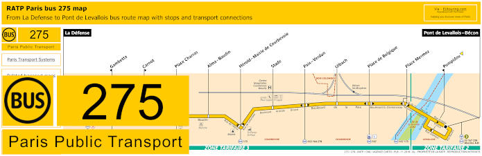
RATP Paris bus line 275 with stops, connections and street plan
But this map and its timetables shows the Paris Bus route for the RATP bus line 275 travelling from La Defense right by the Grande Arche through to Pont de Levallois - Becon, although please take note that there are 3 bus stops being Gambetta, Carnot and Pompidou, which are only served in a specific direction.
Paris bus line 275 stops:
La Defense, Gambetta*, Carnot**, Place Charras, Alma - Baudin, Herold - Mairie de Courbevoie, Stade, Paix - Verdun, Ulbach, Place de Belgique, Place Mermoz, Pompidou*, Pont de Levallois.
* Stop served in direction of La Defense. ** Stop served in direction of Pont de Levallois.
Paris bus line 275 main transport connections:
Metro lines: 1, 3. Train lines: A, L, U. Tram line: T2. Bus lines: 45, 53, 73, 141, 144, 159, 163, 164, 167, 174, 175, 176, 178, 238, 258, 276, 278, 360, Abeilles A-B, Express A14.
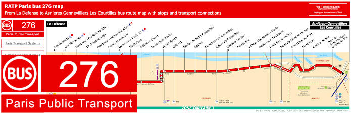
RATP Paris bus line 276 with stops, connections and street plan
However, here is another RATP Paris bus map with its timetables for the bus line 276 that goes from La Defense right by the Grande Arche through to Asnieres - Gennevilliers - Les Courtilles with different bus stops on route that have transport connections to trains, trams, etc including Nanterre - Prefecture RER, Victor Basch, Eglise de Colombes and others.
Paris bus line 276 stops:
La Defense, Les Bouvets* ***, Les Terrasses* ***, Nanterre - Prefecture RER, 17 Octobre 1961, Nanterre - Universite RER***, Francois Hanriot, Universite Paris 10* ***, Noel Pons, Defense Ouest, Jacqueline Auriol, Victor Basch, Colbert, Ecoles du Petit Colombes, Egalite, Cimetiere de Colombes, Eglise de Colombes, General Leclerc**, Fraternite, Valmy - Gambetta - Stade, Boulevard d'Acheres, Petit Gennevilliers, Pont du Chemin de Fer, Direction du Port, Mercieres, Centre de Vie, Porte de Gennevilliers - Centre de Vie, Asnieres - Gennevilliers - Les Courtilles.
* Stop served in direction of La Defense. ** Stop served in direction of Asnieres - Gennevilliers - Les Courtilles. *** Not accessible to those with reduced mobility.
Paris bus line 276 main transport connections:
Metro lines: 1, 13. Train lines: A, L, U. Tram lines: T1, T2. Bus lines: 45, 73, 140, 141, 144, 159, 160, 163, 164, 167, 174, 176, 178, 235, 238, 258, 259, 275, 278, 304, 340, 360, 366, 367, 378, 566, Bus du Port (538), Express A14.
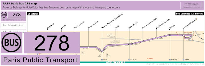
RATP Paris bus line 278 with stops, connections and street plan
Again going from the transport hub of La Defense by the Grande Arche Paris monument through to Bois-Colombes - Les Bruyeres, the Paris bus route 278 run by RATP has 11 additional bus stops such as Place Charras, Stade, etc, although as you can see from the maps and timetables, certain stops like Gambetta and Europe are only served in the direction of La Defense - Grande Arche.
Paris bus line 278 stops:
La Defense, Gambetta*, Carnot**, Place Charras, Alma - Baudin, Herold - Mairie de Courbevoie, Stade, Paix - Verdun, Verdun - Rue Laterale, Courbevoie - Europe, Europe*, Moulin des Bruyeres, Bois-Colombes - Les Bruyeres.
* Stop served in direction of La Defense. ** Stop served in direction of Bois-Colombes - Les Bruyeres.
Paris bus line 278 main transport connections:
Metro line: 1. Train lines: A, L, U. Tram line: T2. Bus lines: 45, 73, 141, 144, 159, 163, 164, 167, 174, 175, 176, 178, 258, 275, 276, 360, Express A14.
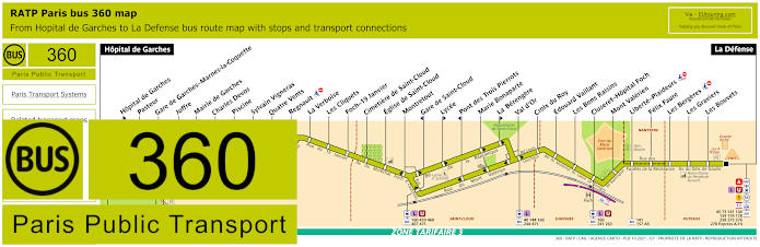
RATP Paris bus line 360 with stops, connections and street plan
Additionally, these timetables and maps show the Paris Bus route for the RATP line 360 that travels between Hopital de Garches and La Defense transport hub by the Grande Arche, with several bus stops on route and some with transport connections like Gare de Garches - Marnes-la-Coquette, Gare de Saint-Cloud, Val d'Or and Cluseret - Hopital Foch, Mont Valerien, plus many more, but please take note of some stops only being served in a particular direction.
Paris bus line 360 stops:
Hopital de Garches, Hopital de Garches**, Pasteur, Gare de Garches - Marnes-la-Coquette, Joffre, Mairie de Garches, Charles Devos, Piscine, Sylvain Vigneras, Quatre Vents, Regnault, La Verboise, Les Cliquets, Foch - 19 Janvier, Cimetiere de Saint-Cloud, Eglise de Saint-Cloud, Montretout, Gare de Saint-Cloud*, Lycee**, Pont des Trois Pierrots*, Marie Bonaparte, La Berengere**, Val d'Or, Croix du Roy, Edouard Vaillant, Les Bons Raisins, Cluseret - Hopital Foch, Mont Valerien, Liberte - Plaideurs, Felix Faure, Les Bergeres, Les Graviers, Les Bouvets, La Defense.
* Stop served in direction of Hopital de Garches. ** Stop served in direction of La Defense.
Paris bus line 360 main transport connections:
Metro line: 1. Train line: A, L, U. Tram line: T2. Bus lines: 9, 37, 40, 45, 73, 141, 144, 157, 159, 160, 174, 178, 241, 244, 258, 263, 275, 276, 278, 426, 459, 460, 467, 471, AS (544), Express A14.
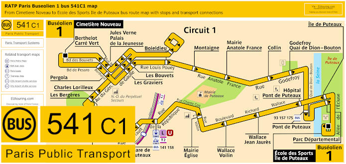
Paris Buseolien 1 bus line 541C1 with stops, connections and street plan
Now this shows the bus line 541 Circuit 1, also known as Buseoleon Circuit 1, which operates a route in a complete loop starting at Cimetiere Nouveau, but with a return point of Ecole des Sports - Ile de Puteaux, and as you can see from the bus maps and timetables, you would need either the Jules Verne - Palais de la Jeunesse stop or the Les Bouvets bus stop, either of which will get you within easy walking distance of the Grande Arche within the La Defense area, which is the business district on the outskirts of Paris.
Paris Bus Line 541C1 stops direction Ile de Puteaux:
Cimetiere Nouveau, Berthelot - Carre Vert, Pergola, Les Graviers, Les Bouvets, Boieldieu, Montaigne, Mairie Anatole France, Collin, Godefroy - Quai de Dian Bouton, Pont de Puteaux, Parc Departmental, Ecole des Sports Ile de Puteaux.
Paris Bus Line 541C1 stops direction Cimetiere Nouveau:
Ecole des Sports Ile de Puteaux, Ile de Puteaux, Hopital Pont de Puteaux, Wallace - Jean Jaures, Wallace - Voilin, Mairie - Eglise, Gare du Puteaux, Offenbach, Cartault - Palissy, Gutenberg, Palissy, Charles Lorilleux, Les Graviers, Les Bouvets, Les Bouvets, Les Graviers, Jules Verne - Palais de la Jeunesse, Berthelot - Carre Vert, Cimetiere Nouveau.
Paris Bus Line 541C1 main transport connections:
Train Lines: L, U. Tram Line: T2. Bus Lines: 93, 141, 144, 157, 158, 159, 175, 258, 360, Buseolien 2.
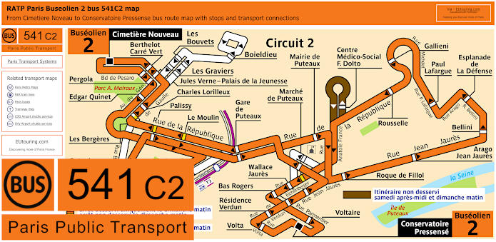
Paris Buseolien 2 bus line 541C2 with stops, connections and street plan
Whereas here we have the bus line 541 Circuit 2, also referred to as Buseoleon Circuit 2, which is the orange line also travelling in a loop from Cimetiere Nouveau but with a return point of Conservatoire Pressense, yet as you can see from these bus maps and timetables, there is a slightly different route on a Sunday with certain stops not served on that day and another not served on a Saturday after midday or Sunday morning. So for getting to the Grande Arche on a Sunday you could utilise the Les Bouvets stop, otherwise it would be the Jules Verne - Palais de la Jeunesse stop or the Esplanade de la Defense bus stop, which is also slightly nearer.
Paris bus line 541C2 stops direction Puteaux Conservatoire-Pressense:
Cimetiere Nouveau, Edgar Quinet, Les Bergeres, Offenbach, Cartault - Palissy, Gutenberg, Gare de Puteaux, Mairie de Puteaux, Roque de Fillol, Arago - Jean Jaures, Belini, Espl. de la Defense Metro, Paul Lafargue, Gallieni, Rousselle, CMS Francoise Dolto, Marche de Puteaux, Wallace - Jaures, Bas Rogers, Voltaire, Conservatoire Pressense.
Paris bus line 541C2 stops direction Puteaux Cimetiere Nouveau:
Conservatoire Pressense, Volta, Residence Verdun, Bas Rogers, Wallace - Jaures, Marche de Puteaux, Gare de Puteaux, Le Moulin, Palissy, Charles Lorilleux, Jules Verne, Berthelot - Carre Vert, Cimetiere Nouveau.
Paris bus line 541C2 main transport connections:
Train Lines: L, U. Tram Line: T2. Bus Lines: 141, 158, Buseolien 1.
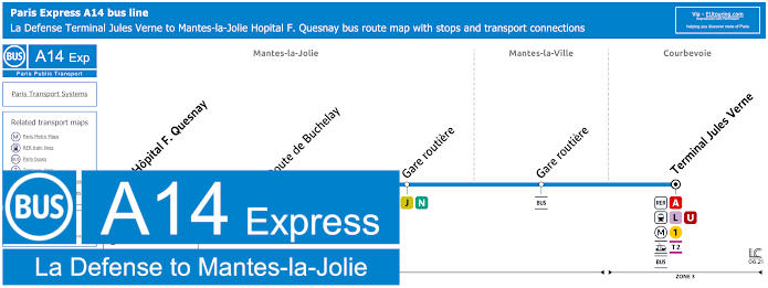
Paris bus Express A14 line La Defense to Mantes-la-Jolie with stops and transport connections
Yet the Bus Express A14, often referred to as the A14 Mantes-la-Jolie-La Defense Express line runs from La Defense - Terminal Jules Verne to Mantes-la-Jolie - Hopital with 3 additional bus stops on route, which runs daily, although as you will see from the timetables, please note the different times depending upon your day of travel in addition to certain times highlighted in blue where it does not operate between 3rd August and 14th August.
Paris bus Express A14 line Mantes-la-Jolie stops:
Mantes-la-Jolie - Hopital F. Quesnay, Route de Buchelay, Gare Routiere SNCF, Mantes-la-Ville - Gare Routiere, La Defence - Terminal Jules Verne.
Paris bus Express A14 line Mantes-la-Jolie main transport connections:
Metro line: 1. Train lines: A, J, L, N, U. Tram line: T2. Bus line: 45.
Paris bus Express A14 La Defense to Mantes-la-Jolie route maps available:
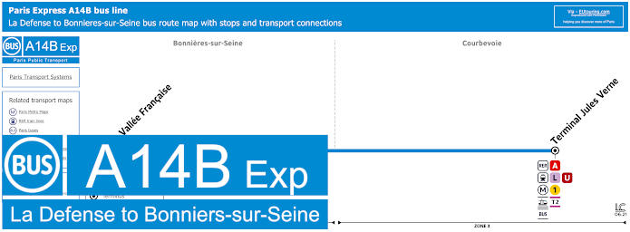
Paris bus Express A14 line La Defense to Bonnieres-sur-Seine with stops and transport connections
Again a direct bus route classed as an Express bus line, this particular Bus Express A14 goes from La Defense - Terminal Jules Verne by the Grande Arche to Bonnieres-sur-Seine - La Vallee Francaise and runs on a Monday to Friday except for holidays, but as you will see from the timetables there are only 3 trips in each direction at peak times.
Paris bus Express A14 line Bonnieres-sur-Seine stops:
La Defense - Terminal Jules Verne, Bonnieres-sur-Seine - La Vallee Francaise.
Paris bus Express A14 line Bonnieres-sur-Seine main transport connections:
Metro line: 1. Train lines: A, L, U. Tram line: T2 Bus line: 45.
Paris bus Express A14 La Defense to Bonnieres-sur-Seine route maps available:
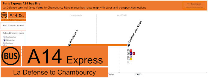
Paris bus Express A14 line La Defense to Chambourcy with stops and transport connections
Now on the street plans for the Grande Arche and La Defense transport hub you will have seen that there are some buses run by a different transport company, and these are the Bus Express A14, with the first one going from La Defense - Terminal Jules Verne to Chambourcy - Renaissance, which is a direct bus route only served at peak times that has no stops in between.
Paris bus Express A14 line Chambourcy stops:
Chambourcy - Renaissance, La Defense - Terminal Jules Verne.
Paris bus Express A14 line Chambourcy main transport connections:
Metro line: 1. Train lines: A, L, U. Tram line: T2. Bus lines: 8, 45, 52.
Paris bus Express A14 La Defense to Chambourcy route maps available:
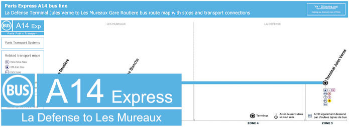
Paris bus Express A14 line La Defense to Les Mureaux with stops and transport connections
With this Bus Express A14 line that travel between La Defense Terminal Jules Verne and Les Mureaux Gare Routiere, has only one additional stop on route, and as you will see from the bus maps and timetables this bus line goes from tarif zone 3 through to tarif zone 5.
Paris bus Express A14 line Les Mureaux stops:
La Defense - Terminal Jules Verne, Vigne Blanche, Les Mureaux - Gare Routiere.
Paris bus Express A14 line Les Mureaux main transport connections:
Metro line: 1. Train lines: A, J, L, U. Tram line: T2 Bus line: 45.
Paris bus Express A14 La Defense to Les Mureaux route maps available:
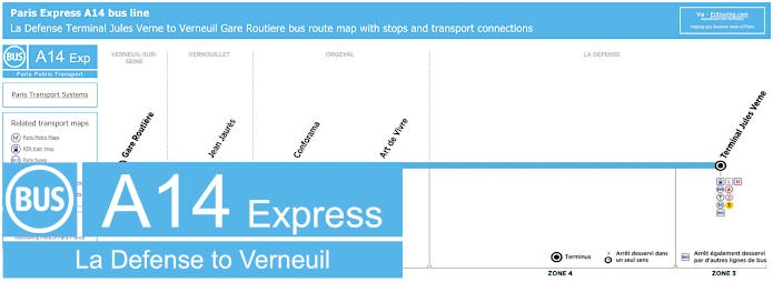
Paris bus Express A14 line La Defense to Verneuil-sur-Seine with stops and transport connections
Traveling between La Defense Terminal Jules Verne and Verneuil-sur-Seine Gare Routiere, this Bus Express A14 line has three additional stops on route, and as you will see from these bus maps and timetables this Paris express bus line also goes from tarif zone 3 through to tarif zone 5.
Paris bus Express A14 line Verneuil-sur-Seine stops:
La Defense - Terminal Jules Verne, Art de Vivre, Conforama, Jean Jaures, Verneuil-sur-Seine - Gare Routiere.
Paris bus Express A14 line Verneuil-sur-Seine main transport connections:
Metro line: 1. Train lines: A, J, L, U. Tram line: T2 Bus line: 45.
Paris bus Express A14 La Defense to Verneuil-sur-Seine route maps available:
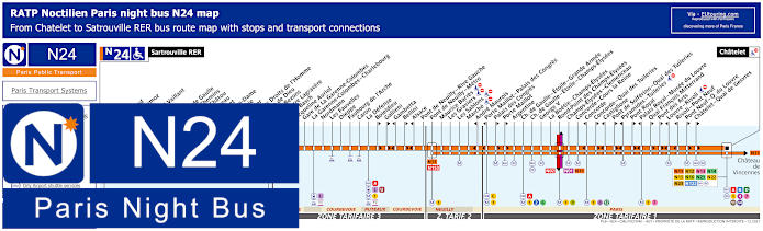
Paris Noctilien night bus N24 map with stops and transport connections
For those of you needing to travel at night, there is the Noctilien Paris night bus service that runs from approximately 12:30am through to 5:30am when other transport have finished for the night. So here we have the RATP Paris Noctilien bus line N24, which travels from Sartrouville RER through to Chatelet in the heart of Paris, and as you can see from the N24 maps and timetables, the bus route goes through several communes, or areas of the Paris region stopping at various transport hubs and key points along the way including La Defense for the Grande Arche, but please note some night bus stops are only served in one direction.
Paris night bus line N24 stops:
Satrouville RER, Poste, Stalingrad, Jean Mermoz, Voltaire, Edouard Vaillant, Eglise, Picardie, Charles de Gaulle, Quatre Chemins, Rue de Chatou, Clemenceau, Condorcet, Val Notre-Dame, La Berthie, Albert 1er, Place des Droits de l'Homme, La Grace de Dieu, Pont de Bezons, Parc Pierre Lagravere, Victor Basch, Jacqueline Auriol, Gare de La Garenne-Colombes, La Garenne-Colombes - Charlebourg, Nordmann, Les Fauvelles, Dieppe, Faubourg de l'Arche, Caron, La Defense, Boieldieu**, Gallieni**, Gambetta*, Bellini**, Alsace*, Pont de Neuilly - Rive Gauche, Pont de Neuilly - Metro, Maurice Barres, Les Graviers, Les Sablons, Marche, Andre Maurois*, Porte Maillot - Palais de Congres*, Palais de Congres**, Porte Maillot**, Argentine, Charles de Gaulle - Etoile - Grande Armee, Charles de Gaulle - Etoile - Champs-Elysees, George V, La Boetie - Champs-Elysees, Rond-Point des Champs-Elysees, Champs-Elysees - Clemenceau, Concorde - Cours la Reine, Concorde*, Concorde - Quai des Tuileries**, Castiglione*, Pont de Solferino - Quai des Tuileries**, Pyramides - Tuileries*, Pont Royal**, Palais Royal - Musee du Louvre*, Quai Francois Mitterrand**, Pont des Arts**, Louvre - Rivoli*, Rivoli - Pont Neuf*, Pont Neuf - Quai du Louvre**, Chatelet - Quai de Gesvres**, Chatelet.
* Stop served in direction of Sartrouville RER. ** Stop served in direction of Chatelet.
Paris night bus line N24 main transport connections:
Metro Lines: 1, 2, 4, 6, 7, 8, 9, 11, 12, 14. Train Lines: A, B, C, D, J, L, U. Tram Line: T2. Bus Lines: N01, N02, N11, N12, N13, N14, N15, N16, N21, N22, N23, N122, N153.
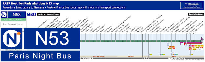
Paris Noctilien night bus N53 map with stops and transport connections
Whereas this shows the Noctilien N53 night bus line that travels from Nanterre - Anatole France through to Gare Saint-Lazare train station also in the heart of Paris, and for getting to or from the Grande Arche and the area late at night you would need the Nanterre - Prefecture RER night bus stop, but please do bear in mind the ticket tariff zones for the cost of travel that are shown on the Noctilien bus maps and timetables.
Paris night bus line N53 stops:
Nanterre - Anatole France, Nanterre - Universite RER, Soufflot, Prefecture des Hauts-de-Seine, Nanterre - Prefecture RER, Esplanade Charles de Gaulle, Prefecture des Hauts-de-Seine, Joliot-Curie - Courbevoie, Palais des Sports, Mairie de Nanterre, Sadi Carnot - Joliot-Curie, Place de la Boule - Joliot-Curie, Place de la Boule - Joffre, Sainte-Genevieve, Boulevard National, Gabriel Peri, Le Gue, Hopital Stell, Place Richelieu, Zurich, Place Besche, Dunant, Lieutenant-Colonel de Montbrison, Place de la Paix, Place Jean Jaures, Croix du Roy, Val d’Or, Garibaldi, Longchamp, De Gaulle, Rue des Bourets - Pont de Suresnes, Les Moulins - Camping, La Muette - Boulainvilliers, Place Possoz, Scheffer, Trocadero, Kleber - Paul Valery, Charles de Gaulle - Etoile - Kleber, Charles de Gaulle - Etoile - Friedland, Balzac, Haussmann - Miromesnil, Saint-Augustin, Saint-Augustin - La Boetie, Pasquier - Anjou, Gare Saint-Lazare.
Paris night bus line N53 main transport connections:
Metro Lines: 1, 2, 3, 6, 9, 12, 13, 14. Train Lines: A, E, J, L. Bus lines: N01, N02, N11, N15, N16, N24, N51, N52, N150, N151, N152, N153, N154.
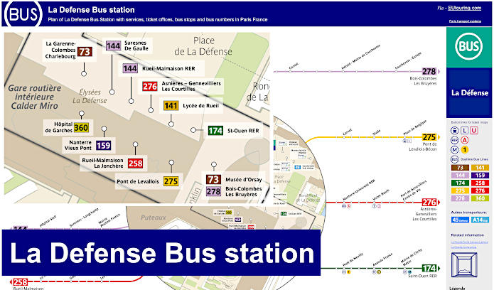
La Defense Bus Station plan of bus stops and bus numbers
Here we have a map showing the Gare Routiere, which is Bus Station in English, that is located right by the Parvis or square next to the Grande Arche de la Defense and this is an indoor bus station called Calder Miro, so you can see the location of the entrance to the services and ticket office along with the position of the various bus stops, both for the RATP Paris bus lines and others from different transporter companies, not forgetting the access points for the La Defense Metro and train station.