How to get to Bercy Arena in Paris using public transport
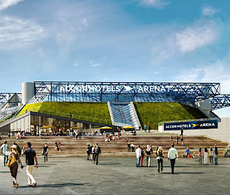
AccorHotels Arena was once called the Palais Omnisports Paris Bercy or POPB, yet having been fully renovated and updated including better disabled access, the AccorHotels Arena is also often referred to as the Bercy Arena due to its location within the Parc de Bercy in Paris. So below you can see how to get to Bercy Arena via public transport including street maps, timetables and plans including access plans, which can all be downloaded to your PC or mobile device in PDF or image formats.
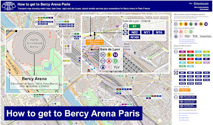
Bercy Arena transport map of Metro lines, trains and bus lines with stops, connections and street plan
Here you can see a street map showing the location of AccorHotels Arena, or Bercy Arena with the different train stations pin-pointed that provide various options for Metro and trains in addition to bus stops for the daytime buses and the Noctilien night buses, which will all get you within walking distance is this impressive Paris Arena that hosts numerous shows and sports events each year.
How to get to Bercy Arena public transport maps available:
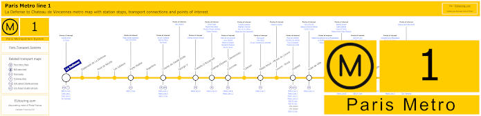
Paris Metro Line 1 map with stations, connections and points of interest
Here we have the Paris Metro line 1 that travels between La Defense Grande Arche and Chateau de Vincennes, and as you can see from the maps this is one option of how to get to Palais des Congres, Bastille and also Bercy Arena via the Gare de Lyon train station.
Metro Line 1 stops:
La Defense, Esplanade de La Defense, Pont de Neuilly, Les Sablons, Porte Maillot, Argentine, Charles de Gaulle Etoile, George V, Franklin D Roosevelt, Champs-Elysees - Clemenceau, Concorde, Tuileries, Palais Royal - Musee du Louvre, Louvre - Rivoli, Chatelet, Hotel de Ville, Saint-Paul, Bastille, Gare de Lyon, Reuilly - Diderot, Nation, Porte de Vincennes, Saint-Mande, Berault, Chateau de Vincennes.
Metro line 1 main transport connections:
Metro Lines: 2, 4, 5, 6, 7, 8, 9, 11, 12, 13, 14. Train Lines: A, B, C, D, L, R, U. Tram Lines: T2, T3a, T3b.
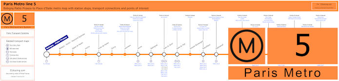
Paris Metro Line 5 map with stations, connections and points of interest
Whereas the Metro Line 5 stops at Gare d'Austerlitz on the opposite side of the River Seine, yet still within easy walking distance of AccorHotels Arena, with Bercy park in Paris, and this metro route goes between Bobigny - Pablo Picasso and Place d'Italie with many stops on route including at Gare du Nord train station where the Eurostar from London arrives.
Metro Line 5 stops:
Bobigny - Pablo Picasso, Bobigny - Pantin - Raymond Queneau, Eglise de Pantin, Hoche, Porte de Pantin, Ourcq, Laumiere, Jaures, Stalingrad, Gare du Nord, Gare de l'Est, Jacques Bonsergent, Republique, Oberkampf, Richard-Lenoir, Breguet - Sabin, Bastille, Quai de la Rapee, Gare d'Austerlitz, Saint-Marcel, Campo-Formio, Place d'Italie.
Metro line 5 main transport connections:
Metro Lines: 1, 2, 3, 4, 6, 7, 7b, 8, 9, 10, 11. Train Lines: B, C, D, E, H, K, P. Tram Lines: T1, T3b.
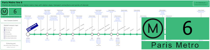
Paris Metro Line 6 map with stations, connections and points of interest
So here we have the Paris Metro line 6 that travels between Nation and Charles de Gaulle - Etoile, which is one way for how to get to the Arc de Triomphe plus several other Metro stations on route that have transport connections, and as you can see from the Metro maps for getting to AccorHotels Arena you would need the Bercy stop, which is actually the closest Metro station to this impressive sports and entertainment venue in Paris.
Metro line 6 stops:
Charles de Gaulle - Etoile, Kleber, Boissiere, Trocadero, Passy, Bir-Hakeim, Dupleix, La Motte-Picquet - Grenelle, Cambronne, Sevres - Lecourbe, Pasteur, Montparnasse - Bienvenue, Edgar Quinet, Raspail, Denfert-Rochereau, Saint-Jacques, Glaciere, Corvisart, Place d'Italie, Nationale, Chevaleret, Quai de la Gare, Bercy, Dugommier, Daumesnil, Bel-Air, Picpus, Nation.
Metro line 6 main transport connections:
Metro Lines: 1, 2, 4, 5, 7, 8, 9, 10, 12, 13, 14. Train Lines: A, B, C, N. Bus Line: OrlyBus.
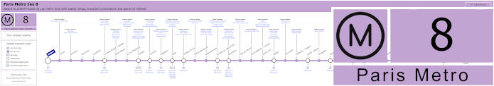
Paris Metro Line 8 map with stations, connections and points of interest
Although here you have the maps for the Metro line 8, also run by the transport company RATP, which goes between Balard and Creteil - Pointe du Lac, and this is one of the options for event venues like Bastille for getting to Opera Bastille and the famous square plus the Daumesnil stop for getting to Bercy Arena, along with Metro stops for other tourist attractions like Madeleine and Porte Doree. etc.
Metro line 8 stops:
Balard, Lourmel, Boucicaut, Felix Faure, Commerce, La Motte-Picquet - Grenelle, Ecole Militaire, La Tour-Maubourg, Invalides, Concorde, Madeleine, Opera, Richelieu-Drouot, Grands Boulevards, Bonne Nouvelle, Strasbourg - Saint-Denis, Republique, Filles du Calvaire, Saint-Sebastien - Froissart, Chemin Vert, Bastille, Ledru-Rollin, Faidherbe - Chaligny, Reuilly - Diderot, Montgallet, Daumesnil, Michel Bizot, Porte Doree, Porte de Charenton, Liberte, Charenton - Ecoles, Ecole Veterinaire de Maisons-Alfort, Maisons-Alfort - Stade, Maisons-Alfort - Les Juilliottes, Creteil - L'Echat, Creteil - Universite, Creteil - Prefecture, Creteil - Pointe du Lac.
Metro line 8 main transport connections:
Metro Lines: 1, 3, 4, 5, 6, 7, 9, 10, 11, 12, 13, 14. Train Lines: A, C. Tram Lines: T2, T3a. Bus Lines: RoissyBus, TVM (14).
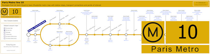
Paris Metro Line 10 map with stations, connections and points of interest
However these maps show the Metro line 10 that travels from the Gare d'Austerlitz train station, which is the stop you need for Bercy Arena formerly known as the POPB and going to Boulogne - Pont de Saint-Cloud, as you can see the line splits at a specific point, so if you require one of these stops such as the Porte d'Auteuil for getting to the Hippodrome de Longchamp horserace course, then please be aware of your direction of travel.
Metro line 10 stops:
Boulogne - Pont de Saint-Cloud, Boulogne - Jean Jaures, Porte d'Auteuil, Michel-Ange - Auteuil, Eglise d'Auteuil, Michel-Ange - Molitor, Chardon - Lagache, Mirabeau, Javel - Andre Citroen, Charles Michels, Avenue Emile Zola, La Motte-Picquet - Grenelle, Segur, Duroc, Vaneau, Sevres - Babylone, Mabillon, Odeon, Cluny - La Sorbonne, Maubert - Mutualite, Cardinal Lemoine, Jussieu, Gare d'Austerlitz.
Metro line 10 main transport connections:
Metro Lines: 4, 5, 6, 7, 8, 9, 10, 12, 13. Train Lines: B, C. Tram Line: T2.
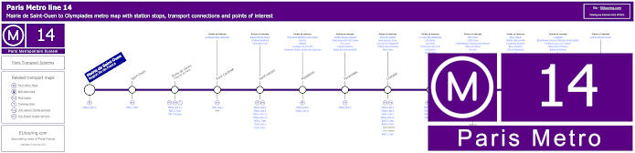
Mairie de Saint-Ouen (Region Ile-de-France), Saint-Ouen, Porte de Clichy (Tribunal de Paris), Pont Cardinet, Saint-Lazare, Madeleine, Pyramides, Chatelet, Gare de Lyon, Bercy, Cour Saint-Emilion, Bibliotheque Francois Mitterrand, Olympiades.
Metro line 14 main transport connections:
Metro Lines: 1, 3, 4, 6, 7, 8, 9, 11, 12, 13. Train Lines: A, B, C, D, E, J, L, R. Tram Lines: T3a Walk, T3b.
Some attractions close to Metro line 14 stops:
Square Marcel Pagnol, Chapelle Expiatoire, Cafe Marco Polo, Place de la Madeleine and Church, Fauchon, Hediard, La Maison de la Truffe, Fragonard Theatre Musee des Capucines, La Belle Epoque Cabaret, Palais Royal and Petit Canon, The Louvre, Tuileries Gardens, Musee des Arts Decoratifs , Place de Chatelet, Saint-Jacques Tower, Dans la Noir Restaurant, Fontaine des Innocents, River Seine, Le Train Bleu Restaurant, Cafe Barge, Les Docks, l'Improviste Jazz Club, Le Playtime, Le VIP Paris, Bercy Park, POPB Arena, Cinematheque Francaise and Museum, Dame de Canton, Nix Nox, Bercy Village, Yitzhak Rabin Garden, Fairground Museum, Bercy Pavilions, Chai 33 Restaurant, Le Batofar, Bibliotheque Francois Mitterand Forest Garden, Globes of Louis XIV Museum, Allee Arthur Rimbaud, Bateau El Alamein, Cyprian Norwid Garden.
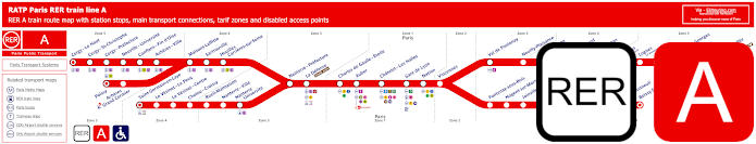
Red RER A train line map showing station stops, line branches, transport connections and zones
These maps show the RER A train line run by RATP that travels out from central Paris with its many transport connections to various areas within Ile de France and is an option for how to get to Disneyland Paris via the Marne-la-Vallee Chessy stop, yet for Bercy Arena you would need the Gare de Lyon train station, which is an approximate walking distance of 850 metres from this major events venue.
Paris RER A train line stops:
Cergy le Haut*, Cergy Saint-Christophe, Cergy Prefecture, Neuville Universite, Conflans Fin d’Oise, Acheres Ville, Maisons-Laffitte, Sartrouville, Houilles - Carrieres sur Seine, Nanterre Prefecture, La Defense (Grande Arche), Charles de Gaulle Etoile, Auber, Chatelet Les Halles, Paris Gare de Lyon, Nation, Vincennes, Val de Fontenay, Neuilly Plaisance, Bry sur Marne, Noisy le Grand - Mont d’Est, Noisy Champs, Noisiel, Lognes, Torcy, Bussy Saint-Georges, Val d’Europe, Marne la Vallee - Chessy (Parcs Disneyland)*, Poissy*, Acheres - Grand Cormier, Saint-Germain en Laye*, Le Vesinet Le Pecq, Le Vesinet Centre, Chatou Croissy, Rueil Malmaison, Nanterre Ville, Nanterre University, Fontenay sous Bois, Nogent sur Marne, Joinville le Pont, Saint-Maur - Creteil, Le Parc de Saint-Maur, Champigny, La Varenne - Chennevieres, Sucy Bonneuil, Boissy Saint-Leger*.
* Terminus Points.
Paris RER A train line main transport connections:
Metro Lines: 1, 2, 3, 4, 6, 7, 8, 9, 11, 14. Train Lines: B, D, E, J, L, R, U, TGV. Tram Lines: T2, 13. Bus Lines: 393, RoissyBus, TVM (14).
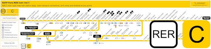
Yellow RER C train line map showing station stops, line branches, transport connections and zones
The RER C train line is operated by SNCF and has several stops within central Paris including the Gare d'Austerlitz referred to as Paris Austerlitz on the RER C maps, for getting to Bercy Arena on the opposite side of the River Seine, and just like the other train lines, there are various branches and this is one of the options for how to get to Chateau de Versailles via the Versailles Chateau Rive Gauche stop, which is the closest to the famous royal castle.
Paris RER C train line stops:
Pontoise*, St-Ouen l'Aumone, St-Ouen l'Aumone - Liesse, Pierrelaye, Montigny Beauchamp, Francoville - Le Plessis-Bouchard, Cernay, Ermont Eaubonne, St-Gratien, Epinay-sur-Seine, Gennevilliers, Les Gresillons, St-Ouen, Porte de Clichy, Pereire Levallois, Neuilly - Porte Maillot (Palais des Congres), Avenue Foch, Avenue Henri Martin, Boulainvilliers, Avenue du Pdt Kennedy (Maison de Radio France), Champ de Mars (Tour Eiffel), Pont d'Iena, Invalides, Musee d'Orsay, St-Michel (Notre Dame), Paris Gare d'Austerlitz, Bibliotheque Francois Mitterrand, Ivry-sur-Seine, Vitry-sur-Seine, Les Ardoines, Choisy le Roi, Villeneuve le Roi, Ablon, Athis Mons, Juvisy, Savigny-sur-Orge, Epinay-sur-Orge, Ste-Genevieve des Bois, St-Michel-sur Orge, Bretigny, Marolles en Hurepoix, Bouray, Lardy, Chamarande, Etrechy, Etampes, St-Martin d'Etampes*, Versailles Chateau Rive Gauche*, Porchefontaine, Viroflay Rive Gauche, Chaville - Velizy, Meudon - Val Fleury, Issy, Issy - Val de Seine, Pont du Garigliano (Hopital Europeen Georges Pompidou), Javel, St-Quentin en Yvelines*, St-Cyr, Versailles Chantiers**, Petit Jouy les Loges, Jouy en Josas, Vauboyen, Bievres, Igny, Massy Palaiseau**, Massy Verrieres, Chemin d'Antony, Rungis La Fraternelle, Pont de Rungis (Aeroport d'Orly), Orly Ville, Les Saules, Longjumeau, Chilly Mazarin, Gravigny Balizy, Petit Vaux, La Norville (St-Germain les Arpajon), Arpajon, Egly, Breuillet (Bruyeres le Chatel), St-Cheron, Sermaise, Dourdan, Dourdan la Foret*.
* Terminus Points. ** RER C Transfer Points.
Paris RER C train line main transport connections:
Metro Lines: 1, 2, 3, 4, 5, 6, 8, 9, 10, 12, 13, 14. Train Lines: B, D, H, J, N, U, TGV, TER. Tram Lines: T1, T2, T3a, T3b, T6, T7, T8, T9, T11, T13. Bus Lines: 183, 393, PC (98), TVM (14).
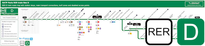
Green RER D train line map showing station stops, line branches, transport connections and zones
Yet the RER D train line travels from Creil and then branches off to different areas of the Paris region and is one of the options for getting to the Stade de France for entertainment and sports events via the Stade de France - Saint-Denis stop but also for getting to the Bercy Arena formerly the POPB and now called AccorHotels Arena, which would be via the Paris Gare de Lyon station.
Paris RER D train line stops:
Creil*, Chantilly - Gouvieux, Orry-la-Ville - Coye-la-Foret, La Borne Blanche, Survilliers - Fosses, Louvres, Les Noues, Goussainville, Villiers-le-Bel - Gonesse - Arnouville, Garges - Sarcelles, Pierrefitte - Stains, Saint-Denis, Stade de France - Saint-Denis, Paris Gare du Nord, Chatelet - Les-Halles, Paris Gare de Lyon, Maisons-Alfort - Alfortville, Le Vert de Maisons, Creteil - Pompadour, Villeneuve - Triage, Villeneuve - Saint-Georges, Montgeron-Crosne, Yerres, Brunoy, Boussy - Saint-Antoine, Combs-la-Ville - Quincy, Lieusaint-Moissy, Savigny-le-Temple - Nandy, Cesson, Le Mee-sur-Seine, Melun*, Vigneux-sur-Seine, Juvisy**, Viry Cahatillon**, Ris - Orangis, Grand-Bourg, Evry - Val de Seine, Grigny Centre, Orangis - Bois de l'Epine, Evry - Courcouronnes (Centre), Le Bras de Fer (Evry Genepole), Corbeil - Essonnes**, Essonnes - Robinson, Villabe, Le Plessis - Chenet, Le Coudray - Montceaux, Saint-Fargeau, Ponthierry - Pringy, Poissise-le-Roi, Vosves, Melun**, Moulin Galant, Mennecy, Ballancourt, La Ferte-Alais, Boutigny, Maisse, Buno Gironville, Boigneville, Malesherbes*.
* Terminus points. ** RER D Transfer points.
Paris RER D train line main transport connections:
Metro Lines: 1, 2, 4, 5, 7, 11, 14. Train Lines: A, B, C, E, H, K, P, R, TGV, TER. Tram Lines: T1, T5, T8, T11. Bus Lines: 20, 393, Senlis, TVM (14), Tzen 1.
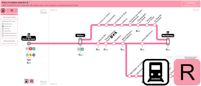
Transilien train line R map showing station stops, line branches, transport connections and zones
Whereas here you can see the Transilien R train line, which is one of the Ile de France regional train lines run by the transport company SNCF, and as you can see from the maps, shown in pink this starts from Gare de Lyon, which is the train station you would need for getting to Bercy Arena, it then goes through to Melun, Montereau and Montargis, and is also the public transport option for how to get Chateau de Fontainebleau from Paris alighting at the Fontainebleau Avon stop.
Paris train line R stops:
Paris Gare de Lyon*, Melun**, Livy sur Seine, Chartrettes, Fontaine le Port, Hericy, Vulaines sur Seine - Samoreau, Champagne sur Seine, Vernou sur Seine, La Grande Paroisse, Montereau*, Bois le Roi, Fontainebleau - Avon (Chateau), Thomery, Moret - Veneux les Sablons, St Mammes, Montigny sur Loing, Bourron - Marlotte Grez, Nemours St-Pierre, Bagneaux sur Loing, Souppes Chateau Landon, Dordives, Ferrieres Fontenay, Montargis*.
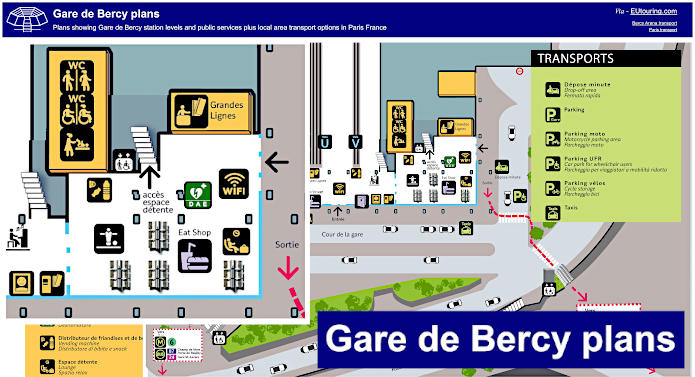
Gare de Bercy plans of station levels, public services and local transport options
However here we have a plan for the Gare de Bercy that has a full name of Paris Bercy Bourgogne - Pays d'Auvergne but is also known as Gare de Paris Bercy, and this particular train station serves TER and Intercities trains that cover different regions and areas of France and see you can see the live arrival and departure times below.
In addition to the train station plan showing the levels, it also shows the public services and facilities such as toilets, ticket machines, lounges, WiFi areas and much more, not forgetting the immediate area and various transport options including taxi ranks and parking.
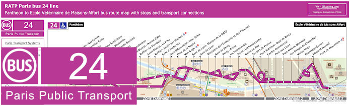
RATP Paris bus 24 map with stops, connections and street plan
Now here we have the Paris bus line 24 run by the transport company RATP, and as you can see from the maps and timetables, there is a bus stop called Bercy Arena, and this is the closest stop to the AccorHotels Arena at Parc de Bercy, and travelling from Ecole Veterinaire de Maisons-Alfort, this is also how to get to the Pantheon, being the other terminus.
Paris bus line 24 stops:
Pantheon, Saint-Jacques - Gay-Lussac*, Musee et Institut Curie**, Feuillantines*, Ecole Normale Superieure**, Berthollet - Vauquelin, Monge - Claude Bernard, Les Gobelins*, Censier - Daubenton**, Saint-Marcel - Jeanne d’Arc*, Buffon - La Mosquee**, Saint-Marcel - La Pitie*, Buffon - Jardin des Plantes**, Gare d'Austerlitz, Gare d'Austerlitz - Cour Seine*, Quai de la Rapee**, Van Gogh*, Gare de Lyon - Maison de la RATP*, Gare de Lyon**, Ministere de l’Économie et des Finances, Gare de Bercy**, Bercy - Arena, Lachambeaudie**, Dijon - Lachambeaudie*, Baron Le Roy, Terroirs de France, Pont National - Quai de Bercy**, Centre Commercial, Port aux Lions, Pont Nelson Mandela, Les Berges de Charenton, Victor Hugo, Charenton-Ecoles, Edmond Nocard**, Pont de Charenton, Ecole Veterinaire de Maisons-Alfort.
* Served in direction of Ecole Veterinaire de Maisons-Alfort. ** Served in direction of The Pantheon.
Paris bus line 24 main transport connections:
Metro Lines: 1, 5, 6, 7, 8, 10, 14. Train Lines: A, B, C, D, R.
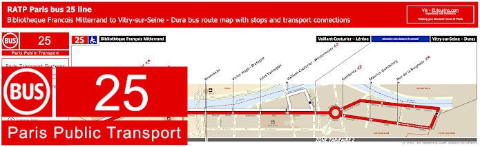
RATP Paris bus line 25 with stops, connections and street plan
Yet the RATP bus line 25 goes from Bibliotheque Francois Mitterrand through to Vitry-sur-Seine - Duras, although as you can see from the maps and timetables on a Saturday it terminates at Vaillant-Couturier - Lenine, with the stops in between these points also only being served at specific hours on a Saturday compared to the rest of the week. However, getting back to Bercy Arena, you will find that the nearest stop for this bus route is on the opposite side of the River Seine called the Pont de Tolbiac stop.
Paris bus line 25 stops:
Bibliotheque Francois Mitterrand, Pont de Tolbiac, Thomas Mann, Watt, Bruneseau, Victor Hugo - Bretagne, Jules Vanzuppe, Vaillant-Couturier - Westermeyer**, Vaillant-Couturier - Lenine, Gambetta*, Maurice Gunsbourg* **, Rue de la Baignade* **, Vitry-sur-Seine - Duras*.
*Stops not served on a Saturday and remainder only served at specific times. ** Only served in a particular direction.
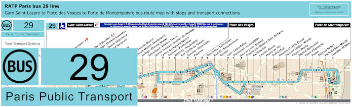
RATP Paris bus 29 map with stops, connections and street plan
Whereas the Paris bus route 29 travels between the Gare Saint-Lazare train station and Porte de Montempoivre, yet please do look at the maps and timetables carefully, as on a Sunday the service only goes from Gare Saint-Lazare to Place des Vosges at certain hours, which means that you would not be able to access the Gare de Lyon - Diderot bus stop you would need for Bercy Arena if travelling in that direction.
Paris bus line 29 stops:
Gare Saint-Lazare, Havre - Haussmann, Auber, Opera, Opera - Quatre Septembre, Petits Champs - Danielle Casanova**, Richelieu - Quatre Septembre*, Bibliotheque Nationale**, Bourse*, Mairie du 2e*, Victoires, Louvre - Etienne Marcel**, Etienne Marcel - Montmartre, Turbigo - Etienne Marcel, Sebastopol - Etienne Marcel, Grenier St-Lazare - Quartier de l’Horloge, Centre Georges Pompidou*, Archives - Rambuteau*, Archives - Haudriettes**, Rue Vieille du Temple, Turenne - Saint-Gilles**, Payenne*, Place des Vosges*, Tournelles-Saint-Gilles**, Bastille - Beaumarchais, Bastille, Lyon - Ledru-Rollin*, Daumesnil - Ledru-Rollin**, Gare de Lyon - Diderot*, Daumesnil - Diderot (Gare de Lyon), Rambouillet, Charles Bossut, Mairie du 12e, Dubrunfaut, Daumesnil - Felix Eboue, Docteur Goujon - Reuilly, Picpus - Reuilly, Hopital Rothschild, Fabre d’Eglantine, Picpus, Docteur Netter, Porte de Saint-Mande, J. Lemaitre - M. Ravel*, Porte de Montempoivre.
* Served in direction of Porte de Montempoivre. ** Served in direction of Gare Saint-Lazare.
Paris bus line 29 main transport connections:
Metro Lines: 1, 3, 4, 5, 6, 7, 8, 9, 11, 12, 13, 14. Train Lines: A, D, E, J, L, R. Tram Line: T3a.
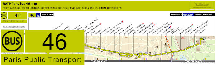
RATP Paris bus line 46 with stops, connections and street plan
The bus line 46 is one of the options for how to get to Chateau de Vincennes as it travels to here from Gare de l’Est, or Paris East train station, yet for getting to Bercy Arena now known as AccorHotels Arena, you would need the Montgallet bus stop, which is an approximately walking distance of 1500 metres from this impressive world class events venue.
Paris bus line 46 stops:
Gare de l'Est, Magenta - Saint-Martin**, Verdun, Chateau Landon, Louis Blanc**, Canal Saint-Martin, Colonel Fabien**, Grange aux Belles - Juliette Dodu*, Sambre et Meuse**, Hopital Saint-Louis, Alibert*, Goncourt, Fontaine au Roi, Parmentier - Republique, Saint-Ambroise, Chemin Vert, Voltaire - Leon Blum, Gymnase Japy*, Godefroy Cavaignac**, Charonne - Chanzy, Faidherbe - Chaligny, Reuilly - Diderot, Montgallet, Rue de la Gare de Reuilly, Daumesnil - Felix Eboue, Sidi Brahim, Michel Bizot, Porte Doree - Daumesnil**, Porte Doree, Parc Zoologique, Alphand**, Demi-Lune - Parc Zoologique, Tourelle - Daumesnil, Parc Floral, Chateau de Vincennes.
* Stop served in direction of Chateau de Vincennes. ** Stop served in direction of Gare de l'Est.
Paris bus line 46 main transport connections:
Metro lines: 1, 2, 3, 4, 5, 6, 7, 7bis, 8, 9, 11 Train lines: E, P Tram lines: T3a
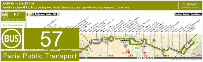
RATP Paris bus 57 map with stops, connections and street plan
Here you can see the maps and timetables for the RATP bus line 57 travelling between Arcuil - Laplace RER and Porte de Bagnolet - Louis Ganne, although please take care of your direction of travel as some stops such as Van Gogh are only served in a particular direction, so the easiest options for getting to Bercy Arena is the Gare de Lyon - Diderot bus stop or the Gare d'Austerlitz stop.
Paris bus line 57 stops:
Arcuil - Laplace RER, Maison des Examens RER**, Chaperon Vert*, Benoit Malon, Fraysse, Rue d’Arcueil**, Cite Verte**, Bout du Rang*, Reine Blanche*, Division Leclerc - Mediatheque**, Raspail - Jean Jaures*, Mairie de Gentilly**, Verdun - Victor Hugo**, Verdun*, Poterne des Peupliers, Abbe Georges Henocque, Bobillot - Tolbiac**, Moulin des Pres - Tolbiac*, Verlaine, Moulin des Pres**, Place d'Italie - Blanqui**, Place d'Italie - Bobillot*, Place d'Italie - Mairie du 13e, Rubens - Ecole des Arts et Metiers, Jenner - Jeanne d'Arc, Saint-Marcel - La Pitie, Gare d'Austerlitz, Gare d'Austerlitz - Cour Seine*, Van Gogh*, Quai de la Rapee**, Gare de Lyon - Diderot, Daumesnil - Diderot, Hopital Saint-Antoine, Reuilly - Diderot, Pierre Bourdan, Nation - Diderot, Nation - Taillebourg, Avron, Buzenval, Maraichers, Porte de Montreuil, Place de la Pte de Montreuil**, Stade Dejerine, Serpollet, Porte de Bagnolet - Louis Ganne.
* Served in direction of Porte de Bagnolet - Louis Ganne. ** Served in direction of Arcuil - Laplace RER.
Paris bus line 57 main transport connections:
Metro Lines: 1, 2, 3, 5, 6, 7, 8, 9, 10, 14. Train Lines: A, B, C, D, R. Tram Lines; T3a, T3b.
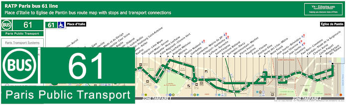
RATP Paris bus 61 map with stops, connections and street plan
Just like bus route 57, the Paris bus line 61 has the option of the Gare d'Austerlitz - Cour Seine or Gare de Lyon - Diderot stops closest to Bercy arena, and travelling between Eglise de Pantin and Place d'Italie there are over 40 other bus stops on route, which is also an option for how to get to the Cite de la Mode et du Design and other tourist attractions in Paris.
Paris bus line 61 stops:
Place d'Italie, Place d’Italie - Auriol, Les Alpes, Nationale, Chevaleret, Quai de la Gare, Quai d'Austerlitz, Cite de la Mode et du Design, Gare d'Austerlitz - Cour Seine, Quai de la Rapee, Gare de Lyon - Diderot, Daumesnil - Ledru-Rollin, Ledru-Rollin - Faubourg Saint-Antoine, Charonne - Keller, Basfroi, Voltaire - Leon Blum, Saint-Maur - Servan, Roquette - Pere Lachaise, Folie-Regnault - Chemin Vert, Pere Lachaise, Auguste Metivier, Muriers, Martin Nadaud, Gambetta, Gambetta - Mairie du 20e, Pelleport - Gambetta, Lefevre - Surmelin, Saint-Fargeau, Adrienne Bolland, Surmelin - Darcy, Menilmontant - Mortier, Pierre Foncin, Fougeres, Freres Flavien, Docteur Gley, Porte des Lilas - Metro, Rene Fonck, Jean Jaures - Belvedere, Place Severine, Jean Jaures, Cimetiere, Paul Bert - Cimetiere, Candale - Stade de la Seigneurie, Charles Auray, Cecile Faguet, Manufacture des Tabacs, Eglise de Pantin.
Paris bus line 61 main transport connections:
Metro Lines: 1, 2, 3, 3bis, 5, 6, 7, 8, 9, 10, 11, 14. Train Lines: A, C, D, R. Tram Line: T3b.
RATP Paris bus 63 map with stops, connections and street plan
So these maps and timetables show the RATP Paris bus line 63 that goes from Gare de Lyon train station, which this and other stops such as Van Gogh are the closest bus stops you can get to Bercy Arena. From the train station hub it goes to Porte de la Muette , yet as you can see, of a weekend the bus travels further to Jardin d'Acclimatation tourist attraction along with Fondation Louis Vuitton, but this is also an option for getting to Les Invalides via the Pont Alexandre III or Assemblee Nationale bus stops.
Paris bus line 63 stops:
Jardin d'Acclimatation*, Fondation Louis Vuitton*, Route de Suresnes*, Pelouse de la Muette*, Porte de la Muette, Pte de la Muette - Octave Feuillet, Victor Hugo - Henri Martin, Pompe - Mairie du 16e, Sablons - Cortambert, Georges Mandel - Trocadero, Trocadero, Albert de Mun, Iena, Alma - Marceau, Bosquet - Rapp, Jean Nicot - Eglise Americaine, Pont des Invalides - Place de Finlande, Pont Alexandre III, Assemblee Nationale, Lille - Universite, Solferino - Bellechasse, Rue du Bac - Rene Char, Charlotte Perriand***, Sevres - Babylone***, Saint-Guillaume**, Michel Debre***, Saint-Germain-des-Pres**, Eglise Saint-Sulpice***, Seine - Buci**, Saint-Germain - Odeon, Cluny, Dante**, College de France***, Maubert - Mutualite**, Monge - Mutualite***, Institut du Monde Arabe***, Saint-Germain - Cardinal Lemoine**, Universite Paris 6, Cuvier, Jardin des Plantes**, Gare d'Austerlitz***, Gare d'Austerlitz - Cour Seine**, Quai de la Rapee***, Van Gogh**, Gare de Lyon.
* Only served on weekends, French public holidays and during school holidays. ** Stop served in direction of Paris Gare de Lyon. *** Stop served in direction of Jardin d'Acclimatation and Porte de la Muette.
Paris bus line 63 main transport connections:
Metro lines: 1, 4, 5, 6, 8, 9, 10, 12, 13, 14. Train lines: A, C, D, R.
RATP Paris bus line 64 with stops, connections and street plan
For the Paris bus line 64 there is a bus stop called Dijon - Lachambeaudie that will get you close to the AccorHotels Arena formerly known as the POPB or Bercy Arena, yet a little further and you have the Parc de Bercy stop within the interesting park that many do not realise even exists! So when you look at these maps and timetables for bus 64 you will also see many transport connections to other public transport in Paris in addition to it having a terminus of Denfert-Rochereau where you can catch the OrlyBus to Orly Airport.
Paris bus line 64 stops:
Porte de Lilas, Porte des Lilas - Metro, Piscine des Tourelles, Saint-Fargeau, Pelleport - Gambetta, Gambetta - Mairie du 20e, Gambetta - Pyrenees, Ramus, Pyrenees - Bagnolet, Orteaux, Maraichers, La Plaine, Cours de Vincennes, Avenue de Saint-Mande, Hopital Trousseau, Louis Braille, Picpus - Reuilly, Docteur Goujon - Reuilly, Daumesnil - Felix Eboue, Charenton - Wattignies, Dijon - Lachambeaudie, Parc de Bercy, Pont de Tolbiac, Bibliotheque - Chevaleret, Patay - Tolbiac, Olympiades, Tolbiac - Baudricourt, Choisy - Tolbiac, Parc de Choisy, Place d’Italie - Choisy, Place d’Italie - Blanqui, Corvisart, Glaciere - Auguste Blanqui, Dareau - Saint-Jacques, Denfert-Rochereau - Saint-Jacques*, Denfert-Rochereau.
* Only served in the direction of Denfert-Rochereau.
RATP Paris bus 71 map with stops, connections and street plan
You will find that the Paris bus line 71 has options for how to get to Zenith Paris and the Grande Halle de la Villette via the start and end point of Porte de la Villette, yet you will also find that this Paris bus route is great for accessing many event and entertainment venues in Paris including the AccorHotels Arena via the Bercy - Arena stop, which also used to be known as the POPB, and as you can see from the maps the line terminates at Bibloitheque Francois Mitterrand.
Paris bus line 71 stops:
Porte de la Villette, Cambrai**, Flandre - Alphonse Karr, Flandre, Canal de l'Ourcq, Ourcq - Jean Jaures, Ourcq, Goubet, D'Hautpoul, Manin, Botzaris, Alouettes, Buttes Chaumont, Pyrenees - Belleville, Julien Lacroix, Belleville, Ramponeau, Couronnes, Belleville - Menilmontant, Menilmontant - Nanettes, Pere Lachaise, Roquette - Pere Lachaise, Philippe Auguste, Charonne - Philippe Auguste, Philippe Auguste - Dumas, Nation - Philippe Auguste, Fabre d'Eglantine, Hopital Rothschild, Picpus - Reuilly, Docteur Goujon - Reuilly, Daumesnil - Felix Eboue, Charenton - Wattignies, Dugommier, Gare de Bercy, Bercy - Arena, Quai de la Gare, Emile Durkheim**, Pont de Tolbiac*, Bibliotheque Francois Mitterrand.
* Stop served in direction of Porte de la Villette. ** Stop served in direction of Bibliotheque Francois Mitterrand.
Paris bus line 71 main transport connections:
Metro Lines: 1, 2, 3, 5, 6, 7, 7bis, 8, 11, 14. Train Lines: A, C. Tram Lines: T3a, T3b.
RATP Paris bus 72 map with stops, connections and street plan
Although the Paris bus line 72 goes from Parc de Saint-Cloud to Gare de Lyon train station, which is the stop you would need for Bercy Arena, yet as you can see from the street maps and timetables, this bus route is also a way of getting to the Grand Palais and many other tourist attractions, yet please note that many stops such as Palais Royal - Musee du Louvre are only served in a particular direction.
Paris bus line 72 stops:
Parc de Saint-Cloud, La Colline, Pont de Saint-Cloud - Rive Gauche, Pont de Saint-Cloud - Albert Kahn, Rhin et Danube - Metro, Ancienne Mairie, Route de la Reine - Jean Jaures, Victor Hugo, La Tourelle, Porte de Saint-Cloud, Porte de Saint-Cloud - Murat, Versailles - Chardon Lagache, Versailles - Exelmans, Victorien Sardou, Wilhem, Pont Mirabeau, Degas, Radio France - Pont de Grenelle, Radio France, Lamballe - Ankara, Pont de Bir-Hakeim, Le Notre*, Pont d’Iena, Musee d’Art Moderne - Palais de Tokyo, Alma - Marceau, Palais de la Decouverte, Grand Palais, Cours la Reine - Chevaux de Marly*, Concorde*, Concorde - Quai des Tuileries**, Pont de Solferino - Quai des Tuileries**, Castiglione*, Pont Royal**, Pyramides - Tuileries*, Quai Francois Mitterrand**, Palais Royal - Musee du Louvre*, Louvre - Rivoli*, Pont des Arts**, Pont Neuf - Quai du Louvre**, Rivoli - Pont Neuf*, Rivoli - Chatelet*, Chatelet - Quai de Gesvres**, Hotel de Ville, Rue Vieille du Temple - Mairie du 4e*, Pont Louis Philippe**, Pont Marie*, Sully Morland, Port Henri IV**, Port de L'Arsenal*, Quai de la Rapee*, Pont Charles De Gaulle, Van Gogh**, Gare de Lyon.
* Served in direction of Parc de Saint-Cloud. ** Served in direction of Gare de Lyon.
Paris bus line 72 main transport connections:
Metro Lines: 1, 4, 5, 6, 7, 8, 9, 10, 11, 12, 13, 14. Train Lines: A, B, C, D, R.
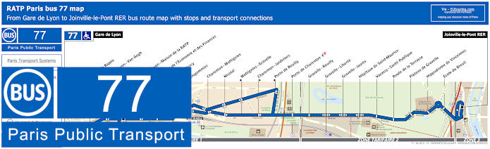
RATP Paris bus 77 map with stops, connections and street plan
Whereas the RATP bus line 77 will get you even closer to the AccorHotels Arena, or Bercy Arena, due it stopping at the Gare de Bercy as you can see from the maps and timetables, with the route travelling between Gare de Lyon and Joinville-le-Pont RER. In addition, the Paris bus 77 is also an option for getting to the Hippodrome de Vincennes horse racing course, Stade Leo Lagrange stadium, and tourist attractions like Parc Zoologique de Paris, etc.
Paris bus line 77 stops:
Gare de Lyon, Quai de la Rapee, Gare de Lyon - Van Gogh, Gare de Lyon - Maison de la RATP, Ministere de l’Économie et des Finances, Gare de Bercy, Dugommier, Charenton - Wattignies, Nicolai, Wattignies - Gravelle, Charenton - Jardiniers, Porte de Reuilly, Porte de Charenton, Gravelle - Reuilly, Gravelle - Liberte, Gravelle - Jaures, Hopitaux de Saint-Maurice, Vacassy - Sante Publique, Route de la Terrasse, Plateau de Gravelle, Hippodrome de Vincennes, Ecole du Breuil, Joinville-le-Pont RER.
Paris bus line 77 main transport connections:
Metro Lines: 1, 6, 8, 14. Train lines: A, D, R. Tram Line: T3a.
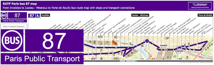
RATP Paris bus 87 map with stops, connections and street plan
Yet the RATP Paris bus line 87 travels from Porte de Reuilly with a mid point main stop of Jussieu - Mineraux and then travels on to Invalides for Les Invalides, and this bus route is how to get to Bastille along with AccorHotels Arena via the Gare de Bercy bus stop, yet please look at the street maps and timetables carefully as there are numerous bus stops that are only served in one direction.
Paris bus line 87 stops:
Invalides, Pont de la Concorde*, Assemblee Nationale, Lille-Universite**, Solferino - Bellechasse**, Henry de Montherlant*, Rue du Bac - Rene Char**, Saint-Guillaume**, Pont du Carrousel - Quai Voltaire*, Pont des Arts - Quai de Conti*, Saint-Germain-des-Pres**, Pont Neuf - Quai des Grands Augustins*, Seine - Buci**, Saint-Germain - Odeon**, Saint-Michel*, Cluny**, Notre-Dame - Quai de Montebello*, Dante**, Maubert - Mutualite**, Pont de l'Archeveche*, Saint-Germain - Cardinal Lemoine**, Jussieu - Mineraux, Pont de la Tournelle - Cardinal Lemoine*, Institut du Monde Arabe**, Pont Sully - Quai de Bethune, Sully - Morland, Bastille - Henri IV, Bastille, Lyon - Ledru-Rollin, Gare de Lyon - Diderot, Gare de Lyon - Van Gogh**, Gare de Lyon*, Gare de Lyon - Maison de la RATP**, Min. de l'Economie et des Finances, Gare de Bercy, Dugommier, Charenton - Wattignies, Nicolai, Charenton - Jardiniers**, Wattignies - Gravelle*, Porte de Charenton**, Porte de Reuilly.
* Bus stop served in direction of Invalides. ** Bus stop served in direction of Porte de Reuilly.
Paris bus line 87 main transport connections:
Metro Lines: 1, 4, 5, 6, 7, 8, 10, 12, 13, 14. Train Lines: A, B, C, D, R. Tram Line: T3a.
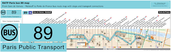
RATP Paris bus 89 map with stops, connections and street plan
You will find that the bus line 89 travels between Gare de Vanves - Malakoff and Porte de France and on route you will see stops such as Quai de la Gare for getting to Bercy Arena, which is the nearest stop to the impressive events arena on the opposite side of the River Seine, although please be aware that many bus stops are direction dependant such as the Musee du Luxembourg as you can see from the bus maps and timetables.
Paris bus line 89 stops:
Gare de Vanves - Malakoff, Carrefour de l'Insurrection**, Square de l'Insurrection, Avenue Marcel Martinie, Carrefour Albert Legris, Theatre de la Plaine - Gen. Guillaumat, Georges Brassens, Morillons - Dantzig, Morillons - Brancion*, Place Charles Vallin**, Brancion - Vouille, Alleray, Cambronne - Vaugirard, Cambronne - Lecourbe*, Volontaires - Vaugirard**, Volontaires - Lecourbe*, Sevres - Lecourbe*, Pasteur - Lycee Buffon**, Hopital des Enfants Malades*, Maine - Vaugirard, Montparnasse - Alencon, Rennes - Littre, Rennes - Saint-Placide, Rennes - Raspail, Musee du Luxembourg, Senat, Luxembourg, Pantheon, Lycee Henri IV, Cardinal Lemoine - Monge, Institut du Monde Arabe**, Jussieu*, Universite Paris 6**, Cuvier - Jardin des Plantes*, Cuvier**, Buffon - La Mosquee*, Buffon - Jardin des Plantes*, Jardin des Plantes**, Gare d’Austerlitz*, Gare d'Austerlitz - Cour Seine**, Cite de la Mode et du Design, Vincent Auriol, Quai de la Gare, Bibliotheque Nationale de France, Emile Durkheim*, Bibliotheque Francois Mitterrand, Bibliotheque - Rue Mann, Porte de France.
* Stop served in the direction of Gare de Vanves - Malakoff. ** Stop served in the direction of Porte de France.
Paris bus line 89 main transport connections:
Metro Lines: 4, 5, 6, 7, 10, 12, 13, 14. Train Lines: B, C, N. Tram Line: T3a.
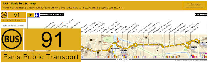
RATP Paris bus 91 map with stops, connections and route plan
Here you have the maps and timetables for the Paris bus line 91 that travels from Gare du Nord to Montparnasse 2 - Gare TGV and with numerous transport connections on route at places such as Republique and Gare de l'Est, it is actually the Gare de Lyon - Diderot bus stop you would need for getting to Bercy Arena, originally known as the POPB and now AccorHotels Arena.
Paris bus line 91 stops:
Montparnasse 2 - Gare TGV, Armorique - Musee Postal, Place de Catalogne, Gare Montparnasse, Montparnasse - Rue du Depart, Montparnasse, Montparnasse - Cinemas, Vavin, Campagne Premiere, Observatoire - Port Royal, Port Royal - Saint-Jacques, Port Royal - Berthollet, Les Gobelins, Saint-Marcel - Jeanne d'Arc, Saint-Marcel - La Pitie, Gare d'Austerlitz, Quai de la Rapee, Gare de Lyon - Diderot, Lyon - Ledru Rollin, Bastille, Bastille - Beaumarchais, Saint-Gilles - Chemin Vert, Saint-Claude, Oberkampf - Filles du Calvaire, Jean-Pierre Timbaud, Republique, Republique - Magenta, Jacques Bonsergent, Strasbourg - Magenta, Magenta - Saint-Martin, Gare de l'Est, Gare du Nord.
Paris bus line 91 main transport connections:
Metro Lines: 1, 2, 3, 4, 5, 6, 7, 8, 9, 10, 11, 12, 13, 14. Train Lines: A, B, C, D, E, H, K, N, P, R.
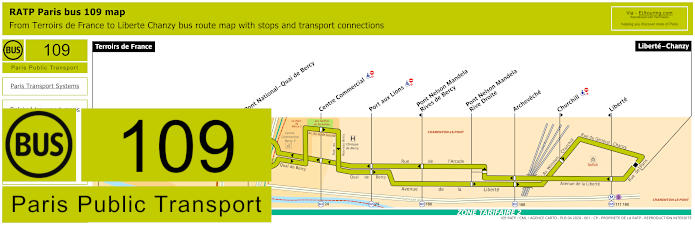
RATP Paris bus line 109 with stops, connections and street plan
Alternatively, you have the bus line 109 that travels from Liberte - Chanzy through to Terrors de France, which is the bus stop you would need for getting to AccorHotels Arena by walking through Bercy Village and the Parc de Bercy at a distance of approximately 1000 metres, and as you can see from the maps, with very few stops in between, this bus route travels from ticket tariff zone 2 to zone 1.
Paris bus line 109 stops:
Terroirs de France, Pont National - Quai de Bercy*, Centre Commercial, Port aux Lions, Pont Nelson Mandela - Rives de Bercy*, Pont Nelson Mandela - Rive Droite, Archeveche, Churchill**, Liberte*, Liberte - Chanzy.
* Stop served in direction of Terroirs de France. ** Stop served in direction of Liberte - Chanzy.
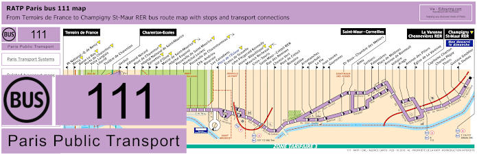
RATP Paris bus line 111 with stops, connections and street plan
Again, the RATP bus line 111 has a start an end point of Terroirs de France for getting to Bercy Arena, yet please do study the maps and timetables very careful as there are also other start and end points of Champigny St-Maur RER, La Varenne Chennevieres RER, Saint-Maur - Corneilles, Saint-Maur - Creteil RER, Place de l'Ecluse and Charenton-Ecoles, so there are many bus stops not served at specific times or on specific days such as Sunday.
Paris bus line 111 stops:
Terroirs de France, Pont National - Quai de Bercy*, Bercy**, Baron Le Roy, Porte de Charenton, Felix Langlais, Liberte, Theatre de Charenton, Charenton-Ecoles, Verdun**, Edmond Nocard*, Pont de Charenton*, Hopital National de Saint-Maurice**, Epinettes**, Val d’Osne**, Mairie de Saint-Maurice, Hopital Esquirol, Passerelle de Saint-Maurice, Marachel Leclerc, Passerelle de Charentonneau, CFA - Andrieu, Roseraie, Les Canadiens, Place de l'Ecluse*, Ecoles de Gravelle, John Fitzgerald Kennedy, Voisin - Republique, Maurice Berteaux, Croix - Souris, Saint-Maur - Creteil RER, Rue des Remises, Chemin Vert**, Pont de Creteil, Beaujeu, Galilee, Arromanches**, Bourbaki*, La Pie**, Jean Jaures**, Guynemer*, Dr Roux - Chambre des Metiers, Saint-Maur - Corneilles, Alma, Sorbiers, Falonnieres**, Place de Molenes, Avenue de Bonneuil, Voltaire, Arago*, Avenue des Piliers*, Eglise de La Varenne**, La Varenne - Chennevieres RER, Capitaine Charton***, Charles Peguy***, Thiers***, Gustave Goublier***, A. Dumas* ***, Champigny St-Maur RER.
* Stop served in direction of Terroirs de France. ** Stop served in direction of La Varenne Chennevieres RER or Champigny St-Maur RER. *** Not served on a Sunday.
Paris bus line 111 main transport connections:
Metro Lines: 8, 14. Train Line: A. Bus Lines: 7, 8, 24, 107, 109, 112, 116, 117, 180, 208abs, 306, 325, TVM (14).
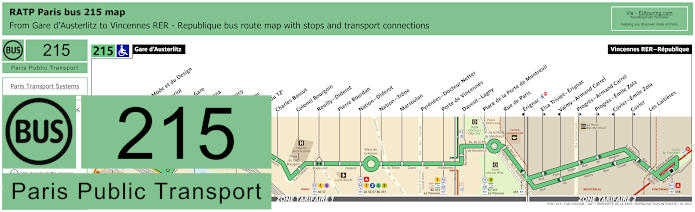
RATP Paris bus 215 map with stops, connections and street plan
Whereas this shows the maps and timetables for bus line 215 that travels between Gare d'Austerlitz and Vincennes RER - Republique with stops on route that have transport connections like Nation - Diderot and Place de la Porte de Montreil, and as you can see from the maps and timetables the closest stop to this impressive sports and entertainment venue, now called AccorHotels Arena, is the Bercy - Arena bus stop only a few metres from the entrance.
Paris bus line 215 stops:
Gare d'Austerlitz, Cite de la Mode et du Design, Vincent Auriol, Quai de la Gare, Bercy - Arena, Gare de Bercy, Dugommier, Mairie du 12e, Charles Bossut, Colonel Bourgoin, Reuilly - Diderot, Pierre Bourdan, Nation - Diderot, Nation - Trone, Marsoulan, Pyrenees - Docteur Netter, Porte de Vincennes, Davout - Lagny, Place de la Porte de Montreuil, Rue de Paris, Erignac*, Elsa Triolet - Erignac**, Valmy - Armand Carrel*, Progres - Armand Carrel**, Progres - Emile Zola**, Cuvier - Emile Zola*, Cuvier**, Les Laitieres, Vincennes RER - Republique.
* Stop served in direction of Gare d'Austerlitz. ** Stop served in direction of Vincennes RER - Republique.
Paris bus line 215 main transport connections:
Metro Lines: 1, 2, 5, 6, 8, 9, 10, 14. Train Lines: A, C. Tram Lines: T3a, T3b. Bus Lines: 24, 26, 46, 56, 57, 61, 63, 71, 77, 86, 87, 89, 91, 318, 325, 351, La Traverse (518).
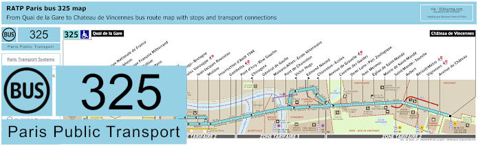
RATP Paris bus 325 map with stops, connections and street plan
However, these maps and timetables show the Paris bus line 325 that travels between the medieval castle of Chateau de Vincennes and Quai de la Gare close to the Bibliotheque Francois Mitterrand, and it is this latter terminus of Quai de la Gare that is within easy walking distance to Bercy Arena by walking over the bridge called the Pont de Bercy.
Paris bus line 325 stops:
Quai de la Gare, Bibliotheque Nationale de France, Emile Durkheim*, Bibliotheque Francois Mitterrand**, Pont de Tolbiac, Thomas Mann, Watt, Bruneseau, Victor Hugo - Bretagne, Jules Vanzuppe, Jean-Jacques Rousseau, Moliere, Insurrection d’Aout 1944, Gambetta, Pont d’Ivry - Rive Gauche, Chinagora*, General de Gaulle, Maisons-Alfort - Ecole Veterinaire, Pont de Charenton, Victor Hugo*, Edmond Nocard**, Charenton - Ecoles*, Avenue de Gravelle, Caserne des Gardes, Demi Lune - Parc Zoologique, Jean Mermoz, Eglise de Saint-Mande, Mairie de Saint-Mande, Saint-Mande - Tourelle, Aubert, Berault-Metro, Vignerons, Avenue du Chateau, Chateau de Vincennes.
* Stop served in direction of Quai de la Gare. ** Stop served in direction of Chateau de Vincennes.
Paris bus line 325 main transport connections:
Metro Lines: 1, 6, 8, 14. Train Lines: A, C. Bus Lines: 24, 25, 46, 56, 62, 64, 71, 86, 89, 103, 104, 107, 111, 112, 114, 115, 118, 124, 125, 132, 180, 181, 210, 318.
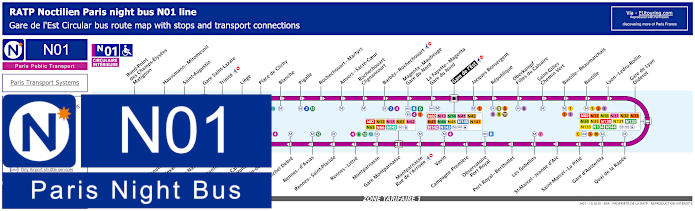
Paris Noctilien night bus N01 map with stops and transport connections
The Paris Noctilien is a night bus service that takes over when other public transport stops for the night, and here you can see the Noctilien N01 bus route, which is classed as the Circulaire Interieure, that travels in a complete circuit from Gare de l'Est and is a way for how to get to Gare Montparnasse train station and many other stops that have transport connections including Gare de Lyon - Diderot for Bercy Arena.
Paris night bus line N01 stops:
Gare de l'Est, Jacques Bonsergent, Republique, Oberkampf - Filles du Calvaire, Saint-Gilles - Chemin Vert, Bastille - Beaumarchais, Bastille, Lyon - Ledru-Rollin, Gare de Lyon - Diderot, Quai de la Rapee, Gare d'Austerlitz, Saint-Marcel - La Pitie, Saint-Marcel - Jeanne d'Arc, Les Gobelins, Port Royal - Berthollet, Observatoire - Port Royal, Campagne Premiere, Vavin, Montparnasse - Rue de l'Arrivee, Gare Montparnasse, Montparnasse, Rennes - Littre, Rennes - Saint-Placide, Rennes - d'Assas, Michel Debre, St-Germain-des-Pres, Pont du Carrousel - Quai Voltaire, Henry de Montherlant, Assemblee Nationale, Pont Alexandre III, Palais de la Decouverte, Rond-Point des Champs-Elysees - Matignon, Haussmann - Miromesnil, Saint-Augustin, Gare Saint-Lazare, Trinite, Liege, Place de Clichy, Blanche, Pigalle, Rochechouart - Martyrs, Anvers - Sacre-Coeur, Rochechouart - Clignancourt, Barbes - Rochechouart, Magenta - Mauberge - Gare du Nord, La Fayette - Magenta - Gare du Nord, Gare de l'Est.
Paris night bus line N01 main transport connections:
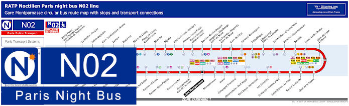
Paris Noctilien night bus N02 map with stops and transport connections
Yet this is another night bus that runs in a complete circuit and called the Circulaire Exterieure, the Noctilien N02 bus line goes from Gare Montparnasse and has stops such as Place de Clichy for getting to Casino de Paris along with night bus stops for other entertainment venues like Gare de Lyon - Diderot for Bercy Arena and Bastille for the Opera Bastille, etc.
Paris night bus line N02 stops:
Gare Montparnasse, Montparnasse, Vavin, Campagne Premiere, Observatoire - Port Royal, Port Royal - Berthollet, Les Gobelins, Saint-Marcel - Jeanne d'Arc, Saint-Marcel - La Pitie, Gare d'Austerlitz, Quai de la Rapee, Gare de Lyon - Diderot, Lyon - Ledru-Rollin, Bastille, Bastille - Beaumarchais, Saint-Gilles - Chemin Vert, Oberkampf - Filles du Calvaire, Republique, Jacques Bonsergent, Gare de l'Est, La Fayette - Magenta - Gare du Nord, Magenta - Maubeuge - Gare du Nord, Barbes - Rochechouart, Rochechouart - Clignancourt, Anvers - Sacre-Coeur, Rochechouart - Martyrs, Pigalle, Blanche, Place de Clichy - Caulaincourt, Place de Clichy, Bucarest, Europe, Gare Saint-Lazare - Rome, Saint-Augustin, La Boetie - Percier, Rond-Point des Champs-Elysees - Franklin D. Roosevelt, Palais de la Decouverte, Pont Alexandre III, Assemblee Nationale, Solferino - Bellechasse, Saint-Guillaume, Saint-Germain-des-Pres, Michel Debre, Rennes - d'Assas, Rennes - Saint-Placide, Rennes - Little, Montparnasse - Rue de l'Arrivee, Gare Montparnasse.
Paris night bus line N02 main transport connections:
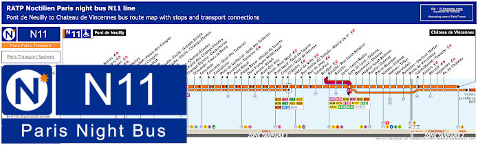
Paris Noctilien night bus N11 map with stops and transport connections
As you will see from the maps and timetables the Noctilien night bus line N11 travels between Pont de Neuilly and Chateau de Vincennes, and this is one of the options for how to get to Palais des Congres along with getting to Le Duc des Lombards Jazz Club via the Chatelet stop and many other entertainment venues including being within walking distance of Bercy Arena via the Gare de Lyon - Diderot stop.
Paris night bus line N11 stops:
Pont de Neuilly, Maurice Barres, Les Graviers, Les Sablons, Marche, Andre Maurois*, Porte Maillot - Palais des Congres*, Palais des Congres**, Porte Maillot**, Argentine, Charles de Gaulle - Etoile - Grande Armee, Charles de Gaulle - Etoile - Champs-Elysees, George V, La Boetie - Champs-Elysees, Rond-Point des Champs-Elysees, Champs-Elysees - Clemenceau, Concorde - Cours la Reine, Concorde*, Concorde - Quai des Tuileries**, Castiglione*, Pont de Solferino - Quai des Tuileries**, Pyramides - Tuileries*, Pont Royal**, Palais Royal - Musee du Louvre*, Quai Francois Mitterrand**, Louvre - Rivoli*, Pont des Arts**, Rivoli - Pont Neuf*, Pont Neuf - Quai du Louvre**, Chatelet - Quai de Gesvres**, Chatelet*, Hotel de Ville, Rue Vieille du Temple - Mairie du 4e*, Rue de Jouy**, Saint-Paul, Birague, Bastille - Rue Saint-Antoine, Bastille, Lyon - Ledru-Rollin, Gare de Lyon - Diderot, Daumesnil - Diderot, Hopital Saint-Antoine, Reuilly - Diderot, Pierre Bourdan, Nation - Diderot, Nation - Trone, Marsoulan, Pyrenees - Docteur Netter, Porte de Vincennes, Saint-Mande - Tourelle**, Aubert, Berault, Vignerons, Avenue du Chateau, Chateau de Vincennes.
* In direction of Pont de Neuilly. ** In direction of Chateau de Vincennes.
Paris night bus line N11 main transport connections:
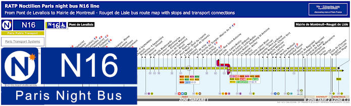
Paris Noctilien night bus N16 map with stops and transport connections
Whereas the Noctilien N16 line travels between Pont de Levallois and Mairie de Montreuil - Rouget de Lisle and just like the Noctilien lines above, you would need the Gare de Lyon - Diderot night bus stop for getting to Bercy Arena, yet this is also an option for other entertainment venues like getting to the Olympia Paris, or Olympia Bruno Coquatrix as it is also called, via the Auber stop.
Paris night bus line N16 stops:
Pont de Levallois, Picasso*, Vaillant - Couturier*, Anatole France**, Mairie de Levallois*, Porte de Courcelles*, Porte de Champerret, Pereire - Le Chatelier*, Pereire - Villiers**, Europe, Gare Saint-Lazare - Rome**, Gare Saint-Lazare, Rome - Haussmann*, Havre - Haussmann**, Auber, Opera, Opera - 4 Septembre**, Choiseul*, Richelieu - 4 Septembre**, Richelieu - Drouot*, Bourse**, Grands Boulevards*, Reaumur - Montmartre, Louvre - Etienne Marcel, Bourse de Commerce, Louvre - Rivoli, Rivoli - Pont Neuf*, Pont Neuf - Quai du Louvre**, Chatelet - Quai de Gesvres**, Chatelet*, Hotel de Ville, Rue Vieille du Temple - Mairie du 4e*, Rue de Jouy**, Saint-Paul, Birague, Bastille - Rue Saint-Antoine, Bastille, Lyon - Ledru-Rollin, Gare de Lyon - Diderot, Daumesnil - Ledru-Rollin, Ledru-Rollin - Faubourg St-Antoine, Charonne - Keller, Basfroi, Voltaire - Leon Blum, Saint-Maur - Servan, Roquette - Pere Lachaise, Folie Regnault - Chemin Vert*, Auguste Metivier*, Pere Lachaise**, Muriers*, Martin Nadaud*, Gambetta*, Hopital Tenon*, Pelleport, Porte de Bagnolet, Echangeur de Bagnolet**, General de Gaulle, Republique - Robespierre, Fraternite, Sorins, Marche, Croix de Chavaux - Rouget de Lisle, Victor Hugo, Mairie de Montreuil - Rouget de Lisle.
* Served in direction of Pont de Levallois. ** Served in direction of Mairie de Montreuil - Rouget de Lisle.
Paris night bus line N16 main transport connections:
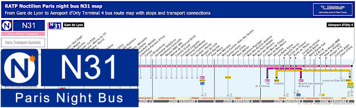
Paris Noctilien night bus N31 map with stops and transport connections
If you are having to fly out of Paris late at night after having been to a sports event or show, such as one of those at Bercy Arena, then you will be pleased to know that the Noctilien N31 night bus line starts at Gare de Lyon and is an option for how to get to Orly Airport as its terminus is Aeroport d'Orly - Terminal 4 and within the terminal you can get airport shuttles to Orly 1-2-3.
Paris night bus line N31 stops:
Gare de Lyon, Gare de Lyon - Van Gogh, Quai de la Rapee, Gare d'Austerlitz, Saint-Marcel - La Pitie, Place d'Italie - Mairie du 13e, Place d'Italie - Auriol, Nationale, Clisson, Patay - Tolbiac, Oudine, Porte de Vitry, Chateau des Rentiers**, Port d'Ivry**, Port d'Ivry - Massena*, Porte de Choisy, Chateaudun - Barbes, Cimetiere Parisien d'Ivry, Carnot, La Briqueterie, Germaine Tailleferre, Beethoven Concorde, Musee MAC VAL, Mairie de Vitry-sur-Seine, Camille Groult, Constant Coquelin, Watteau Rondenay, Trois Communes, Verdun - Hoche, Rouget de Lisle, Carle Darthe, Four Peary, Jean Mermoz, Marcel Cachin - Voie des Saules, Gaston Viens, Mairie d'Orly, Parc Melies, Cimetiere Paysager, Rue des Quinze Arpents, Rue du Puits Dixme, Rue des Oliviers, Centre Bus de Thiais, Rue du Bas Marin, Alouettes, La Belle Epine, Auguste Perret**, Le Cor de Chasse*, Porte de Thiais*, Le Cor de Chasse - La Belle Epine**, Belle Epine Sud, S.E.N.I.A., Pont de Rungis RER**, Pont de Rungis*, Hangar No 6, Caroline Aigle, Coeur d'Orly, Aeroport d'Orly - Terminal 4.
* Bus stop served in direction of Aeroport d'Orly 4. ** Bus stop served in direction of Gare de Lyon.
Paris night bus line N31 main transport connections:
Metro Lines: 1, 5, 6, 7, 10, 14. Train Lines: A, C, D, R. Tram Lines: T3a, T7, T9. Bus Lines: N01, N02, N11, N16, N22, N32, N33, N34, N35, N71, N130, N131, N132, N133, N134, N144, TVM (14).
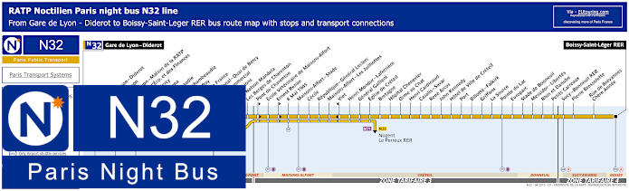
Paris Noctilien night bus N32 map with stops and transport connections
Here you can see the maps and timetables for the night bus line N32, which travels between Gare de Lyon - Diderot and Boissy-Saint-Leger RER and as you can see, there is a Noctilien bus stop called Bercy - Arena, which is very close to AccorHotels Arena, but please take not of the different ticket tariff zones that you may travel through not forgetting certain stops that are direction dependant.
Paris night bus line N32 stops:
Gare de Lyon - Diderot, Gare de Lyon - Diderot**, Gare de Lyon*, Gare de Lyon - Maison de la RATP**, Minis. de l'Eco. et des Finances, Gare de Bercy*, Bercy - Arena, Lachambeaudie*, Dijon - Lachambeaudie**, Baron Le Roy, Terroirs de France, Pont National - Quai de Bercy*, Centre Commercial*, Port aux Lions, Pont Nelson Mandela, Les Berges de Charenton, Pont de Charenton**, Ecole Veterinaire de Maisons-Alfort, Ernest Renan**, 8 Mai 1945, Maisons-Alfort - Stade, Cecile, Republique - General Leclerc, Maisons-Alfort - Les Juilliottes, Viet*, Henri Mondor - Laferriere, General Gallieni, Eglise de Creteil, Bretagne, Hopital Chenevier, Orme au Chat, Henri Cardinaud, Casalis - Savar, Rene Arcos, John Kennedy, Hotel de Ville de Creteil, Port, Billotte - Falkirk, Griffons, La Source, Pointe du Lac, Europarc, Stade de Bonneuil, Messidor - Libertes, Rhin et Danube, Petits Carreaux, Sucy - Bonneuil RER, Pierre Brossolette, Rue de Brevannes - Chere Annee, Boissy-Saint-Leger RER.
* Stop served in direction of Gare de Lyon - Diderot. ** Stop served in direction of Boissy-Saint-Leger RER.
Paris night bus line N32 main transport connections:
Metro Lines: 1, 6, 8, 14. Train Lines: A, D, R. Bus Lines: N01, N02, N11, N16, N31, N33, N34, N35, N71, N130, N131, N132, N133, N134, N144.
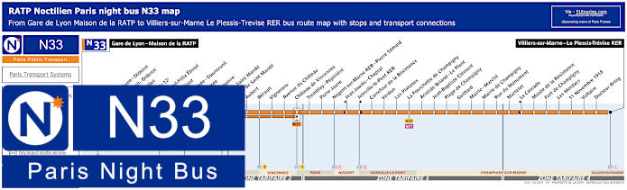
Paris Noctilien night bus N33 map with stops and transport connections
Yet travelling between Villiers-sur-Marne - Le Plessis-Trevise RER and Gare de Lyon - Maison de la RATP, which is the stop you would need for Bercy Arena, as you can see from the Noctilien N33 maps and timetables, this night bus route travels through different communes, or areas of the Paris region including Vincennes, Nogent and Joinville-le-Pont, etc.
Paris night bus line N33 stops:
Gare de Lyon - Maison de la RATP, Gare de Lyon - Diderot, Daumesnil - Diderot*, Rambouillet, Mairie du 12e, Daumesnil - Felix Eboue, Michel Bizot, Porte Doree - Daumesnil*, Porte Doree**, Montempoivre, Porte de Saint Mande, Mairie de Saint Mande, Aubert, Berault, Vignerons, Avenue du Chateau, Chateau de Vincennes, Tremblay - Pepiniere, Porte Jaune, Nogent-sur-Marne RER - Pierre Semard, Jean Jaures - Chapsal*, Joinville-le-Pont RER**, Carrefour de la Resistance, Verdun, Les Platanes, La Fourchette de Champigny, Aristide Briand - Le Plant, Jean-Baptiste Clement, Plage de Champigny, Guittard, Mairie - Marche, Mairie de Champigny, Rue du Monument, Martelet, La Cascade*, Musee de la Resistance, Fort de Champigny, Les Mordacs, 11 Novembre 1918, Voltaire, Docteur Bring, Villiers-sur-Marne - Le Plessis-Trevise RER.
* Stop served in direction of Gare de Lyon - Maison de la RATP. ** Stop served in direction of Villiers-sur-Marne - Le Plessis-Trevise RER.
Paris night bus line N33 main transport connections:
Metro Lines: 1, 6, 8, 14. Train Lines: A, D, E, R. Tram Line: T3a. Bus Lines: N01, N02, N11, N16, N31, N32, N34, N35, N71, N130, N131, N132, N133, N134, N144.
Paris Noctilien night bus N34 map with stops and transport connections
Here you have another night bus within walking distance of Bercy Arena that you could utilise after a concert or sports event, as the Noctilien N34 route goes from Gare de Lyon - Diderot through to Torcy RER, which stops at many other train stations on route as it goes through different communes to the outskirts of the Paris region, Ile de France.
Paris night bus line N34 stops:
Gare de Lyon - Diderot, Gare de Lyon - Maison de la RATP, Gare de Lyon - Diderot, Daumesnil - Ledru-Rollin, Ledru-Rollin - Faubourg Saint-Antoine, Charonne - Keller, Basfroi, Voltaire - Leon Blum, Saint-Maur - Servan, Roguette - Pere Lachaise, Folie-Regnault - Chemin Vert, Auguste Metivier, Pere Lachaise, Muriers, Martin Nadaud, Gambetta, Hopital Tenon, Pelleport, Porte de Bagnolet, Echangeur de Bagnolet, General de Gaulle, Republique - Robespierre, Fraternite, Sorins, Marche, Croix de Chavaux - Rouget de Lisle, Victor Hugo, Mairie de Montreuil - Rouget de Lisle, Mairie de Montreuil, Centre Administratif, Lycee Jean Jaures, Danton, Edouard Branly, Nouvelle France, Acacia, Fort de Rosny, Saint-Exupery, Babeuf, Charles Delavacquerie, Le Morillon, Jules Guesde, Cimetiere de Vincennes, La Fontaine, Jean Mace, Pablo Picasso, Val de Fontenay RER, Val de Fontenay RER - Louison Bobet, Croix d'Eau, Avron, Jules Ferry, Jouleau, Neuilly-Plaisance RER, Centre Bus, Helene Boucher, Villebois - Mareuil, Foch - De Gaulle, Place de la Resistance, Rene Navier, Route de Neuilly, Noisy-le-Grand - Mont d'Est RER, Republique, Espace Michel Simon, Mairie de Noisy-le-Grand, Carrefour de Malnoue, Pointe de Gournay, Les Prevoyants, Les Rosiers, Place Churchill, Rond-Point des Pyramides, C.S.T.B. - Matteotti, Les Iris, Pointe de Champs, Mairie de Champs, Maison de Retraite, Les Quatre Paves, Jules Ferry, La Remise aux Fraises, Cite Scolaire, La Mogotte, Bel Air, Les Tilleuls, Mairie de Torcy, La Mare aux Marchais, Rue des Epinettes, Jacques Prevert, Rives de Maubuee, Salvador Allende, Cites Unies, Torcy RER.
Paris night bus line N34 main transport connections:
Metro Lines: 1, 2, 3, 3bis, 8, 9, 14. Train Lines: A, D, E, R. Tram Line: T3b. Bus Lines: N01, N02, N11, N16, N31, N32, N33, N35, N71, N130, N131, N132, N133, N134, N141, N142, N144.
Paris Noctilien night bus N35 map with stops and transport connections
Again, the Noctilien N35 night bus line goes from Gare de Lyon - Diderot travelling through to Villiers sur Marne - Le Plessis Trevise RER, but as you can see from the maps and timetables, you also have the Gare de Bercy train station night bus stop that you could utilise as well, and just like many other routes this goes from Paris through different communes including Maisons-Alfort, Joinville and Champigny-sur-Marne within the Paris region.
Paris night bus line N35 stops:
Gare de Lyon - Diderot, Gare de Lyon - Diderot*, Gare de Lyon**, Gare de Lyon - Maison de la RATP*, Minis. de l’Economie et des Finances, Gare de Bercy, Dugommier, Charenton - Jardiniers*, Porte de Charenton, Felix Langlais, Liberte - Metro, Theatre de Charenton, Charenton - Ecoles, Victor Hugo**, Pont de Charenton*, Ecole Veterinaire de Maisons-Alfort, Ernest Renan*, 8 Mai 1945**, Gabriel Peri, Rene Coty, Rue de Vincennes, Lyon, Voisin - Republique, Maurice Berteaux, Liberation - Rabelais*, Marinville, Liberation - Conde, Bourgogne, Cimetiere, Neptune, Anatole France - Pierre Brossolette*, Champigny - Saint-Maur RER, Marche, Mairie de Champigny - Marche**, Mairie de Champigny, Rue du Monument, Martelet, La Cascade**, Musee de la Resistance, Fort de Champigny, Avenue Georges, R. des Fusilles de Chateaubriant, Groupe Scolaire Rousseau, College Boileau, Bois l'Abbe, Veterans, Fauvettes, Colombe - Hardelet, Rue du Bois l'Abbe - L. Collet, Docteur Bring, Villiers sur Marne - Le Plessis Trevise RER.
* In direction of Villiers sur Marne - Le Plessis Trevise RER. ** In direction of Gare de Lyon - Diderot.
Paris night bus line N35 main transport connections:
Metro Lines: 1, 6, 8, 14. Train Lines: A, D, E, R. Tram Line: T3a. Bus Lines: N01, N02, N11, N16, N31, N32, N33, N34, N71, N130, N131, N132, N133, N134, N142, N144.
Paris Noctilien night bus N130 map with stops and transport connections
So here you have the maps and timetables for the Noctilien night bus line N130 that travels from Gare de Lyon - Van Gogh stop on the Rue de Bercy going through to Marne-la-Vallee - Chessy, Gare Routiere, and you will see Gare Routiere mentioned on a few stops, which actually means Bus Station in English. But for leaving the AccorHotels Arena, or Bercy Arena, you would need the start point by Gare de Lyon train station.
Paris night bus line N130 stops:
Gare de Lyon - Van Gogh - Rue de Bercy, Ministere de l'Economie et des Finances - Rue de Bercy, Terroirs de France - Avenue des Terroirs de France, Parc du Tremblay - Boulevard de Stalingrad, Fourchette de Bry - Avenue du General de Gaulle, Beausejour - Rue Jean Jaures, Gare Villiers sur Marne - Le Plessis Trevise - Rue du Chemin de Fer, Georges Demesy - Avenue Andre Rouy*, Avenue de Gaumont - Rue du General de Gaulle*, Friedberg - Boulevard de Friedberg, Gare Noisy le Grand - Mont d'Est - Gare routiere, Gare Noisy Champs RER - Descartes - Boulevard Archimede, Noisel le Luzard RER - Allee Jean Paul Sartre, Cours des Lacs - Cours du Buisson*, Cours des Lacs - Place Charles Cros**, College Jean Monnet - Cours des Lacs, College du Segrais - Boulevard du Segrais, Torcy RER - Gare routiere, Collegien - Rue de Melun, Gare de Bussy St-Georges - Gare routiere, Gare de Val d'Europe - Serris Montevrain - Gare routiere, Marne-le-Vallee - Chessy - Gare routiere Nord.
* Stops in the direction of Marne-la-Vallee Chessy Gare routiere. ** Stops in the direction of Gare de Lyon - Van Gogh - Rue de Bercy.
Paris night bus line N130 main transport connections:
Metro lines: 1, 14. Tran lines: A, D, R. Bus lines: N01, N02, N11, N16, N31, N32, N33, N34, N35, N131, N132, N133, N134, N144.
Paris Noctilien night bus N131 map with stops and transport connections
The Noctilien line N131 also starts at Gare den Lyon on the Rue de Bercy and travels through to Gare de Bretigny sur Orge, and as you can see from the maps and timetables, there is more than one night bus stop you could utilise when getting from Bercy Arena including the Gare d'Austerlitz or Quai de la Gare stops, but please note that some stops are direction dependant and Orly Airport changed its name from Orly Sud and Orly West to Orly 1-2-3 and Orly 4.
Paris night bus line N131 stops:
Paris Gare de Lyon - Van Gogh - Rue de Bercy, Gare d'Austerlitz - Quai d'Austerlitz*, Gare d'Austerlitz - Avenue Piere Mendes France**, Quai de la Gare - Quai de la Gare, Bibliotheque Chevaleret - Rue de Tolbiac, Airport Orly 4 - Quai 4, Airport Orly 1-2-3 - Quai 8, Aristide Briand - Avenue de Fontainebleau, Pyramide de Juvisy - Avenue Francois Mitterrand**, Pyramide de Juvisy - Avenue de la Cour de France*, Mairie de Juvisy - Avenue de la Cour de France, Gare de Juvisy - Rue du Marechal Juin, Blazy - Avenue du General De Gaulle, Savigny sur Orge RER - Place de la Gare*, Savigny sur Orge RER - Place de la Gare**, Gare d'Epinay sur Orge - Rue de Corbeil, Gare de Ste-Genevieve-des-Bois - Place du President Roosevelt, Gare de St-Michel-sur-Orge - Place de la Gare, Gare de Bretigny Sur Orge - Gare routiere - Place Pierre Vennin.
* In direction of Gare de Bretigny-sur-Orge - Gare routiere - Place Pierre Vennin. ** In direction of Paris Gare de Lyon - Van Gogh - Rue de Bercy.
Paris night bus line N131 main transport connections:
Metro lines: 1, 14. Train lines: A, D, R. Tram line: T7. Bus lines: N01, N02, N11, N16, N22, N31, N32, N33, N34, N35, N130, N132, N133, N134, N135, N144, Plus Orly Airport transport connections.
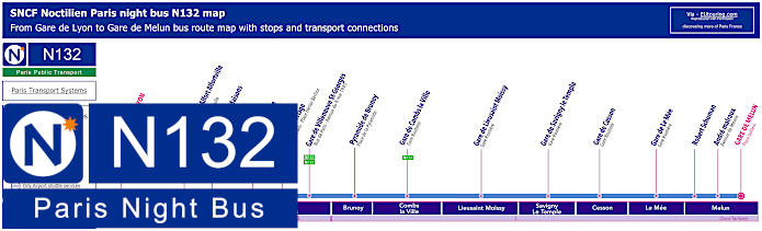
Paris Noctilien night bus N132 map with stops and transport connections
Yet another night bus, Noctilien line N132, also goes from Paris Gare de Lyon and travels through to Melun, passing through numerous communes, or areas, on its journey from Paris including Brunoy, Combs la Ville, Savigny Le Temple and Cesson in ticket tariff zone 5 as you can see from the night bus maps and timetables.
Paris night bus line N132 stops:
Paris Gare de Lyon - Van Gogh - Rue de Bercy, Gare de Maisons Alfort Alfortville - Avenue du General De Gaulle, Gare du Vert de Maisons - Rue Jean Jaures, Villeneuve Prairie - Avenue Henri Barbusse, Villeneuve Triage - Rue de Paris - Place Hector Berlioz, Gare de Villeneuve St-Georges - Rue de Paris - Avenue du 8 Mai 1945, Pyramide de Brunoy - Place de la Pyramide, Gare de Combs-la-Ville - Gare Routiere, Gare de Lieusaint Moissy - Gare Routiere, Gare de Savigny-le-Temple - Gare Routiere, Gare de Cesson - Gare Routiere, Gare de Le Mee - Gare Routiere, Robert Schuman, Andre Malraux - Avenue de Meaux, Gare de Melun - Place Gallieni.
* Night bus stop served in direction of Melun. ** Night bus stop served in direction of Paris Gare de Lyon.
Paris night bus line N132 main transport connections:
Metro lines: 1, 14. Train lines: A, D, R. Bus lines: N01, N02, N11, N16, N31, N32, N33, N34, N35, N130, N131, N133, N134, N135, N144.
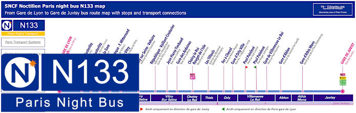
Paris Noctilien night bus N133 map with stops and transport connections
However, this shows the maps and timetables for the Noctilien night bus line N133 that goes from Paris Gare de Lyon to Gare de Juvisy, and as well as the main train station you could also utilise the Gare d'Austerlitz or Quai de la Gare bus stops when leaving the Bercy Arena after enjoying one of their many events.
Paris night bus line N133 stops:
Paris Gare de Lyon - Van Gogh - Rue de Bercy, Gare d'Austerlitz - Quai d'Austerlitz*, Gare d'Austerlitz - Avenue Pierre Mendes France**, Quai de la Gare - Quai de la Gare, Bibliotheque - Chevaleret - Rue de Tolbiac, Porte de Vitry - Avenue de la Porte de Vitry, Ivry sur Seine - Voltaire - Avenue Danielle Casanova, Republique - Vaillant Couturier - Gare de Vitry sur Seine - Avenue de la Republique, Jean Pierre Timbaud - Rue Leon Geffroy, Gare des Ardoines - Rue Leon Geffroy, Choisy le Roi - Rouget de l'Isle - Boulevard des Allies, Les Tilleuls - Avenue du Marechal Delattre de Tassigny, Fer a Cheval - Avenue Adrien Raynal, Gare d'Orly Ville - Rue du 11 Novembre 1918, Paul Painleve - Avenue Sadi Carnot*, Paul Painleve - Rue Roger Salengro**, Gare de Villeneuve Le Roi - Avenue Paul Doumer, Gare d'Ablon - Avenue du General De Gaulle, Gare d'Athis Mons - Place Rothenburg, Gare de Juvisy - Rue des Gaublois.
* Night bus stop served in direction of Gare de Juvisy. ** Night bus stop served in direction of Paris Gare de Lyon.
Paris night bus line N133 main transport connections:
Metro lines: 1, 14. Train lines: A, C, D, R. Bus lines: N01, N02, N11, N16, N31, N32, N33, N34, N35, N71, N130, N131, N132, N134, N135, N144.
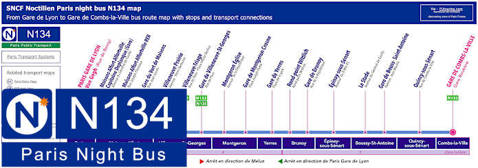
Paris Noctilien night bus N134 map with stops and transport connections
Whereas the Noctilien N134 night bus line travels from Paris Gare de Lyon - Van Gogh on the Rue de Bercy through to Gare de Combe la Ville - Gare Routiere, stopping at many train stations on route, some of which have transport connections to other Noctilien lines such as the Gare du Vert de Maisons and the Gare de Villeneuve St-Georges, which is another option for AccorHotels Arena and Parc de Bercy.
Paris night bus line N134 stops:
Paris Gare de Lyon - Van Gogh - Rue de Bercy, Gare de Maisons Alfort Alfortville - Capitaine Deplanque (Gare) - Avenue du General de Gaulle*, Maisons-Alfort Alfortville RER - Rue Jospeh Fleutiaux*, Gare du Vert de Maisons - Rue Jean Jaures, Villeneuve Prairie - Avenue Henri Barbusse, Villeneuve Triage - Rue de Paris - Place Henri Berlioz, Gare de Villeneuve-St-Georges - Rue de Paris, Montgeron Eglise - Avenue de la Republique, Gare de Montgeron Crosne - Place Joseph Piette, Gare de Yerres - Place de la Gare, Rond-Point Wittlich - Ront-point Wittlich, Gare de Brunoy - Rue de la Republique, Epinay-sous-Senart - Avenue du 8 Mai 1945, Le Stade - Avenue du General de Gaulle, Gare de Boussy-Saint-Antoine - Avenue Jean Moulin, Quincy-sous-Senart - Rue de Combs-la-Ville, Gare de Combs-la-Ville - Gare Routiere.
* Bus stop only served in one direction.
Paris night bus line N134 main ransport connections:
Metro lines: 1, 14. Train lines: A, D, R. Bus lines: N01, N02, N11, N16, N31, N32, N33, N34, N35, N130, N131, N132, N133, N135, N144.
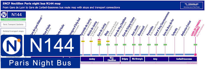
Paris Noctilien night bus N144 map with stops and transport connections
In addition, you also have the Noctilien N144 night bus line that now goes from Gare de Lyon - Diderot on the Rue de Lyon, so as you will see from the maps and timetables, if you required Gare de l'Est train station you would need to get the Noctilien N01 or N02 routes, yet the N144 journey also goes to Aerogare d'Orly Sud now called Orly 4, and for Bercy Arena you would need the start point of Gare de Lyon travelling in the direction of Gare de Corbeil-Essonnes.
Paris night bus line N144 stops:
Gare de Lyon - Diderot - Rue de Lyon*, Place d'Italie - Place d'Italie, Porte d'Italie, Airport Orly 4 - Quai 4, Pyramide de Juvisy - Avenue F. Mitterrand***, Pyramide de Juvisy - Avenue de la Cour de France**, Mairie de Juvisy - Avenue de la Cour de France - Avenue F. Mitterrand, Gare de Juvisy - Place du Marechal Joffre, Blazy - Avenue du General de Gaulle, Gare de Viry-Chatillon - Avenue du General de Gaulle, Gare de Grigny Centre - Route de Grigny (Centre Cial), Jean Jaures - Route de Grigny, Daumesnil - Avenue de la Liberation, Pyramides - Boulevard des Champs-Elysees, Gare d'Evry Courcouronnes - Gare routiere basse d'Evry, Gare du Bras de Fer - Bd des Coquibus, Tarterets - Bd Jean Jaures, Ambroise Croizat - Boulevard Jean Jaures, Gare de Corbeil-Essonnes - Place Henri Barbusse.
* For Gare de l'Est change to the N01 or N02. ** Night bus stop served in direction of Corbeil-Essonnes. *** Night bus stop served in direction of Paris Gare de Lyon.
Paris night bus line N144 main transport connections:
Metro Lines: 1, 14. Train Lines: A, D, R, TGV. Bus Lines: N01, N02, N15, N22, N31, N32, N33, N34, N35, N130, N131, N132, N133, N134, N135, Plus Orly 4 Airport Transport Connections.
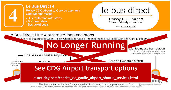
Le Bus Direct 4 Charles de Gaulle Airport to Gare Montparnasse map with stops, timetables and ticket information
But if you are thinking of how to get to Charles de Gaulle Airport after having been to an event at the AccorHotels Arena, formerly the POPB, then you will be pleased to know that there is a dedicated shuttle bus company called Le Bus Direct that offers this service, and classed as the Bus Direct 4 route, this starts at Gare Montparnasse, then goes to Gare de Lyon where it stops at 20 Boulevard Diderot, before travelling on to CDG Terminal 1 and CDG Terminals 2A to 2F.
CDG Airport Terminal 2E 2F, CDG Airport Terminal 2A 2C 2D, CDG Airport Terminal 1, Gare de Lyon, Gare Montparnasse.
Le Bus Direct 4 ticket pricing:
Adult ticket €18.00 one way or €31.00 return Child ticket (aged 4-11 years) €10.00 one way or €20.00 return Group (discount for +3 people) €13.00 pp one way or €26.00 pp return pricing is per person
Download Le Bus Direct 4 route map, timetables and ticket info:
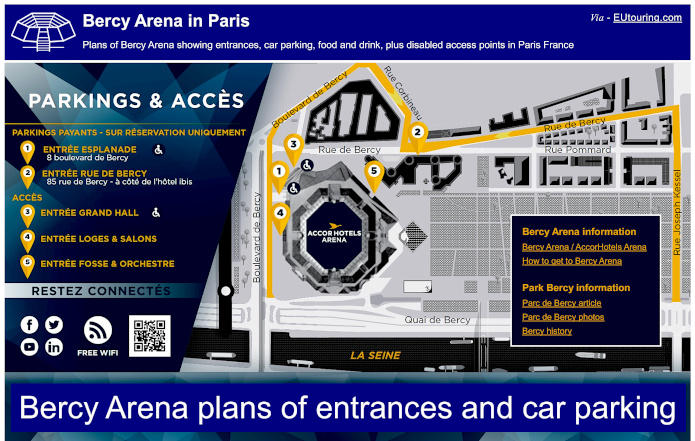
Bercy Arena plans of entrances and public services plus local area maps
Access plans for Bercy Arena with entrances, car parking, food & drink, plus disabled access points
Here you can see the plans for AccorHotels Arena, originally known as the POPB and this shows the car parks, which are only accessible via prior reservations with one suitable for the disabled, in addition to the various entrances to Bercy Arena, the wheelchair accessible Grand Hall entrance, not forgetting the dedicated Ice rink entrance and also the plan of the various ticket gates, bars, restaurants, snack stands, toilets and much more to make your visit run smoothly.
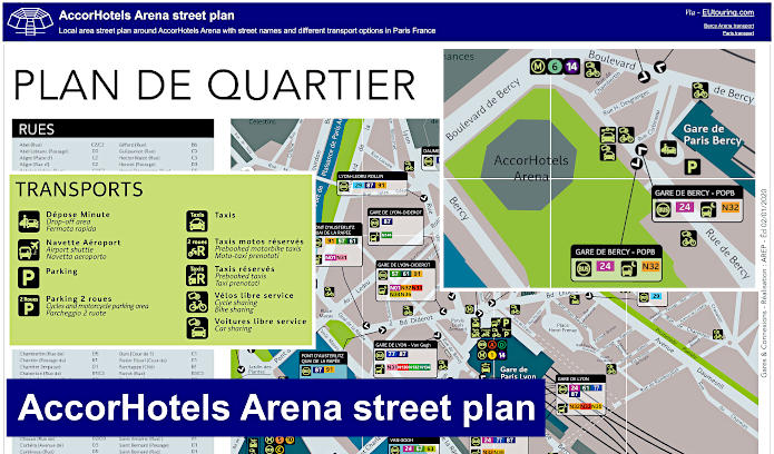
AccorHotels Arena area street plan with local transport options
Whereas here you can see the AccorHotels Arena street plans with the list of road names on the grid along with a rough guide to walking distances from this impressive sports and entertainment venue in Paris, which is one of the top arenas in the world, and these plans also show the location of public transport, Taxi ranks and more that can get you to or from this Paris events venue.
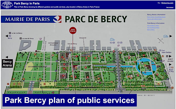
Plan of Park Bercy its gardens and public services, plus location of Bercy Arena
Yet here we have a plan of Parc de Bercy showing various things you can discover and enjoy within this little known but impressive Paris Park that borders on the POPB Bercy Arena, now called AccorHotels Arena, which is to the left and Bercy Village is to the right as you are looking at the map of this park produced by the Mayor of Paris.