How to get to Les Invalides in Paris using public transport
Below you will find the different transport options of how to get to Les Invalides including plans and information for the popular and historical tourist attraction, home to the Tomb of Napoleon and Army museum, along with public transport maps and timetables for RER, Metro, buses and Noctilien night buses in Paris, that still has many reminders of its past like the canons with its official name of Hotel des Invalides.
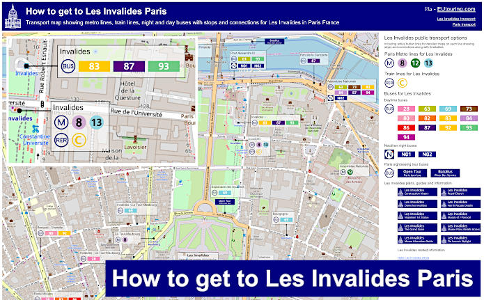
Les Invalides transport map of Metro lines, trains and bus lines with stops, connections and street plan
Now here you can see the street plan of the area surrounding the historical Les Invalides with its museums showing the various bus stops, the RER train station and the Metro stations, meaning you can get to different areas of Paris and its attractions or beyond.
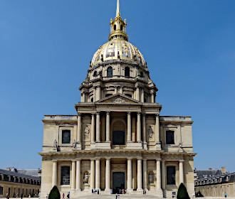
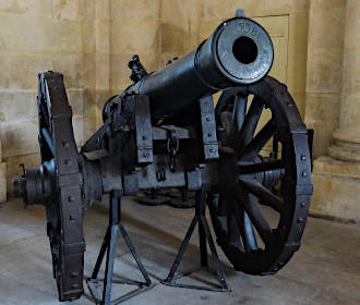
Just as a point of interest, the canons that stand central on the perimeter of Les Invalides are only fired to salute a newly-elected French President and actually face in the direction of the Elysee Palace. Yet if you are standing by the Place Vauban, you can get a fabulous view of the golden Eglise du Dome, which is home to the Tomb of Napoleon I.
How to get to Les Invalides public transport maps available:
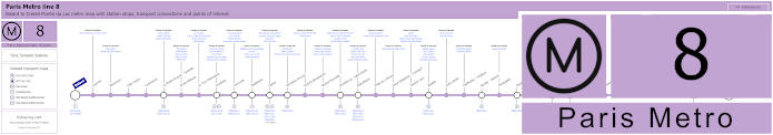
Paris Metro Line 8 map with stations, connections and points of interest
This map shows Paris Metro line 8 that goes from the Balard Metro station to Creteil - Pointe du Lac, which has stops on route by tourist attractions like the Ecole Militaire and Invalides, which are both a short walk from the Hotel des Invalides, and this line is also how to get to Bastille, Opera, Concorde, Madeleine, etc, not forgetting that some hubs like Republique provide many transport connections.
Metro line 8 stops:
Balard, Lourmel, Boucicaut, Felix Faure, Commerce, La Motte-Picquet - Grenelle, Ecole Militaire, La Tour-Maubourg, Invalides, Concorde, Madeleine, Opera, Richelieu-Drouot, Grands Boulevards, Bonne Nouvelle, Strasbourg - Saint-Denis, Republique, Filles du Calvaire, Saint-Sebastien - Froissart, Chemin Vert, Bastille, Ledru-Rollin, Faidherbe - Chaligny, Reuilly - Diderot, Montgallet, Daumesnil, Michel Bizot, Porte Doree, Porte de Charenton, Liberte, Charenton - Ecoles, Ecole Veterinaire de Maisons-Alfort, Maisons-Alfort - Stade, Maisons-Alfort - Les Juilliottes, Creteil - L'Echat, Creteil - Universite, Creteil - Prefecture, Creteil - Pointe du Lac.
Metro line 8 main transport connections:
Metro Lines: 1, 3, 4, 5, 6, 7, 9, 10, 11, 12, 13, 14. Train Lines: A, C. Tram Lines: T2, T3a. Bus Lines: RoissyBus, TVM (14).
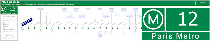
Paris Metro Line 12 map with stations, connections and points of interest
Although here you can see the maps for Metro Line 12, which travels between Mairie d'Aubervilliers and Mairie d'Issy with several Metro stations on route that have transport connections including the Porte de Versailles for how to to get to Parc des Expositions Paris Expo and Assemblee Nationale for getting to Les Invalides and other stops near tourist attractions.
Metro line 12 stops:
Mairie d'Aubervilliers (Plaine des Vertus), Aime Cesaire, Front Populaire, Porte de la Chapelle, Marx Dormoy, Marcadet - Poissonniers, Jules Joffrin, Lamark - Caulaincourt, Abessesses, Pigalle, Saint-Georges, Notre-Dame-de-Lorette, Trinite - d'Estienne d'Orves, Saint-Lazare, Madeleine, Concorde, Assemblee Nationale, Solferino, Rue du Bac, Sevres - Babylone, Rennes, Notre-Dame-des-Champs, Montparnasse - Bienvenue, Falguire, Pasteur, Volontaires, Vaugirard, Convention, Porte de Versailles, Corentin Celton, Mairie d'Issy.
Metro line 12 main transport connections:
Metro Lines 1, 2, 3, 4, 6, 8, 10, 13, 14. Train Lines: C, E, J, L, N, Funiculaire de Montmartre. Tram Lines: T2, T3a, T3b.
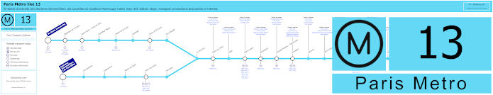
Paris Metro Line 13 map with stations, connections and points of interest
Whereas here you have the Line 13 Paris Metro map showing the route starting from either St-Denis Universite or Asnieres Gennevilliers - Les Courtilles, then linking up at La Fourche where it continues on to Chatillon Montrouge, which has several well known Metro stops such as Place de Clichy, Champs-Elysees - Clemenceau, Invalides and Montparnasse Bienvenue, which is how to get to Tour Montparnasse.
However, you will also see on the maps a Metro station called the Varenne stop, and it is here in the Metro line 13 station Varenne, you can discover two famous sculptures, which are the Thinker by Auguste Rodin located on the main platform and a statue of writer Honore de Balzac, and these are classed as the gateway to the Musee Rodin and Dante’s Gates of Hell where Divine Comedy joins the Human Comedy.
Metro line 13 stops:
St-Denis Universite, Basilique de St-Denis, Saint-Denis - Porte de Paris, Carrefour Pleyel, Mairie de St-Ouen, Garibaldi, Porte de St-Ouen, Guy Moquet, Asnieres - Gennevilliers Les Courtilles, Les Agnettes, Gabriel Peri, Mairie de Clichy, Porte de Clichy, Brochant, La Fourche, Place de Clichy, Liege, Saint-Lazare, Miromesnil, Champs-Elysees - Clemenceau, Invalides, Varenne, Saint-Francois-Xavier, Duroc, Montparnasse - Bienvenue, Gaite, Pernety, Plaisance, Porte de Vanves, Malakoff - Plateau de Vanves, Malakoff - Rue Etienne Dolet, Chatillon Montrouge.
Metro line 13 main transport connections:
Metro Lines: 1, 2, 3, 4, 6, 8, 9, 10, 12, 14. Train Lines: C, E, J, L, N. Tram Lines: T1, T3a, T3b, T5, T6, T8.
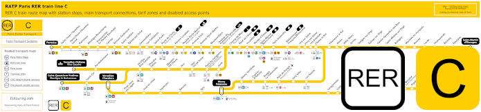
Yellow RER C train line map showing station stops, line branches, transport connections and zones
This train map shows the Paris RER C line which is colour coded yellow and covers train station stops like Champ de Mars - Tour Eiffel, Invalides for Les Invalides and Bibliotheque Francois Mitterrand. Then this RER line travels further out on different branches within the Paris region to tariff zone 5 and key places like Massy Palaiseau, St-Quentin en Yvelines, Versailles Chateau Rive Gauche for how to get to Chateau de Versailles, etc.
Paris RER C train line stops:
Pontoise*, St-Ouen l'Aumone, St-Ouen l'Aumone - Liesse, Pierrelaye, Montigny Beauchamp, Francoville - Le Plessis-Bouchard, Cernay, Ermont Eaubonne, St-Gratien, Epinay-sur-Seine, Gennevilliers, Les Gresillons, St-Ouen, Porte de Clichy, Pereire Levallois, Neuilly - Porte Maillot (Palais des Congres), Avenue Foch, Avenue Henri Martin, Boulainvilliers, Avenue du Pdt Kennedy (Maison de Radio France), Champ de Mars (Tour Eiffel), Pont d'Iena, Invalides, Musee d'Orsay, St-Michel (Notre Dame), Paris Gare d'Austerlitz, Bibliotheque Francois Mitterrand, Ivry-sur-Seine, Vitry-sur-Seine, Les Ardoines, Choisy le Roi, Villeneuve le Roi, Ablon, Athis Mons, Juvisy, Savigny-sur-Orge, Epinay-sur-Orge, Ste-Genevieve des Bois, St-Michel-sur Orge, Bretigny, Marolles en Hurepoix, Bouray, Lardy, Chamarande, Etrechy, Etampes, St-Martin d'Etampes*, Versailles Chateau Rive Gauche*, Porchefontaine, Viroflay Rive Gauche, Chaville - Velizy, Meudon - Val Fleury, Issy, Issy - Val de Seine, Pont du Garigliano (Hopital Europeen Georges Pompidou), Javel, St-Quentin en Yvelines*, St-Cyr, Versailles Chantiers**, Petit Jouy les Loges, Jouy en Josas, Vauboyen, Bievres, Igny, Massy Palaiseau**, Massy Verrieres, Chemin d'Antony, Rungis La Fraternelle, Pont de Rungis (Aeroport d'Orly), Orly Ville, Les Saules, Longjumeau, Chilly Mazarin, Gravigny Balizy, Petit Vaux, La Norville (St-Germain les Arpajon), Arpajon, Egly, Breuillet (Bruyeres le Chatel), St-Cheron, Sermaise, Dourdan, Dourdan la Foret*.
* Terminus Points. ** RER C Transfer Points.
Paris RER C train line main transport connections:
Metro Lines: 1, 2, 3, 4, 5, 6, 8, 9, 10, 12, 13, 14. Train Lines: B, D, H, J, N, U, TGV, TER. Tram Lines: T1, T2, T3a, T3b, T6, T7, T8, T9, T11, T13. Bus Lines: 183, 393, PC (98), TVM (14).
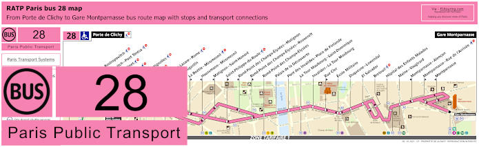
RATP Paris bus 28 map with stops, connections and street plan
Here you can see the maps and timetables for the Paris bus route RATP line 28 that travels between Porte de Clichy to Gare Saint-Lazare train station and on to Gare Montparnasse, and as you can see from the street plan, there are 2 bus stops shown for the Invalides transport hub called the Pont des Invalides - Place de Finlande and La Tour-Maubourg - Saint-Dominique, but on either side of the Boulevard de la Tour-Maubourg depending upon your direction of travel.
Paris bus line 28 stops:
Porte de Clichy, Berthier - Rostropovitch, Rostropovitch - Pont Teresa, Pont Cardinet, Legendre, Rome - Batignolles, Europe, Gare Saint-Lazare, Saint-Augustin, La Boetie - Miromesnil, Haussmann - Miromesnil, Matignon - Saint-Honore, Saint-Philippe-du-Roule, Rond-Point des Champs-Elysees - Matignon, Rond-Point des Champs-Elysees - Roosevelt, Rond-Point des Champs-Elysees, Palais de la Decouverte, Pont des Invalides - Place de Finlande, La Tour Maubourg - Saint-Dominique, Invalides - La Tour Maubourg, Rue Cler, Ecole Militaire, Duquesne-Lowendal, El Salvador, Breteuil, Hopital des Enfants Malades, Maine - Vaugirard, Montparnasse - Alencon, Montparnasse - Rue de l’Arrivee, Montparnasse, Gare Montparnasse.
Paris bus line 28 main transport connections:
Metro Lines: 1, 2, 3, 4, 6, 8, 9, 10, 12, 13, 14. Train Lines: C, E, J, L, N. Tram Line: T3b.
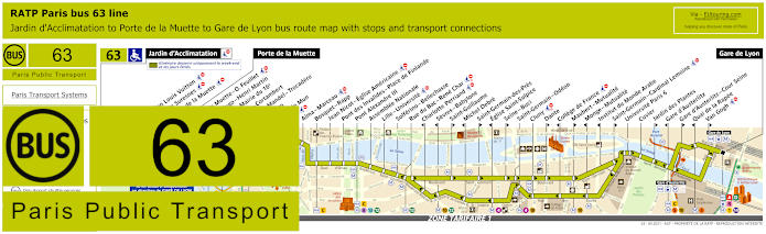
RATP Paris bus 63 map with stops, connections and street plan
With the same scenario as above, the RATP bus line 63 has different bus stops around Les Invalides depending upon your direction of travel, such as the Pont Alexandre III bus stop that will take you past numerous stops with attractions to either the Porte de la Muette terminus or the Gare de Lyon train station, although as you can see from the maps with their timetables, please bear in mind that some stops like Eglise Saint-Sulpice are only served in a particular direction.
Paris bus line 63 stops:
Jardin d'Acclimatation*, Fondation Louis Vuitton*, Route de Suresnes*, Pelouse de la Muette*, Porte de la Muette, Pte de la Muette - Octave Feuillet, Victor Hugo - Henri Martin, Pompe - Mairie du 16e, Sablons - Cortambert, Georges Mandel - Trocadero, Trocadero, Albert de Mun, Iena, Alma - Marceau, Bosquet - Rapp, Jean Nicot - Eglise Americaine, Pont des Invalides - Place de Finlande, Pont Alexandre III, Assemblee Nationale, Lille - Universite, Solferino - Bellechasse, Rue du Bac - Rene Char, Charlotte Perriand***, Sevres - Babylone***, Saint-Guillaume**, Michel Debre***, Saint-Germain-des-Pres**, Eglise Saint-Sulpice***, Seine - Buci**, Saint-Germain - Odeon, Cluny, Dante**, College de France***, Maubert - Mutualite**, Monge - Mutualite***, Institut du Monde Arabe***, Saint-Germain - Cardinal Lemoine**, Universite Paris 6, Cuvier, Jardin des Plantes**, Gare d'Austerlitz***, Gare d'Austerlitz - Cour Seine**, Quai de la Rapee***, Van Gogh**, Gare de Lyon.
* Only served on weekends, French public holidays and during school holidays. ** Stop served in direction of Paris Gare de Lyon. *** Stop served in direction of Jardin d'Acclimatation and Porte de la Muette.
Paris bus line 63 main transport connections:
Metro lines: 1, 4, 5, 6, 8, 9, 10, 12, 13, 14. Train lines: A, C, D, R.
RATP Paris bus line 69 with stops, connections and street plan
Yet this map and its timetables show the Paris Bus route for the RATP line 69, which travels between the Champ de Mars and Gambetta - Japon with well over 40 bus stops to tourist attractions like Esplanade des Invalides by the historical monument of Les Invalides where there is a bus stop on the Rue Saint-Dominique and another on Place des Invalides, although this bus route can change when the Paris E-Prix motor race is being held in the city.
Paris bus line 69 stops:
Champ de Mars, Rapp - La Bourdonnais, Champ de Mars - La Bourdonnais*, Bosquet - Grenelle*, Bosquet - Saint-Dominique**, Saint-Pierre du Gros Caillou, Invalides - La Tour-Maubourg*, La Tour-Maubourg - Saint-Dominique**, Esplanade des Invalides, Bourgogne, Grenelle - Bellechasse*, Solferino - Bellechasse, Musee d’Orsay*, Rue du Bac - Rene Char, Pont Royal - Quai Voltaire**, Henry de Montherlant*, Pont du Carrousel - Quai Voltaire*, Pont Royal**, Quai Francois Mitterrand**, Musee du Louvre*, Palais Royal - Musee du Louvre*, Pont des Arts**, Louvre - Rivoli* ***, Pont Neuf - Quai du Louvre**, Rivoli - Pont Neuf*, Chatelet*, Chatelet - Quai de Gesvres**, Hotel de Ville, Eglise Saint-Gervais**, Rue Vieille du Temple - Mairie du 4e*, Rue de Jouy** ***, Saint-Paul, Birague, Bastille - Rue Saint-Antoine, Bastille - Roquette**, Beaumarchais*, Breguet - Sabin**, Richard Lenoir*, Commandant Lamy**, Popincourt, Chemin Vert - Parmentier*, Voltaire - Leon Blum, Saint-Maur - Servan***, Roquette - Pere Lachaise, Folie-Regnault - Chemin Vert* ***, Pere Lachaise**, Auguste Metivier*, Muriers, Martin Nadaud***, Gambetta, Gambetta - Japon.
* Stop served in direction of Champ de Mars. ** Stop served in direction of Gambetta - Japon. *** Not accessible to those with reduced mobility.
Paris bus line 69 main transport connections:
Metro Lines: 1, 2, 3, 3bis, 4, 5, 7, 8, 9, 11, 12, 13, 14. Train Lines: A, B, C, D.
RATP Paris bus line 73 with stops, connections and street plan
Here you can see the Paris bus route 73 that travels from Musee d'Orsay and is one of the options for how to get to the Grande Arche La Defense, as this is the terminus point on a Monday to Saturday except for French National holidays, yet at all other times, this bus line goes through to La Garenne-Colombes - Charlebourg and as you can see from the street maps and timetables, the bus stop you would need for getting to Les Invalides is the Assemblee Nationale stop.
Paris bus line 73 stops:
La Garenne-Colombes - Charlebourg***, Nordmann***, Les Fauvelles***, Puvis de Chavannes***, Rue des Etudiants***, Leonardo de Vinci***, Faubourg de l’Arche** ***, Caron***, La Defense, Gambetta*, Boieldieu**, Alsace*, Gallieni**, Bellini**, Pont de Neuilly - Rive Gauche, Pont de Neuilly, Les Graviers, Rue de l’Hotel de Ville, Les Sablons, Marche, Montrosier*, Andre Maurois**, Palais des Congres**, Porte Maillot**, Porte Maillot - Palais des Congres*, Argentine, Charles de Gaulle - Etoile - Gde Armee, Charles de Gaulle - Etoile - Champs-Elysees, George V, La Boetie - Champs-Elysees, Rond-Point des Champs-Elysees, Champs-Elysees - Clemenceau, Concorde - Cours la Reine, Concorde*, Assemblee Nationale, Lille - Universite**, Musee d'Orsay.
* Stop served in direction of La Garenne-Colombes - Charlebourg or La Defense. ** Stop served in direction of Musee d'Orsay. *** Not served on a Sunday or French holidays.
Paris bus line 73 main transport connections:
Metro Lines: 1, 2, 6, 8, 9, 12, 13. Train Lines: A, C, L, U. Tram Line: T2.
RATP Paris bus line 80 with stops, connections and street plan
This shows the timetables and maps for Paris bus line 80 that travels between Porte de Versailles and Mairie du 18e - Jules Joffrin with stops on route for getting to the Theatre Marigny and the Champs Elysees Gardens, the Musee Quai Branly plus many others including the Eiffel Tower and Les Invalides by utilising the Ecole Militaire bus stop.
Paris bus line 80 stops:
Porte de Versailles, Firmin Gillot**, Boulevard Victor*, Hameau*, Vaugirard - Croix Nivert**, Hopital de Vaugirard**, Duranton*, Convention - Lecourbe*, Convention - Vaugirard**, Abbe Groult, Vaugirard**, Mairie du 15e, Peclet**, Cambronne - Lecourbe*, Miollis*, Fondary**, Cambronne, La Motte-Picquet - Grenelle, General de Bollardiere, Ecole Militaire, Bosquet - Grenelle, Bosquet - Saint-Dominique, Bosquet - Rapp, Alma - Marceau, Montaigne - Francois 1er, Rond-Point des Champs-Elysees, Rd-Pt des Champs-Elysees - F. D. Roosevelt*, Rd-Pt des Champs-Elysees - Matignon**, Saint-Philippe du Roule*, Matignon - Saint-Honore**, Haussmann - Miromesnil**, La Boetie - Miromesnil*, Saint-Augustin, Pasquier - Anjou*, Gare Saint-Lazare - Rome, Europe, Bucarest, Place de Clichy, Place de Clichy - Caulaincourt*, Clichy - Caulaincourt**, Damremont - Caulaincourt, Square Caulaincourt, Lamarck - Caulaincourt, Custine - Mont-Cenis, Custine - Ramey*, Marcadet*, Mairie du 18e - Jules Joffrin.
* Stop served in direction of Porte de Versailles. ** Stop served in direction of Mairie du 18e - Jules Joffrin.
Paris bus line 80 main transport connections:
Metro Lines: 1, 2, 3, 6, 8, 9, 10, 12, 13, 14. Train Lines: C, E, J, L. Tram Lines: T2, T3a.
RATP Paris bus line 82 with stops, connections and street plan
Although here you can see the maps and timetables for the RATP bus line 82 with the bus stop for Les Invalides being located by the Eglise du Dome on the Avenue de Tourville at the Place Vauban, with one stop on either side of the road called Vauban - Hotel des Invalides, depending on whether you are travelling to Luxembourg or in the direction of Neuilly - Hopital Americain.
Paris bus line 82 stops:
Neuilly - Hopital Americain, Bineau - La Saussaye*, Bineau - Chateau**, Perronet, La Saussaye - D'Argenson*, Chateau, General Gouraud, Rue de l'Eglise**, Sainte-Foy, Eglise Saint-Pierre, Chartres, Montrosier - Parmentier, Andre Maurois**, Palais des Congres**, Porte Maillot - Pershing*, Porte Maillot, Alphand, Foch, Victor Hugo - Poincare, Lauriston*, Kleber - Boissiere, Lubeck, Iena, Varsovie, Tour Eiffel, Champ de Mars, Champ de Mars - Suffren, General Detrie, General de Bollardiere, Ecole Militaire, Vauban - Hotel des Invalides, Saint-Francois-Xabier, Oudinot, Duroc, Maine - Vaugirard, Montparnasse - Alencon, Montparnasse**, Montparnasse - Cinemas*, Notre-Dame des Champs**, Vavin, Brea - Notre-Dame des Champs*, Assas - Duguay-Trouin**, Guynemer - Vavin, Campagne - Port Royal, Observatoire - Port Royal, Val de Grace, Auguste Comte, Luxembourg.
* Stop served in direction of Neuilly - Hopital Americain. ** Stop served in direction of Luxembourg.
Paris bus line 82 main transport connections:
Metro Lines: 1, 2, 4, 6, 8, 9, 10, 12, 13. Train Lines: B, C, N.
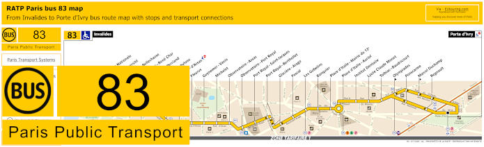
RATP Paris bus line 83 with stops, connections and street plan
But this map shows the Paris Bus route for the RATP line 83 that travels from the Rue Robert Esnault-Pelterie at Les Invalides called the Invalides stop going through to Porte d'Ivry, with numerous different bus stops in between including many that have transport connections like Observatoire - Port Royal, Les Gobelins, Place d'Italie - Auriol and Olympiades for example.
Paris bus line 83 stops:
Invalides, Assemblee Nationale, Lille - Universite, Solferino - Bellechasse, Rue du Bac - Rene Char, Charlotte Perriand, Sevres - Babylone, Rennes - d'Assas, Fleurus, Guynemer - Vavin, Michelet, Observatoire - Assas, Observatoire - Port Royal, Port Royal - Saint-Jacques, Port Royal - Berthollet, Glaciere - Arago, Pascal, Les Gobelins, Banquier, Place d’Italie - Mairie du 13e, Place d’Italie - Auriol, Institut Dentaire, Lycee Claude Monet, Tolbiac - Baudricourt, Olympiades, Ponscarme, Marcel Duchamp, Regnault, Porte d'Ivry.
Paris bus line 83 main transport connections:
Metro Lines: 5, 6, 7, 8, 10, 12, 13, 14. Train Lines: B, C. Tram Line: T3a.
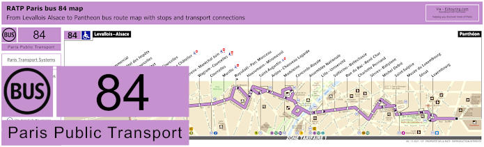
RATP Paris bus line 84 with stops, connections and street plan
Although, you will find that the Paris bus line 84 goes between Levallois - Alsace and the Pantheon with various bus stops on route close to tourist attractions including getting to Madeleine with its church and square and Les Invalides via the Assemblee Nationale stop, but please take note of the street maps and timetables as some stops only travel in a specific direction.
Paris bus line 84 stops:
Levallois - Alsace, Centre Commercial*, Reims - Hotel des Impots**, Wilson - Courcelles*, Reims - Pitet**, Porte de Courcelles, Pereire - Le Chatelier**, Pereire*, Pereire - Marechal Juin, Wagram - Courcelles, Courcelles, Murillo, Ruysdael - Parc Monceau**, Haussmann - Miromesnil, Saint-Augustin, Anjou - Chauveau Lagarde, Madeleine, Concorde - Royale, Assemblee Nationale, Lille -Universite, Solferino - Bellechasse, Rue du Bac - Rene Char, Charlotte Perriand, Sevres - Babylone, Michel Debre, Saint-Sulpice, Musee du Luxembourg, Senat, Luxembourg, Pantheon.
* Stop served in the direction of Levallois - Alsace. ** Stop served in the direction of Pantheon.
Paris bus line 84 main transport connections:
Metro Lines: 1, 2, 3, 4, 8, 9, 10, 12, 13, 14. Train Lines: B, C.
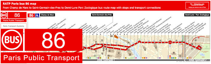
RATP Paris bus line 86 with stops, connections and street plan
The Paris bus line 86 is one of the ways for how to get to the Eiffel Tower via the Champ de Mars stop and terminus before travelling through to Demi-Lune - Parc Zoologique. Yet it also has a bus stop at Ecole Militaire which will get you to the famous landmark or in the opposite direction to the historical Les Invalides, plus there is also a bus stop called Duquesne - Lowendal on the Avenue Duquesne that will get you close to the Hotel des Invalides and the Tomb of Napoleon Bonaparte.
Paris bus line 86 stops:
Champ de Mars, Rapp - La Bourdonnais, Champ de Mars - La Bourdonnais, Ecole Militaire, Duquesne - Lowendal, Breteuil*, El Salvador**, Saint-Francois-Xavier, Oudinot**, Duroc**, Vaneau - Saint-Romain**, Vaneau - Babylone*, Bac - Saint-Placide**, Bac - Babylone*, Sevres - Babylone, Michel Debre, Eglise Saint-Sulpice*, Saint-Germain-des-Pres**, Seine - Buci**, Saint-Germain - Odeon, Cluny, Dante**, College de France*, Maubert - Mutualite**, Monge - Mutualite*, Saint-Germain - Cardinal Lemoine**, Institut du Monde Arabe*, Pont Sully - Quai de Bethune, Sully - Morland, Bastille - Henri IV, Bastille - Faubourg Saint-Antoine, La Boule Blanche, Ledru-Rollin - Faubourg Saint-Antoine, Crozatier, Hopital Saint-Antoine, Faidherbe - Chaligny, Claude Tillier, Chevreul, Nation - Saint-Antoine, Nation - Trone, Marsoulan, Pyrenees - Docteur Netter, Porte de Vincennes, Saint-Mande - Tourelle, Mairie de Saint-Mande, Eglise de Saint-Mande, Jean Mermoz, Demi-Lune - Parc Zoologique.
* Stop served in direction of Champ de Mars. ** Stop served in direction of Demi-Lune - Parc Zoologique.
Paris bus line 86 main transport connections:
Metro Lines: 1, 2, 4, 5, 6, 7, 8, 9, 10, 12, 13. Train Line: A. Tram Lines: T3a, T3b.
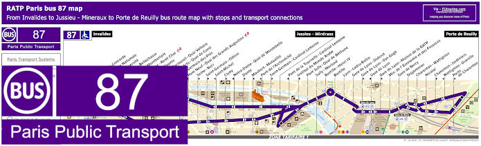
RATP Paris bus 87 map with stops, connections and street plan
Now this map and its timetables show the RATP Paris Bus route for line 87 that also starts from the Rue Robert Esnault-Pelterie at Invalides going through to Jussieu - Mineraux and further on to Porte de Reuilly terminus, which has over 35 bus stops including to Bastille and Gare de Lyon train station with its numerous transport connections for trains, Metro, buses, and night buses, although some bus stops are only served in a specific direction.
Paris bus line 87 stops:
Invalides, Pont de la Concorde*, Assemblee Nationale, Lille-Universite**, Solferino - Bellechasse**, Henry de Montherlant*, Rue du Bac - Rene Char**, Saint-Guillaume**, Pont du Carrousel - Quai Voltaire*, Pont des Arts - Quai de Conti*, Saint-Germain-des-Pres**, Pont Neuf - Quai des Grands Augustins*, Seine - Buci**, Saint-Germain - Odeon**, Saint-Michel*, Cluny**, Notre-Dame - Quai de Montebello*, Dante**, Maubert - Mutualite**, Pont de l'Archeveche*, Saint-Germain - Cardinal Lemoine**, Jussieu - Mineraux, Pont de la Tournelle - Cardinal Lemoine*, Institut du Monde Arabe**, Pont Sully - Quai de Bethune, Sully - Morland, Bastille - Henri IV, Bastille, Lyon - Ledru-Rollin, Gare de Lyon - Diderot, Gare de Lyon - Van Gogh**, Gare de Lyon*, Gare de Lyon - Maison de la RATP**, Min. de l'Economie et des Finances, Gare de Bercy, Dugommier, Charenton - Wattignies, Nicolai, Charenton - Jardiniers**, Wattignies - Gravelle*, Porte de Charenton**, Porte de Reuilly.
* Bus stop served in direction of Invalides. ** Bus stop served in direction of Porte de Reuilly.
Paris bus line 87 main transport connections:
Metro Lines: 1, 4, 5, 6, 7, 8, 10, 12, 13, 14. Train Lines: A, B, C, D, R. Tram Line: T3a.
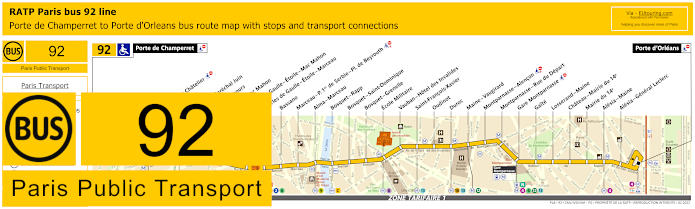
RATP Paris bus line 92 with stops, connections and street plan
Yet here we have the maps and timetables for the RATP Paris bus line 92 that goes from Porte de Champerret to Porte d'Orleans and for getting to Les Invalides you will see there is a bus stop called Vauban - Hotel des Invalides located at back of the impressive and historical complex on the Avenue de Tourville at the Place Vauban, which is where you can have fabulous views of the Eglise du dome we mentioned earlier.
Paris bus line 92 stops:
Porte de Champerret, Pereire - Le Chatelier*, Pereire*, Pereire - Marechal Juin, Pierre Demours, Ternes - Mac Mahon, Charles de Gaulle - Etoile - Mac Mahon, Charles de Gaulle - Etoile - Marceau, Bassano, Marceau - P. 1er de Serbie - Pl. de Beyrouth, Alma - Marceau, Bosquet - Rapp, Bosquet - Saint-Dominique, Bosquet - Grenelle, Ecole Militaire, Vauban - Hotel des Invalides, Saint-Francois-Xavier, Oudinot, Duroc, Maine - Vaugirard, Montparnasse - Alencon, Montparnasse - Rue du Depart, Gare Montparnasse, Gaite, Losserand - Maine, Chateau - Mairie du 14e, Mairie du 14e, Alesia - Maine, Alesia - General Leclerc, Porte d'Orleans.
* A direction dependant stop.
Paris bus line 92 main transport connections:
Metro Lines: 1, 2, 3, 4, 6, 8, 9, 10, 12, 13. Train Lines: A, C, N. Tram Line: T3a.
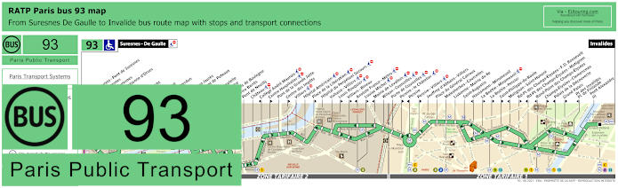
RATP Paris bus line 93 with stops, connections and street plan
However this map and its timetables shows the Paris bus route for the RATP bus line 93 that travels between Suresnes - De Gaulle in tariff zone 3 through to Invalides in central Paris where you will find bus stops located on the Quai d'Orsay for the Pont Alexandre III stop and again on the Rue Robert Esnault-Pelterie for the main Invalides bus stop, plus this route is one option for how to get to the Grand Palais and other famous attractions like the Champs Elysees.
Paris bus line 93 stops:
Suresnes - De Gaulle, Rue des Bourets - Pont de Suresnes, Pont de Suresnes, Mairie de Suresnes, Honore d'Estienne d'Orves, Henri IV, Jean Mace, Berty Albrecht, Pompidou, De Pressense, Residence Verdun, Bas Rogers, Wallace - Jean Jaures, Hopital - Pont de Puteaux, Bagatelle, Place de Bagatelle, Rue du Centre, Rue du Bois de Boulogne, Maurice Barres, Pont de Neuilly, Chateau, College Andre Maurois, Centre Hospitalier, Pont de la Grande Jatte, Centre des Impots, Villiers, Hopital Americain, Place de la Liberation, Hopital du Perpetuel Secours, Voltaire - Villiers, Louis Rouquier, Villiers - Bineau, Anatole France - Metro, Louise Michel, Mairie de Levallois, Wilson - Courcelles, Porte de Courcelles, Pereire - Le Chatelier, Pereire, Pereire - Villiers, Jouffroy d'Abbans - Villiers, Place du General Catroux, Malesherbes - Courcelles, Lisbonne - Mairie du 8e, Saint-Augustin, Haussmann - Miromesnil, La Boetie - Percier, La Boetie - Miromesnil, Saint-Philippe-du-Roule, Matignon - Saint-Honore, Rd-Pt des Champs-Elysees - F. D. Roosevelt, Rd-Pt des Champs-Elysees - Matignon, Rond-Point des Champs-Elysees, Champs-Elysees - Clemenceau, Palais de la Decouverte, Grand Palais, Pont des Invalides - Place de Finlande, Pont Alexandre III, Invalides.
Paris bus line 93 main transport connections:
Metro Lines: 1, 2, 3, 8, 9, 13. Train Line: C. Tram Line: T2.
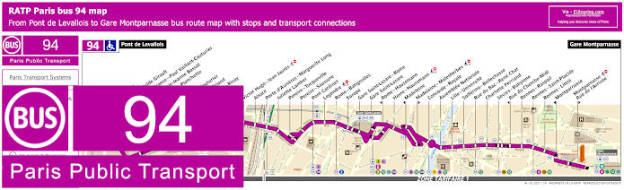
RATP Paris bus line 94 with stops, connections and street plan
Yet these maps and timetables show the Paris bus line 94 that travels between Pont de Levallois in ticket tariff zone 2 through to Gare Montparnasse in central Paris and for reaching Les Invalides the nearest bus stop in walking distance is the Assemblee Nationale stop, although some stops such as Concorde are only served in a specific direction.
Paris bus line 94 stops:
Pont de Levallois, Pompidou, Parc Mathilde Girault, Anatole France - Paul Vaillant Couturier, Place Marie-Jeanne Bassot, Parc de la Planchette, Baudin, Vaillant-Couturier, Aristide Briand, Rouquier - Rivay, Marjolin, Trezel, Victor Hugo - Jean Jaures, Alsace, Porte d'Asnieres - Marguerite Long, Juliette Lamber, Pereire - Tocqueville, Pereire - Saussure, Pont Cardinet, Legendre, Rome - Batignolles, Europe, Gare Saint-Lazare - Rome, Gare Saint-Lazare, Rome - Haussmann, Havre - Haussmann, Madeleine, Madeleine - Malesherbes, Concorde - Royale, Assemblee Nationale, Lille - Universite, Solferino - Bellechasse, Rue de Bac - Rene Char, Charlotte Perriand, Sevres - Babylone, Rue du Cherche-Midi, Rennes - Raspail, Rennes - Saint-Placide, Rennes - Littre, Montparnasse, Montparnasse - Rue de l'Arrivee, Gare Montparnasse.
Paris bus line 94 main transport connections:
Metro Lines: 1, 2, 3, 4, 6, 8, 9, 10, 12, 13, 14. Train Lines: E, J, L, N. Tram Lines: T3b.
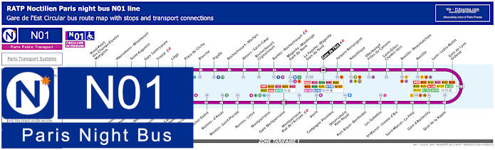
Paris Noctilien night bus N01 map with stops and transport connections
In addition, there are also the Noctilien buses, which are the Paris night buses that run when other transport has stopped for the evening, and here you can see the maps and timetables for Noctilien bus line N01, which is referred to as Circulaire Interieure and provides a night bus route in a complete circuit with stops at many different tourist attractions including Pont Alexandre III on the Quai d'Orsay for Les Invalides, plus other transport hubs like Gare de l'Est, Bastille and Gare d'Austerlitz train station, etc.
Paris night bus line N01 stops:
Gare de l'Est, Jacques Bonsergent, Republique, Oberkampf - Filles du Calvaire, Saint-Gilles - Chemin Vert, Bastille - Beaumarchais, Bastille, Lyon - Ledru-Rollin, Gare de Lyon - Diderot, Quai de la Rapee, Gare d'Austerlitz, Saint-Marcel - La Pitie, Saint-Marcel - Jeanne d'Arc, Les Gobelins, Port Royal - Berthollet, Observatoire - Port Royal, Campagne Premiere, Vavin, Montparnasse - Rue de l'Arrivee, Gare Montparnasse, Montparnasse, Rennes - Littre, Rennes - Saint-Placide, Rennes - d'Assas, Michel Debre, St-Germain-des-Pres, Pont du Carrousel - Quai Voltaire, Henry de Montherlant, Assemblee Nationale, Pont Alexandre III, Palais de la Decouverte, Rond-Point des Champs-Elysees - Matignon, Haussmann - Miromesnil, Saint-Augustin, Gare Saint-Lazare, Trinite, Liege, Place de Clichy, Blanche, Pigalle, Rochechouart - Martyrs, Anvers - Sacre-Coeur, Rochechouart - Clignancourt, Barbes - Rochechouart, Magenta - Mauberge - Gare du Nord, La Fayette - Magenta - Gare du Nord, Gare de l'Est.
Paris night bus line N01 main transport connections:
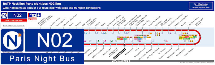
Paris Noctilien night bus N02 map with stops and transport connections
Whereas this shows the Noctilien N02 night bus line, known as the Circulaire Exterieure, which also provides a night bus service in a complete circuit, also with a stop for Les Invalides on Quai d'Orsay called Pont Alexandre III and additional night bus stops for transport connections to other night bus lines, trains and Metro including Gare Montparnasse, Gare de Saint-Lazare, Gare de Lyon and Gare du Nord train station where the Eurostar arrives.
Paris night bus line N02 stops:
Gare Montparnasse, Montparnasse, Vavin, Campagne Premiere, Observatoire - Port Royal, Port Royal - Berthollet, Les Gobelins, Saint-Marcel - Jeanne d'Arc, Saint-Marcel - La Pitie, Gare d'Austerlitz, Quai de la Rapee, Gare de Lyon - Diderot, Lyon - Ledru-Rollin, Bastille, Bastille - Beaumarchais, Saint-Gilles - Chemin Vert, Oberkampf - Filles du Calvaire, Republique, Jacques Bonsergent, Gare de l'Est, La Fayette - Magenta - Gare du Nord, Magenta - Maubeuge - Gare du Nord, Barbes - Rochechouart, Rochechouart - Clignancourt, Anvers - Sacre-Coeur, Rochechouart - Martyrs, Pigalle, Blanche, Place de Clichy - Caulaincourt, Place de Clichy, Bucarest, Europe, Gare Saint-Lazare - Rome, Saint-Augustin, La Boetie - Percier, Rond-Point des Champs-Elysees - Franklin D. Roosevelt, Palais de la Decouverte, Pont Alexandre III, Assemblee Nationale, Solferino - Bellechasse, Saint-Guillaume, Saint-Germain-des-Pres, Michel Debre, Rennes - d'Assas, Rennes - Saint-Placide, Rennes - Little, Montparnasse - Rue de l'Arrivee, Gare Montparnasse.
Paris night bus line N02 main transport connections:
Paris Open Tour bus sightseeing tour map for Blue, Red and Green bus lines with stops and timetables
Alternatively, if you like the idea of utilising a sightseeing tour bus, then you will find that the company Open Tour offer a hop on and hop off service with numerous stops located at strategic tourist attractions on three different routes that you can switch between.
So when it comes to getting to Les Invalides, you will find that the Blue line bus tour has Stop 16 called Pont Alexandre III - Invalides, which is located at 41 Quai d'Orsay, 75007 right by the River Seine, so you would walk up to the famous monument, but going in a southerly direction.
1: Haussman - Opera - Visitor centre - 13 Rue Auber, 75009 2: Opera - 4 Septembre - 49 Avenue de l'Opera, 75002 3: Palais-Royal - Comedie Francaise - 3 Avenue de l'Opera, 75002 4: Musee du Louvre - Place du Carrousel, 75001 5: Pont Neuf - Quai des Orfevres - Face au 64 Quai des Orfevres, 75001 6: Notre-Dame - Visitor Centre - 4 Rue du Petit Pont, 75005 7: Musee d'Orsay - 8 Quai Anatole France, 75007 8: Concorde - 12 Place de la Concorde, 75008 9: Champs-Elysees - Grand Palais - 14 Avenue des Champs-Elysees, 75008 10: Champs-Elysees - Disney Store - 60 Avenue des Champs-Elysees, 75008 11: Champs-Elysees - George V - 116 Avenue des Champs-Elysees, 75008 12: Champs-Elysees - Open Tour Kiosque - 125 Avenue des Champs-Elysees, 75008 13: Trocadero - Avenue du President Wilson, 75016 14: Tour Eiffel - 69 Quai Branly, 75007 15: Pont de l'Alma - 87 Quai Branly, 75007 16: Pont Alexandre III - Invalides - 41 Quai d'Orsay, 75007 17: Concorde-Royale - 4 Rue Royale, 75008 18: Madeleine - 18 Place de la Madeleine, 75008
Paris Open Tour bus sightseeing tour maps with stops and timetables:
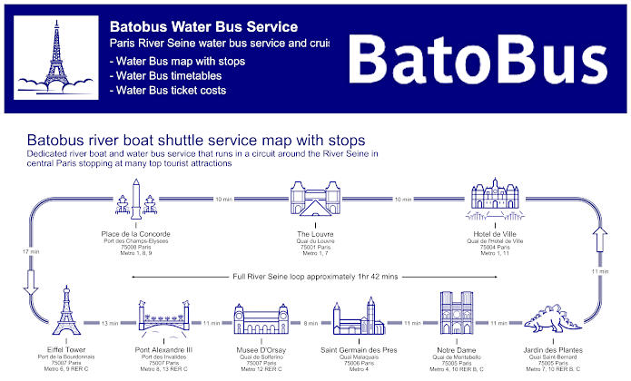
Paris Batobus map with river stops, timetables and ticket prices
Additionally, you have the Batobus, which is a water bus that operates along the River Seine, and again being a hop on and hop off sightseeing water bus service, this stops at key locations close to many tourist attractions including Les Invalides, with the stop being called the Pont Alexandre III, and the docking station is Port des Invalides.
Yet we would like to point out that being the quays where the Batobus docks are on the banks of the River Seine, these are not accessible to those with reduced mobility and wheelchair users to do steps having to be negotiated, that is except for the Eiffel Tower water bus stop.
Batobus River Seine stops with attractions:
Eiffel Tower - Port de la Bourdonnais, Pont Alexandre III - Port des Invalides, Musee D'Orsay - Quai de Solferino, Saint Germain des Pres - Quai Malaquais, Notre Dame - Quai de Montebello, Jardin des Plantes - Quai Saint-Bernard, Hotel de Ville - Quai de l'Hotel de Ville, The Louvre - Quai du Louvre, Place de la Concorde - Port des Champs-Elysees.
Batobus main transport connections:
Metro lines 1, 4, 6, 7, 8, 9, 10, 11, 12 and 13 RER B and C
Batobus ticket prices:
Adult One Day Pass €17.00 Adult Two Day Pass €19.00 Child One Day Pass (aged 3-15 years) €8.00 Child Two Day Pass (aged 3-15 years) €10.00 Child (aged -3 years) FREE
Batobus water bus maps, timetables and ticket prices available:
Construction, general information, plans and history of Hotel des Invalides
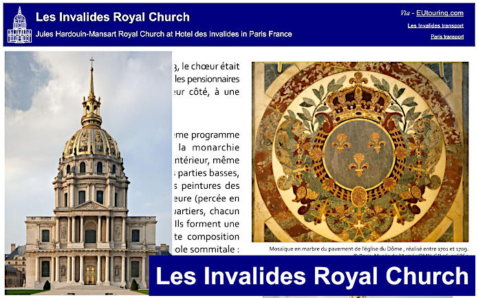
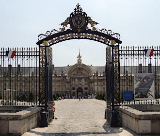
Even though in French, this first guide is a general presentation of Les Invalides from the start of construction through to the inauguration of the Eglise du Dome and further on to the Tomb of Napoloeon and the other tombs, statues, historical plans and details of features that you can discover within the historical complex also referred to as the Hotel des Invalides where you can discover various museums.
Again in French, here you can discover information about the royal church of Les Invalides called the Eglise du Dome designed by Jules Hardouin-Mansart, which has the beautiful golden dome and an ornate cupola inside that you can enjoy on your visit, which is now home to the Tomb of Napoleon Bonaparte.
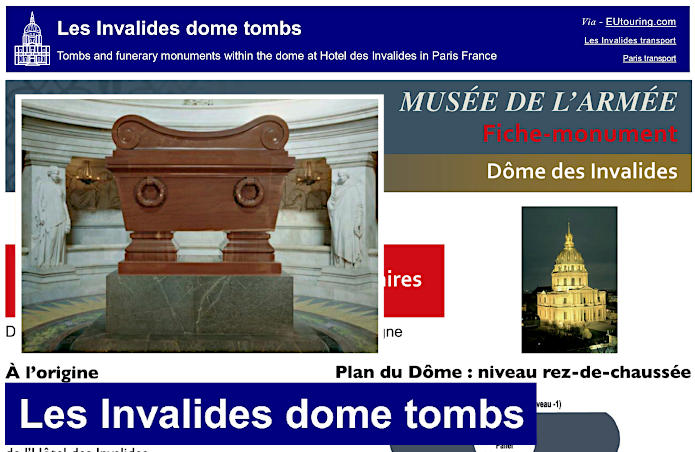
Whereas here you can see the plans of Les Invalides Dome with the tombs and funerary monuments, and the first plan shows the ground floor level with various tombs including Jerome and Joseph who were brothers of Napoleon Bonaparte, plus generals such as Ferdinand Foch. There is also a plan for level -1, although you will see that the parts highlighted in yellow are not accessible to the public. But further through, even though in French you can discover information about each individual tomb, funerary monument and who the people were, etc.
Paris Les Invalides Dome tombs and monuments plans available:
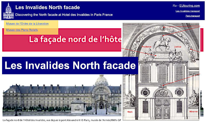
Although here you can see the information on the North facade of Les Invalides providing the details of the decoration and statues on the main pavilion, its construction, details of the fire pots and armour style skylights on the roof and much more dating from the reign of King Louis XIV.
Paris Les Invalides North facade guides available:
Les Invalides statue of Napoleon I by Pierre-Charles Simart
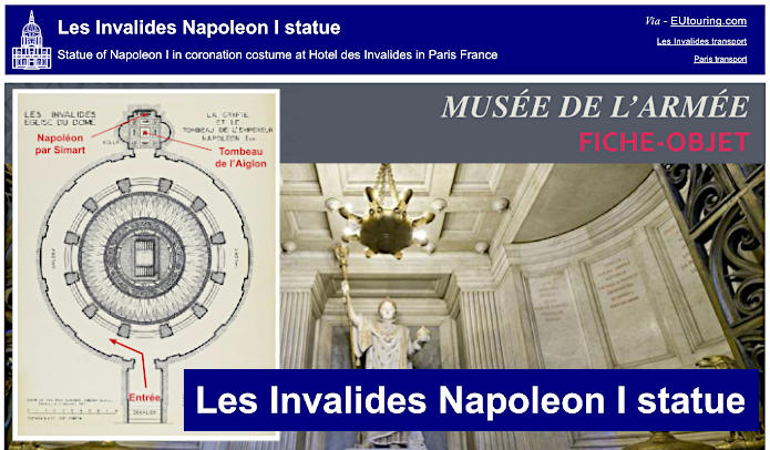
Here you can see in-depth details of the Napoleon I statue by Pierre-Charles Simart which can be found in the Eglise du Dome of Les Invalides that was designed to portray him in a sacred costume, and constructed in marble, it is located in the ambulatory in the axis of the staircase and sarcophagus of Napoleon Bonaparte.
Paris Les Invalides statue of Napoleon I guides available:
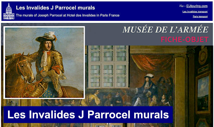
Decorating the ancient refectory of the north west part of Les Invalides, or Hotel des Invalides, many murals and paintings were rediscovered during restoration works that were undertaken for the Musee de l'Armee, and dating from the 17th century by Joseph Parrocel, here you can discover more about the artist and these impressive paintings.
Paris Les Invalides Joseph Parrocel murals guides available:
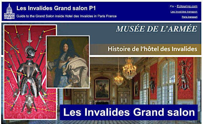
Although the Grand Salon is not normally open to the public except for when events such as concerts and receptions have been organised, here you can see the many details including the framed outfits with armour and armaments like swords in frames including details of their origins and dates. Not forgetting there is also the gallery of portraits with detailed information on these, but the one depicting Louis XIV proudly positioned above the historical fireplace in the Grand Salon of Les Invalides, is actually a copy produced in the 1800s, as the original is held within the Musee du Louvre.
Les Invalides Plans-Reliefs museum guide and access plan
Here we have the information and an access plan for Musee des Plans-Reliefs including opening times, which is one of the museums located within Les Invalides that has historical very detailed three dimensional map plans of various areas in France, with a tour awaiting you, as though you are travelling in the footsteps of works by Alexandre Dumas, The Three Musketeers, The Count of Monte-Cristo, etc.
Paris Les Invalides Plans-Reliefs museum guides available:
You will be able to discover another museum located within Les Invalides called the Musee de l'Ordre de la Liberation, which is all to do with World War II including the deportation, General Charles de Gaulle, the French Resistance, etc and although in French, here you can see a plan of the museum with its different section along with 12 key exhibits highlighted within the permanent collection.
Paris Les Invalides liberation museum guides available:
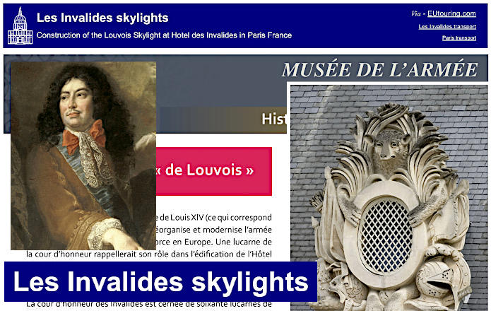
There are actually 60 skylight style dormers that surround the Courtyard of Honour, or Cour d'Honneur in French, which are all designed to be decorated with trophies of weapons and military or heraldic attributes, and yet, there is one that completely differs. So here, even though again in French, you can see the details of this particular skylight of Louvois that was put in place depicting a wolf, as a discreet reminder that the Secretary of State, Marquis de Louvois played a key role in the construction of Les Invalides as the King would not have allowed his coat of arms on the Hotel des Invalides.
Hotel National des Invalides, Esplanade des Invalides, 129 Rue de Grenelle, 75007, Paris, Ile de France, France GPS: 48.8540, 2.3124 Tel: 0033 8 10 11 33 99 (local rate call from France, although from other countries or mobile charges may vary) Fax: 0033 1 44 42 37 64 Bookings and private receptions Tel: 0033 1 44 42 33 75