How to get to Parc des Princes football stadium in Paris using public transport
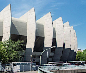
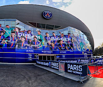
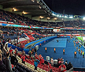
The Parc des Princes is a football stadium in Paris, home to the Paris Saint-Germain team, which can cater for over 47,000 fans for a football match within its four covered all-seater stands. Although the Stade de France has taken over many international games, the Parc des Princes still plays host to international matches and other sporting events including Rugby matches. So below you can discover how to get to the Parc des Princes via public transport, with maps, timetables and plans that can all be downloaded via PDF or image format to your PC or mobile device.
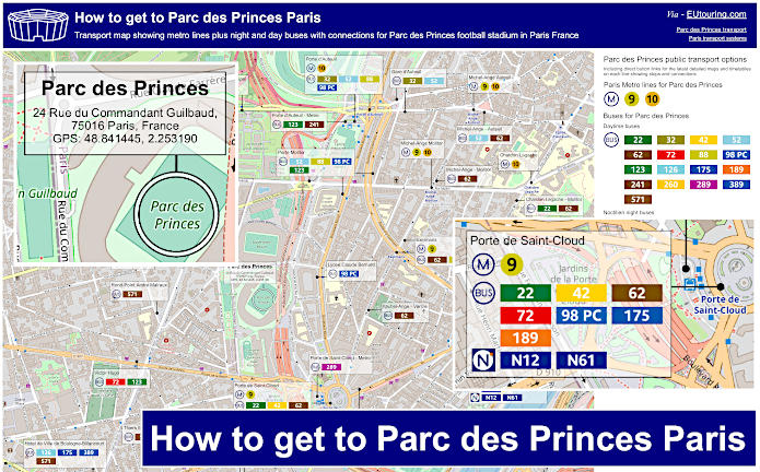
Parc des Princes transport map of Metro lines and bus lines with stops, connections and street plan
Here you can see a street map showing the location of the Parc des Princes football stadium and where the various options of Paris public transport are located, which includes Metro lines, day buses and the Noctilien night buses that will all get you within around 200 to 1500 metres, or about a mile from the sports venue at the furthest stops pin-pointed.
How to get to Parc des Princes public transport maps available:
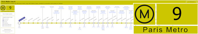
Paris Metro Line 9 stations, connections and points of interest
This shows the maps for Paris Metro line 9 that travels between Pont de Sevres and Mairie de Montreuil with numerous transport connections on route, and the closest Metro station to Parc des Princes is called the Porte de Saint-Cloud stop, which is approximately 350 metres walk from the football stadium.
Metro line 9 stops:
Pont de Sevres, Billancourt, Marcel Sembat, Porte de Saint-Cloud, Exelmans, Michel-Ange - Molitor, Jasmin, Ranelagh, La Muette, Rue de la Pompe, Trocadero, Iena, Alma - Marceau, Franklin D Roosevelt, Saint-Philippe-du-Roule, Miromesnil, Saint-Augustin, Havre - Caumartin, Chaussee d'Antin - La Fayette, Richelieu - Drouot, Grands Boulevards, Bonne Nouvelle, Strasbourg - Saint-Denis, Republique, Oberkampf, Saint-Ambrose, Voltaire, Charonne, Rue des Boulets, Nation, Buzenval, Maraichers, Porte de Montreuil, Robespierre, Croix de Chavaux, Mairie de Montreuil.
Metro line 9 main transport connections:
Metro Lines: 1, 2, 3, 4, 5, 6, 7, 8, 10, 11, 13, 14. Train Lines: A, C, E. Tram Lines: T2, T3b. Bus Line: RoissyBus.
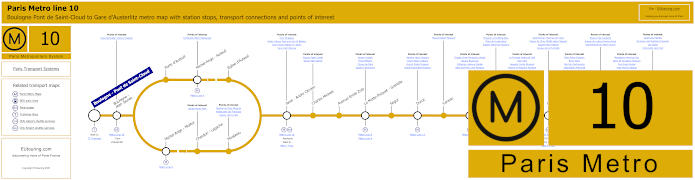
Paris Metro Line 10 stations, connections and points of interest
Whereas this shows the Paris Metro line 10, which is quite a bit further walk from Parc des Princes, and travelling from Gare d'Austerlitz train station, as you can see from these Metro maps, the line splits after the Javel - Andre Citreon stop, so if you are going to the stadium heading towards the terminus of Boulogne - Pont de Saint-Cloud, you would need the Porte d'Auteuil stop, or if heading back towards central Paris, then you would need the Michel-Ange Molitor metro station.
Metro line 10 stops:
Boulogne - Pont de Saint-Cloud, Boulogne - Jean Jaures, Porte d'Auteuil, Michel-Ange - Auteuil, Eglise d'Auteuil, Michel-Ange - Molitor, Chardon - Lagache, Mirabeau, Javel - Andre Citroen, Charles Michels, Avenue Emile Zola, La Motte-Picquet - Grenelle, Segur, Duroc, Vaneau, Sevres - Babylone, Mabillon, Odeon, Cluny - La Sorbonne, Maubert - Mutualite, Cardinal Lemoine, Jussieu, Gare d'Austerlitz.
Metro line 10 main transport connections:
Metro Lines: 4, 5, 6, 7, 8, 9, 10, 12, 13. Train Lines: B, C. Tram Line: T2.
RATP Paris bus line 22 with stops, connections and street plan
The Paris bus line 22 run by the transport company RATP travels from Porte de Saint-Cloud, which is the stop and terminus you would need for Parc des Princes, going through to Gare Saint-Lazare train station with an additional major stop on route of Charles de Gaulle - Etoile by the Arc de Triomphe historical monument in Paris, but as you can see from the bus maps and timetables, there are numerous bus stops that are direction dependant, such as Chardon-Lagache - Molitor and Assomption - Radio France.
Paris bus line 22 stops:
Porte de Saint-Cloud, Porte de Saint-Cloud - Murat, Versailles - Chardon-Lagache, Versailles - Exelmans**, Jouvenet*, Victorien Sardou**, Chardon-Lagache - Molitor*, Wilhem**, Pont Mirabeau**, Eglise d’Auteuil, George Sand - La Fontaine**, Perrichont*, Jasmin**, Theophile Gautier - Rue Gros*, Place du Docteur Hayem - Radio France*, Assomption - Radio France*, Ranelagh**, Les Vignes - Boulainvilliers RER*, La Muette - Boulainvilliers, Place Possoz, La Tour, Scheffer, Trocadero, Kleber - Boissiere, Kleber - Paul Valery, Charles de Gaulle - Etoile - Kleber, Charles de Gaulle - Etoile, Hoche - Saint-Honore, Friedland - Haussmann, Haussmann - Courcelles, Haussmann - Miromesnil, Saint-Augustin - La Boetie*, Saint-Augustin, Pasquier - Anjou*, Gare Saint-Lazare.
* Stop served in direction of Porte de Saint-Cloud. ** Stop served in direction of Gare Saint-Lazare.
Paris bus line 22 main transport connections:
Metro Lines: 1, 2, 3, 6, 9, 10, 12, 13, 14. Train Lines: A, C, E, J, L.
RATP Paris bus line 32 with stops, connections and street plan
The Porte d'Auteuil bus station is the terminus for the Paris bus line 32, which means a walk of around 700 metres to get to the Parc des Princes football stadium, and as you can see from these bus maps and timetables, it travels from here through to Gare de l'Est train station in Paris, with numerous bus stops on route including Iena for how to get to the Eiffel Tower.
Paris bus line 32 stops:
Porte d'Auteuil, Gare d’Auteuil**, Alfred Capus, Raffet, Porte de Passy, Louis Boilly**, Avenue Ingres*, La Muette - Boulainvilliers, Passy - Boulainvilliers**, Place de Passy**, Place Possoz*, Jean Bologne**, La Tour*, Passy - La Tour**, Scheffer, Trocadero, Albert de Mun, Iena, Marceau - P. 1er de Serbie - Pl. de Beyrouth, Pierre Charron - Francois 1er, La Boetie - Champs-Elysees, Rd-Pt des Champs-Elysees - Matignon**, Saint-Philippe du Roule*, Matignon - Saint-Honore**, Haussmann - Miromesnil**, La Boetie - Miromesnil*, Saint-Augustin, Pasquier - Anjou*, Gare Saint-Lazare**, Rome - Haussmann*, Havre - Haussmann**, Havre - Caumartin*, Auber, Opera**, Chaussee d'Antin*, Choiseul**, Le Peletier - Haussmann*, Richelieu - Drouot**, Carrefour Chateaudun*, Cadet*, Square Montholon*, Grands Boulevards**, Poissonniere - Bonne Nouvelle**, Hauteville*, Porte Saint-Denis**, Chateau d’Eau**, Faubourg - Saint-Denis*, Gare de l'Est.
* Stop served in direction of Porte d'Auteuil. ** Stop served in direction of Gare de l'Est.
Paris bus line 32 main transport connections:
Metro Lines: 1, 3, 4, 5, 6, 7, 8, 9, 10, 12, 13, 14. Train Lines: C, E, J, L, P.
RATP Paris bus line 42 with stops, connections and street plan
Whereas these maps and timetables show the Paris bus line 42 that travels from Cours de l'Ile Seguin, which is one option for how to get to La Seine Musicale, and the route travels through to Gare Saint-Lazare, and as you can see, this is also an option for getting to Madeleine along with many other Paris tourist attractions, not forgetting the Parc des Princes football stadium via the Porte de Saint-Cloud bus stop.
Paris bus line 42 stops:
Cours de l'Ile Seguin, Parch de Billancourt, Place Jules Guesde, Marche de Billancourt, Marcel Sembat - Metro, Rene Descartes, Henri Martin, Porte de Saint-Cloud, Porte de Saint-Cloud-Murat, Versailles - Chardon Lagache, Versailles Exelmans, Pont du Garigliano, Hopital Europeen - Georges Pompidou, Rue Leblanc (Entree Principale de l'Hop.), Leblanc - Delbarre**, Place Balard, Balard - Lecourbe*, Saint-Charles - Balard**, Lecourbe - Vasco de Gama*, Vasco de Gama - Lourmel*, Lourmel - Felix Faure*, Rond-Point Saint-Charles**, Convention - Saint-Charles**, Convention - Lourmel*, Charles Michels, Theatre, Rue Rouelle, Docteur Finlay**, Dupleix, Desaix, Champ de Mars - Suffren, Rapp - La Bourdonnais, Monttessuy, Tour Eiffel, Bosquet - Rapp, Alma - Marceau, Montaigne - Francois 1er, Rond-Point des Champs-Elysees, Champs-Elysees - Clemenceau, Concorde - Cours la Reine, Concorde*, Concorde - Royale**, Madeleine - Malesherbes*, Madeleine*, Havre - Haussmann, Gare Saint-Lazare - Havre*, Gare Saint-Lazare.
* Stop served in the direction of Cours de l'Ile Seguin. ** Stop served in the direction of Gare Saint-Lazare.
Paris bus line 42 main transport connections:
Metro Lines: 1, 3, 6, 8, 9, 10, 12, 13, 14. Train Lines: C, E, J, L. Tram Line: T3a.
RATP Paris bus line 52 with stops, connections and route plan
Travelling from Parc de Saint-Cloud through to Opera - Rue Halevy, as you can see from the Paris bus line 52 maps and timetables, there is only a partial service between Charles de Gaulle - Etoile and Porte d'Auteil at certain times, so for getting to Parc des Princes you would need the Porte d'Auteil in this instance, but if not, a closer walk to the football stadium would be by utilising the Porte Molitor bus stop.
Paris bus line 52 stops:
Parc de Saint-Cloud, La Colline**, Pont de Saint-Cloud - Rive Gauche**, Pont de Saint-Cloud - Albert Kahn, Rhin et Danube - Metro, Rue de Silly, Rue de Billancourt, Jean Jaures, Rue de l’Est, Denfert-Rochereau, La Tourelle, Porte Molitor, Porte d’Auteuil***, Gare d’Auteuil, Michel-Ange - Auteuil, Mozart - La Fontaine*, Eglise d’Auteuil**, George Sand - La Fontaine*, Perrichont**, Leopold II*, La Fontaine - Radio France**, Rodin**, Ranelagh**, Assomption - Radio France*, Les Vignes - Boulainvilliers*, La Muette - Boulainvilliers, Nicolo - Jean Richepin, Pompe - Mairie du 16e, Lycee Janson de Sailly, Place Jean Monnet, Bugeaud, Victor Hugo - Poincare, Victor Hugo - Paul Valery, Charles de Gaulle - Etoile - Victor Hugo, Charles de Gaulle - Etoile - Friedland***, Hoche - Saint-Honore, Friedland - Haussmann, Haussmann - Courcelles, Saint-Philippe du Roule, La Boetie - Percier*, Matignon - Saint-Honore**, Haussmann - Miromesnil**, Saint-Augustin - La Boetie*, Saint-Augustin**, Anjou - Chaveau Lagarde, Madeleine - Malesherbes*, Madeleine, Capucines - Caumartin, Opera - Rue de la Paix**, Opera - Rue Halevy.
* Stop served in direction of Parc de Saint-Cloud. ** Stop served in direction of Opera - Rue Halevy. *** Only a partial service operates in the evening between Porte d'Auteuil and Charles de Gaulle Etoile - Friedland.
Paris bus line 52 main transport connections:
Metro Lines: 1, 2, 3, 6, 7, 8, 9, 10, 12, 13, 14. Train Lines: A, C. Tram Line: T2.
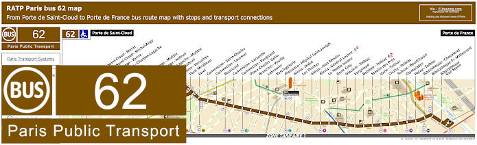
RATP Paris bus line 62 with stops, connections and street plan
Yet here you have the RATP bus line 62 that travels between Porte de Saint-Cloud and Porte de France, which is one option for getting to Tour Montparnasse or Bibliotheque Francois Mitterrand, as you can see from the street maps and their timetables, yet please take note that some stops are only served in a particular direction, but the nearest stop for Parc des Princes Paris stadium is the Porte de Saint-Cloud bus station terminus.
Paris bus line 62 stops:
Porte de Saint-Cloud, Porte de Saint-Cloud - Murat, Porte de Saint-Cloud - Michel-Ange, Michel Ange-Varize, Versailles - Chardon - Lagache, Exelmans, Jouvenet, Michel-Ange - Molitor, Michel-Ange-Auteuil, Chardon - Lagache - Molitor, Eglise d’Auteuil, Wilhem - Versailles, Pont Mirabeau, Javel, Convention - Saint-Charles, Convention - Lourmel, Boucicaut, Convention - Lecourbe, Convention - Vaugirard, Place Charles Vallin, Brancion - Vouille, Labrouste, Vercingetorix, Plaisance - Hopital Saint-Joseph, Alesia - Didot, Les Plantes, Alesia - Jean Moulin, Alesia - General Leclerc, La Tombe Issoire, Rene Coty, Glaciere - Tolbiac, Vergniaud, Bobillot - Tolbiac, Moulin des Pres, Italie - Tolbiac, Choisy - Tolbiac, Tolbiac - Baudricourt, Olympiades, Patay - Tolbiac, Bibliotheque - Chevaleret, Bibliotheque Fr. Mitterrand, Bibliotheque - Rue Mann, Porte de France.
Paris bus line 62 main transport connections:
Metro Lines: 4, 7, 8, 9, 10, 12, 13, 14. Train Line: C. Tram Line: T3a.
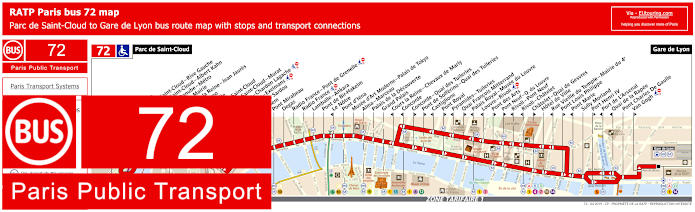
RATP Paris bus 72 map with stops, connections and street plan
You will find that the RATP bus line 72 travels between Parc de Saint-Cloud and Gare de Lyon train station and is a popular Paris bus route that will get you to numerous different tourist attractions and event venues including getting to the Grand Palais, and just like the above bus line, the nearest bus stop to Parc des Princes football stadium is the Porte de Saint-Cloud stop, yet please take note of the maps and timetables carefully as may stops are only served in a particular direction.
Paris bus line 72 stops:
Parc de Saint-Cloud, La Colline, Pont de Saint-Cloud - Rive Gauche, Pont de Saint-Cloud - Albert Kahn, Rhin et Danube - Metro, Ancienne Mairie, Route de la Reine - Jean Jaures, Victor Hugo, La Tourelle, Porte de Saint-Cloud, Porte de Saint-Cloud - Murat, Versailles - Chardon Lagache, Versailles - Exelmans, Victorien Sardou, Wilhem, Pont Mirabeau, Degas, Radio France - Pont de Grenelle, Radio France, Lamballe - Ankara, Pont de Bir-Hakeim, Le Notre*, Pont d’Iena, Musee d’Art Moderne - Palais de Tokyo, Alma - Marceau, Palais de la Decouverte, Grand Palais, Cours la Reine - Chevaux de Marly*, Concorde*, Concorde - Quai des Tuileries**, Pont de Solferino - Quai des Tuileries**, Castiglione*, Pont Royal**, Pyramides - Tuileries*, Quai Francois Mitterrand**, Palais Royal - Musee du Louvre*, Louvre - Rivoli*, Pont des Arts**, Pont Neuf - Quai du Louvre**, Rivoli - Pont Neuf*, Rivoli - Chatelet*, Chatelet - Quai de Gesvres**, Hotel de Ville, Rue Vieille du Temple - Mairie du 4e*, Pont Louis Philippe**, Pont Marie*, Sully Morland, Port Henri IV**, Port de L'Arsenal*, Quai de la Rapee*, Pont Charles De Gaulle, Van Gogh**, Gare de Lyon.
* Served in direction of Parc de Saint-Cloud. ** Served in direction of Gare de Lyon.
Paris bus line 72 main transport connections:
Metro Lines: 1, 4, 5, 6, 7, 8, 9, 10, 11, 12, 13, 14. Train Lines: A, B, C, D, R.
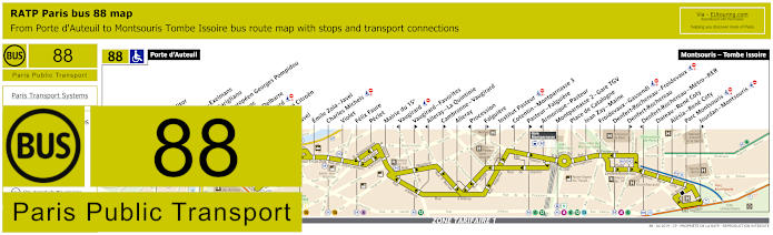
RATP Paris bus line 88 with stops, connections and street plan
However, the RATP Paris bus line 88 goes from Porte d'Auteuil through to Montsouris - Tombe Issoire and as you can see from the street maps and timetables, the nearest bus stop to Parc des Princes is the Porte Molitor stop, although you can utilise the Porte d'Auteuil stop as well, but this is slightly more convenient for getting to Hippodrome de Longchamp horse racing course, especially when they lay on a free shuttle service at certain times.
Paris bus line 88 stops:
Porte d'Auteuil, Porte Molitor, Exelmans, Versailles - Exelmans, Pont du Garigliano, Hopital Europeen Georges Pompidou, Rue Leblanc, Leblanc - Delbarre, Place Balard, Parc Andre Citroen, Cauchy, Javel, Emile Zola - Javel, Charles Michels, Violet, Felix Faure, Peclet, Mairie du 15e, Vaugirard, Vaugirard - Favorites, Alleray–La Quintinie, Cambronne - Vaugirard, Alleray, Procession, Falguiere, Institut Pasteur, Cotentin - Montparnasse 3, Pasteur - Falguiere, Montparnasse 2 - Gare TGV, Place de Catalogne, Jean Zay - Maine, Froidevaux - Gassendi, Denfert-Rochereau - Froidevaux, Denfert-Rochereau, Denfert-Rochereau - Metro - RER, Dareau - Rene Coty, Alesia - Rene Coty, Parc Montsouris, Jourdan - Montsouris, Montsouris - Tombe Issoire.
Paris bus line 88 main transport connections:
Metro Line: 4, 6, 8, 9, 10, 12, 13. Train Lines: B, C, N. Tram Line: T3a.
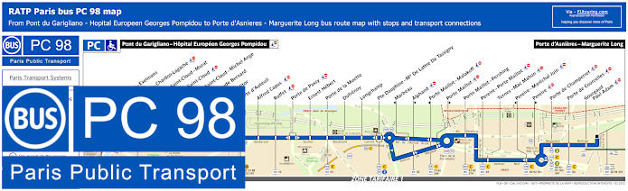
RATP Paris PC bus line 98 stops, connections and street plan
Although this shows the bus line PC also known as the bus line 98, which travels between Pont du Garigliano - Hopital Europeen Georges Pompidou and Porte d'Asnieres - Marguerite Long, and as you can see from the bus maps and timetables, this is one option for getting to the Palais des Congres entertainment and events centre, yet for the Parc des Princes football stadium you will find that the nearest stop is called Lycee Claude Bernard, which is only around a 200 metre walk from the Paris stadium.
Paris PC bus line 98 stops:
Pont du Garigliano - Hopital Europeen Georges Pompidou, Versailles - Exelmans, Versailles - Chardon-Lagache, Porte de Saint-Cloud - Murat, Porte de Saint-Cloud*, Porte de Saint-Cloud - Michel Ange, Lycee Claude Bernard, Porte Molitor, Porte d'Auteuil, Alfred Capus, Raffet, Porte de Passy, Ernest Hebert, Porte de la Muette, Dufrenoy, Longchamp, Pte Dauphine - Mal De Lattre de Tassigny, Marbeau*, Alphand**, Porte Maillot - Malakoff*, Porte Maillot**, Porte Maillot - Pershing, Pereire - Porte Maillot, Ternes - Mac Mahon, Pereire - Marechal Juin*, Pereire**, Porte de Champerret, Porte de Courcelles, Gourgaud - Paul Adam, Porte d'Asnieres - Marguerite Long.
* Stop served in direction of Pont du Garigliano - Hopital Europeen Georges Pompidou. ** Stop served in direction of Porte d'Asnieres - Marguerite Long.
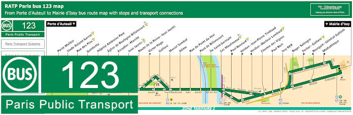
RATP Paris bus line 123 with stops, connections and street plan
As you can see from the bus line 123 maps and timetables this is one way for how to get to Stade Roland Garros where the French open tennis tournament is held, either via the bus stop of the same name or via the Porte Molitor bus stop, and either of these two stops will also get you within easy walking distance of the Parc des Princes football stadium and as they are located very close to each other in the 16th Arrondissement of Paris.
Paris bus line 123 stops:
Porte d'Auteuil, Porte Molitor, Stade Roland Garros, Rue des Pins, Gambetta, Hopital Ambroise Pare, Eglise de Boulogne-Billancourt, Escudier - Marche, Jean Jaures, Route de la Reine - Jean Jaures, Victor Hugo**, Gallieni, Marcel Sembat, Dome, Rue du Point du Jour, Pont de Billancourt, Ile Saint-Germain, Les Moulineaux, Paul Besnard**, Verdun - Jean-Pierre Timbaud**, Verdun - Docteur Lombard*, Chemin des Vignes, Paul Bert, Issy RER, Roger Salengro, Ferber - Gallieni**, Bourgain - General Gallieni*, Mediatheque**, Mairie d'Issy.
* Stop served in direction of Porte d'Auteuil. ** Stop served in direction of Mairie d'Issy.
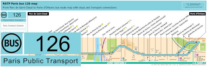
RATP Paris bus line 126 with stops, connections and street plan
Although the maps and timetables for bus line 126 shows the route going between Parc de Saint-Cloud and Porte d'Orleans and for getting to Parc des Princes you will find that the nearest bus stop is called the Marcel Sembat stop, yet we would like to point out that this is a walk of approximately 1400 metres from the football stadium.
Paris bus line 126 stops:
Parc de Saint-Cloud, La Colline**, Pont de Saint-Cloud - Rive Gauche**, Pont de Saint-Cloud - Albert Kahn, Rhin et Danube, Ancienne Mairie, Hotel de Ville de Boulogne-Billancourt, Marcel Sembat, Danjou, Rue du Point du Jour, Quai du Point du Jour, Issy - Val de Seine, President Robert Schuman, Victor Hugo, Corentin Celton, General de Gaulle, Place du Marechal de Lattre de Tassigny, Mairie de Vanves - Centre Administratif, Carrefour de l'Insurrection, Gare de Vanves - Malakoff, Gabriel Peri - Andre Coin, Pierre Larousse - Carrefour du 8 mai 1945, Pierre Brossolette - Gabriel Peri, Radiguey, Mairie de Montrouge, Cimetiere de Montrouge**, Gabrielle de Guerchy*, Porte d'Orleans.
* Stop served in direction of Parc de Saint-Cloud. ** Stop served in direction of Porte d'Orleans.
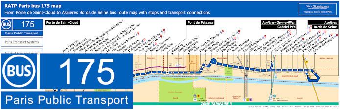
RATP Paris bus line 175 with stops, connections and street plan
Here you have the RATP bus line 175 that travels between Porte de Saint-Cloud and Asnieres - Bords de Seine, yet as you can see from the maps and timetables there are two other key stops of Pont de Puteaux and Asnieres - Gennevilliers - Gabriel Peri, but for Parc des Princes you would need the main terminus of Porte de Saint-Cloud.
Paris bus line 175 stops:
Porte de Saint-Cloud, Henri Martin, Rene Descartes, Marcel Sembat, Hotel de Ville de Boulogne-Billancourt, Ancienne Mairie, Rhin et Danube, Pont de Saint-Cloud - Albert Kahn, Pont de Saint-Cloud - Rive Gauche*, La Colline*, Parc de Saint-Cloud, Feudon, Parc de Bearn, L’ Aqueduc, Avenue de Longchamp, Rue du Val d’Or, Clavel, Pont de Suresnes, Nieuport, Pompidou, Pont de Puteaux, Godefroy*, Square Leon Blum, Soljenitsyne, Bellini*, RD7 - Pont de Neuilly, Paul Doumer, Victor Hugo, Mairie de Courbevoie, La Montagne, Pont Bineau, Franklin, Place Mermoz, Haussmann, Gare d’Asnieres, Gallieni, Mairie d’Asnieres, Place des Victoires - Marche, Voltaire - Lumieres, Asniers - Gennevilliers - Gabriel Peri, Place Voltaire, Marche de Gennevilliers, Cite Jardins, Gresillons - Felix Eboue, Tour d'Asnieres - L. Cely, Pierre Curie, Les Gresillons RER, Olympe de Gouges*, Asnieres - Bords de Seine.
* Only served in the direction of Porte de Saint-Cloud.
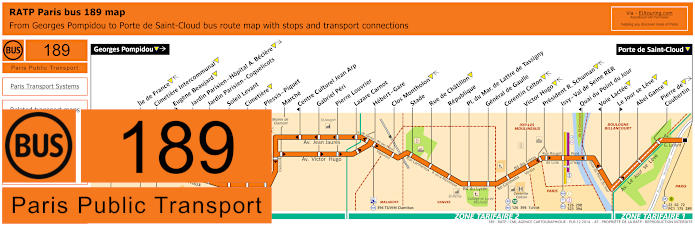
RATP Paris bus line 189 with stops, connections and street plan
Again, the closest bus stop to the Parc de Princes is the terminus of Porte de Saint-Cloud for the bus line 189 that travels through to Georges Pompidou, and as you can see from the maps and timetables, this travels from Paris itself in ticket tariff zone 1 through various communes, or areas of the Paris region, such as Vanves in zone 2 and Clamart in zone 3, so please this in mind if using this RATP bus route.
Paris bus line 189 stops:
Georges Pompidou, Ile de France, Cimetiere Intercommunal, Eugene Beaujard**, Jardin Parisien - Hopital A. Beclere, Jardin Parisien - Coquelicots, Soleil Levant, Cimetiere, Plessis - Piquet, Marche, Centre Culturel Jean Arp*, Gabriel Peri, Pierre Louvrier, Lazare Carnot, Hebert - Gare, Clos Montholon, Stade, Rue de Chatillon, Republique, Pl. du Mar. de Lattre de Tassigny, General de Gaulle, Corentin Celton, Victor Hugo, President R. Schuman, Issy - Val de Seine RER, Quai du Point du Jour*, Voie Lactee*, Le Jour se Leve**, Abel Gance, Pierre de Coubertin, Porte de Saint-Cloud.
* Stop served in direction of Georges Pompidou. ** Stop served in direction of Porte de Saint-Cloud.
Paris bus line 189 main transport connections:
Metro Lines: 9, 12. Train Line: C. Tram Lines: T2, T6. Bus Lines: 22, 62, 72, 126, 175, 189, 190, 289, 290, 323, 389, 390, 394, Clamibus (579), PC (98), TUVIM (589).
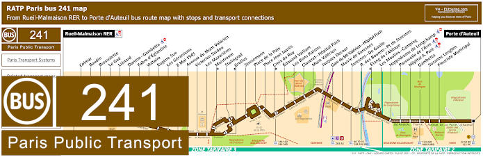
RATP Paris bus line 241 with stops, connections and street plan
Yet the RATP bus line 241 travels from Rueil-Malmaison RER through to Porte d'Auteuil, and it is this latter terminus that you would need for how to get to Parc des Princes football stadium, but as you can see from the maps and timetables, this is also an option for getting to Hippodrome de Longchamp horse racing course via a bus stop of the same name.
Paris bus line 241 stops:
Rueil-Malmaison RER, Colmar, Baudin, Brossolette, Le Gue, Lienard, Danton - Gambetta, Fabre d'Eglantine, Voltaire, Eugene Sue, Les Geraniums, 8 Mai 1945, Avenue du Mont Valerien, Victorien Sardou, Les Mazurieres, Maistrasse**, Stalingrad, Grotius*, Stresemann, Place de la Paix, Place Jean Jaures, Croix du Roy**, Edouard Vaillant, Les Bons Raisins, Cluseret - Hopital Foch, Mont Valerien, Jacques Decour, Gare du Mt Valerien - Hopital Foch, Mairie de Suresnes, Suresnes - De Gaulle, R. des Bourets - Pt de Suresnes, Etang de l'Abbaye*, Les Moulins - Camping, Hippodrome de Longchamp, Passerelle de l'Avre, Hopital A. Pare, Gambetta, Suzanne Lenglen, Fleuriste Municipal, Porte d'Auteuil.
* Stop served in direction of Rueil-Malmaison RER. ** Stop served in direction of Porte d'Auteuil.
Paris bus line 241 main transport connections:
Metro Line: 10. Train Lines: A, L, U. Bus Lines: 27, 32, 40, 52, 70, 88, 93, 98 (PC), 123, 144, 158, 160, 244, 260, 263, 360, 367, 460, 467, 4E, AS (544), SUBB (571).
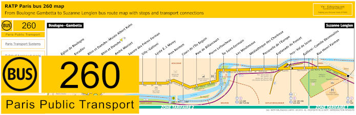
RATP Paris bus line 260 with stops, connections and street plan
But the bus line 260, also run by the transport company RATP, runs from Boulogne - Gambetta through to Suzanne Lenglen, and as you can see from the maps and timetables, it is actually the first terminus of Gambetta that would be required for getting to Parc des Princes, and this is an approximate walk of 1200 metres away from this Paris football stadium.
Paris bus line 260 stops:
Boulogne - Gambetta, Eglise de Boulogne, Escudier, Rhin et Danube - Musee Albert Kahn, Rhin et Danube, Andre Morizet, Square des Freres Farman, Silly - Gallieni, Lycee E. J. Marey, Yves Kermen, Cours de l'Ile Seguin, Parc de Billancourt, Pierre Lefaucheux, Ile Saint-Germain, Les Moulineaux, Mediatheque des Chartreux, Passerelle de l'Europe, Esplanade du Foncet, Issy - Val de Seine, Gallieni - Camille Desmoulins, Rue Henri Farman, Suzanne Lenglen.
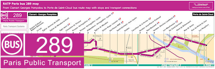
RATP Paris bus line 289 with stops, connections and street plan
However, this shows the maps and timetables for the RATP bus line 289, which travels between Clamart - Georges Pompidou and Porte de Saint-Cloud, and like several other bus routes, it is this latter terminus that will get you within easy walking distance of the Parc des Princes stadium.
Paris bus line 289 stops:
Clamart - Georges Pompidou, Espace Culturel Robert Doisneau, Le Lac, Eglise - Avenue de Celle, Eglise de Meudon-la-Foret, Tapis Vert, Cimetiere de Trivaux, Trivaux - Vertugadins**, Trivaux - Vertugadins - Lycee*, D'Alembert - Vertugadins - Lycee**, Eglise de Meudon*, Victor Hugo - Louvois, Val Fleury RER, Saint-Germain - Jean Jaures, Viaduc, Carrefour de la Ferme, Verdun - Jean-Pierre Timbaud**, Paul Besnard*, Verdun - Docteur Lombard**, Les Moulineaux, Ile Saint-Germain, Pont de Billancourt, Rue de Seine, Rue du Point du Jour, Les Peupliers, Porte de Saint-Cloud.
* Stop served in direction of Clamart - Georges Pompidou. ** Stop served in direction of Porte de Saint-Cloud.
Paris bus line 289 main transport connections:
Metro line: 9. Train line: C. Tram lines: T2, T6. Bus lines: 22, 42, 62, 72, 98 (PC), 123, 162, 169, 175, 189, 190, 260, 389, 390, TIM (569), TUVIM (589).
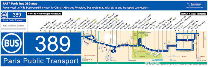
RATP Paris bus line 389 with stops, connections and street plan
Travelling from Hotel de Ville Boulogne-Billancourt, which is the stop you would need for getting to Parc des Princes, you will find that the RATP bus line 389 goes through to Clamart - Georges Pompidou with numerous bus stops on route, however, please take note of the maps and timetables carefully as some stops are only served in a particular direction.
Paris bus line 389 stops:
Hotel de Ville Boulogne-Billancourt, Silly - Gallieni, Lycee E.J. Maray, Billancourt, Yves Kermen, Cours de l’Ile Seguin, Parc de Billancourt, Place Jules Guesde, Traversiere, Pont de Billancourt, Ile Saint-Germain, Les Moulineaux, Paul Besnard, Verdun - Docteur Lombard, Verdun - Jean-Pierre Timbaud, Groupe Scolaire Brossolette, Gardes - Vaugirard, Meudon-sur-Seine, Gare de Bellevue, Jeanne d’Arc, Stalingrad, Rabelais, Eglise de Meudon, Trivaux - Vertugadins - Lycee, Cimetiere de Trivaux, Tapis Vert, Square Mederic, Acacias, Lycee de Villebon, Centre Cial du Moulin, Aerodrome Morane, Roseraie, Eglise - Avenue de Celle, Espace Culturel R. Doisneau, Le Lac, Pierre aux Moines, Centre Millandy, Patinoire, Paul Demange, Clamart - Georges Pompidou.
Paris bus line 389 main transport connections:
Train line: N. Tram lines: T2, T6. Bus lines: 123, 126, 169, 175, 189, 190, 260, 289, 389, 390, SUBB (571), TIM (569), TUVIM (589).
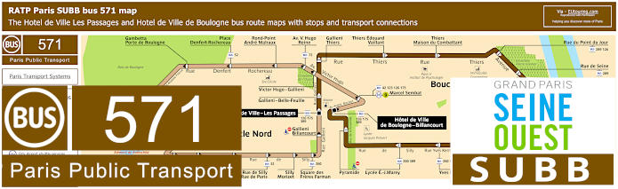
RATP Paris SUBB bus line 571 with stops, connections and street plan
So this shows the bus line SUBB, also known as bus line 571, and as you can see from the maps and timetables there are actually two circuits, therefore you have different options for getting to Parc des Princes with the dark brown bus route referred to as Boucle Sud, and the bus stop being Thiers Edouard Vaillant. Alternatively, you could utilise the light brown route called Boucle Nord and the bus stops called Place Denfert-Rochereau or Rond-Point Andre Malraux, which are both a little nearer to the football stadium at approximately 500 metres walk away.
Paris bus line 571 stops Boucle Nord:
Hotel de Ville de Boulogne, Marcel Sembat, Victor Hugo - Gallieni, Av. Victor Hugo - Reine, Rond-point Andre Malraux, Place Denfert-Rochereau, Gambetta - Porte de Boulogne, Alsace Lorraine, Hopital Ambroise Pare, Parchamp, Eglis de Boulogne, Parc Edmond de Rothschild, Dispensaire Saint-Denis, Saint-Denis - Anna Jacquin, Saint-Denis - Jean-Baptiste Clement, Rue de Silly - Rue de Paris, Silly - Morizet, Square des Freres Farman, Gallieni - Billancourt, Hotel de Ville - Les Passages.
Paris bus line 571 stops Boucle Sud:
Hotel de Ville - Les Passages, Gallieni - Belle-Feuille, Gallieni - Thiers, Thiers - Edouard Vaillant, Thiers - Maison du combattant, Rue du Point du Jour, Rue de Seine, Pont de Billancourt, Traversiere, Place Jules Guesde, Place Bir-Hakeim, Casteja, Yves Kermen, Lycee E. J. Marey, Pyramide, Hotel de Ville de Boulogne.
Paris bus line 571 main transport connections:
Metro Line: 9. Bus Lines: 42, 52, 72, 123, 126, 175, 260, 289, 389.
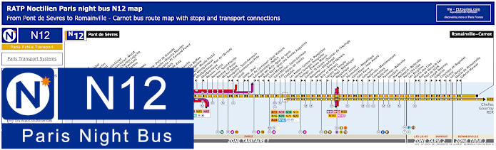
Paris Noctilien night bus N12 map with stops and transport connections
Noctilien are the night buses that run when other Paris public transport has stopped for the night, normally between the hours of around 12:30am through to 5:30am, and here you can see the maps and timetables for the Noctilien N12 bus line, which travels from Pont de Sevres to Romainville - Carnot. So for getting from Parc des Princes you would need the Porte de Saint-Cloud - Murat stop that goes in both directions including back into the centre of Paris, as the Porte de Saint-Cloud stop only goes out to Pont de Sevres.
Paris night bus line N12 stops:
Pont de Sevres, Billancourt, Marcel Sembat, Rene Descartes, Henri Martin, Porte de Saint-Cloud, Porte de Saint-Cloud - Murat, Versailles - Chardon Lagache, Versailles - Exelmans, Victorien Sardou, Wilhem, Pont Mirabeau, Degas, Radio France - Pont de Grenelle, Pont de Grenelle - Maurice Bourdet, Pont de Grenelle - Pl. Fernand Forest, Charles Michels, Avenue Emile Zola, Cambronne, Sevres - Lecourbe, Pasteur - Lycee Buffon, Pasteur - Falguiere, Armorique - Musee Postal, Gare Montparnasse, Montparnasse - Rue de l’Arrivee, Montparnasse, Rennes - Littre, Rennes - Saint-Placide, Rennes - D'Assas, Michel Debre, Bonaparte - Saint-Germain, Saint-Germain-des-Pres, Jacob, Seine - Buci, Pont du Carrousel - Quai Voltaire, Saint-Germain - Odeon, Pont des Arts - Quai de Conti, Pont Neuf - Quai des Grands Augustins, Saint-Michel, Saint-Michel - Saint-Germain, Cite - Palais de Justice, Chatelet, Les Halles - Centre Georges Pompidou, Centre Georges Pompidou, Turbigo - Etienne Marcel, Grenier St-Lazare - Quartier de l’Horloge, Reaumur - Sebastopol, Reaumur - Arts et Metiers, Arts et Metiers, Square du Temple, Turbigo - Republique, Republique, Ferry - Lenoir, Parmentier - Republique, Saint-Maur - Jean Aicard, Jules Ferry, Goncourt, Belleville - Menilmontant, Vouronnes, Belleville, Pyrenees - Belleville, Jourdain, Pixerecourt, Pelleport - Belleville, Porte des Lilas, Les Bruyeres, Mairie des Lilas, Rue de Noisy-le-Sec, Paul de Kock, Joseph Depinay, Gagarine, Cimetiere de Bagnolet, Floreal, Les Noyers, Mairie de Romainville, Gabriel Husson, Romainville - Carnot.
Paris night bus line N12 main transport connections:
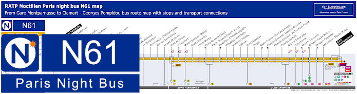
Paris Noctilien night bus N61 map with stops and transport connections
Just like above, when you look at the bus maps and timetables for Noctilien N61 night bus line, you will see that the Porte de Saint-Cloud stop travels in the direction of Clamart - Georges Pompidou having gone through several communes or areas to reach this terminus, whereas if you are leaving Parc des Princes and that area late wishing to travel back into Paris, you would need the Porte de Saint-Cloud - Murat stop that will take you in the direction of Paris Gare Montparnasse train station.
Paris night bus line N61 stops:
Clamart - Georges Pompidou, Espace Cultural R. Doisneau, Le Lac, Eglise - Avenue de Celle, Eglise de Meudon-la-Foret, Tapis Vert, Trivaux - Hangar Y, Trivaux - Vertugadins - Lycee, Eglise de Meudon, Rabelais, Stalingrad, Jeanne d'Arc, Gare de Bellevue, 11 Novembre, Brimborion - Division Leclerc, Parc de Saint-Cloud, Musee de Sevres, Pont de Sevres, Billancourt, Marcel Sembat - Metro, Rene Descartes, Henri Martin, Porte de Saint-Cloud**, Porte de Saint-Cloud - Murat, Versailles - Chardon Lagache*, Versailles - Exelmans, Victorien Sardou, Wilhem, Pont Mirabeau, Degas, Radio France - Pont de Grenelle*, Pont de Grenelle - Maurice Bourdet**, Pont de Grenelle - Place Fernand Forest, Charles Michels, Avenue Emile Zola, Cambronne, Sevres - Lecourbe**, Pasteur - Lycee Buffon**, Pasteur - Falguire*, Armorique - Musee Postal, Gare Montparnasse.
* Bus stop served in direction of Gare Montparnasse. ** Bus stop served in direction of Clamart - Georges Pompidou.
Paris night bus line N61 main transport connections:
Metro lines: 4, 6, 9, 10, 12, 13. Train line: N. Tram lines: T2, T6. Bus lines: N01, N02, N12, N13, N62, N63, N66, N122, N145.
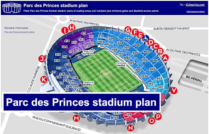
Parc des Princes football stadium plans of seating numbers, entrance gates and disabled access points
Here you can see a plan of the Parc des Princes stadium, which shows the four different stands and the different sections, or blocks, with the numbers in the 100s being closest to the pitch, and it is the Tribune Borelli, named after the former club chairman, Francis Borelli, which houses the player tunnel, the VIP area and the most expensive of seats in the stadium, often being referred to as the Presidential Tribune or Tribune Presidentielle in French, which is also where the TV and reporters gantry is located.
But for orientation, you will find the Tribune Boulogne is to the south and the Tribune Auteuil is to the north and all entrance gates, stadium seats etc are organised into an anti-clockwise pattern. Yet Parc des Princes is not just used as a football stadium, it has also hosted major Rugby matches and from time to time, even concerts, which have included the likes of Michael Jackson and The Rolling Stones that have performed here in the past.