Paris bus maps and timetables for bus lines 20 through to 29


Below you will find bus maps showing bus stops, transport connections, routes and timetables for Paris bus lines 20 through to 29, which are available in PDF and image file formats, as well as in large or small file sizes, making these ideal for any mobile device or home PC.

Paris bus maps - Central Bus Lines  01-09  10-19  20-29  30-39  40-49  50-59  60-69  70-79  80-89  90-99  100-109  110-119  120-129  130-139  140-149  150-159  160-169  170-179  180-189  190-199  200-209  210-219  220-229  230-239  240-249  250-259  260-269  270-279  280-289  290-299  300-309  310-319  320-329  330-339  340-349  350-359  360-369  370-379  380-389  390-399  400-409  420-429  430-439  440-449  450-459  460-469  470-479  480-489  490-499  500-509  510-519  520-529  530-539  540-549  550-559  560-569  570-579  580-589  590-599  610-619  620-629  700-709  Abeilles Buses  Batobus  Big Bus  DM Buses  Express A14  Fileo Buses CDG1  GO C Orly Shuttle Bus  Le Bus Direct  Magical Shuttle  OrlyBus  R4 Bus  RoissyBus  T'Bus CDG1  TICE Buses  Tootbus  TVM Bus  TZen Buses  Versailles Express  Vitavil  -  Noctilien Night Buses

Paris bus Express 20 map Gare de Meaux to CDG Airport with stops, connections and route plan

Paris Bus Express 20 map from CDG airport to Gare de Meaux
Here you have the Bus Express 20 line that is run by the company Transdev and goes from the Gare de Meaux through to the Gare Aeroport CDG1 / Roissypole, which runs every day of the week including holidays, as you will see from the timetables, and this line has a few stops on route such as Victor Drouet and Cite Technique in different communes or departments on the outskirts of Paris.

Paris bus Express 20 stops:


Gare Airport CDG1 - Roissypole, La Rosse, Victor Drouet, Les Tilleuls, Mairie*, Eglise*, Cite Technique, Gare de Meaux.

* Only served in a specific direction.

Paris bus Express 20 main transport connections:


Train Lines: B, P, TGV, CDG Val.
Bus lines: 02, 3A, 3B, 4, 4s, 8, 9, 10, 11, 12, 15, 18, 19, 21, 22, 23, 24, 32, 32za, 39, 43, 56, 63, 65, 67, 69, 93, 95-01, 95-02, 100, 349, 350, 351, 701, 702, 704, 711, 777, A, B, C, D, E, F, Fileo FO, Fileo G, Fileo S, Fileo SL, Fileo SP, Fileo T, Fileo VB, Fileo VE, Fileo O, Fileo V, G, H, I, K, Ks, N, Ns, N140, N141, N143, R4, RoissyBus, T'bus.

Paris bus Express 20 route maps CDG Airport available:


Paris Bus Express 20 map - PDF (standard quality - 0.511 MB)
Paris Bus Express 20 map - PDF (high quality - 1.018 MB)
Paris Bus Express 20 map - Image (standard quality - 0.425 MB)
Paris Bus Express 20 map - Image (high quality - 0.906 MB)

Paris bus Express 20 timetables Gare de Meaux to CDG Airport:


Paris Bus Express 20 timetables - PDF (1.224 MB)
Paris Bus Express 20 timetables - Image (2.761 MB)

RATP Paris bus line 20 map with stops, connections and street plan

Paris Bus line 20 map with stops and connections
This map shows the Paris Bus route for the RATP line 20 that travels between Loulson Bobet and Porte des Lilas with its additional bus stops on route like Gare Saint-Lazare, Opera, Bourse, Arts et Metiers, Republique and Belleville to name a few.

Paris bus line 20 stops:


Louison Bobet, Alsace**, Curnonsky*, Reims - Hotel des Impots*, Porte d’Asnieres - Marguerite Long, Juliette Lamber, Wagram - Pereire, Jouffroy d’Abbans - Malesherbes, Place du General Catroux, Malesherbes - Courcelles, Lisbonne - Mairie du 8e, Saint-Augustin, Gare Saint-Lazare*, Pasquier - Anjou*, Havre - Haussmann, Auber, Opera, Opera - Quatre Septembre**, Choiseul*, Richelie - Drouot*, Richelieu - Quatre Septembre**, Bourse**, Grands Boulevards*, Reaumur - Montmartre**, Poissonniere - Bonne Nouvelle*, Sentier**, Porte Saint-Denis*, Reaumur - Sebastopol**, Reaumur - Arts et Metiers**, Porte Saint-Martin*, Arts et Metiers**, Square du Temple**, Lancry - Saint-Martin*, Turbigo - Republique**, Republique - Magenta**, Republique, Ferry - Lenoir**, Jules Ferry*, Parmentier - Republique**, Goncourt*, Saint-Maur - Jean Aicard**, Belleville - Menilmontant**, Couronnes**, Faubourg du Temple - Piver*, Ramponeau**, Belleville, Julien Lacroix, Pyrenees - Belleville, Jourdain, Rue des Fetes, Pixerecourt, Pelleport - Belleville, Haxo, Porte des Lilas Metro, Porte des Lilas.

* Served in direction of Louison Bobet.
** Served in direction of Porte des Lilas.

Paris bus line 20 main transport connections:


Metro Lines: 2, 3, 3bis, 4, 5, 7, 8, 9, 11, 12, 13, 14.
Train Lines: A, E, J, L.
Tram Line: T3b.

Paris bus 20 route maps available:


RATP Bus Line 20 map - PDF (standard quality - 0.639 MB)
RATP Bus Line 20 map - PDF (high quality - 1.855 MB)
RATP Bus Line 20 map - Image (standard quality - 0.576 MB)
RATP Bus Line 20 map - Image (high quality - 1.031 MB)

Paris bus 20 timetables:


RATP Bus 20 timetables - PDF (0.433 MB)
RATP Bus 20 timetables - Image (1.195 MB)
Paris bus 22

RATP Paris bus 21 map with stops, connections and street plan

Paris bus line 21 map with stops and connections
Now the map above shows the Paris Bus route for the RATP line 21 that travels between Porte de Saint-Ouen-Hopital Bichat and Stade Charlety Porte de Gentilly, and has additional bus stops by famous tourist attractions like Opera, Pyramides, Palais Royal - Musee du Louvre, Rivoli - Pont Neuf, Chatelet, Luxembourg,  Port Royal - Berthollet, Daviel, Parc Montsouris, etc.

Paris bus line 21 stops:


Porte de Saint-Ouen - Hopital Bichat, Porte de Saint-Ouen, Navier, Guy Moquet, Davy, La Fourche, Ganneron, Place de Clichy, Liege, Gare Saint-Lazare - Budapest**, Trinite*, Gare Saint-Lazare - Havre**, Havre - Haussmann**, Haussmann - Mogador*, Auber**, Opera, Opera - 4 Septembre, Petits Champs - Danielle Casanova*, Pyramides, Palais Royal - Comedie Francaise**, Palais Royal - Musee du Louvre*, Saint-Honore - Valois**, Louvre - Rivoli, Rivoli - Pont Neuf*, Pont Neuf - Quai du Louvre**, Chatelet**, Rivoli - Chatelet*, Cite - Palais de Justice, Saint-Michel - Saint-Germain, Les Ecoles, Luxembourg, Saint-Jacques - Gay-Lussac, Feuillantines, Berthollet - Vauquelin, Port Royal - Berthollet, Glaciere - Arago, Glaciere - Nordmann, Glaciere - Auguste Blanqui, Daviel, Glaciere - Tolbiac, Parc Montsouris, Am. Mouchez Charbonnel*, Cite Universitaire**, Stade Charlety - Porte de Gentilly.

* Stop served in direction of Porte de Saint-Ouen - Hopital Bichat.
** Stop served in direction of Stade Charlety - Porte de Gentilly.

Paris bus line 21 main transport connections:


Metro Lines: 1, 2, 3, 4, 6, 7, 8, 9, 10, 11, 12, 13, 14.
Train Lines: A, B, D, E, J, L.
Tram Lines: T3a, T3b.

Paris bus 21 route maps available:


RATP Bus Line 21 map - PDF (standard quality - 0.620 MB)
RATP Bus Line 21 map - PDF (high quality - 1.774 MB)
RATP Bus Line 21 map - Image (standard quality - 0.565 MB)
RATP Bus Line 21 map - Image (high quality - 1.000 MB)

Paris bus 21 timetables:


RATP Bus 21 timetables - PDF (0.482 MB)
RATP Bus 21 timetables - Image (1.245 MB)

Paris bus line 21 map Gare de Fontainebleau Avon to Gare de St Fargeau with stops, connections and street plan

Paris bus line 21 Fontainebleau route map
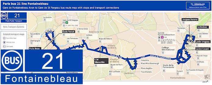
Here we have the bus line 21 run by Transdev that goes between Saint-Fargeau-Ponthierry and Avon travelling through different communes, or areas on its route including Chailly-en-Biere, Barbizon and Fontainebleau. Yet we would like to point out that as per the maps and timetables, several stops are only served at specific times or in a particular direction and there are also key stops for schools, etc, so please look at the information carefully.

Paris Fontainebleau bus line 21 stops:


Les Bouleaux, Les Chenes, Lycee Uruguay, Jacques Durand College la Vallee, Les Terrasses, Gare de Fontainebleau Avon, Lucien Cezard, Place de l'Etape, Chateau, College Internationnal, Dunant, La Fourche St Aspais, Stade de la Faisanderie, Cimetiere, Place Miss Greenough, Place Angelus, Trois Poiriers, RN7 La Poste, Route de Paris, Place de Villiers, Centre Commercial Villiers-en-Biere, Valbois, L'Orme Brise, Les Terrasses, Bas de Pringy, Avenue de Fontainebleau, Baticop, Place Tilly, Temploux, Ecole Fercot, Gare de St-Fargeau-Ponthierry, La Guiche, Faisanderie, Champagne, Puits Beau.

Paris Fontainebleau bus line 21 main transport connections:


Train Lines: D, R, TER.
Bus Lines: 1, 2, 3, 04, 4, 5, 6, 08, 9, 10, 21, 23, 112, 184-001, 184-014, 284-001, S10, S12, SAMOIS, TAD.

Paris Fontainebleau bus 21 route maps available:


Fontainebleau bus line 21 map - PDF (0.964 MB)
Fontainebleau bus line 21 map - Image (0.986 MB)

Paris Fontainebleau bus 21 timetables:


Fontainebleau bus 21 timetables - PDF (3.564 MB)
Fontainebleau bus 21 timetables - Image (3.898 MB)

RATP Paris bus 22 map with stops, connections and street plan

Paris Bus line 22 map with stops and connections
This map shows the Paris Bus route for the RATP line 22 that travels between Porte de Saint-Cloud and Gare Saint-Lazare, and has many different bus stops such as Jouvenet, Versailles - Exelmans, Pont Mirabeau, George Sand - La Fontaine, Place du Docteur Hayem - Radio France, Ranelagh, Trocadero, Charles de Gaulle - Etoile and Saint-Augustin.

Paris bus line 22 stops:


Porte de Saint-Cloud, Porte de Saint-Cloud - Murat, Versailles - Chardon-Lagache, Versailles - Exelmans**, Jouvenet*, Victorien Sardou**, Chardon-Lagache - Molitor*, Wilhem**, Pont Mirabeau**, Eglise d’Auteuil, George Sand - La Fontaine**, Perrichont*, Jasmin**, Theophile Gautier - Rue Gros*, Place du Docteur Hayem - Radio France*, Assomption - Radio France*, Ranelagh**, Les Vignes - Boulainvilliers RER*, La Muette - Boulainvilliers, Place Possoz, La Tour, Scheffer, Trocadero, Kleber - Boissiere, Kleber - Paul Valery, Charles de Gaulle - Etoile - Kleber, Charles de Gaulle - Etoile, Hoche - Saint-Honore, Friedland - Haussmann, Haussmann - Courcelles, Haussmann - Miromesnil, Saint-Augustin - La Boetie*, Saint-Augustin, Pasquier - Anjou*, Gare Saint-Lazare.

* Stop served in direction of Porte de Saint-Cloud.
** Stop served in direction of Gare Saint-Lazare.

Paris bus line 22 main transport connections:


Metro Lines: 1, 2, 3, 6, 9, 10, 12, 13, 14.
Train Lines: A, C, E, J, L.

Paris bus 22 route maps available:


RATP Bus Line 22 map - PDF (standard quality - 0.564 MB)
RATP Bus Line 22 map - PDF (high quality - 1.143 MB)
RATP Bus Line 22 map - Image (standard quality - 0.496 MB)
RATP Bus Line 22 map - Image (high quality - 0.866 MB)

Paris bus 22 timetables:


RATP Bus 22 timetables - PDF (0.474 MB)
RATP Bus 22 timetables - Image (1.215 MB)

Paris bus 22 map for CDG Airport to Gare de Villiers-le-Bel with stops, connections and street plan

Paris Bus 22 route map for CDG airport
Although here you can see the Transdev Bus Line 22, which runs from Gare de Villers-le-Bel - Gonesse Arnouville through to Aeroport CDG 1 Terminal 3 Roissypole with several bus stops in between such as Gonesse Hopital, Fontaine Cypierre, Eglise St Eloi and Aeroville, with the bus line travelling through different communes including Tremblay-en-France in the Paris region of Ile de France.

Paris bus line 22 CDG1 stops:


Gare de Villers-le-Bel - Gonesse Arnouville, Place de Lattre de Tassigny*, Place Sangnier*, Mairie Annexe La Fauconniere*, Square la Garenne**, Aristide Briand / General Durand, Chemin d'Ecouen, Salle des Fetes, Gonesse Hopital, Souvenir Francais, Arsonval, Cressonnieres, Fontaine Cypierre, Triangle de Gonesse, Les Mines, Charles de Gaulle, Eglise St Eloi, Aeroville, Marguilliers, Tour de Controle**, Aeroport CDG 1 - Terminal 3 Roissypole.

* Only served in direction of CDG Airport.
** Only served in direction of Gare de Villiers-le-Bel.

Paris bus line 22 CDG1 main transport connections:


Train Lines: B, D, CDGVal.
Bus lines: 11, 19, 20, 23, 24, 24sco, 25, 32, 32za, 35, 36, 37, 39, 43, 67, 93, 95.01, 95.02, 95.18, 95.B, 100, 250, 268, 270, 349, 350, 351, 370, 701, 702, Fileo, N140, N143, R4, Roissybus, T'bus.

Paris bus 22 CDG1 route maps available:


Paris Bus 22 CDG1 map - PDF (standard quality - 0.560 MB)
Paris Bus 22 CDG1 map - PDF (high quality - 1.083 MB)
Paris Bus 22 CDG1 map - Image (standard quality - 0.583 MB)
Paris Bus 22 CDG1 map - Image (high quality - 1.010 MB)

Paris bus 22 CDG1 timetables:


Paris Bus 22 CDG1 timetables - PDF (0.571 MB)
Paris Bus 22 CDG1 timetables - Image (1.570 MB)

Paris bus 22 map Versailles Gare des Chantiers to Bievres Burospace with stops and connections

Paris Phebus bus 22 map Versailles with stops and connections
So this is bus line 22 going to Versailles run by the transport company Phebus, which has a principal bus route from Bievres - Burospace to Versailles Gare des Chantiers - Abbe Rousseaux, although as you will see from the maps and timetables, the start is sometimes Velizy-Villacoublay - Pointe Ouest to Versailles Gare Rive Gauche or Lycee Jules Ferry, which is during school terms at specific hours, with some other stops also served as a secondary issue at specific times.

Paris bus 22 line stops:


Bievres - Burospace, Base Aerienne 107, Rond-Point - Val de Grace, Les Ailes, Les Helices, Route Militaire, General Valerie Andre, Zone Aeronautique, Pointe Ouest***, Echangeur, Petit Robinson**, Les Metz - La Mare*, Les Metz - Hoche*, Les Metz - Clair Bois*, Centre d'Affaires Petit Robinson*, Pont Colbert, Cisterciens, Sarraut, Ploix, Providence, Gare des Chantiers - Abbe Rousseaux, Vergennes*, Hotel de Ville* **, Gare de Versailles Rive Gauche*, Tournelles*, Bourdonnais*, Eveche*, Borgnis Desbordes* **, Lycee Jules Ferry*.

* Bus stops only served at specific times.
** Stop only served in direction of Bievres - Burospace.
*** A partial terminus stop.

Paris bus 22 main transport connections:


Train Lines: C, N, U.

Paris bus 22 Versailles route maps available:


Paris Bus 22 map - PDF (1.163 MB)
Paris Bus 22 map - Image (0.661 MB)

Paris bus 22 timetables Versailles to Bievres Burospace:


Paris Bus 22 timetables - PDF (1.032 MB)
Paris Bus 22 timetables - Image (2.426 MB)
Paris bus stop 24

Disneyland Paris bus 23 map Gare de Lagny Thorigny to Gare de Marne-la-Vallee Chessy Nord with stops, connections and street plan

Disneyland Paris bus 23 map with stops and connections
This bus line 23 provided by Transdev and AMV has over 35 stops, which travels primarily between Gare de Lagny Thorigny and Gare de Marne-la-Vallee Chessy Nord. Although this service runs all week, it does have a varying timetables for weekdays, weekends and holidays as well as day specific times, along with information on the Transilien P train times to and from Paris and Meaux, plus additional routes for specific locations and much more.

Disneyland Paris bus 23 line stops:


Gare de Lagny Thorigny, Verdun, Foch/Paix Notre Dame*, Foch*, St Joseph, Gallieni (Ets. St Laurent), Metz*, Pouzol, La Poste*, St Laurent (Rue Brebion)**, Lycee Van Dongen**, Rue Roger*, La Gendarmerie*, Coteaux RD 934, Alembert, Cabane Noire, Bonne Auberge, Mairie, Bicheret**, Puits du Gue**, Binaches**, Parc du Mont Evrain**, Bois de Loselet**, Sophora, Fontaine au Roi, Glaciere, Mairie de Chessy, Ecoles, Artisans*, Parking Nord, CAMSP, Santa Fe*, Sequoia Lodge*, Gare de Marne-la-Vallee Chessy Nord, St Eloi**, Louis Pasteur**, Chateau**, Vaillant**, Calvaire**.

* Stops served in specific directions only.
** Stops served only at select times.

Disneyland Paris bus 23 main transport connections:


Train lines: A, P.
Bus lines: 02, 04, 05, 07, 6, 12, 13, 15, 17, 19, 20, 21, 24, 25, 26, 29, 34, 35, 37, 38, 42, 43, 47, 50, 57, 59, 62, Magical Shuttle CDG, Magical Shuttle Orly, N130, N141.

Disneyland Paris bus 23 route maps available:


Disneyland Paris Bus 23 map - PDF (standard quality - 0.579 MB)
Disneyland Paris Bus 23 map - PDF (high quality - 1.116 MB)
Disneyland Paris Bus 23 map - Image (standard quality - 0.590 MB)
Disneyland Paris Bus 23 map - Image (high quality - 1.007 MB)

Disneyland Paris bus 23 timetables:


Disneyland Paris Bus 23 timetables - PDF (5.169 MB)
Disneyland Paris Bus 23 timetables - Image (5.682 MB)

Paris bus 23 map for CDG Airport to Villeparisis with stops, connections and street plan

Paris Bus 23 route map for CDG airport to Villeparisis
Here you can see the Bus 23 line run by the transport company Keolis, and as you can see from the timetables, this operates alongside the Fileo buses to provide a seamless 24 hour service to Charles de Gaulle Airport CDG 1 through to College Gerard Philipe in the commune on the outskirts of Paris called Villeparisis, which also travels through other areas including Tremblay-en-France and Mitry-Mory, with many different bus stops on route.

Paris bus line 23 stops:


Gare de Roissypole - Aeroport CDG 1 Gare, Terminal 2 - Route de Service, Rue des Vignes, Rue du Chapitre, Les Deux Cedres, Cargo Centre, Marguilliers, Aeroville, Aeroville Belle Borne, Rue de la Belle Borne*, Rue du Pave, Versant Seine, La Croix, Hub Postal, RD 88, Petit Tremblay, Saint-Peres*, Poste, Foyer des Bruyeres, Cruppet, IUT, Cottages, Pablo Neruda, Debussy, Mail des Droits de l'Homme, Diderot, Nelson Mandela**, Nantes*, Place Melun, Voltaire, Pasteur, Lamartine, Bibiliotheque CMCL, Gare de Villeparisis Mitry-le-Neuf, Chenes*, Poste*, La Plaine*, Centre Ville*, Kleber**, Aristide Briand**, Anatole France**, Buffon**, Pietrasanta**, Mairie de Villeparisis, Gymnase Aubertin, College Gerard Philipe.

* Bus stops served in direction of College Gerard Philipe.
** Bus stops served in direction of Aeroport CDG 1 Gare.

Paris bus line 23 CDG1 main transport connections:


Train Lines: B, CDG Val, TGV.
Bus lines: 1, 3, 3s, 8, 16, 18, 19, 20, 21, 22, 24, 27, 32, 32za, 39, 43, 67, 71, 93, 95-01, 95-02, 95-18, 100, 116, 171, 349, 350, 351, 619, 701, 702, R4, RoissyBus, T'bus 1, T'bus 2, T'bus 3, N41, N140, N143.

Paris bus 23 CDG1 route maps available:


Paris Bus 23 CDG1 map - PDF (standard quality - 0.637 MB)
Paris Bus 23 CDG1 map - PDF (high quality - 1.280 MB)
Paris Bus 23 CDG1 map - Image (standard quality - 0.631 MB)
Paris Bus 23 CDG1 map - Image (high quality - 1.098 MB)

Paris bus 23 timetables direction CDG Airport to Villeparisis:


Paris Bus 23 timetables CDG1 to Villeparisis - PDF (0.919 MB)
Paris Bus 23 timetables CDG1 to Villeparisis - Image (2.209 MB)

Paris bus 23 timetables direction Villeparisis to CDG Airport:


Paris Bus 23 timetables Villeparisis to CDG1 - PDF (0.975 MB)
Paris Bus 23 timetables Villeparisis to CDG1- Image (2.325 MB)

Paris bus 23 map Versailles Europe to Velizy-Villacoublay Velizy 2 with stops and connections

Paris Phebus bus 23 map Versailles with stops and connections
Here we have the Bus line 23 run by the transport company Phebus in conjunction with Keolis, which has a bus route between Europe, also known as the bus stop Versailles - Europe and Velizy-Villacoublay - Velizy 2, and as you will see from the maps and timetables there are several stops that are only served in a particular direction in addition to the fact that certain times are only applicable during the academic year.

Paris bus 23 line stops:


Versailles - Europe, Prefecture*, Hotel de Ville, Vergennes, Jean Mermoz, Octroi, Porchefontaine, Viroflay - Bertisettes, Cimetiere, Velizy-Villacoublay - Marcel Sembat, Robert Wagner, Picardie-Alsace, Picardie-Champagne, Centre Commercial Mozart, Savoie-Alsace, College Saint-Exupery, Robert Wagner, De Gaulle, Place de l'Aviation, Le Village*, Fronval**, Rabourdin*, Mairie-Tarron**, Villacoublay*, Mairie de Velizy**, Louvois**, Residence Les Bois*, Grange Dame Rose*, Exelmans**, Residence Europe*, Traite de Rome**, Europe Sud, Liaison Inovel Sud, Velizy 2 Sud*, Centre Commercial**, Velizy 2 Sud, Velizy 2.

* Served in the direction of Velizy-Villacoublay - Velizy 2.
** Served in the direction of Versailles - Europe.

Paris bus 23 main transport connections:


Tram Line: T6.
Bus Lines: 1, 2, 3, 4, 5, 6, 10, 13, 14, 15, 22, 23, 24, 31, 32, 33, 34, 35-36, 40, 45, 60, 91-08, 101, 105, 171, 179, 261, 262, 263, 291, 307, 379, 390, Express 9, Express 19.

Paris bus 23 Versailles route maps available:


Paris Bus 23 map - PDF (1.439 MB)
Paris Bus 23 map - Image (0.747 MB)

Paris bus 23 timetables from Versailles Europe to Velizy 2:


Paris Bus 23 timetables Versailles to Velizy 2 - PDF (1.747 MB)
Paris Bus 23 timetables Versailles to Velizy 2 - Image (3.844 MB)

Paris bus 23 timetables from Velizy 2 to Versailles Europe:


Paris Bus 23 timetables Velizy 2 to Versailles - PDF (1.701 MB)
Paris Bus 23 timetables Velizy 2 to Versailles - Image (3.742 MB)

RATP Paris bus 24 map with stops, connections and street plan

Paris bus 24 map with stops and connections
And this map shows the Paris Bus route for the RATP line 24 that travels between Pantheon and the Ecole Veterinaire de Maisons-Alfort, with many bus stops including Musee et Institut Curie, Les Gobelins, Gare d'Austerlitz, Van Gogh, Gare de Lyon, Bercy - Arena, Port aux Lions, Victor Hugo and more.

Paris bus line 24 stops:


Pantheon, Saint-Jacques - Gay-Lussac*, Musee et Institut Curie**, Feuillantines*, Ecole Normale Superieure**, Berthollet - Vauquelin, Monge - Claude Bernard, Les Gobelins*, Censier - Daubenton**, Saint-Marcel - Jeanne d’Arc*, Buffon - La Mosquee**, Saint-Marcel - La Pitie*, Buffon - Jardin des Plantes**, Gare d'Austerlitz, Gare d'Austerlitz - Cour Seine*, Quai de la Rapee**, Van Gogh*, Gare de Lyon - Maison de la RATP*, Gare de Lyon**, Ministere de l’Économie et des Finances, Gare de Bercy**, Bercy - Arena, Lachambeaudie**, Dijon - Lachambeaudie*, Baron Le Roy, Terroirs de France, Pont National - Quai de Bercy**, Centre Commercial, Port aux Lions, Pont Nelson Mandela, Les Berges de Charenton, Victor Hugo, Charenton-Ecoles, Edmond Nocard**, Pont de Charenton, Ecole Veterinaire de Maisons-Alfort.

* Served in direction of Ecole Veterinaire de Maisons-Alfort.
** Served in direction of The Pantheon.

Paris bus line 24 main transport connections:


Metro Lines: 1, 5, 6, 7, 8, 10, 14.
Train Lines: A, B, C, D, R.

Paris bus 24 route maps available:


RATP Bus Line 24 map - PDF (standard quality - 0.560 MB)
RATP Bus Line 24 map - PDF (high quality - 1.348 MB)
RATP Bus Line 24 map - Image (standard quality - 0.517 MB)
RATP Bus Line 24 map - Image (high quality - 0.909 MB)

Paris bus 24 timetables:


RATP Bus 24 timetables - PDF (0.497 MB)
RATP Bus 24 timetables - Image (1.289 MB)

Paris bus 24 map for CDG Airport to Compans with stops, connections and street plan

Paris Bus 24 route map from CDG airport to Ecole Jean de la Fontaine
Whereas here is another Bus 24 operated by transport company Keolis within the Paris region of Ile de France that travels from Ecole Jean de la Fontaine in the commune of Compans through to Aeroport CDG 1, which is also where the RER B train station is located for a direct connection to Paris. Also, as you will see from the plan and timetables, the bus route changes slightly in either direction, but line 24 also operates in conjunction with the Fileo buses that provide an out of hours service for continuity to the Airport and back.

Paris bus line 24 stops:


Gare de Roissypole - Aeroport CDG 1, Terminal 2 - Route de Service, Rue des Vignes, Rue du Chapitre, Les Deux Cedres, Cargo Centre, Marguilliers, Aeroville, Aeroville Belle Borne, Rue de la Belle Borne*, Rue du Pave, Versant Seine, La Croix, Hub Postal, Fulbert Lenfant, Paul Vaillant Couturier*, Mairie de Mitry-Mory*, Jean Moulin*, Parc de la Mairie**, Parc Corbrion**, Rue de Villeparisis**, Moulin a Vent, Andre Carrez, Freres Lumiere, Guy Moquet, Cheminots, Gare de Mitry-Claye, Vinci 2, CTCI, Caquot, Coulomb, Mercier, RD9, ZAC du Parc, Mairie de Compans, Calvaire, Ecole Jean de la Fontaine.

* Bus stops served in direction of Ecole Jean de la Fontaine.
** Bus stops served in direction of Aeroport CDG 1 Gare.

Paris bus line 24 CDG1 main transport connections:


Train Lines: B, CDG Val, K, TGV.
Bus lines: 3a, 3s, 9, 12, 16, 17, 18, 19, 20, 22, 23, 27, 32, 32za, 39, 43, 67, 93, 95-01, 95-02, 95-18, 100, 116, 349, 350, 351, 619, 701, 702, 756, R4, RoissyBus, T'bus 1, N140, N143.

Paris bus 24 CDG1 route maps available:


Paris Bus 24 CDG1 map - PDF (standard quality - 0.558 MB)
Paris Bus 24 CDG1 map - PDF (high quality - 1.094 MB)
Paris Bus 24 CDG1 map - Image (standard quality - 0.550 MB)
Paris Bus 24 CDG1 map - Image (high quality - 0.962 MB)

Paris bus 24 timetables direction CDG Airport to Compans:


Paris Bus 24 timetables CDG1 to Compans - PDF (0.709 MB)
Paris Bus 24 timetables CDG1 to Compans - Image (1.716 MB)

Paris bus 24 timetables direction Compans to CDG Airport:


Paris Bus 24 timetables Compans to CDG1 - PDF (0.666 MB)
Paris Bus 24 timetables Compans to CDG1- Image (1.647 MB)
Paris bus 28

Paris Phebus 24 bus map Versailles Gare des Chantiers to Velizy-Villacoublay with stops and transport connections

Paris Phebus bus 24 map Versailles with stops and connections
This Paris bus line 24 is run by the transport company Phebus who operate in the Paris region, and going from the commune of Versailles at the Gare des Chantiers - Abbe Rousseaux, this bus route travels through other communes or areas including Viroflay and Meudon, terminating at Centre Commercial in Velizy-Villacoublay. Additionally, as you can see on the map, there are some stops such as Roland Garros, Copernic and Exelmans that are only served in a specific direction of travel.

Paris Phebus 24 bus line stops:


Gare des Versailles Chantiers - Abbe Rousseaux, Vergennes, Jean Mermoz, Octroi, Porchefontaine, Bertisettes, Cimetiere, Mermoz, Roland Garros*, Bleriot*, Mairie-Tarron, Mairie de Velizy, Louvois, Exelmans*, Residence Europe, Grange Dame Rose, La Cheminee, Le Bois, Copernic*, Pasteur*, Marcel Daussault*, Dewoitine*, Velizy 2, Velizy Centre Commercial.

* Bus stops only served in a specific direction.

Paris Phebus 24 bus line main transport connections:


Train Lines: C, N, U.
Tram Line: T6.

Paris Phebus 24 bus Versailles route maps available:


Phebus 24 Bus Line map - PDF (standard quality - 0.383 MB)
Phebus 24 Bus Line map - PDF (high quality - 0.946 MB)
Phebus 24 Bus Line map - Image (standard quality - 0.336 MB)
Phebus 24 Bus Line map - Image (high quality - 0.592 MB)

Paris Phebus 24 bus timetables Versailles Gare des Chantiers to Velizy-Villacoublay:


Phebus 24 Bus timetables - PDF (1.170 MB)
Phebus 24 Bus timetables - Image (2.719 MB)

Disneyland Paris bus 24 map Gare de Marne-la-Vallee Chessy Nord to Jablines Ile de Loisirs with stops and connections

Disneyland Paris bus 24 map with stops and connections
This Paris bus line 24 is operated by Transdev and AMV and travels between Jablines - Ile de Loisirs and Gare de Marne-la-Vallee Chessy Nord, which is a short walk from Disneyland Paris. With different timetables for weekdays and weekends and holidays, along with a secondary route at specific times which misses a couple stops it is best to check in advance if using this service.

Disneyland Paris bus 24 line stops:


Jablines - Ile de Loisirs, Mairie, Mairie*, Charles de Gaulle*, Calvaire, Vaillant, Chateau, Louis Pasteur, St Eloi, Artisans**, Parking Nord, CAMSP, Santa Fe**, Sequoia Lodge***, Gare de Marne-la-Vallee Chessy Nord.

*Excluded on secondary route.
**Only served in direction Gare de Marne-la-Vallee Chessy Nord.
***Only served in direction Jablines - Ile de Loisirs.

Disneyland Paris bus 24 main transport connections:


Train line: A.
Bus lines: 6, 12, 13, 17, 19, 23, 34, 35, 38, 43, 47, 50, 57, 59, 62, Magical Shuttle CDG, Magical Shuttle Orly, N130, N141.

Disneyland Paris bus 24 route maps available:


Disneyland Paris Bus 24 map - PDF (standard quality - 0.428 MB)
Disneyland Paris Bus 24 map - PDF (high quality - 0.731 MB)
Disneyland Paris Bus 24 map - Image (standard quality - 0.458 MB)
Disneyland Paris Bus 24 map - Image (high quality - 0.778 MB)

Disneyland Paris bus 24 timetables:


Disneyland Paris Bus 24 timetables - PDF (2.935 MB)
Disneyland Paris Bus 24 timetables - Image (4.007 MB)

RATP Paris bus 25 map with stops, connections and street plan

Paris bus 25 map with stops and connections
The Paris Bus route RATP line 25 travels between Bibliotheque Francois Mitterrand and Vitry-sur-Seine - Duras, and during peak hours from Bibliotheque Francois Mitterrand to Vaillant-Couturier - Lenine, including stops such as Pont de Tolbiac, Watt and Victor Hugo - Bretagne.

Paris bus line 25 stops:


Bibliotheque Francois Mitterrand, Pont de Tolbiac, Thomas Mann, Watt, Bruneseau, Victor Hugo - Bretagne, Jules Vanzuppe, Vaillant-Couturier - Westermeyer**, Vaillant-Couturier - Lenine, Gambetta*, Maurice Gunsbourg* **, Rue de la Baignade* **, Vitry-sur-Seine - Duras*.

*Stops not served on a Saturday and remainder only served at specific times.
** Only served in a particular direction.

Paris bus line 25 main transport connections:
Metro Line: 14.
Train Line: C.

Paris bus 25 route maps available:


RATP Bus Line 25 map - PDF (standard quality - 0.434 MB)
RATP Bus Line 25 map - PDF (high quality - 1.125 MB)
RATP Bus Line 25 map - Image (standard quality - 0.431 MB)
RATP Bus Line 25 map - Image (high quality - 0.742 MB)

Paris bus 25 timetables:


RATP Bus 25 timetables - PDF (0.441 MB)
RATP Bus 25 timetables - Image (1.207 MB)

RATP Paris bus 26 map with stops, connections and street plan

Paris bus 26 map with stops and connections
Here you can see the map showing the Paris Bus route for the RATP line 26, which travels between Gare Saint-Lazare and Nation-Trone, and this has 34 different bus stops like St-Georges - Chateaudun, Square Montholon, Place Franz Liszt, Gare du Nord-Dunkerque, Louis Blanc, Marche Secretan, Atlas, Jourdain, Gambetta-Pyrenees, Orteaux, etc.

Paris bus line 26 stops:


Gare Saint-Lazare, Gare Saint-Lazare - Budapest*, Trinite, St-Georges - Chateaudun, Carrefour de Chateaudun, Chateaudun - Lamartine*, Cadet*, Maubeuge - Rochechouart*, Square Montholon*, Condorcet*, Place Franz Liszt*, Magenta - Maubeuge*, La Fayette - St-Quentin - Gare du Nord*, Gare du Nord - Dunkerque*, La Fayette - Dunkerque, Chateau Landon, Louis Blanc*, Jaures - Stalingrad*, Marche Secretan, Mathurin Moreau - S. Bolivar, Atlas, Botzaris - Buttes Chaumont, Pyrenees - Belleville, Jourdain, L'Ermitage, Pyrenees - Menilmontant, Villiers de l'Isle Adam, Gambetta - Pyrenees, Ramus, Pyrenees - Bagnolet, Orteaux, Maraichers, La Plaine, Cours de Vincennes, Marsoulan, Nation - Trone.

* Stop only served in a particular direction.

Paris bus line 26 main transport connections:


Metro Lines: 1, 2, 3, 3bis, 4, 5, 6, 7, 7bis, 9, 11, 12, 13, 14.
Train Lines: A, B, D, E, H, J, K, L, P.
Tram Lines: T3a, T3b.

Paris bus 26 route maps available:


RATP Bus Line 26 map - PDF (standard quality - 0.530 MB)
RATP Bus Line 26 map - PDF (high quality - 1.501 MB)
RATP Bus Line 26 map - Image (standard quality - 0.500 MB)
RATP Bus Line 26 map - Image (high quality - 0.899 MB)

Paris bus 26 timetables:


RATP Bus 26 timetables - PDF (0.431 MB)
RATP Bus 26 timetables - Image (1.185 MB)
Paris bus 24 Quai Anatole France

RATP Paris bus 27 map with stops, connections and street plan

Paris bus 27 map with stops and connections
Yet this map above shows the Paris Bus route for the RATP line 27 that travels between Gare Saint-Lazare and Porte d'Ivry, and this service has many different bus stops going to famous tourist attractions including places like Opera, Pyramides, Palais-Royal-Comedie Française, Musee du Louvre, Pont des Arts, Pont Neuf-Quai des Orfevres, Saint-Michel, Luxembourg, Monge-Claude Bernard, Les Gobelins, Place d'Italie-Mairie du 13, Nationale, Patay - Tolbiac, Porte de Vitry and several others.

Paris bus line 27 stops:


Gare Saint-Lazare, Havre - Haussmann, Auber, Opera, Opera - 4 Septembre, Petits Champs - D. Casanova*, Pyramides, Palais-Royal - Comedie Francaise, Musee du Louvre*, Quai Francois Mitterrand**, Pont du Carrousel - Quai Voltaire*, Pont des Arts**, Pont des Arts - Quai de Conti*, Pont Neuf - Quai du Louvre**, Pont Neuf - Quai des Orfevres**, Pt Neuf - Quai des Gds Augustins*, Pt St-Michel - Quai des Orfevres**, Saint-Michel*, Saint-Michel - Saint-Germain, Les Ecoles, Luxembourg, Saint-Jacques - Gay-Lussac, Feuillantines, Berthollet - Vauquelin, Monge - Claude Bernard, Les Gobelins, Banquier, Place d’Italie - Mairie du 13e, Place d’Italie - Auriol, Les Alpes, Nationale, Clisson, Jeanne d’Arc - Eglise de la Gare, Patay - Tolbiac, Oudine, Regnault, Massena - Darmesteter*, Porte de Vitry, Claude Regaud**, Porte d'Ivry.

* Stop served in direction of Gare Saint-Lazare.
** Stop served in direction of Porte d'Ivry.

Paris bus line 27 main transport connections:


Metro Lines: 1, 3, 4, 5, 6, 7, 8, 9, 12, 13, 14.
Train Lines: A, B, C, E, L, J.
Tram Line: T3a.

Paris bus 27 route maps available:


RATP Bus Line 27 map - PDF (standard quality - 0.578 MB)
RATP Bus Line 27 map - PDF (high quality - 1.186 MB)
RATP Bus Line 27 map - Image (standard quality - 0.538 MB)
RATP Bus Line 27 map - Image (high quality - 0.931 MB)

Paris bus 27 timetables:


RATP Bus 27 timetables - PDF (0.558 MB)
RATP Bus 27 timetables - Image (1.457 MB)

Paris bus 27 map for CDG1 Airport to Villiers-le-Bel with stops, connections and street plan

Paris Bus 27 route map from CDG airport to Puits de la Marliere
Here you can see the bus line 27 run by the transport company Keolis, which goes to Charles de Gaulle Airport 1 Train Station from Puits de la Marliere within the Villers-le-Bel commune in the Paris region also having stops in other areas of Gonesse and Roissy-en-France on its bus route. In addition, as you will see from the timetables and bus plan, there are certain bus stops only served in a specific direction, yet this line 27 also runs in conjunction with the Fileo buses.

Paris bus line 27 stops:


Gare de Roissypole - Aeroport CDG 1, Terminal 2 - Route de Service*, Rue des Vignes*, Rue du Chapitre*, Les 2 Cedres*, Cargo Centre*, Roissy - Zone Technique**, Entretien Nord, Convention, Airapolis, Orangerie, Vergers, Eglise de Roissy-en-France, Les Mines, Patte d'Oie, Cressonnieres, ZI Arsonval, Hopital, Salle des Fetes, Pierre Salvi, Jules Ferry, Place des Marronniers, Place Gaston Tessier, Rue Scribe**, Eugene Scibe*, Arthur Rimbaud, Louis Perrein, Pierre Semard, Jean Bullant, Tolinette, La Cerisaie, Eglise de Villiers-le-Bel, Les Lierres - Louis Michel*, Victor Hugo*, Les Lierres - D'Herivaux**, Henri Sellier, Puits de la Marliere.

* Stops served in the direction of Puits de la Marliere.
** Stops served in the direction of Aeroport CDG 1 Gare.

Paris bus line 27 CDG1 main transport connections:


Train Lines: B, CDG Val, TGV.
Bus lines: 19, 22, 32, 32za, 67, 95-02, 100C, 100P, 349, 350, 351, Express 20, Fileo FO, Fileo G, Fileo O, Fileo S, Fileo SP, Fileo VB, Fileo RS, RoissyBus.

Paris bus 27 CDG1 route maps available:


Paris Bus 27 CDG1 map - PDF (standard quality - 0.554 MB)
Paris Bus 27 CDG1 map - PDF (high quality - 1.099 MB)
Paris Bus 27 CDG1 map - Image (standard quality - 0.531 MB)
Paris Bus 27 CDG1 map - Image (high quality - 0.930 MB)

Paris bus 27 timetables direction CDG Airport to Villiers-le-Bel:


Paris Bus 27 timetables CDG1 to Villiers-le-Bel - PDF (1.261 MB)
Paris Bus 27 timetables CDG1 to Villiers-le-Bel - Image (2.977 MB)

Paris bus 27 timetables direction Villiers-le-Bel to CDG Airport:


Paris Bus 27 timetables Villiers-le-Bel to CDG1 - PDF (1.151 MB)
Paris Bus 27 timetables Villiers-le-Bel to CDG1- Image (2.682 MB)

RATP Paris bus 28 map with stops, connections and street plan

Paris bus 28 map with stops and connections
But this map shows the Paris Bus route for the RATP line 28 that travels between Porte de Clichy and Gare Montparnasse, and has 31 bus stops including Haussmann - Miromesnil, Rond-Point des Champs-Elysees-Roosevelt, Palais de la Decouverte, Pont des Invalides - Place de Finlande, Ecole Militaire, Hopital des Enfants Malades, Montparnasse and others.

Paris bus line 28 stops:


Porte de Clichy, Berthier - Rostropovitch, Rostropovitch - Pont Teresa, Pont Cardinet, Legendre, Rome - Batignolles, Europe, Gare Saint-Lazare - Rome, Saint-Augustin, La Boetie - Miromesnil, Haussmann - Miromesnil, Matignon - Saint-Honore, Saint-Philippe-du-Roule, Rond-Point des Champs-Elysees - Matignon, Rond-Point des Champs-Elysees - Roosevelt, Rond-Point des Champs-Elysees, Palais de la Decouverte, Pont des Invalides - Place de Finlande, La Tour Maubourg - Saint-Dominique, Invalides - La Tour Maubourg, Rue Cler, Ecole Militaire, Duquesne-Lowendal, El Salvador, Breteuil, Hopital des Enfants Malades, Maine - Vaugirard, Montparnasse - Alencon, Montparnasse - Rue de l'Arrivee, Montparnasse, Gare Montparnasse.

Paris bus line 28 main transport connections:


Metro Lines: 1, 2, 3, 4, 6, 8, 9, 10, 12, 13, 14.
Train Lines: C, E, J, L, N.
Tram Line: T3b.

Paris bus 28 route maps available:


RATP Bus Line 28 map - PDF (standard quality - 0.558 MB)
RATP Bus Line 28 map - PDF (high quality - 1.575 MB)
RATP Bus Line 28 map - Image (standard quality - 0.493 MB)
RATP Bus Line 28 map - Image (high quality - 0.883 MB)

Paris bus 28 timetables:


RATP Bus 28 timetables - PDF (0.456 MB)
RATP Bus 28 timetables - Image (1.164 MB)
Opera 21, 22, and 29 bus stop Rue Auber

RATP Paris bus 29 map with stops, connections and street plan

Paris bus 29 map with stops and connections
So this shows the Paris Bus route for the RATP line 29 that travels between Gare Saint-Lazare and the Porte de Montempoivre, which has numerous bus stops such as Opera, Bibliotheque Nationale, Louvre - Etienne Marcel, Centre Georges Pompidou, Place des Vosges, Bastille, Daumesnil-Diderot (Gare de Lyon) and many others. Although do keep in mind that this service only runs in the evening on Sundays from approximately 6pm or later depending on the time of year and at times before this, the route starts at Place des Vosges going to Porte de Montempoivre. Additionally, as you will see from the maps and timetables, several bus stops are only served in a particular direction.

Paris bus line 29 stops:


Gare Saint-Lazare, Havre - Haussmann, Auber, Opera, Opera - Quatre Septembre, Petits Champs - Danielle Casanova**, Richelieu - Quatre Septembre*, Bibliotheque Nationale**, Bourse*, Mairie du 2e*, Victoires, Louvre - Etienne Marcel**, Etienne Marcel - Montmartre, Turbigo - Etienne Marcel, Sebastopol - Etienne Marcel, Grenier St-Lazare - Quartier de l'Horloge, Centre Georges Pompidou*, Archives - Rambuteau*, Archives - Haudriettes**, Rue Vieille du Temple, Turenne - Saint-Gilles**, Payenne*, Place des Vosges*, Tournelles-Saint-Gilles**, Bastille - Beaumarchais, Bastille, Lyon - Ledru-Rollin*, Daumesnil - Ledru-Rollin**, Gare de Lyon - Diderot*, Daumesnil - Diderot (Gare de Lyon), Rambouillet, Charles Bossut, Mairie du 12e, Dubrunfaut, Daumesnil - Felix Eboue, Docteur Goujon - Reuilly, Picpus - Reuilly, Hopital Rothschild, Fabre d'Eglantine, Picpus, Docteur Netter, Porte de Saint-Mande, J. Lemaitre - M. Ravel*, Porte de Montempoivre.

* Served in direction of Porte de Montempoivre.
** Served in direction of Gare Saint-Lazare.

Paris bus line 29 main transport connections:


Metro Lines: 1, 3, 4, 5, 6, 7, 8, 9, 11, 12, 13, 14.
Train Lines: A, D, E, J, L, R.
Tram Line: T3a.

Paris bus 29 route maps available:


RATP Bus Line 29 map - PDF (standard quality - 0.629 MB)
RATP Bus Line 29 map - PDF (high quality - 1.829 MB)
RATP Bus Line 29 map - Image (standard quality - 0.571 MB)
RATP Bus Line 29 map - Image (high quality - 1.030 MB)

Paris bus 29 timetables:


RATP Bus 29 timetables - PDF (0.476 MB)
RATP Bus 29 timetables - Image (1.255 MB)