Paris bus maps and timetables for bus lines 50 through to 59


Listed below you will find the Paris bus maps showing bus stops, transport connections, routes and timetables for bus lines 50 through to 59, which are available in PDF and image file formats, as well as in large or small file sizes, making these ideal for any mobile device or PC.

Paris bus maps - Central Bus Lines  01-09  10-19  20-29  30-39  40-49  50-59  60-69  70-79  80-89  90-99  100-109  110-119  120-129  130-139  140-149  150-159  160-169  170-179  180-189  190-199  200-209  210-219  220-229  230-239  240-249  250-259  260-269  270-279  280-289  290-299  300-309  310-319  320-329  330-339  340-349  350-359  360-369  370-379  380-389  390-399  400-409  420-429  430-439  440-449  450-459  460-469  470-479  480-489  490-499  500-509  510-519  520-529  530-539  540-549  550-559  560-569  570-579  580-589  590-599  610-619  620-629  700-709  Abeilles Buses  Batobus  Big Bus  DM Buses  Express A14  Fileo Buses CDG1  GO C Orly Shuttle Bus  Le Bus Direct  Magical Shuttle  OrlyBus  R4 Bus  RoissyBus  T'Bus CDG1  TICE Buses  Tootbus  TVM Bus  TZen Buses  Versailles Express  Vitavil  -  Noctilien Night Buses

Disneyland Paris bus Express 50 map Chessy Gare Sud Quai E to Gare SNCF Quai 6 with stops and timetables

Disneyland Paris Bus Express 50 timetables and map
Run by transport company ProCars, the Bus Express 50 line goes from Provins - Gare SNCF Quai 6 to Chessy - Gare Sud Quai E, and as you will notice from the maps and timetables, there are different times depending upon the day of the week, although the service does run all year round. Yet sometimes referred to as Bus 50-1 you will see that there is a different start and end point at certain school times during weekdays, whereas bus 50-3 as the bus route express 50 is sometimes known as, only operates at weekends and on French holidays.

Disneyland Paris bus Express 50 line stops:


Provins Gare SNCF Quai 6, Ville Haute Quai 1*, Chenoise - Eglise*, Jouy-le-Chatel - Eglise*, Vaudoy - La Fontaine, Touquin - Place de la Mairie, Pezarches - Station de covoiturage, Chessy Gare Sud Quai E.

* Specific route served at certain hours during school terms

Disneyland Paris bus Express 50 main transport connections:


Train Lines: A, P.

Disneyland Paris bus Express 50 timetables and maps available:


Disneyland Paris Bus Express 50 timetables - PDF (0.913 MB)
Disneyland Paris Bus Express 50 timetables - Image (2.075 MB)

RATP Paris bus 52 map with stops, connections and route plan

Paris bus 52 map with stops and connections
This map shows the Paris Bus route for the RATP line 52 that travels between Parc de Saint-Cloud and the Opera-Rue Halevy, which is by the Palais Garnier Opera House, and has additional bus stops on route like Porte d'Auteuil, Jean Jaures, Denfert-Rochereau, Perrichont, Rodin, Lycee Janson de Sailly and Madeleine to name a few. Yet please note the timetables, as there are different times in one direction depending upon the time of year and of a late evening terminate at Charles de Gaulle - Etoile.

Paris bus line 52 stops:


Parc de Saint-Cloud, La Colline**, Pont de Saint-Cloud - Rive Gauche**, Pont de Saint-Cloud - Albert Kahn, Rhin et Danube - Metro, Rue de Silly, Rue de Billancourt, Jean Jaures, Rue de l'Est, Denfert-Rochereau, La Tourelle, Porte Molitor, Porte d'Auteuil, Gare d'Auteuil, Michel-Ange - Auteuil, Mozart - La Fontaine*, Eglise d'Auteuil**, George Sand - La Fontaine*, Perrichont**, Leopold II*, La Fontaine - Radio France**, Rodin**, Ranelagh**, Assomption - Radio France*, Les Vignes - Boulainvilliers*, La Muette - Boulainvilliers, Nicolo - Jean Richepin, Pompe - Mairie du 16e, Lycee Janson de Sailly, Place Jean Monnet, Bugeaud*, Victor Hugo - Poincare, Victor Hugo - Paul Valery, Charles de Gaulle - Etoile - Victor Hugo, Charles de Gaulle - Etoile, Hoche - Saint-Honore, Friedland - Haussmann, Haussmann - Courcelles, Saint-Philippe du Roule, La Boetie - Percier*, Matignon - Saint-Honore**, Haussmann - Miromesnil**, Saint-Augustin - La Boetie*, Saint-Augustin**, Anjou - Chaveau Lagarde, Madeleine - Malesherbes*, Madeleine, Capucines - Caumartin, Opera - Rue de la Paix**, Opera - Rue Halevy.

* Stop served in direction of Parc de Saint-Cloud.
** Stop served in direction of Opera - Rue Halevy.

Paris bus line 52 main transport connections:


Metro Lines: 1, 2, 3, 6, 7, 8, 9, 10, 12, 13, 14.
Train Lines: A, C.
Tram Line: T2.

Paris bus 52 route maps available:


RATP Bus Line 52 map - PDF (standard quality - 0.613 MB)
RATP Bus Line 52 map - PDF (high quality - 1.754 MB)
RATP Bus Line 52 map - Image (standard quality - 0.547 MB)
RATP Bus Line 52 map - Image (high quality - 0.976 MB)

Paris bus 52 timetables:


RATP Bus 52 timetables - PDF (0.486 MB)
RATP Bus 52 timetables - Image (1.308 MB)

RATP Paris bus 54 map with stops, connections and street plan

Paris bus 54 map with stops and connections
Yet this map shows the Paris Bus route for the RATP line 54 that travels between Gabriel Peri-Metro, Pigalle and Porte d'Aubervilliers with over 40 different bus stops that go to places like Danielle Casanova, Port de Clichy, La Fourche, Blanche, Pigalle, Anvers - Sacre-Coeur, Gare du Nord - Dunkerque, Quai de la Seine - Stalingrad, Crimee, Cambrai and many more.

Paris bus line 54 stops:


Gabriel Peri - Metro, Place Voltaire, Leon Blum, Danielle Casanova**, Landy - Martre*, Mairie de Clichy, Barbusse - Martre*, Jaures - Barbusse**, Victor Hugo - 8 Mai 1945*, Victor Hugo - Jean Jaures**, Porte de Clichy, Boulay, Brochant - Cardinet, Rue des Moines*, Legendre, La Fourche, Ganneron, Place de Clichy**, Place de Clichy - Caulaincourt*, Blanche, Pigalle, Rochechouart - Martyrs, Anvers - Sacre Coeur, Rochechouart - Clignancourt, Barbes - Rochechouart, Magenta - Maubeuge - Gare du Nord, La Fayette - Magenta - Gare du Nord**, Gare du Nord - Dunkerque*, Valenciennes*, Gare de l'Est, Verdun, Chateau Landon, Louis Blanc, Chaudron - Saint-Martin*, Quai de Seine - Stalingrad, Maroc - Flandre, Riquet, Crimee, Crimee - Archereau*, Crimee - Curial, Crimee - Rosa Parks, Flandre**, Cambrai**, Porte d’Aubervilliers - Macdonald, Porte d'Aubervilliers.

* Served in direction of Gabriel Peri - Metro.
** Served in direction of Porte d'Aubervilliers.

Paris bus line 54 main transport connections:


Metro Lines: 2, 4, 5, 7, 7bis, 12, 13.
Train Lines: B, C, D, E, H, K, P.
Tram Line: T3b.

Paris bus 54 route maps available:


RATP Bus Line 54 map - PDF (standard quality - 0.576 MB)
RATP Bus Line 54 map - PDF (high quality - 1.622 MB)
RATP Bus Line 54 map - Image (standard quality - 0.517 MB)
RATP Bus Line 54 map - Image (high quality - 0.923 MB)

Paris bus 54 timetables:


RATP Bus 54 timetables - PDF (0.453 MB)
RATP Bus 54 timetables - Image (1.199 MB)

Transdev Paris bus 54 map Porte de St Cloud to SNECMA Montereau with stops, connections and street plan

Paris bus 54 map with stops and connections
Run by Transdev and Senart Express this bus line travels between Paris - Porte de Saint-Cloud and SNECMA Montereau with 12 stops in either direction and only operates at specific times on a Monday to Friday. Though it is worth noting that a selection of these stops are not disabled friendly.

Transdev Paris bus 54 line stops:


Paris - Porte de Saint-Cloud, Michel Ange - Varize*, Versailles - Exelmans**, Victor - Pont de Garigliano, Place Balard, Porte de Versailles**, Porte de Plaisance, Porte de Brancion, Porte de Vanves, Porte de Chatillon, Porte d'Orleans (Ernest Reyer)*, Porte d'Orleans (BD Brune)**, SAFRAN Gare Routiere, Ecole des Mines, SNECMA Montereau.

* Only served in the direction of SNECMA Montereau.
** Only served in the direction of Paris - Porte de Saint-Cloud.

Transdev Paris bus 54 main transport connections:


Metro Lines: 4, 8, 9, 12, 13.
Train Line: C.
Tram Lines: T2, T3A.
Bus Lines: 10-20, 10-21, 22, 28, 38, 39, 42, 51, 55, 58, 62, 68, 72, 80, 88, 89, 95, 98 (PC), 108, 109, 125, 126, 128, 169, 175, 187, 188, 189, 191, 194, 197, 216, 289, 297, 299, 388, 475, 513, DM151, MontBus, N12, N13, N14, N21, N61, N62, N63, N66, N122, N145, Traverse, OrlyBus.

Transdev Paris bus 54 route maps available:


Transdev Paris Bus 54 map - PDF (standard quality - 0.638 MB)
Transdev Paris Bus 54 map - PDF (high quality - 1.637 MB)
Transdev Paris Bus 54 map - Image (standard quality - 0.656 MB)
Transdev Paris Bus 54 map - Image (high quality - 1.182 MB)

Transdev Paris bus 54 timetables:


Transdev Paris Bus 54 timetables - PDF (1.590 MB)
Transdev Paris Bus 54 timetables - Image (1.311 MB)
Paris RATP bus and Hotel de Ville

RATP Paris bus 56 map with stops, connections and street plan

Paris bus 56 map with stops and connections
And this map shows the Paris Bus route for the RATP line 56 that travels between Porte de Clignancourt and the Chateau de Vincennes, and some of the bus stops in between include Albert Kahn, Chateau Rouge, Magenta-Gare de l'Est train station, Strasbourg - Magenta, Republique, Oberkampf - Richard Lenoir, Chemin Vert, Nation - Voltaire, Aubert etc.

Paris bus line 56 stops:


Porte de Clignancourt, Mont-Cenis*, Albert Kahn, Simplon, Marcadet - Poissonniers, Chateau Rouge, Barbes - Rochechouart, Magenta - Maubeuge - Gare du Nord, La Fayette - Magenta - Gare du Nord, Magenta - Gare de l’Est, Strasbourg - Magenta*, Jacques Bonsergent, Republique - Magenta*, Republique, Republique - Voltaire, Jean-Pierre Timbaud, Oberkampf - Richard Lenoir, Saint-Ambroise, Chemin Vert, Voltaire - Leon Blum, Gymnase Japy, Charonne, Rue des Boulets, Voltaire - Montreuil, Nation - Voltaire, Nation - Trone, Picpus (Hopital Rothschild), Docteur Netter, Porte de Saint-Mande, Mairie de Saint-Mande, Aubert, Berault - Metro, Vignerons, Avenue du Chateau, Chateau de Vincennes.

* Bus stop is direction dependant.

Paris bus line 56 main transport connections:


Metro Lines: 1, 2, 3, 4, 5, 6, 8, 9, 11, 12.
Train Lines: A, B, D, E, H, K.
Tram Line: T3b.

Paris bus 56 route maps available:


RATP Bus Line 56 map - PDF (standard quality - 0.565 MB)
RATP Bus Line 56 map - PDF (high quality - 1.117 MB)
RATP Bus Line 56 map - Image (standard quality - 0.486 MB)
RATP Bus Line 56 map - Image (high quality - 0.971 MB)

Paris bus 56 timetables:


RATP Bus 56 timetables - PDF (1.421 MB)
RATP Bus 56 timetables - Image (1.314 MB)

Disneyland Paris bus 57 map Gare de Marne-la-Vallee to Gare d'Esbly with stops, connections and street plan

Disneyland Paris bus 57 and 57 Sco map with stops and connections
Bus line 57 and 57 Sco, run by Transdev in conjunction Marne et Morin travels mainly from Gare de Marne la Vallee Chessy and Gare d'Esbly. Line 57 runs all year, while the 57 Sco only runs on weekdays at specific times mainly to service College Louis Braille and does not run during school holidays or public holidays which are listed in the timetables.

Disneyland Paris bus 57 line stops:


Gare de Marne-la-Vallee Chessy Nord, Hotel Sequoia Lodge*, Hotel Santa Fe**, Hotels du Val de France, Cezanne, Peguy, Montaigne, Place de l'Europe*, Mairie**, Gare d'Esbly, College Louis Braille***, Beaux Regards***, Pomme d'Api***, Coeur de Pigeon***.

* Only served in the direction of Gare d'Esbly.
** Only served in the direction of Gare de Marne-la-Vallee Chessy.
*** Only served on specific secondary routes during the academic year.

Disneyland Paris bus 57 main transport connections:


Train lines: A, P.
Bus lines: 4, 4A, 4B, 6, 12, 13, 14, 17, 19, 23, 24, 34, 35, 38, 43, 47, 50, 59, 62, Ls, Magical Shuttle CDG, Magical Shuttle Orly, N130, N141.

Disneyland Paris bus 57 route maps available:


Disneyland Paris Bus 57 map - PDF (standard quality - 0.460 MB)
Disneyland Paris Bus 57 map - PDF (high quality - 1.285 MB)
Disneyland Paris Bus 57 map - Image (standard quality - 0.462 MB)
Disneyland Paris Bus 57 map - Image (high quality - 0.790 MB)

Disneyland Paris bus 57 timetables:


Disneyland Paris Bus 57 timetables - PDF (3.012 MB)
Disneyland Paris Bus 57 timetables - Image (3.330 MB)

RATP Paris bus 57 map with stops, connections and street plan

Paris bus 57 map with stops and connections
Here you can see the map showing the Paris Bus route for the RATP line 57, which travels between Arcueil - Laplace RER and Porte de Bagnolet - Louis Ganne, and again this has over 42 bus stops like Cite Verte, Division Leclerc - Mediatheque, Verdun, Place d'Italie - Bobillot, Rubens - Ecole des Arts et Metiers, Gare d'Austerlitz, Gare de Lyon - Diderot, Nation - Diderot and Stade Dejerine along with many others.

Paris bus line 57 stops:


Arcuil - Laplace RER, Maison des Examens RER**, Chaperon Vert*, Benoit Malon, Fraysse, Rue d’Arcueil**, Cite Verte**, Bout du Rang*, Reine Blanche*, Division Leclerc - Mediatheque**, Raspail - Jean Jaures*, Mairie de Gentilly**, Verdun - Victor Hugo**, Verdun*, Poterne des Peupliers, Abbe Georges Henocque, Bobillot - Tolbiac**, Moulin des Pres - Tolbiac*, Verlaine, Moulin des Pres**, Place d'Italie - Blanqui**, Place d'Italie - Bobillot*, Place d'Italie - Mairie du 13e, Rubens - Ecole des Arts et Metiers, Jenner - Jeanne d'Arc, Saint-Marcel - La Pitie, Gare d'Austerlitz, Gare d'Austerlitz - Cour Seine*, Van Gogh*, Quai de la Rapee**, Gare de Lyon - Diderot, Daumesnil - Diderot, Hopital Saint-Antoine, Reuilly - Diderot, Pierre Bourdan, Nation - Diderot, Nation - Taillebourg, Avron, Buzenval, Maraichers, Porte de Montreuil, Place de la Pte de Montreuil**, Stade Dejerine, Serpollet, Porte de Bagnolet - Louis Ganne.

* Served in direction of Porte de Bagnolet - Louis Ganne.
** Served in direction of Arcuil - Laplace RER.

Paris bus line 57 main transport connections:


Metro Lines: 1, 2, 3, 5, 6, 7, 8, 9, 10, 14.
Train Lines: A, B, C, D, R.
Tram Lines; T3a, T3b.

Paris bus 57 route maps available:


RATP Bus Line 57 map - PDF (standard quality - 0.628 MB)
RATP Bus Line 57 map - PDF (high quality - 1.773 MB)
RATP Bus Line 57 map - Image (standard quality - 0.561 MB)
RATP Bus Line 57 map - Image (high quality - 0.998 MB)

Paris bus 57 timetables:


RATP Bus 57 timetables - PDF (0.493 MB)
RATP Bus 57 timetables - Image (1.258 MB)
Paris RATP bus shelter and passengers

RATP Paris bus 58 map with stops, connections and street plan

Paris bus 58 map with stops and connections
This map above shows the Paris Bus route for the RATP line 58 that travels between Vanves - Lycee Michelet and Chatelet and this service has bus stops going to famous tourist attractions including Pont de la Vallee, Jean Moulin, Hopital Notre-Dame de Bon Secours, Gaite, Gare Montparnasse, Notre Dame des Champs, Raspail-Fleurus, Musee du Luxembourg, Theatre de l'Odeon and the Pont Neuf - Quai du Louvre plus several others.

Paris bus line 58 stops:


Vanves - Lycee Michelet, Carrefour Albert Legris***, Jean Jaures - Jean Bleuzen, Adolphe Pinard**, Pont de la Vallee, Porte de Vanves, Porte Didot - Lycee Raspail*, Porte de Chatillon*, Colonel Monteil**, Didot**, Jean Moulin*, Hopitaux Broussais et Saint-Joseph**, Hopital Notre-Dame de Bon Secours*, Alesia - Didot**, Alesia - Les Plantes*, Pernety**, Rue Benard*, Chateau**, Chateau - Mairie du 14e*, Losserand - Maine, Gaite***, Gare Montparnasse***, Montparnasse - Rue du Depart, Montparnasse - Cinemas*, Vavin, Brea - Notre-Dame-des-Champs*, Notre-Dame-des-Champs**, Raspail - Fleurus**, Fleurus**, Guynemer - Vavin* ***, Musee du Luxembourg***, Senat, Theatre de l'Odeon* ***, Saint-Germain - Odeon***, Mazarine*, Saint-Andre des Arts** ***, Pont Neuf - Quai des Gds Augustins, Saint-Michel**, Cite - Palais de Justice*, Pont Neuf - Quai du Louvre**, Chatelet - Q. de Gesvres**, Chatelet.

* Stop served in the direction of Vanves - Lycee Michelet.
** Stop served in the direction of Chatelet.
*** Not accessible to those with reduced mobility.

Paris bus line 58 main transport connections:


Metro Lines: 1, 4, 6, 7, 10, 11, 12, 13, 14.
Train Lines: A, B, C, D, N.
Tram Line: T3a.

Paris bus 58 route maps available:


RATP Bus Line 58 map - PDF (standard quality - 0.612 MB)
RATP Bus Line 58 map - PDF (high quality - 1.735 MB)
RATP Bus Line 58 map - Image (standard quality - 0.546 MB)
RATP Bus Line 58 map - Image (high quality - 0.963 MB)

Paris bus 58 timetables:


RATP Bus 58 timetables - PDF (0.489 MB)
RATP Bus 58 timetables - Image (1.255 MB)

Disneyland Paris bus 59 map Gare de Marne-la-Vallee to Gare de Crecy la Chapelle with stops, connections and street plan

Disneyland Paris bus 59 map with stops and connections
Bus line 59 is operated by Transdev and Marne et Morin, travelling between Gare de Marne-La-Vallee Chessy and Gare de Crecy-La-Chapelle. This bus route runs all year around, with different timetables for weekdays, Saturdays and Sundays plus holidays, yet we would like to point out that some stops are only served at specific times.

Disneyland Paris bus 59 line stops:


Gare de Marne-La-Vallee Chessy Nord, La Mare Houleuse, Les Genets, Truffaut, Rond Point RD436, Route de Melun, Mairie, Du Chene, Dainville, Sente du toit, Eglise, Passage a niveau, Gare de Villiers Montbarbin, Gare de Crecy-La-Chapelle, La Chapelle*, Camping*, Parrot World.

* Only served at specific times.

Disneyland Paris bus 59 main transport connections:


Train lines: A, P,TGV.
Bus lines: 6, 8A, 8Asco, 8B, 8C, 12, 13, 13A, 13B, 17, 18, 19, 23, 24, 34, 38, 42, 43, 50, 54, 57, 58, 62, 71, 73, L, Magical Shuttle CDG, Magical Shuttle Orly, N130, N141.

Disneyland Paris bus 59 route maps available:


Disneyland Paris Bus 59 map - PDF (standard quality - 0.518 MB)
Disneyland Paris Bus 59 map - PDF (high quality - 0.897 MB)
Disneyland Paris Bus 59 map - Image (standard quality - 0.526 MB)
Disneyland Paris Bus 59 map - Image (high quality - 0.887 MB)

Disneyland Paris bus 59 timetables:


Disneyland Paris Bus 59 timetables - PDF (3.835 MB)
Disneyland Paris Bus 59 timetables - Image (8.478 MB)

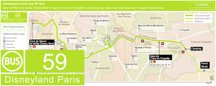
Disneyland Paris bus Express 59E map Gare de Marne-la-Vallee to Gare de Crecy la Chapelle with stops, connections and street plan

Disneyland Paris Bus Express 59E timetables and map
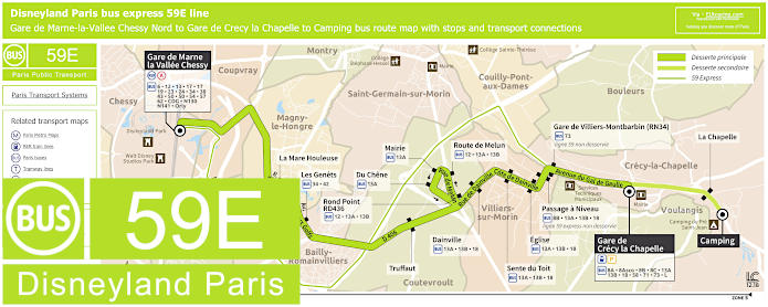
However, here we have the bus line 59E, also known as the bus Express 59, which travels between Gare de Crecy-la-Chapelle and Gare de Marne-la Vallee Chessy, yet as you can see from the map and timetables, this express bus route only has one stop in between at Gare de Villers Montbarbin (RN34) and operates at peak times on a Monday to Friday only.

Disneyland Paris bus Express 59E line stops:


Crecy-la-Chapelle - Gare de Crecy-la-Chapelle, Villiers-sur-Morin - Gare de Villiers Montbarbin (RN34), Chessy - Gare de Marne-la-Vallee Chessy Nord.

Disneyland Paris bus Express 59E main transport connections:


Train lines: A, P,TGV.
Bus lines: 6, 8A, 8Asco, 8B, 8C, 12, 13, 13A, 13B, 17, 18, 19, 23, 24, 34, 38, 43, 50, 54, 57, 58, 62, 71, 73, L, Magical Shuttle CDG, Magical Shuttle Orly, N130, N141.

Disneyland Paris bus Express 59E route maps and timetables available:


Disneyland Paris Bus 59E map and timetables - PDF (3.049 MB)
Disneyland Paris Bus 59E map and timetables - Image (3.353 MB)

RATP Paris bus 59 map with stops, connections and street plan

Paris bus 59 map with stops and connections
The last map showcases the Paris Bus route for RATP line 59 that travels between Gare de Clamart and Place d'Italie with stops such as Stade, Jean Jaures -Jean Bleuzen, Hopital Saint-Joseph, Place de Catalogne, Denfert-Rochereau, Les Gobelins and others to pick from.

Paris bus line 59 stops:


Gare de Clamart, Clos Montholon - Larmeroux, Stade, Rue de Chatillon, Diderot, Insurrection - Bleuzen, Jean Jaures - Jean Bleuzen, Adolphe Pinard, Pont de la Vallee, Porte de Vanves, Vercingetorix - Paturle, Hopital Saint-Joseph, Vercingetorix - Rouvier, Plaisance, Vercingetorix, Losserand - Gergovie, Pernety, Place de Catalogne, Jean Zay - Maine, Losserand - Maine, Froidevaux - Gassendi, Denfert-Rochereau - Froidevaux, Denfert-Rochereau, Arago - Saint-Jacques, Arago - Sante, Glaciere - Arago, Pascal, Les Gobelins, Banquier, Place d'Italie - Mairie du 13e, Place d'Italie.

Paris bus line 59 main transport connections:


Metro Lines: 4, 5, 6, 7, 13.
Train Lines: B, N.
Tram Line: T3a.

Paris bus 59 route maps available:


RATP Bus Line 59 map - PDF (standard quality - 0.533 MB)
RATP Bus Line 59 map - PDF (high quality - 1.527 MB)
RATP Bus Line 59 map - Image (standard quality - 0.502 MB)
RATP Bus Line 59 map - Image (high quality - 0.913 MB)

Paris bus 59 timetables:


RATP Bus 59 timetables - PDF (0.502 MB)
RATP Bus 59 timetables - Image (1.354 MB)