RATP bus maps and timetables for Paris bus lines 290 through to 299


Listed below are route maps showing bus stops, transport connections, street plans and timetables for the Paris bus lines 290 through to 299, which are available in image and PDF file formats, as well as in large or small sizes, making these ideal for download to any mobile device or home computer.

Paris bus maps - Central Bus Lines  01-09  10-19  20-29  30-39  40-49  50-59  60-69  70-79  80-89  90-99  100-109  110-119  120-129  130-139  140-149  150-159  160-169  170-179  180-189  190-199  200-209  210-219  220-229  230-239  240-249  250-259  260-269  270-279  280-289  290-299  300-309  310-319  320-329  330-339  340-349  350-359  360-369  370-379  380-389  390-399  400-409  420-429  430-439  440-449  450-459  460-469  470-479  480-489  490-499  500-509  510-519  520-529  530-539  540-549  550-559  560-569  570-579  580-589  590-599  610-619  620-629  700-709  Abeilles Buses  Batobus  Big Bus  DM Buses  Express A14  Fileo Buses CDG1  GO C Orly Shuttle Bus  Le Bus Direct  Magical Shuttle  OrlyBus  R4 Bus  RoissyBus  T'Bus CDG1  TICE Buses  Tootbus  TVM Bus  TZen Buses  Versailles Express  Vitavil  -  Noctilien Night Buses

RATP Paris bus line 290 with stops, connections and street plan

Paris bus 290 map with stops and connections
This first map above shows the Paris Bus route for the RATP line 290 that travels between La Boursidiere and Issy - Val de Seine RER, which has 22 additional bus stops in between such as the Parc de Sports, Parc Technologique, Jardin Parisien - Hopital Antoine Beclere, Place du Garde, Hopital Percy, Parc Henri Barbusse, to name a few of these.

Paris bus line 290 stops:


La Boursidiere, Reaumur, Pave Blanc, Newton**, Galilee, Langevin, Parc des Sports, Parc Technologique, Jardin Parisien - Hopital Antoine Beclere, Place du Garde, Marquis, Fleury, Hopital Percy, Epinettes, Defense - Egalite, Parc Henri Barbusse, Robespierre**, Andre Chenier**, Musee*, Mairie d'Issy, Marceau, President Robert Schuman, Gallieni - C. Desmoulins**, Issy - Val de Seine RER.

* Stop served in direction of La Boursidiere.
** Stop served in direction of Issy - Val de Seine RER.

Paris bus line 290 main transport connections:


Metro line: 12.
Train line: C.
Tram line: T2.
Bus lines: 123, 126, 169, 179, 189, 190, 323, 379, 390, 394, 395, 595, Clamibus (579), TUVIM (589).

Paris bus 290 route maps available:


RATP Bus Line 290 map - PDF (standard quality - 0.507 MB)
RATP Bus Line 290 map - PDF (high quality - 2.059 MB)
RATP Bus Line 290 map - Image (standard quality - 0.492 MB)
RATP Bus Line 290 map - Image (high quality - 1.069 MB)

Paris bus 290 timetables:


RATP Bus 290 timetables - PDF (0.419 MB)
RATP Bus 290 timetables - Image (1.090 MB)

RATP Paris bus line 291 with stops, connections and street plan

Paris bus 291 map with stops and connections
Now the map above shows the Paris Bus route for the RATP line 291, which goes from the Pont de Sevres in the Boulogne Billancourt area to Velizy 2 at the Avenue Morane on a Saturday and further on to Velizy - La Cheminee on the Rue Grange Dame Rose by the Bois de Meudon on a Monday to Friday with a few stops between like the Aerodrome Morane.

Paris bus line 291 stops:


Pont de Sevres, Ermitage de Villebon*, Aerodrome Morane, De Lattre de Tassigny**, Velizy 2, Dewoitine, Dassault, Le Bois, Velizy - La Cheminee.

* Stop served in direction of Pont de Sevres.
** Stop served in direction of Velizy - La Cheminee.

Paris bus line 291 main transport connections:


Metro line: 9.
Tram line: T6.
Bus lines: 15, 17, 20, 23, 24, 30, 34, 39.34, 40, 42, 45, 50, 60, 91.08, 160, 169, 171, 179, 307, 379, 389, 390, 426, 467, SUBB (571).

Paris bus 291 route maps available:


RATP Bus Line 291 map - PDF (standard quality - 0.419 MB)
RATP Bus Line 291 map - PDF (high quality - 1.579 MB)
RATP Bus Line 291 map - Image (standard quality - 0.415 MB)
RATP Bus Line 291 map - Image (high quality - 0.885 MB)

Paris bus 291 timetables:


RATP Bus 291 timetables - PDF (0.431 MB)
RATP Bus 291 timetables - Image (1.237 MB)
Paris RATP buses Place de la Madeleine

RATP Paris bus line 292 with stops, connections and street plan

Paris bus 292 map with stops and connections
Whereas this map shows the Paris Bus route for the RATP line 292, also known as Bus Express 292. that travels between Athis-Mons - Port de l'Essonne and Savigny-sur-Orge - ZAC Les Gatines - Capitaine Jean d'Hers with additional bus stops like Rue des Artistes, Carnot RER, plus several others. However, at certain times, you will see that the route only travels from College les Gatines through to Athis-Mons - Porte de l'Essonne stopping at less stops, many of which have additional connections such as Les Fleurs and Aristide Briand - Champagne.

Paris bus line 292 stops:


Athis-Mons - Porte de l'Essonne, Centre Sportif, Henri Barbusse, Maxime Vedy, Les Fleurs, Boulevard des Belges, Cimetiere du Plateau, Cite des Tilleuls, Place de la Republique, Les Bleuets, Aristide Briand - Champagne, Montagne Pavee, Rue des Artistes, Carnot RER, Centre Administratif, Salengro - Dunant, Marguerites - S. Allende, College Les Gatines, Meuniers, Pere Coindreau, Savigny-sur-Orge - ZAC Les Gatines - Capitaine Jean d'Hers.

Paris bus line 292 main transport connections:


Train line: C.
Tram line: T7.
Bus lines: 191.100, 285, 385, 399, 486, 487, 492, Athis Cars 8, DM8.

Paris bus 292 route maps available:


RATP Bus Line 292 map - PDF (standard quality - 0.465 MB)
RATP Bus Line 292 map - PDF (high quality - 1.829 MB)
RATP Bus Line 292 map - Image (standard quality - 0.443 MB)
RATP Bus Line 292 map - Image (high quality - 0.960 MB)

Paris bus 292 timetables:


RATP Bus 292 timetables - PDF (0.452 MB)
RATP Bus 292 timetables - Image (1.243 MB)

RATP Paris bus line 294 with stops, connections and street plan

Paris bus 294 map with stops and connections
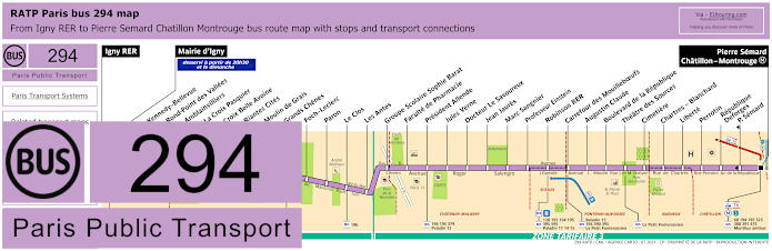
But this map shows the Paris Bus route for the RATP line 294 that travels from the Igny RER to Pierre Semard - Chatillon - Montrouge Metro, which has over 25 additional bus stops on route like the Groupe Scolaire Sophie Barat by the Foret de Verrieres, the Faculte de Pharmacie, Robinson RER, Carrefour des Mouilleboeufs, Boulevard de la Republique and the Theatre des Sources, etc. Although from 8:30pm and on Sundays this route instead starts at Marie d'Igny.

Paris bus line 294 stops:


Igny RER, Mairie d'Igny, Kennedy - Bellevue, Rond-Point des Vallees, Amblainvilliers, La Croix Pasquier, Croix Belle Avoine, Riantes Cites, Moulin de Grais, Grands Chenes, Foch - Leclerc, Paron, Le Clos, Les Antes, Groupe Scolaire Sophie Barat, Faculte de Pharmacie, President Allende, Jules Verne, Docteur Le Savoureux, Jean Jaures, Marc Sangnier, Professeur Einstein, Robinson RER, Carrefour des Mouilleboefs, Augustin Claude, Boulevard de la Republique, Theatre des Sources, Cimetiere, Chartres - Blanchard, Liberte, Perrotin, Republique - Deforges, Pierre Semard*, Pierre Semard - Chatillon - Montrouge.

* Stop served in direction of Igny RER.

Paris bus line 294 main transport connections:


Metro line: 13.
Train lines: B, C.
Tram line: T6.
Bus lines: 1, 16, 68, 128, 192, 194, 195, 196, 323, 388, 390, 391, 379, 390, 391, 395, 475, 595, Amibus (592), Baladin 15, Le Petit Fontenaisien (594), Montbus (526), Paladin 11 12 14 15.

Paris bus 294 route maps available:


RATP Bus Line 294 map - PDF (standard quality - 0.506 MB)
RATP Bus Line 294 map - PDF (high quality - 2.017 MB)
RATP Bus Line 294 map - Image (standard quality - 0.474 MB)
RATP Bus Line 294 map - Image (high quality - 1.024 MB)

Paris bus 294 timetables:


RATP Bus 294 timetables - PDF (0.543 MB)
RATP Bus 294 timetables - Image (1.371 MB)
Paris Bigbus tourists

RATP Paris bus line 297 with stops, connections and street plan

Paris bus 297 map with stops and connections
Yet this map shows the Paris Bus route for the RATP line 297, which travels between Antony RER and Longjumeau - Place Charles Steber with many additional bus stops on route like Pont d'Antony, Mairie de Wissous, Place de la Liberation, Chilly-Mazarin RER and Canal de l'Yvette although we would like to point out that certain stops are only served in a particular direction.

Paris bus line 297 stops:


Antony RER, Auguste Mounie - Division Leclerc*, Pont d'Antony, Descartes, Les Rabats, Pascal, Fribouli, Jumelages*, La Poste**, Montjean*, Cucheron, Mairie de Wissous, Mondetour*, Victor Baloche, Montavas, Vielle Remise, Cimetiere, College, Beauregard, Morangis Square Condorcet, Place de la Liberation, Division Leclerc, Elisee Reclus, Grand Jardin, Saint-Eloi, Chilly-Mazarin RER, Rue de Chilly, General de Gaulle, Leontine Sohier, Pasteur, Hop.de Longjumeau, Canal de l'Yvette, Longjumeau - Place Charles Steber.

* Stop served in direction of Antony RER.
** Stop served in direction of Longjumeau - Place Charles Steber.

Paris bus line 297 main transport connections:


Train lines: B, C, Orlyval.
Bus lines: 196, 199, 286, 299, 395, 399, 492, A, C, Circulaire G, D, E, Paladin 1 2 3 8 9 12 13.

Paris bus 297 route maps available:


RATP Bus Line 297 map - PDF (standard quality - 0.518 MB)
RATP Bus Line 297 map - PDF (high quality - 1.957 MB)
RATP Bus Line 297 map - Image (standard quality - 0.497 MB)
RATP Bus Line 297 map - Image (high quality - 1.072 MB)

Paris bus 297 timetables:


RATP Bus 297 timetables - PDF (0.575 MB)
RATP Bus 297 timetables - Image (1.623 MB)

RATP Paris bus line 299 with stops, connections and street plan

Paris bus 299 map with stops and connections
However, the last map and timetables in this section shows the Paris Bus route for the RATP line 299 and is classed as a Bus Express Line that travels from the Port d'Orleans - Ernest Reyer to Morangis - Place Lucien Boilleau, yet at specific times there is a route just from Longjumeau - Place Charles Steber to Morangis - Square Condorcet and another from Longjumeau - Leontine Sohier through to Chilly-Mazarin - Cimetiere.

Paris bus line 299 stops:


Porte d'Orleans - Ernest Reyer, Place de France, Les Freres Voisin, Concorde, ZAC du Perou, Rue des Fleurs, Route de Massy - Les Champarts, Cimetiere, College, Beauregard, Place de la Liberation, L'Avenir, Pierre Loti, Pierre Brossolette, Gabriel Fontaine, Mairie de Morangis*, Morangis - Place Lucien Boilleau.

* Only served in the direction of Porte d'Orleans - Ernest Reyer.

Bus 299 stops served at specific times:


Place de france, Les Freres Voisin, Concorde.

Paris bus line 299 main transport connections:


Metro line: M4.
Tram line: T3a.
Bus lines: 38, 68, 92, 107, 108, 109, 125, 128, 187, 188, 194, 197, 297, 388, 399, 475, 492, DM151, G.

Paris bus 299 route maps available:


RATP Bus Line 299 map - PDF (standard quality - 0.472 MB)
RATP Bus Line 299 map - PDF (high quality - 1.849 MB)
RATP Bus Line 299 map - Image (standard quality - 0.497 MB)
RATP Bus Line 299 map - Image (high quality - 1.068 MB)

Paris bus 299 timetables:


RATP Bus 299 timetables - PDF (0.438 MB)
RATP Bus 299 timetables - Image (1.321 MB)