RATP bus maps and timetables for Paris bus lines 570 through to 579


Listed below are route maps showing bus stops, transport connections, street plans and timetables for the Paris bus lines 570 through to 579, which are available in PDF and image formats, as well as in large or small sizes, making these ideal for download to any mobile device or home computer system.

Paris bus maps - Central Bus Lines  01-09  10-19  20-29  30-39  40-49  50-59  60-69  70-79  80-89  90-99  100-109  110-119  120-129  130-139  140-149  150-159  160-169  170-179  180-189  190-199  200-209  210-219  220-229  230-239  240-249  250-259  260-269  270-279  280-289  290-299  300-309  310-319  320-329  330-339  340-349  350-359  360-369  370-379  380-389  390-399  400-409  420-429  430-439  440-449  450-459  460-469  470-479  480-489  490-499  500-509  510-519  520-529  530-539  540-549  550-559  560-569  570-579  580-589  590-599  610-619  620-629  700-709  Abeilles Buses  Batobus  Big Bus  DM Buses  Express A14  Fileo Buses CDG1  GO C Orly Shuttle Bus  Le Bus Direct  Magical Shuttle  OrlyBus  R4 Bus  RoissyBus  T'Bus CDG1  TICE Buses  Tootbus  TVM Bus  TZen Buses  Versailles Express  Vitavil  -  Noctilien Night Buses

RATP Paris SUBB bus line 571 with stops, connections and street plan

Paris SUBB bus 571 map with stops and connections
This first map above shows the Paris Bus route for the RATP line 571, which is also known by other names like SUBB, Subb, Grand Paris Seine Ouest, Service Urbain de Boulogne-Billancourt and simply Line 571. Here there are two different circuits for this bus line called the Loop North (Boucle Nord) with stops like at the Paris tourist attractions of Place Denfert-Rochereau and Parc Edmond de Rothschild, etc, and Loop South (Boucle Sud) with stops at Place Bir-Hakeim and Lycee E J Marey, etc. Additionally, you will find that this is a free service to use.

Paris bus line 571 stops Boucle Nord:


Hotel de Ville de Boulogne, Marcel Sembat, Victor Hugo - Gallieni, Av. Victor Hugo - Reine, Rond-point Andre Malraux, Place Denfert-Rochereau, Gambetta - Porte de Boulogne, Alsace Lorraine, Hopital Ambroise Pare, Parchamp, Eglis de Boulogne, Parc Edmond de Rothschild, Dispensaire Saint-Denis, Saint-Denis - Anna Jacquin, Saint-Denis - Jean-Baptiste Clement, Rue de Silly - Rue de Paris, Silly - Morizet, Square des Freres Farman, Gallieni - Billancourt, Hotel de Ville - Les Passages.

Paris bus line 571 stops Boucle Sud:


Hotel de Ville - Les Passages, Gallieni - Belle-Feuille, Gallieni - Thiers, Thiers - Edouard Vaillant, Thiers - Maison du combattant, Rue du Point du Jour, Rue de Seine, Pont de Billancourt, Traversiere, Place Jules Guesde, Place  Bir-Hakeim, Casteja, Yves Kermen, Lycee E. J. Marey, Pyramide, Hotel de Ville de Boulogne.

Paris bus line 571 main transport connections:


Metro Line: 9.
Bus Lines: 42, 52, 72, 123, 126, 175, 260, 289, 389.

Paris bus 571 route maps available:


RATP SUBB Bus Line 571 map - PDF (standard quality - 0.512 MB)
RATP SUBB Bus Line 571 map - PDF (high quality - 1.709 MB)
RATP SUBB Bus Line 571 map - Image (standard quality - 0.533 MB)
RATP SUBB Bus Line 571 map - Image (high quality - 1.135 MB)

Paris bus 571 timetables:


RATP SUBB Bus 571 timetables - PDF (2.311 MB)
RATP SUBB Bus 571 timetables - Image (5.535 MB)

RATP Paris Navette Monastere bus line 572 with stops, connections and street plan

Paris Navette Monastere bus 572 map with stops and connections

Information below held for historical and archiving purposes


Now this map shows the Paris Bus route for the RATP line 572, which is also called Navette Monastere, Monast and Line 572. This bus service travels from Ville d'Avray - Monastere through to Sevres - Ville d'Avray - Gare SNCF Rive Droite and only has three bus stops in between which are called the Eglise de Vill d'Avray, Mairie and Jouet-Lucot, with the last two being close to the Parc de St-Cloud.

Paris bus line 572 stops direction Ville d’Avray - Monastere:


Sevres - Ville d’Avray - Gare SNCF Rive Droite, Jouet Lucot, Mairie, Eglise de Ville d’Avray, Monastere.

Paris bus line 572 stops direction Sevres - Ville d’Avray - Gare SNCF Rive Droite:


Monastere, Eglise de Ville d'Avray, Jouet Lucot, Sevres - Ville d’Avray - Gare SNCF Rive Droite.

Paris bus line 572 main transport connections:


Train Line: L.
Bus Lines: 426, 469, 471.

Paris bus 572 route maps available:


RATP Navette Monastere Bus Line 572 map - PDF (standard quality - 0.197 MB)
RATP Navette Monastere Bus Line 572 map - PDF (high quality - 0.813 MB)
RATP Navette Monastere Bus Line 572 map - Image (standard quality - 0.410 MB)
RATP Navette Monastere Bus Line 572 map - Image (high quality - 0.686 MB)

Paris bus 572 timetables:


RATP Navette Monastere Bus 572 timetables - PDF (1.301 MB)
RATP Navette Monastere Bus 572 timetables - Image (1.098 MB)
Paris tourist bus Pont Alexandre III

RATP Paris P'tit bus line 573 with stops, connections and street plan

Paris P'tit Bus 573 map with stops and connections
Although here we have the bus maps and timetables for the Paris bus line 573, which is referred to as P'tit Bus and P'tit Bus Le Pre Saint-Gervais, which runs in a loop from Marche - Mairie so certain stops are direction dependant, and this bus route goes to the areas of Pantin with the stop being Hoche and Les Lilas with one of the bus stops being called Mairie des Lilas.

Paris P'tit bus line 573 stops:


Marche - Mairie*, Marche Couvert, Danton - Brosselette, Jean Jaures, Cimetiere, Rue Gutenberg Baudin, Hoche - Metro, Gymnase Nodier, Stalingrad - Estienne d'Orves, Rue d'Estienne d'Orves, Mairie du Pre-Saint-Gervais, Hopital Robert Debre - Pre-St-Gervais, Les Marronniers, Belvedere - Sente des Marchais, Jean Jaures - Belvedere, Edouard Vaillant - Severine, Jacques Prevert - Edouard Vaillant, Convention, Les Bruyeres, Mairie des Lilas, Babylone.

Paris P'tit bus line 573 main transport connections:


Metro Lines: 5, 7bis, 11.
Tram Line: T3b.
Bus Lines: 48, 75, 105, 129, 151, 170, 330, 515 (Till Bus).

Paris P'tit bus 573 route maps available:


RATP P'tit Bus Line 573 map - PDF (standard quality - 0.483 MB)
RATP P'tit Bus Line 573 map - PDF (high quality - 1.607 MB)
RATP P'tit Bus Line 573 map - Image (standard quality - 0.483 MB)
RATP P'tit Bus Line 573 map - Image (high quality - 1.058 MB)

Paris P'tit bus 573 timetables:


RATP P'tit Bus 573 timetables - PDF (0.466 MB)
RATP P'tit Bus 573 timetables - Image (1.496 MB)

RATP Paris TUC bus line 574 with stops, connections and street plan

Paris TUC bus 574 map with stops and connections
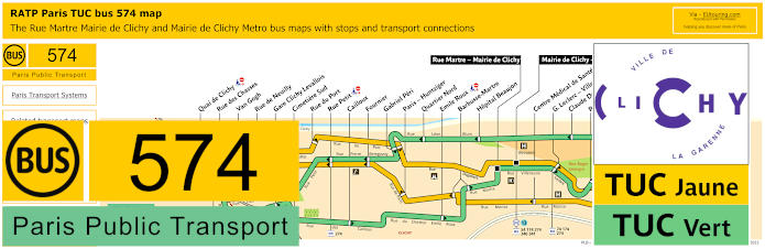
Whereas this map shows the Paris Bus route for the RATP bus line 574, which is also known as TUC short for Transport Urbain de Clichy-la-Garenne and there are two different circuits for this bus line which are called the TUC Jaune being the Yellow line, then you have the TUC Vert being the Green line.

Paris bus line 574 stops TUC Vert (Green line):


Rue Martre - Mairie de Clichy, G. Leclerc - Villeneuve - H. Beaujon, Republique - F. Mitterrand, Villeneuve, Palme Bigot, Rue des Trois Pavillons, Claude Debussy, Hopital Beaujon, Quartier Nord, Gabriel Peri, Fournier, Rue Petit, Rue de Neuilly, Gare Clichy Levallois, Cimetiere Sud, Cailloux, Emile Roux, Barbusse-Martre.

Paris bus line 574 main transport connections TUC Vert (Green line):


Bus Lines: 74, 174, 274, 341, TUC Jaune (574).

Paris bus line 574 stops TUC Jaune (Yellow line):


Mairie de Clichy - Metro, G. Leclerc - Villeneuve - H. Beaujon, Republique - F. Mitterrand, Victor Hugo - Sanzillon, Maison du Peuple, Centre Medical de Sante, Barbusse-Martre, Paris - Huntziger, Fournier, Rue Petit, Rue des Chasses, Quai de Clichy, Van Gogh, Rue du Porte, Gabriel Peri.

Paris bus line 574 main transport connections TUC Jaune (Yellow line):


Metro Line: 13.
Bus Lines: 54, 165, 174, 274, 340, 341, TUC Vert (574).

Paris bus 574 route maps available:


RATP TUC Bus Line 574 map - PDF (standard quality - 0.497 MB)
RATP TUC Bus Line 574 map - PDF (high quality - 1.677 MB)
RATP TUC Bus Line 574 map - Image (standard quality - 0.517 MB)
RATP TUC Bus Line 574 map - Image (high quality - 1.108 MB)

Paris bus 574 timetables:


RATP TUC Bus 574 timetables - PDF (0.448 MB)
RATP TUC Bus 574 timetables - Image (1.364 MB)

RATP Paris River Plaza bus line 577 with stops, connections and street plan

Paris River Plaza bus 577 map with stops and connections
And this map shows the Paris Bus route for the RATP line 577, which is also called Ligne River and River Plaza, that goes from Anieres - Gennevilliers - Gabriel Peri through to Gennevilliers RER and this has eight additional bus stops, which are River Plaza, Les Gresillons RER, Caboeufs, Olympe de Gouges to name a couple.

Paris bus line 577 stops:


Asnieres - Gennevilliers - Gabriel Peri, River Plaza, Pierre Boudou**, Tour d'Asnieres Laurent Cely*, Les Gresillons RER, Caboeufs*, Olympe de Gouges, Fosse Blanc, Moulin de Cage, Gennevilliers RER.

* Stop served in direction of Asnieres - Gennevilliers - Gabriel Peri.
** Stop served in direction of Gennevilliers RER.

Paris bus line 577 main transport connections:


Metro Line: 13.
Train Line: C.
Tram Line: T1.
Bus Lines: 54, 138, 166, 175, 177, 178, 235, 340, 366.

Paris bus 577 route maps available:


RATP River Plaza Bus Line 577 map - PDF (standard quality - 0.461 MB)
RATP River Plaza Bus Line 577 map - PDF (high quality - 1.430 MB)
RATP River Plaza Bus Line 577 map - Image (standard quality - 0.475 MB)
RATP River Plaza Bus Line 577 map - Image (high quality - 1.019 MB)

Paris bus 577 timetables:


RATP River Plaza Bus 577 timetables - PDF (0.365 MB)
RATP River Plaza Bus 577 timetables - Image (1.138 MB)
Paris RATP bus Place Charles de Gaulle

RATP Paris ClamiBus bus line 579 with stops, connections and street plan

Paris ClamiBus bus 579 map with stops and connections
Yet the last map for this section shows the Paris Bus route for the RATP line 579, also referred to as the ClamiBus that travels between the Maison de Quartier - Andre Charre and the Gare de Clamart, which has additional bus stops such as Place Aime Cesaire, Cimetiere Intercommunal, Gymnase du Jardin Parisien, Lycee Monod, Rue du Parc, Pont d'Amour - Hopital Percy, Place Hunebelle, Gymnase Condorcet and many more.

Paris bus line 579 stops:


Maison de Quartier - Andre Charre, Pasteur**, Maison de Quartier du Petit Clamart, Republique, Voltaire**, Bretagne**, Place Alme Cesaire**, Parc Auzelle, Cimetiere Intercommunal**, Champagne, Eugene Beaujard**, Jardin Parisien - Hopital Antoine Beclere, Rue du Parc, Gymnase du Jardin Parisien, Maison de Quartier de Jardin Parisien**, Soleil Levant, Cimetiere Communal, Lycee Monod, Savoie**, Paul Pade**, Pierre Corby**, Saint-Christophe**, Mairie, Place Hunebelle, Trosy, Marquis, Vallee du Bois, Jean Georget**, Fleury, Pont d'Amour - Hopital Percy, Gymnase Condorcet, Rue des Tricots**, Fleury - Tricots**, Gare de Clamart, Centre d'Arts Plastiques Albert Chanot*, Vallee du Bois Lily*, Hopital Ste-Emilie*, Marche*, Rue de Bievres*, Plessis Piquet*, Pierre Corby Fontenay*, Rue de Fontenay*, Gymnase du Fort*, Cimetiere*, Cite de la Plaine*, Ile de France*, Creche Normandie*, Gaite*.

* Stop served in direction of Maison de Quartier - Andre Charre.
** Stop served in direction of Gare de Clamart.

Paris bus line 579 main transport connections:


Train line: N.
Tram line: T6.

Paris bus 579 route maps available:


RATP ClamiBus Bus Line 579 map - PDF (standard quality - 0.664 MB)
RATP ClamiBus Bus Line 579 map - PDF (high quality - 1.470 MB)
RATP ClamiBus Bus Line 579 map - Image (standard quality - 0.721 MB)
RATP ClamiBus Bus Line 579 map - Image (high quality - 1.561 MB)

Paris bus 579 timetables:


RATP ClamiBus Bus 579 timetables - PDF (2.369 MB)
RATP ClamiBus Bus 579 timetables - Image (2.709 MB)