Paris Abeilles bus route maps and timetables


Below you can discover the street plan route maps and bus stops for Les Abeilles along with connections between both bus lines A and B that operate within the Levallois area on the outskirts of central Paris. In addition, you can see the bus timetables for Paris bus lines Les Abeilles, which are available in PDF and image file formats, making these ideal for download to any mobile device or PC.

Paris bus maps - Central Bus Lines  01-09  10-19  20-29  30-39  40-49  50-59  60-69  70-79  80-89  90-99  100-109  110-119  120-129  130-139  140-149  150-159  160-169  170-179  180-189  190-199  200-209  210-219  220-229  230-239  240-249  250-259  260-269  270-279  280-289  290-299  300-309  310-319  320-329  330-339  340-349  350-359  360-369  370-379  380-389  390-399  400-409  420-429  430-439  440-449  450-459  460-469  470-479  480-489  490-499  500-509  510-519  520-529  530-539  540-549  550-559  560-569  570-579  580-589  590-599  610-619  620-629  700-709  Abeilles Buses  Batobus  Big Bus  DM Buses  Express A14  Fileo Buses CDG1  GO C Orly Shuttle Bus  Le Bus Direct  Magical Shuttle  OrlyBus  R4 Bus  RoissyBus  T'Bus CDG1  TICE Buses  Tootbus  TVM Bus  TZen Buses  Versailles Express  Vitavil  -  Noctilien Night Buses

Abeilles bus line A route map with bus stops, street plan and timetables

Paris Abeilles bus line A map and timetables
In collaboration with RATP, the commune of Levallois operates a municipal transport called Les Abeilles, which is actually free to use for Levalloisiens, although it can be utilised by any person going to this area and operates daily including on French national holidays.

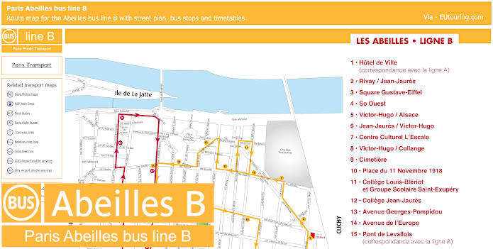
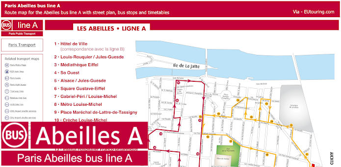
So here you can see the street maps for Les Abeilles A, which is the pink bus line that travels in a complete circuit with the start point being the Hotel de Ville, where you can also get a connection to Les Abeilles B, which is the same scenario for the Pont de Levallois bus stop.

Abeilles bus line A stops:
Hotel de Ville (correspondance avec la ligne B), Louis-Rouquier / Jules-Guesde, Mediatheque Eiffel, So Ouest, Alsace / Jules-Guesde, Square Gustave-Eiffel, Gabriel-Peri / Louise-Michel, Metro Louise-Michel, Place Marechal de-Lattre-de-Tassigny, Creche Louise-Michel, Danton / Louis-Rouquier, College Danton et Groupe scolaire Anatole-France, Institut Hospitalier Franco-Britannique (Hopital du Perpetuel Secours), Residence Greffulhe, Palais des Sports Marcel-Cerdan, Passerelle de l'Ile de la Jatte, Pont de Levallois (correspondance avec la ligne B), Rue Kleber (Police municipale), Metro Anatole-France / Place du General Leclerc, Conservatoire Maurice-Rave.

Paris Abeilles bus line A route maps available:
Abeilles bus line A map - PDF (2.768 MB)
Abeilles bus line A map - Image (1.703 MB)

Abeilles bus line B route map with bus stops, street plan and timetables

Paris Abeilles bus line B map and timetables
Whereas here you can see the bus maps and timetables for Les Abeilles B, or line B that is yellow in colour, and also travelling in a complete circuit starting at Hotel de Ville, which is the local city hall for the commune, you will see from the list of bus stops that this covers the opposite side of the area, and also runs year round, but at different times depending upon the day of the week and whether there are national holidays or school holidays.

Abeilles bus line B stops:


Hotel de Ville (correspondance avec la ligne A), Rivay / Jean-Jaures, Square Gustave-Eiffel, So Ouest, Victor-Hugo / Alsace, Jean-Jaures / Victor-Hugo, Centre Culturel L’Escale, Victor-Hugo / Collange, Cimetiere, Place du 11 Novembre 1918, College Louis-Bleriot et Groupe Scolaire Saint-Exupery, College Jean-Jaures, Avenue Georges-Pompidou, Avenue de l'Europe, Pont de Levallois (correspondance avec la ligne A), Anatole-France / Paul-Vaillant-Couturier, Parc de la Planchette, Paul-Vaillant-Couturier / Parc des Cinq continents, Place Jean-Zay / Pierre-Brossolette.

Paris Abeilles bus line B route maps available:


Abeilles bus line B map - PDF (2.742 MB)
Abeilles bus line B map - Image (1.651 MB)