RATP Paris bus line 303 with stops, connections and street plan
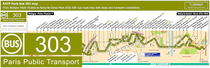
Whereas this map shows the Paris Bus route for the RATP line 303 that travels between Bobigny - Pablo Picasso and Noisy-le-Grand - Mont d'Est RER with over 40 additional bus stops including Rue des Peupliers, Lycees Vionnet - Renoir, Gare de Bondy RER, Avenue du Raincy, Gagny RER, Lycee Georges Clemenceau, Rue des Pommiers, Place de la Resistance and many, many more. However from 10pm and onwards there is a slightly different route taken for a section of this particular bus line.
Paris bus line 303 stops:
Bobigny - Pablo Picasso, Rene Camier*, Lamartine, Auguste Delaune*, Cite Administrative**, Rue des Peupliers, Pont de Bondy, Avenue de Rosny, Lycees Vionnet - Renoir, Eglise de Bondy, Blanqui - Salengro**, Blanqui - Carnot*, Baudin**, Edouard Vaillant - Carnot*, Gare de Bondy RER, Varsovie, L'Etoile, La Sabliere, Denis Papin, 8 Mai 1945, Les Marnaudes, Massena*, Meissonier**, Francois Coppee, Avenue du Raincy, Gustave Rodet, Pottier, Boulevard Andre, Gagny RER, Avenue Lucie*, Lycee Georges Clemenceau, Trois Communes, Cite des Bouleaux, Rue des Pommiers, Ile-de-France, Leon Blum, Cimetiere, Epi d'Or, Place de la Resistance, Rene Navier, Route de Neuilly, Eglise de Noisy-le-Grand*, Pasteur**, Mairie de Noisy-le-Grand*, Mairie de Noisy-le-Grand - Jean Vaquier**, Espace M. Simon, Republique, Noisy-le-Grand - Mont d'Est RER.
* Stop served in direction of Bobigny - Pablo Picasso.
** Stop served in direction of Noisy-le-Grand - Mont d'Est RER.
Paris bus 303 additional stops after 10:00 p.m. at end of service:
Cimetiere de Villemomble, Av. du Raincy, Chateau de Villemomble, Rue de Neuilly.
Paris bus line 303 main transport connections:
Metro line: 5.
Train lines: A, E.
Tram lines: T1, T4.
Bus lines: 8, 93, 120, 121, 134, 143, 146, 148, 206, 207, 221, 234, 251, 301, 306, 310, 320, 322, 334, 346, 604, 615, 616, 620, 623, TUB (546).
Paris bus 303 route maps available:
RATP Bus Line 303 map - PDF (standard quality - 0.731 MB)
RATP Bus Line 303 map - PDF (high quality - 2.665 MB)
RATP Bus Line 303 map - Image (standard quality - 0.694 MB)
RATP Bus Line 303 map - Image (high quality - 1.502 MB)
Paris bus 303 timetables:
RATP Bus 303 timetables - PDF (0.537 MB)
RATP Bus 303 timetables - Image (1.495 MB)