Paris bus maps and timetables for bus lines 30 through to 39


Listed below are the bus maps showing bus stops, transport connections, routes and timetables for the Paris bus lines 30 through to 39, which are available in both PDF and image file formats, as well as in large or small file sizes, making these ideal for any mobile device or home computer system.

Paris bus maps - Central Bus Lines  01-09  10-19  20-29  30-39  40-49  50-59  60-69  70-79  80-89  90-99  100-109  110-119  120-129  130-139  140-149  150-159  160-169  170-179  180-189  190-199  200-209  210-219  220-229  230-239  240-249  250-259  260-269  270-279  280-289  290-299  300-309  310-319  320-329  330-339  340-349  350-359  360-369  370-379  380-389  390-399  400-409  420-429  430-439  440-449  450-459  460-469  470-479  480-489  490-499  500-509  510-519  520-529  530-539  540-549  550-559  560-569  570-579  580-589  590-599  610-619  620-629  700-709  Abeilles Buses  Batobus  DM Buses  Big Bus  Express A14  Fileo Buses CDG1  GO C Orly Shuttle Bus  Le Bus Direct  Magical Shuttle  OrlyBus  R4 Bus  RoissyBus  T'Bus CDG1  TICE Buses  Tootbus  TVM Bus  TZen Buses  Versailles Express  Vitavil  -  Noctilien Night Buses

RATP Paris bus line 30 with stops, connections and route plan

Paris bus 30 map with stops and connections
This first map shows the Paris Bus route for the RATP line 30 that travels between Hopital Europeen Georges Pompidou and Pigalle with its additional bus stops on route that pass by famous locations like the Parc Andre Citroen, Tour Eiffel, Trocadero, Charles de Gaulle-Etoile-Kleber, Monceau, Place de Clichy, etc.

Paris bus line 30 stops:


Hopital Europeen Georges Pompidou, Rue Leblanc, Leblanc - Delbarre*, Place Balard, Parc Andre Citroen, Cauchy, Javel, Pont de Grenelle-Place Fernand Forest, Linois - Emeriau, Bibliotheque A. Chedid*, Bir-Hakeim, Tour Eiffel, Varsovie, Trocadero, Albert de Mun, Kleber - Boissiere, Kleber - Paul Valery, Charles de Gaulle - Etoile - Kleber, Charles de Gaulle - Etoile - Wagram, Ternes, Courcelles, Monceau, Malesherbes - Courcelles, Villiers, Rome - Batignolles, Turin - Batignolles, Place de Clichy, Place de Clichy - Caulincourt**, Blanche, Pigalle.

* Served in direction of Pigale.
** Served in direction of Hopital Europeen Georges Pompidou.

Paris bus line 30 main transport connections:


Metro Lines: 1, 2, 3, 6, 8, 9, 10, 12, 13.
Train Lines: A, C.
Tram Line: T3a.

Paris bus 30 route maps available:


RATP Bus Line 30 map - PDF (standard quality - 0.495 MB)
RATP Bus Line 30 map - PDF (high quality - 1.364 MB)
RATP Bus Line 30 map - Image (standard quality - 0.472 MB)
RATP Bus Line 30 map - Image (high quality - 0.828 MB)

Paris bus 30 timetables:


RATP Bus 30 timetables - PDF (0.484 MB)
RATP Bus 30 timetables - Image (1.256 MB)

RATP Paris bus line 31 with stops, connections and street plan

Paris bus 31 map with stops and connections
The map above shows the Paris Bus route for the RATP line 31 that travels between Charles de Gaulle - Etoile and Gare de l'Est, with additional bus stops like Ternes, Jouffroy d'Abbans - Malesherbes, Parc Martin Luther King, Guy Moquet, Marcadet - Poissonniers, Chateau Rouge, to name a few.

Paris bus line 31 stops:


Charles de Gaulle - Etoile, Charles de Gaulle - Etoile - Wagram**, Hoche - Saint-Honore*, Ternes, Wagram - Courcelles, Wagram - Prony, Jouffroy d'Abbans - Villiers, Jouffroy d'Abbans - Malesherbes, Jouffroy d'Abbans - Tocqueville, Pont Cardinet, Parc Martin Luther King**, Parc Martin Luther King*, Brochant - Cardinet, Moines - Davy, Guy Moquet, Vauvenargues, Damremont - Ordener, Duhesme - Le Ruisseau, Mairie du 18e - Jules Joffrin, Marcadet - Poissonniers, Chateau Rouge, Barbes - Rochechouart, Magenta - Maubeuge - Gare du Nord, La Fayette - Magenta - Gare du Nord, Gare de l'Est.

* Served in direction of Charles de Gaulle - Etoile.
** Served in direction of Gare de l'Est.

Paris bus line 31 main transport connections:


Metro Lines: 1, 2, 3, 4, 5, 6, 7, 12, 13, 14.
Train Lines: A, B, D, E, H, K, L, P.

Paris bus 31 route maps available:


RATP Bus Line 31 map - PDF (standard quality - 0.486 MB)
RATP Bus Line 31 map - PDF (high quality - 1.364 MB)
RATP Bus Line 31 map - Image (standard quality - 0.476 MB)
RATP Bus Line 31 map - Image (high quality - 0.832 MB)

Paris bus 31 timetables:


RATP Bus 31 timetables - PDF (0.481 MB)
RATP Bus 31 timetables - Image (1.302 MB)
Paris bus 38 Porte d'Orleans

RATP Paris bus line 32 with stops, connections and street plan

Paris bus 32 map with stops and connections
Now this map shows the Paris Bus route for the RATP line 32 that travels between Porte d'Auteuil and Gare de l'Est train station, and has over 48 different bus stops such as Porte de Passy, Ranelagh, La Tour, Trocadero, Iena, Matignon - Saint Honore, Saint-Augustin, Opera, Cadet, and Faubourg St-Denis to name a few.

Paris bus line 32 stops:


Porte d'Auteuil, Gare d’Auteuil**, Alfred Capus, Raffet, Porte de Passy, Louis Boilly**, Avenue Ingres*, La Muette - Boulainvilliers, Passy - Boulainvilliers**, Place de Passy**, Place Possoz*, Jean Bologne**, La Tour*, Passy - La Tour**, Scheffer, Trocadero, Albert de Mun, Iena, Marceau - P. 1er de Serbie - Pl. de Beyrouth, Pierre Charron - Francois 1er, La Boetie - Champs-Elysees, Rd-Pt des Champs-Elysees - Matignon**, Saint-Philippe du Roule*, Matignon - Saint-Honore**, Haussmann - Miromesnil**, La Boetie - Miromesnil*, Saint-Augustin, Pasquier - Anjou*, Gare Saint-Lazare**, Rome - Haussmann*, Havre - Haussmann**, Havre - Caumartin*, Auber, Opera**, Chaussee d'Antin*, Choiseul**, Le Peletier - Haussmann*, Richelieu - Drouot**, Carrefour Chateaudun*, Cadet*, Square Montholon*, Grands Boulevards**, Poissonniere - Bonne Nouvelle**, Hauteville*, Porte Saint-Denis**, Chateau d’Eau**, Faubourg - Saint-Denis*, Gare de l'Est.

* Stop served in direction of Porte d'Auteuil.
** Stop served in direction of Gare de l'Est.

Paris bus line 32 main transport connections:


Metro Lines: 1, 3, 4, 5, 6, 7, 8, 9, 10, 12, 13, 14.
Train Lines: C, E, J, L, P.

Paris bus 32 route maps available:


RATP Bus Line 32 map - PDF (standard quality - 0.586 MB)
RATP Bus Line 32 map - PDF (high quality - 1.660 MB)
RATP Bus Line 32 map - Image (standard quality - 0.527 MB)
RATP Bus Line 32 map - Image (high quality - 0.929 MB)

Paris bus 32 timetables:


RATP Bus 32 timetables - PDF (0.442 MB)
RATP Bus 32 timetables - Image (1.148 MB)

Paris bus 32 map for CDG Airport to Goussainville with bus stops and transport connections

Paris Bus 32 map from CDG airport to Victor Basch
Here you can see the bus Line 32 run by the transport company Keolis that operates in the Paris region, and going from Victor Basch in the Goussainville commune of Ile de France it travels through Roissy-en-France to Charles de Gaulle Airport CDG 1 Train station and further on to Aeroville at certain times, although we would like to point out that certain bus stops are only served depending upon direction of travel. Also as you will see from the bus 32 timetables, this line operates in conjunction with the Fileo buses to provide around the clock seamless connections to CDG Airport.

Paris bus line 32 CDG1 stops:


Victor Basch, Mairie de Goussainville, La Charmeuse, Les Montagnettes, Ecole Gabriel Peri, Acacias**, Camelinat**, Cachin Blatreux**, Henri Dunant**, Malcolm X**, Montgolfier, Chapellerie, Ampere/Chartrel, Avenue des Tilleuls, Centre de Secours, Stade Maurice Baquet, Marcel Cerdan**, Gare de Goussainville, Carrefour de l'Europe, Calvaire, Le Moulin, Pont Chinois, Les Charmilles, Chemin de St-Denis, Avenue Bocquet, La Talmouse, Roissy Parc, Passerelle, Village, Airapolis, Convention, Entretien Nord, Zone Technique, Gare de Roissypole - Aeroport CDG 1, Terminal 2 - Route de service*, Rue des Vignes*, Rue du Chapitre*, Les Deux Cedres*, Cargo Centre*, Marguilliers*, Aeroville*.

* Secondary extended route at specific times.
** Bus stops only served in a particular direction.

Paris bus line 32 CDG1 main transport connections:


Train Lines: B, CDG Val, D, TGV.
Bus lines: 11, 12, 12ZI, 19, 22, 23, 24, 27, 30B, 30D, 32za, 33, 39, 43, 93, 95-01, 95-02, 100C, 100P, 349, 350, 351, 701, 702, Express 20, Fileo FO, Fileo G, Fileo O, Fileo S, Fileo SP, Fileo VB, Fileo RS, Gbus, R4, R8, RoissyBus, T'bus 1.

Paris bus 32 CDG1 route maps available:


Paris Bus 32 CDG1 map - PDF (standard quality - 0.583 MB)
Paris Bus 32 CDG1 map - PDF (high quality - 1.151 MB)
Paris Bus 32 CDG1 map - Image (standard quality - 0.551 MB)
Paris Bus 32 CDG1 map - Image (high quality - 0.951 MB)

Paris bus 32 timetables direction CDG Airport to Goussainville:


Paris Bus 32 timetables CDG1 to Goussainville - PDF (2.539 MB)
Paris Bus 32 timetables CDG1 to Goussainville - Image (6.022 MB)

Paris bus 32 timetables direction Goussainville to CDG Airport:


Paris Bus 32 timetables Goussainville to CDG1 - PDF (2.561 MB)
Paris Bus 32 timetables Goussainville to CDG1- Image (6.061 MB)

Paris bus 32ZA map for CDG Airport to Gare de Goussainville with bus stops and transport connections

Paris Bus 32ZA map from CDG airport to Gare de Goussainville
Whereas this map shows the Bus route for the Bus Line 32.ZA from the Goussainville Train station through to Charles de Gaulle Airport CDG 1 Train station where you will find the RER B line, which is run by the transport company Keolis within Ile de France. Also, as you will see from the Bus 32.ZA timetables, highlighted in green it shows the approximate arrival and departure times for the RER D train going to and from Paris.

Paris bus line 32ZA stops:


Gare de Goussainville, Marcel Cerdan**, Carrefour de l'Europe, Calvaire, La Talmouse, Parc Mail 1*, Parc Mail 2*, Parc du Moulin*, Rue du Noyer*, Route de l'Arpenteur, Entretien Nord, Zone Technique, Gare de Roissypole - Aeroport CDG 1.

* Stop is in a different order depending upon direction of travel.
** Stop only served in the direction of Gare de Goussainville.

Paris bus line 32ZA CDG1 main transport connections:


Train Lines: B, D, CDG Val, TGV.
Bus Lines: 12, 12ZI, 19, 22, 23, 24, 27, 30B, 32, 39, 43, 93, 95.01, 95.02, 95.10, 100C, 100P, 349, 350, 351, 701, 702, Express 20, N140, N143, R4, R8, G'Bus, Fileo Buses, RoissyBus, T'Bus 1.

Paris bus 32ZA CDG1 route maps available:


Paris Bus 32ZA CDG1 map - PDF (standard quality - 0.464 MB)
Paris Bus 32ZA CDG1 map - PDF (high quality - 0.884 MB)
Paris Bus 32ZA CDG1 map - Image (standard quality - 0.426 MB)
Paris Bus 32ZA CDG1 map - Image (high quality - 0.747 MB)

Paris bus 32ZA CDG1 timetables:


Paris Bus 32ZA CDG1 timetables - PDF (0.564 MB)
Paris Bus 32ZA CDG1 timetables - Image (1.383 MB)
Paris bus 39 Gare du Nord

Disneyland Paris bus 34 map Gare de Marne-la-Vallee Chessy Nord to Gare de Val d'Europe with stops and connections

Disneyland Paris bus 34 map with stops and connections
This bus line 34 is operated by Transdev in conjunction with AMV runs primarily between Gare de Marne-la-Vallee Chessy Nord and Gare de Val d'Europe but also has other prominent starting and terminus points such as Place de l'Europe and Lycee Emilie du Chatelet among the 20 plus stops. It's worth noting that some of these stops are not disabled friendly, and the timetables show these as well as the different times between weekdays, weekends and holidays.

Disneyland Paris bus 34 line stops:


Gare de Marne-la-Vallee Chessy Nord (quai A)*, Sequoia Lodge** ***, Santa Fe****, Hotels du Val de France**, La Boucle des Trois Ormes**, Coulee Verte**, College Jacqueline de Romilly**, ZAC du Centre**, Cle des Champs**, La Boiserie**, Pre de Bray**, L'Orme Rond**, Les Genets**, Place de l'Europe, Gymnase, Bd des Artisans, Place de la Mairie***, CAT****, Marsange****, Ecole Les Girandoles, Rue de Bellesmes, Armieres, Centre Aquatique, Robert Thiboust**, Pressoir-Parc d'Entreprises**, Les Pleiades**, Place Thomas le Pileur**, Les Marmousets**, Garonne**, Hotel de Ville**, Lycee Emilie du Chatelet**, Gare de Val d'Europe.

* Not served on a few specific times during the academic year.
** Only served at specific times.
*** Only served in direction Gare de Val d'Europe.
**** Only served in direction Gare de Marne-la-Vallee Chessy Nord.

Disneyland Paris bus 34 main transport connections:


Train line: A.
Bus lines: 02, 6, 12, 13, 16, 17, 18, 19, 22, 23, 24, 32, 35, 38, 42, 43, 46, 47, 50, 57, 58, 59, 60, 62, 69, Magical Shuttle CDG, Magical Shuttle Orly, N130, N141.

Disneyland Paris bus 34 route maps available:


Disneyland Paris Bus 34 map - PDF (standard quality - 0.589 MB)
Disneyland Paris Bus 34 map - PDF (high quality - 1.546 MB)
Disneyland Paris Bus 34 map - Image (standard quality - 0.596 MB)
Disneyland Paris Bus 34 map - Image (high quality - 1.020 MB)

Disneyland Paris bus 34 timetables:


Disneyland Paris Bus 34 timetables - PDF (7.210 MB)
Disneyland Paris Bus 34 timetables - Image (6.415 MB)

Paris bus express 34 map Rue de l'Industrie Place de l'Ermitage to Quai Victor Hugo and Place Verdun with stops and connections

Paris Bus Express 34 Fontainebleau route map
Now here we have the bus line 34 run by the transport company Transdev, which is actually an Express bus line that travels between the areas of Melun and Chateau-Landon at Place Verdun, although as you will see from the maps and timetables there is a secondary route with a terminus of Piscine Egreville and some bus stops are only served in a particular direction or at certain times.

Paris Fontainebleau Bus Express 34 stops:


Melun - Rue de l'Industrie (terminus)*, Melun - Place de l'Emermitage (Depart)**, Place de l'Etape, Melun - Rue de l'Industrie (terminus)*, Melun - Place de l'Emermitage (Depart)**, Place de l'Etape, Fontainebleau - Chateau, Pave du Roy, Les Marechaux**, Cour des Adieux**, Les 4 Routes*, Les Fours**, Gare Carnot, Quai Victor Hugo, Hotel de Ville Bagneaux, Office du Tourisme, Gare Souppes****, Place du Marche, Chateau-Landon - Place Verdun, Egreville - Piscine Egreville***.

* Stop served in direction of Melun.
** Stop served in direction of Nemours Quai Victor Hugo, Chateau-Landon and Egreville.
*** Stop only served as a secondary route.
**** Not served during the morning on a Sunday or French holidays.

Paris Fontainebleau Bus Express 34 main transport connections:


Train Lines: D, R.
Bus Lines: 1, 2, 3, 4, 5, 7A, 7B, 7C, 7D, 8, 8B, 9, 9A, 9B, 9C, 9D, 10, 11A, 11B, 11C, 11D, 12, 13A, 13B, 13C, 14, 14A, 14B, 17A, 17B, 18, 18A, 18B, 18C, 21, 24, 30, 34, 37, 41, 46, 47, 208, A, C, Cd, D, E, F, Fd, G, L, N, T, V.

Paris Fontainebleau Bus Express 34 route maps available:


Fontainebleau bus exp 34 map - PDF (0.373 MB)
Fontainebleau bus exp 34 map - Image (1.004 MB)

Paris Fontainebleau Bus Express 34 timetables:


Fontainebleau bus exp 34 timetables - PDF (3.594 MB)
Fontainebleau bus exp 34 timetables - Image (3.034 MB)

Disneyland Paris bus 35 map Gare de Marne-la-Vallee to Bailly-Romainvilliers with stops, connections and street plan

Disneyland Paris bus 35 map with stops and connections
Run again by Transdev and AMV this Paris bus line 35 starts and finishes at Gare de Marne-la-Vallee Chessy Nord, just a short distance from the Disneyland Paris park. With over ten different stops, this service runs on weekdays, but not on holidays or weekends, yet as you look at the bus map and timetables we would like to point out that there are only certain bus stops served in both directions as it goes round in a loop back to the train station.

Disneyland Paris bus 35 line stops:


Gare de Marne-la-Vallee Chessy Nord, Sequoia Lodge*, Santa Fe**, Circulaire-Magny, Rue du Moulin a Vent, Les 3 Petits Bois, Le Verger, L'Orme Rond, Les Genets, Place de l'Europe, Gymnase, Bd des Artisans, Place de la Mairie, Ecole Les Girandoles, Rue de Bellesmes.

* Only served in the outgoing direction.
** Only served in the return direction.

Disneyland Paris bus 35 main transport connections:


Train line: A.
Bus lines: 6, 12, 13, 17, 19, 23, 24, 34, 38, 43, 47, 50, 57, 59, 62, Magical Shuttle CDG, Magical Shuttle Orly, N130, N141.

Disneyland Paris bus 35 route maps available:


Disneyland Paris Bus 35 map - PDF (standard quality - 0.448 MB)
Disneyland Paris Bus 35 map - PDF (high quality - 1.082 MB)
Disneyland Paris Bus 35 map - Image (standard quality - 0.430 MB)
Disneyland Paris Bus 35 map - Image (high quality - 0.744 MB)

Disneyland Paris bus 35 timetables:


Disneyland Paris Bus 35 timetables - PDF (3.598 MB)
Disneyland Paris Bus 35 timetables - Image (3.891 MB)

RATP Paris bus line 35 with stops, connections and street plan

Paris bus 35 map with stops and connections
And this map shows the Paris Bus route for the RATP bus line 35 that travels from Gare du Nord train station where Eurostar arrives through to the Mairie d'Aubervilliers with different bus stops on route including Place de la Chapelle, Place Hebert, Porte d'Aubervilliers - MacDonald, Skanderbeg, Parc de Millenaire, etc. Yet we would like to point out that the Andre Karman bus stop only serves the direction of Gare du Nord.

Paris bus line 35 stops:


Gare du Nord**, Cail - Demarquay, Place de la Chapelle**, Chaplle - Caillie*, Departement - Marx Dormoy, Maroc* **, Ordener - Marx Dormoy**, Riquet* **, Place de Torcy, Place Hebert, Tristan Tzara, Crimee Aubervilliers* **, Evangile - Aubervilliers, Porte d'Aubervilliers - MacDonald, Skanderbeg, Parc du Millenaire, La Haie Coq, Gardinoux, Felix Faure - Victor Hugo, Villebois - Mareuil**, Andre Karman*, Mairie d'Aubervilliers.

* Stop on served in the direction of Gare du Nord.
** Stop not accessible to those with reduced mobility.

Paris bus line 35 main transport connections:


Metro lines: 2, 4, 5, 12.
Train lines: B, D, E, H, K.
Tram line: T3b.

Paris bus 35 route maps available:


RATP Bus Line 35 map - PDF (standard quality - 0.422 MB)
RATP Bus Line 35 map - PDF (high quality - 1.126 MB)
RATP Bus Line 35 map - Image (standard quality - 0.388 MB)
RATP Bus Line 35 map - Image (high quality - 0.687 MB)

Paris bus 35 timetables:


RATP Bus 35 timetables - PDF (0.465 MB)
RATP Bus 35 timetables - Image (1.190 MB)

Disneyland Paris bus 38 map Chessy Gare Sud to Faremoutiers Gare SNCF with stops, connections and timetables

Disneyland Paris bus 38 timetables and map
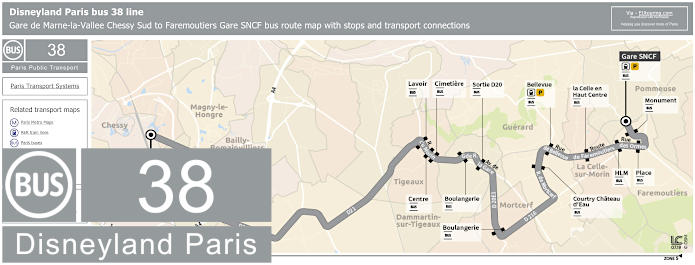
The Bus line 38 run by Transdev travels between Faremoutiers - Gare SNCF and Chessy - Gare Sud RER with several bus stops in between, and as you can see from the map and timetables, these show different transport connections along with the corresponding connection times for the RER A to or from Paris, as this bus route only operates during peak hours on a Monday to Friday.

Disneyland Paris bus 38 line stops:


Chessy - Gare Sud (Quai A)*, Chessy - Gare Sud (Quai J)**, Tigeaux - Lavoir, Centre, Cimetiere, Dammartin-sur-Tigeaux - Boulangerie, Sortie D20, Mortcerf - Boulangerie*, Guerard - Courtry Chateau d'Eau, Bellevue, La Celle-sur-Morin - La Celle en Haut Centre, Faremoutiers - HLM, Place, Monument, Faremoutiers Gare SNCF.

* In the direction of Disneyland Paris Chessy Gare Sud.
** In the direction of Faremoutiers Gare SNCF.

Disneyland Paris bus 38 main transport connections:


Train lines: A, P.

Disneyland Paris bus 38 route maps and timetables available:


Disneyland Paris Bus 38 map and timetables - PDF (0.337 MB)
Disneyland Paris Bus 38 map and timetables - Image (0.775 MB)

RATP Paris bus line 38 with stops, connections and street plan

Paris bus 38 map with stops and connections
Here you can see the map showing the Paris Bus route for the RATP line 38, which travels between the Porte d'Orleans and Porte de la Chapelle with an additional 38 different bus stops getting you to famous tourist attractions like Denfert-Rochereau - Daguerre, Val de Grace, Luxembourg, Cite - Palais de Justice, Chatelet, Les Halles-Centre Georges Pompidou, Centre Georges Pompidou, Chateau d'Eau, Gare de l'Est, Gare du Nord, Les Roses and many more.

Paris bus line 38 stops:


Porte d'Orleans, Alesia - General Leclerc, Alesia - Maine*, Mouton - Duvernet, Denfert-Rochereau - Daguerre**, Denfert-Rochereau*, Denfert-Rochereau - Arago, Hopital Saint-Vincent de Paul, Observatoire - Port-Royal, Val de Grace, Auguste Comte, Luxembourg, Les Ecoles, Saint-Michel - Saint-Germain, Cite - Palais de Justice, Chatelet, Coutellerie*, Les Halles - Centre Georges Pompidou**, Centre Georges Pompidou*, Turbigo - Etienne Marcel**, Grenier St-Lazare - Quartier de l’Horloge*, Reaumur - Arts et Metiers*, Reaumur - Sebastopol**, Strasbourg - Saint-Denis**, Porte Saint-Martin*, Chateau d’Eau**, Mairie du 10e*, Magenta - Saint-Martin*, Gare de l’Est, Valenciennes, Gare du Nord, Cail-Demarquay, Place de la Chapelle, Departement-Marx Dormoy, Ordener - Marx Dormoy, Les Roses, Boucry, Porte de la Chapelle.

*Stops served in direction of Porte d'Orleans.
** Stops served in direction of Porte de la Chapelle.

Paris bus line 38 main transport connections:


Merto Lines: 1, 2, 3, 4, 5, 6, 7, 8, 9, 11, 12, 14.
Train Lines: A, B, C, D, E, H, K, P.
Tram Lines: T3a, T3b.

Paris bus 38 route maps available:


RATP Bus Line 38 map - PDF (standard quality - 0.590 MB)
RATP Bus Line 38 map - PDF (high quality - 1.672 MB)
RATP Bus Line 38 map - Image (standard quality - 0.536 MB)
RATP Bus Line 38 map - Image (high quality - 0.949 MB)

Paris bus 38 timetables:


RATP Bus 38 timetables - PDF (0.503 MB)
RATP Bus 38 timetables - Image (1.332 MB)
Paris bus 39 stop Place du Carrousel

RATP Paris bus line 39 with stops, connections and street plan

Paris bus 39 map with stops and connections
Yet this map shows the Paris Bus route for the RATP line 39 that travels between Freres Voisin and Gare du Nord, and this service has over 50 different bus stops and some of these include places like Severine, Desnouettes, Lycee Louis Armand, Convention - Lecourbe, Gare Montparnasse, Musee du Louvre, Bourse, Grands Boulevards, Strasbourg-Saint-Denis, the Gare de l'Est and Gare du Nord Dunkerque train stations and numerous other bus stops on this route.

Paris bus line 39 stops:


Freres Voisin, Maison de Retraite**, Colonel Pierre Avia*, Severine**, Louis Armand*, Suzanne Lenglen*, Porte d’Issy**, Balard*, Balard - Lecourbe*, Desnouettes**, Desnouettes - Vasco de Gama**, Lycee Louis Armand*, Hameau**, Duranton**, Hopital de Vaugirard**, Convention - Lecourbe*, Convention - Vaugirard**, Abbe Groult, Mairie du 15e*, Vaugirard - Favorites**, Cambronne - Lecourbe*, Cambronne - Vaugirard**, Volontaires - Lecourbe*, Volontaires - Vaugirard**, Sevres - Lecourbe*, Pasteur - Lycee Buffon, Armorique - Musee Postal, Gare Montparnasse, Montparnasse - Rue de l’Arrivee*, Montparnasse**, Rennes - Littre, Rennes - Saint-Placide, Rennes - d’Assas, Michel Debre, Saint-Germain des Pres, Jacob, Pont du Carrousel - Quai Voltaire, Musee du Louvre, Palais Royal - Comedie Francaise, Sainte-Anne - Petits Champs**, Bibliotheque Nationale*, Richelieu - 4 Septembre, Richelieu - Drouot*, Bourse**, Grands Boulevards*, Reaumur - Montmartre**, Poissonniere - Bonne Nouvelle*, Sentier**, Petites Ecuries*, Reaumur - Sebastopol**, Paradis*, Strasbourg - Saint-Denis**, La Fayette - Poissonniere*, Chateau d'Eau**, Magenta - Maubeuge*, Gare de l'Est**, Valenciennes**, Gare du Nord - Dunkerque*, Gare du Nord.

* Served in the direction of Freres Voisin
** Served in the direction of Gare du Nord

Paris bus line 39 main transport connections:


Metro lines: 1, 2, 3, 4, 5, 6, 7, 8, 9, 10, 12, 13.
Train lines: B, D, E, H, K, N, P.
Tram lines: T2, T3a.

Paris bus 39 route maps available:


RATP Bus Line 39 map - PDF (standard quality - 0.625 MB)
RATP Bus Line 39 map - PDF (high quality - 1.766 MB)
RATP Bus Line 39 map - Image (standard quality - 0.579 MB)
RATP Bus Line 39 map - Image (high quality - 1.040 MB)

Paris bus 39 timetables:


RATP Bus 39 timetables - PDF (0.469 MB)
RATP Bus 39 timetables - Image (1.245 MB)

Paris bus 39 map for CDG Airport to Gare du Vert Galant with stops, connections and street plan

Paris Bus 39 map from CDG airport to Gare du Vert Galant
Although here you can see another bus line 39 that is run by the transport company Keolis, which is a bus route going from Vert Galant Gare within the Villepinte commune of Ile de France through to the Charles de Gaulle Airport Train station, with stops on the way that include the Parc des Expositions Gare by the Convention Centre. Although as you can tell from the plan and timetables, there are certain bus stops only served in a particular direction, yet the Fileo buses also cover this route during the night time and at other times for a continuous bus service to and from CDG 1.

Paris bus line 39 CDG1 stops:


Gare de Roissypole - Aeroport CDG 1, Terminal 2 - Route de Service**, Rue des Vignes, Rue du Chapitre, Les Deux Cedres, Cargo Centre, Marguilliers, Aeroville, Bois de la Pie 351*, Parc des Nations**, 372 Rue de la Belle Etoile*, 190 Rue des Chardonnerets, 89 Rue des Chardonnerets, 33 Rue des Chardonnerets, Rue de l'Etang, Gare du Parc des Expositions, Rue du Sausset, Claude Nicolas Ledoux, Labe, Laurencin, Schuman, Monnet, Sisley, Cimetiere de Villepinte, Route de Tremblay, Les Mousseaux, Parc de la Noue, Fougeres, Georges Sachet, Jussieu, Fontaine Mallet, La Roseraie, Place Rene Droulot, Poste, Parmentier, Gare du Vert Galant.

* Bus stop only served in direction of Gare de Vert Galant.
** Bus stop only served in direction of Gare de Roissypole Aeroport CDG 1.

Paris bus line 39 CDG1 main transport connections:


Train Lines: B, CDG Val, TGV.
Bus lines: 1, 15, 19, 20, 22, 23, 24, 27, 32, 32za, 40, 43, 45, 67, 93, 95-01, 95-02, 95-18, 100, 100, 349, 350, 351, 619, 640, 642, 643, 701, 702, R4, Le Bus Direct, N41, N140, N143, RoissyBus, T'bus 1, T'bus 2, T'bus 3.

Paris bus 39 CDG1 route maps available:


Paris Bus 39 CDG1 map - PDF (standard quality - 0.631 MB)
Paris Bus 39 CDG1 map - PDF (high quality - 1.270 MB)
Paris Bus 39 CDG1 map - Image (standard quality - 0.638 MB)
Paris Bus 39 CDG1 map - Image (high quality - 1.105 MB)

Paris bus 39 timetables direction CDG Airport to Villepinte:


Paris Bus 39 timetables CDG1 to Villepinte - PDF (0.929 MB)
Paris Bus 39 timetables CDG1 to Villepinte - Image (2.209MB)

Paris bus 39 timetables direction Villepinte to CDG Airport:


Paris Bus 39 timetables Villepinte to CDG1 - PDF (0.931 MB)
Paris Bus 39 timetables Villepinte to CDG1- Image (2.229 MB)
Paris bus 38 stop Avenue du Colonel Henri Rol-Tanguy

Paris bus 39-12 map for Gare de Versailles-Chantiers to Merantais with stops, connections and street plan

Paris Bus 39-12 map for Chateau de Versailles
Whereas here you can see that bus route 39-12 operated by the transport company Savac that travels from the impressive train station of Gare de Versailles Chantiers through to Merantais, with only a few stops in between including Golf National in the Guyancourt area of the Paris region and the Gare de Versailles Rive Gauche, which is the nearest station to the famous royal castle.

Paris bus line 39-12 stops:


Gare de Versailles Chantiers - Gare Routiere, Gare de Versailles Chateau Rive Gauche - Sceaux, Freres Perret, Technocentre 60 Arpents* **, Technocentre Le Gradient, Technocentre l'Etang* **, Technocentre Trou Berger**, Villaroy Sud**, Golf National**, Merantais**.

* Stop served in a specific direction one way, but only at specific times in the opposite direction.
** Stop only served at specific times.

Paris bus line 39-12 main transport connections:


Train Lines: C, N, U.
Bus Lines: 1, 2, 4, 6, 11, 13, 22, 24, 260, 261, 263, 264, 439, 440, Express 1, N145.

Paris bus 39-12 route maps available:


Paris Bus 39-12 map - PDF (standard quality - 0.730 MB)
Paris Bus 39-12 map - PDF (high quality - 2.615 MB)
Paris Bus 39-12 map - Image (standard quality - 0.745 MB)
Paris Bus 39-12 map - Image (high quality - 1.292 MB)

Paris bus 39-12 timetables:


Paris Bus 39-12 timetables - PDF (3.166 MB)
Paris Bus 39-12 timetables - Image (2.244 MB)

Paris bus 39-34 map from Place Jules Guesde to Technocentre Trou Berger with stops and street plan

Paris bus line 39-34 map with stops
Here you can see the bus line 39-34 run by the transport company Savac, which travels between the communes, or areas of the Paris region, of Boulogne-Billancourt and Guyancourt, with the terminus points being Place Jules Guesde and Technocentre Trou Berger. Yet as you can see from the maps and timetables, the bus stops of Provence and Technocentre l'Etang are only served in a particular direction and the line only operates at certain times on a Monday to Friday, but not at weekends or National French holidays, in addition to one specific time being a private run and not for the general public.

Paris bus line 39-34 stops:


Boulogne-Billancourt - Place Jules Guesde, Pont de Sevres, Meudon - Le Mail, Velizy-Villacoublay - Louvois, Mairie de Velizy, L'Onde - Maison des Arts, Provence*, Versailles - Cite des Cadres, Guyancourt - La Miniere, Freres Perret, Technocentre 60 Arpents, Technocentre Le Gradient, Technocentre l'Etang*, Technocentre Trou Berger.

* Only served in a specific direction.

Paris bus line 39-34 main transport connections:


Tram line: T6.
Bus lines: 23, 24, 34, 39-12, 42, 45, 89, 307, 439, 440, 441.

Paris bus 39-34 route maps available:


Paris Bus 39-34 map - PDF (3.051 MB)
Paris Bus 39-34 map - Image (1.486 MB)

Paris bus 39-34 timetables:


Paris Bus 39-34 timetables - PDF (0.830 MB)
Paris Bus 39-34 timetables - Image (2.004 MB)