How to get to Bataclan in Paris using public transport
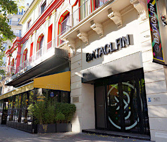
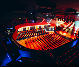
Bataclan is an historical entertainment venue that first opened in the 1800s and still maintaining its Chinese Pagoda appearance, it plays host to numerous concerts from a variety of music genres including rock, pop and world music, etc, with many international stars along with up and coming artists gracing the stage each year. So below you can discover plans, information, street maps and public transport timetables for how to get to Bataclan, which can all be downloaded in PDF or image format to your PC or mobile device.
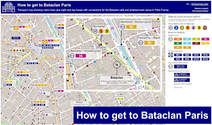
Bataclan transport map of Metro lines and bus lines with stops, connections and street plan
Here you can see a street map showing the location of Bataclan and how to get to this entertainment venue with Paris public transport that includes the Metro stations and numerous bus stops for the various day and night bus, all of which are between around 140 metres and 1300 metres walking distance of the Bataclan.
How to get to Bataclan public transport maps available:
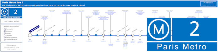
Paris Metro Line 2 map with stations, connections and points of interest
This shows the Paris Metro line 2 maps that travels between Porte Dauphine and Nation, and as you can see, the nearest stops to Bataclan are the Menilmontant station and the Couronnes station, which are the furthest from the entertainment venue at over 1100 metres walking distance.
Metro Line 2 stops:
Porte Dauphine, Victor Hugo, Charles de Gaulle - Etoile, Ternes, Courcelles, Monceau, Villiers, Rome, Place de Clichy, Blanche, Pigalle, Anvers, Barbes - Rochechouart, La Chapelle, Stalingrad, Jaures, Colonel Fabien, Belleville, Couronnes, Menilmontant, Pere Lachaise, Philippe Auguste, Alexandre Dumas, Avron, Nation.
Metro line 2 main transport connections:
Metro Lines: 1, 3, 4, 5, 6, 7, 7bis, 9, 11, 12, 13. Train Lines: A, B, C, D, E, H, K, Funiculaire du Montmartre.
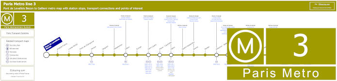
Paris Metro Line 3 map with stations, connections and points of interest
Travelling between Pont de Levallois - Becon and Gallieni for Parc de Bagnolet, you will find that the Paris Metro line 3 stops at the large Republique Metro station for getting to Bataclan, yet this is also an option for getting to the Grand Rex via the Sentier stop along with other Paris entertainment venues in addition to the many transport connections.
Metro Line 3 stops:
Pont de Levallois Becon, Anatole France, Louise Michel, Porte de Champerret, Pereire, Wagram, Malasherbes, Villiers, Europe, Saint-Lazare, Havre - Caumartin, Opera, Quatre-Septembre, Bourse, Sentier, Reaumur - Sebastopol, Arts et Metiers, Temple, Republique, Parmentier, Rue Saint-Maur, Pere Lachaise, Gambetta, Porte de Bagnolet, Gallieni.
Metro line 3 main transport connections:
Metro Lines: 2, 3b, 4, 5, 7, 8, 9, 11, 12, 13, 14. Train Lines, A, C, E , J, L. Tram Line: T3b. Bus Line: RoissyBus.
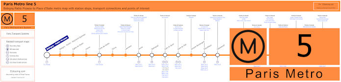
Paris Metro Line 5 map with stations, connections and points of interest
Whereas the Metro line 5 has a stop at Oberkampf for the Bataclan, which is the closest Metro station at approximately a 3 minute walk, however, travelling between Bobigny - Pablo Picasso and Place d'Italie this is also an option for how to get to Zenith and other entertainment venues within Parc de la Villette via the Porte de Pantin stop.
Metro Line 5 stops:
Bobigny - Pablo Picasso, Bobigny - Pantin - Raymond Queneau, Eglise de Pantin, Hoche, Porte de Pantin, Ourcq, Laumiere, Jaures, Stalingrad, Gare du Nord, Gare de l'Est, Jacques Bonsergent, Republique, Oberkampf, Richard-Lenoir, Breguet - Sabin, Bastille, Quai de la Rapee, Gare d'Austerlitz, Saint-Marcel, Campo-Formio, Place d'Italie.
Metro line 5 main transport connections:
Metro Lines: 1, 2, 3, 4, 6, 7, 7b, 8, 9, 10, 11. Train Lines: B, C, D, E, H, K, P. Tram Lines: T1, T3b.
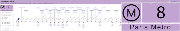
Paris Metro Line 8 map with stations, connections and points of interest
Getting to the Bataclan via Metro line 8 means you could utilise the Filles du Calvaire stop or the Republique stop, both within easy walking distance, and this particular line runs from Balard through to Creteil - Pointe du Lac, which is also how to get to Les Invalides and other Paris tourist attractions including the Ecole Militaire where Napoleon Bonaparte once studied.
Metro line 8 stops:
Balard, Lourmel, Boucicaut, Felix Faure, Commerce, La Motte-Picquet - Grenelle, Ecole Militaire, La Tour-Maubourg, Invalides, Concorde, Madeleine, Opera, Richelieu-Drouot, Grands Boulevards, Bonne Nouvelle, Strasbourg - Saint-Denis, Republique, Filles du Calvaire, Saint-Sebastien - Froissart, Chemin Vert, Bastille, Ledru-Rollin, Faidherbe - Chaligny, Reuilly - Diderot, Montgallet, Daumesnil, Michel Bizot, Porte Doree, Porte de Charenton, Liberte, Charenton - Ecoles, Ecole Veterinaire de Maisons-Alfort, Maisons-Alfort - Stade, Maisons-Alfort - Les Juilliottes, Creteil - L'Echat, Creteil - Universite, Creteil - Prefecture, Creteil - Pointe du Lac.
Metro line 8 main transport connections:
Metro Lines: 1, 3, 4, 5, 6, 7, 9, 10, 11, 12, 13, 14. Train Lines: A, C. Tram Lines: T2, T3a. Bus Lines: RoissyBus, TVM (14).
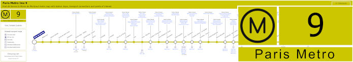
Paris Metro Line 9 map with stations, connections and points of interest
However, the Paris Metro line 9 goes between Pont de Sevres and Mairie de Montreuil and this is one of the options for getting to the Parc des Princes stadium via the Porte de Saint-Cloud stop, yet for Bataclan you could utilise the Republique stop, although only around a 3 minute walk and you would be at the Oberkampf Metro station, which is closest to this particular entertainment venue.
Metro line 9 stops:
Pont de Sevres, Billancourt, Marcel Sembat, Porte de Saint-Cloud, Exelmans, Michel-Ange - Molitor, Jasmin, Ranelagh, La Muette, Rue de la Pompe, Trocadero, Iena, Alma - Marceau, Franklin D Roosevelt, Saint-Philippe-du-Roule, Miromesnil, Saint-Augustin, Havre - Caumartin, Chaussee d'Antin - La Fayette, Richelieu - Drouot, Grands Boulevards, Bonne Nouvelle, Strasbourg - Saint-Denis, Republique, Oberkampf, Saint-Ambrose, Voltaire, Charonne, Rue des Boulets, Nation, Buzenval, Maraichers, Porte de Montreuil, Robespierre, Croix de Chavaux, Mairie de Montreuil.
Metro line 9 main transport connections:
Metro Lines: 1, 2, 3, 4, 5, 6, 7, 8, 10, 11, 13, 14. Train Lines: A, C, E. Tram Lines: T2, T3b. Bus Line: RoissyBus.
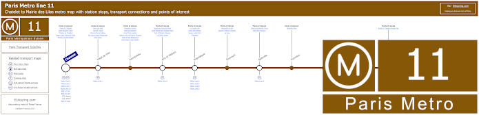
Paris Metro Line 11 map with stations, connections and points of interest
The Paris Metro line 11 travels from Mairie des Lilas and as you can see from the Metro maps, the opposite terminus is Chatelet with its numerous transport connections and this stop would be how to get to Le Duc des Lombards Jazz Club plus many other entertainment places and Paris tourist attractions, but for Bataclan you would again need the Republique Metro station.
Metro line 11 stops:
Chatelet, Hotel de Ville, Rambuteau, Arts et Metiers, Republique, Goncourt, Belleville, Pyrenees, Jourdain, Place des Fetes, Telegraphe, Porte des Lilas, Mairie des Lilas.
Metro line 11 main transport connections:
Metro Lines: 1, 2, 3, 3bis, 4, 5, 7, 7bis, 8, 9, 14. Train Linea: A, B, D. Tram Line: T3b.
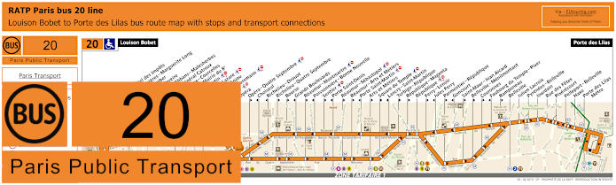
RATP Paris bus line 20 with stops, connections and street plan
So here we have the Paris bus line 20 run by the transport company RATP, which travels between Louis Bobet and Porte des Lilas and is way of getting to Palais Garnier Opera House via the Opera stop, but also a way of getting to the Bataclan via the Republique stop, but please bear in mind there are many bus stops on route that are direction dependant as you can see from the bus maps and timetables.
Paris bus line 20 stops:
Louison Bobet, Alsace**, Curnonsky*, Reims - Hotel des Impots*, Porte d’Asnieres - Marguerite Long, Juliette Lamber, Wagram - Pereire, Jouffroy d’Abbans - Malesherbes, Place du General Catroux, Malesherbes - Courcelles, Lisbonne - Mairie du 8e, Saint-Augustin, Gare Saint-Lazare*, Pasquier - Anjou*, Havre - Haussmann, Auber, Opera, Opera - Quatre Septembre**, Choiseul*, Richelie - Drouot*, Richelieu - Quatre Septembre**, Bourse**, Grands Boulevards*, Reaumur - Montmartre**, Poissonniere - Bonne Nouvelle*, Sentier**, Porte Saint-Denis*, Reaumur - Sebastopol**, Reaumur - Arts et Metiers**, Porte Saint-Martin*, Arts et Metiers**, Square du Temple**, Lancry - Saint-Martin*, Turbigo - Republique**, Republique - Magenta**, Republique, Ferry - Lenoir**, Jules Ferry*, Parmentier - Republique**, Goncourt*, Saint-Maur - Jean Aicard**, Belleville - Menilmontant**, Couronnes**, Faubourg du Temple - Piver*, Ramponeau**, Belleville, Julien Lacroix, Pyrenees - Belleville, Jourdain, Rue des Fetes, Pixerecourt, Pelleport - Belleville, Haxo, Porte des Lilas Metro, Porte des Lilas.
* Served in direction of Louison Bobet. ** Served in direction of Porte des Lilas.
Paris bus line 20 main transport connections:
Metro Lines: 2, 3, 3bis, 4, 5, 7, 8, 9, 11, 12, 13, 14. Train Lines: A, E, J, L. Tram Line: T3b.
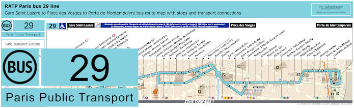
RATP Paris bus 29 map with stops, connections and street plan
Whereas the bus line 29 travels from Porte de Montempoivre through to Gare Saint Lazare train station, however, we would like to point out that during a day on a Sunday this Paris bus route only goes to Place des Vosges, as you can see from the maps and timetables, yet you may be pleased to know that it is the Places des Vosges bus stop you would need in order to walk to the Bataclan.
Paris bus line 29 stops:
Gare Saint-Lazare, Havre - Haussmann, Auber, Opera, Opera - Quatre Septembre, Petits Champs - Danielle Casanova**, Richelieu - Quatre Septembre*, Bibliotheque Nationale**, Bourse*, Mairie du 2e*, Victoires, Louvre - Etienne Marcel**, Etienne Marcel - Montmartre, Turbigo - Etienne Marcel, Sebastopol - Etienne Marcel, Grenier St-Lazare - Quartier de l’Horloge, Centre Georges Pompidou*, Archives - Rambuteau*, Archives - Haudriettes**, Rue Vieille du Temple, Turenne - Saint-Gilles**, Payenne*, Place des Vosges*, Tournelles-Saint-Gilles**, Bastille - Beaumarchais, Bastille, Lyon - Ledru-Rollin*, Daumesnil - Ledru-Rollin**, Gare de Lyon - Diderot*, Daumesnil - Diderot (Gare de Lyon), Rambouillet, Charles Bossut, Mairie du 12e, Dubrunfaut, Daumesnil - Felix Eboue, Docteur Goujon - Reuilly, Picpus - Reuilly, Hopital Rothschild, Fabre d’Eglantine, Picpus, Docteur Netter, Porte de Saint-Mande, J. Lemaitre - M. Ravel*, Porte de Montempoivre.
* Served in direction of Porte de Montempoivre. ** Served in direction of Gare Saint-Lazare.
Paris bus line 29 main transport connections:
Metro Lines: 1, 3, 4, 5, 6, 7, 8, 9, 11, 12, 13, 14. Train Lines: A, D, E, J, L, R. Tram Line: T3a.
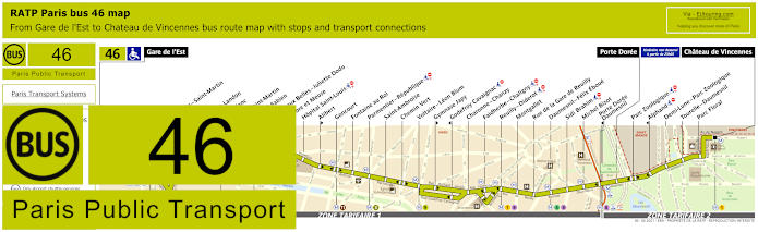
RATP Paris bus line 46 with stops, connections and street plan
The Paris bus line 46 is one option for how to get to Chateau de Vincennes, which is the medieval castle on the outskirts of Paris, and travelling through to Gare de l’Est train station, which is where you can get connections to RER and SNCF Transilien train lines, but you will find that the Saint-Ambroise or Parmentier - Republique bus stops are the closest to Bataclan depending upon which way you walk.
Paris bus line 46 stops:
Gare de l'Est, Magenta - Saint-Martin**, Verdun, Chateau Landon, Louis Blanc**, Canal Saint-Martin, Colonel Fabien**, Grange aux Belles - Juliette Dodu*, Sambre et Meuse**, Hopital Saint-Louis, Alibert*, Goncourt, Fontaine au Roi, Parmentier - Republique, Saint-Ambroise, Chemin Vert, Voltaire - Leon Blum, Gymnase Japy*, Godefroy Cavaignac**, Charonne - Chanzy, Faidherbe - Chaligny, Reuilly - Diderot, Montgallet, Rue de la Gare de Reuilly, Daumesnil - Felix Eboue, Sidi Brahim, Michel Bizot, Porte Doree - Daumesnil**, Porte Doree, Parc Zoologique, Alphand**, Demi-Lune - Parc Zoologique, Tourelle - Daumesnil, Parc Floral, Chateau de Vincennes.
* Stop served in direction of Chateau de Vincennes. ** Stop served in direction of Gare de l'Est.
Paris bus line 46 main transport connections:
Metro lines: 1, 2, 3, 4, 5, 6, 7, 7bis, 8, 9, 11 Train lines: E, P Tram lines: T3a
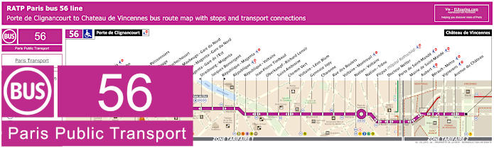
RATP Paris bus line 56 with stops, connections and street plan
Yet the closest of all Paris buses that go near the Bataclan entertainment venue, is the RATP bus line 56, which is the Oberkampf - Richard Lenoir bus stop on the Boulevard Voltaire at around 140 metres walk, and as you can see from the street maps, this bus route goes between Porte de Clignancourt and Chateau de Vincennes.
Paris bus line 56 stops:
Porte de Clignancourt, Mont-Cenis*, Albert Kahn, Simplon, Marcadet - Poissonniers, Chateau Rouge, Barbes - Rochechouart, Magenta - Maubeuge - Gare du Nord, La Fayette - Magenta - Gare du Nord, Magenta - Gare de l’Est, Strasbourg - Magenta*, Jacques Bonsergent, Republique - Magenta*, Republique, Republique - Voltaire, Jean-Pierre Timbaud, Oberkampf - Richard Lenoir, Saint-Ambroise, Chemin Vert, Voltaire - Leon Blum, Gymnase Japy, Charonne, Rue des Boulets, Voltaire - Montreuil, Nation - Voltaire, Nation - Trone, Picpus (Hopital Rothschild), Docteur Netter, Porte de Saint-Mande, Mairie de Saint-Mande, Aubert, Berault - Metro, Vignerons, Avenue du Chateau, Chateau de Vincennes.
* Bus stop is direction dependant.
Paris bus line 56 main transport connections:
Metro Lines: 1, 2, 3, 4, 5, 6, 8, 9, 11, 12. Train Lines: A, B, D, E, H, K. Tram Line: T3b.
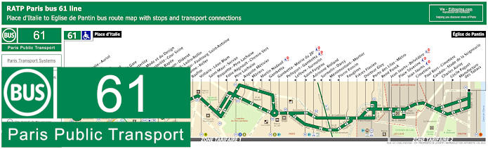
RATP Paris bus 61 map with stops, connections and street plan
Travelling between Place d'Italie and Eglise de Pantin, which is an option for getting to Gare de Lyon train station with its many transport connections, you will find that the RATP bus line 61 has a stop called Voltaire - Leon Blum that will get you within walking distance of Bataclan, albeit approximately 1000 metres away.
Paris bus line 61 stops:
Place d'Italie, Place d'Italie - Auriol, Les Alpes, Nationale, Chevaleret, Quai de la Gare, Quai d'Austerlitz, Cite de la Mode et du Design, Gare d'Austerlitz - Cour Seine, Quai de la Rapee, Gare de Lyon - Diderot, Daumesnil - Ledru-Rollin, Ledru-Rollin - Faubourg Saint-Antoine, Charonne - Keller, Basfroi, Voltaire - Leon Blum, Saint-Maur - Servan, Roquette - Pere Lachaise, Folie-Regnault - Chemin Vert, Pere Lachaise, Auguste Metivier, Muriers, Martin Nadaud, Gambetta, Gambetta - Mairie du 20e, Pelleport - Gambetta, Lefevre - Surmelin, Saint-Fargeau, Adrienne Bolland, Surmelin - Darcy, Menilmontant - Mortier, Pierre Foncin, Fougeres, Freres Flavien, Docteur Gley, Porte des Lilas - Metro, Rene Fonck, Jean Jaures - Belvedere, Place Severine, Jean Jaures, Cimetiere, Paul Bert - Cimetiere, Candale - Stade de la Seigneurie, Charles Auray, Cecile Faguet, Manufacture des Tabacs, Eglise de Pantin.
Paris bus line 61 main transport connections:
Metro Lines: 1, 2, 3, 3bis, 5, 6, 7, 8, 9, 10, 11, 14. Train Lines: A, C, D, R. Tram Line: T3b.
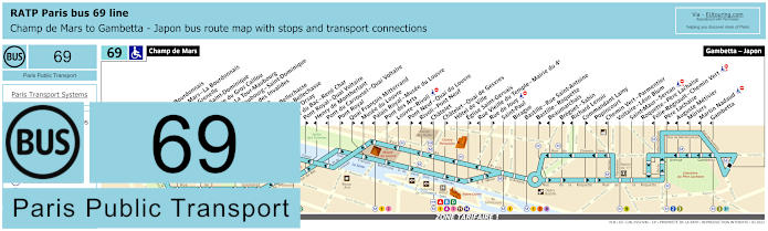
RATP Paris bus line 69 with stops, connections and street plan
However, as you can see from these Paris bus maps and timetables, the bus line 69 goes from Champ de Mars, which is how to get to the Eiffel Tower, and travels to Gambetta - Japon with numerous stops on route, although please be aware that some bus stops like the Musee du Louvre are direction dependant, yet for the Bataclan, again you would need the Voltaire - Leon Blum stop.
Paris bus line 69 stops:
Champ de Mars, Rapp - La Bourdonnais, Champ de Mars - La Bourdonnais*, Bosquet - Grenelle*, Bosquet - Saint-Dominique**, Saint-Pierre du Gros Caillou, Invalides - La Tour-Maubourg*, La Tour-Maubourg - Saint-Dominique**, Esplanade des Invalides, Bourgogne, Grenelle - Bellechasse*, Solferino - Bellechasse, Musee d’Orsay*, Rue du Bac - Rene Char, Pont Royal - Quai Voltaire**, Henry de Montherlant*, Pont du Carrousel - Quai Voltaire*, Pont Royal**, Quai Francois Mitterrand**, Musee du Louvre*, Palais Royal - Musee du Louvre*, Pont des Arts**, Louvre - Rivoli* ***, Pont Neuf - Quai du Louvre**, Rivoli - Pont Neuf*, Chatelet*, Chatelet - Quai de Gesvres**, Hotel de Ville, Eglise Saint-Gervais**, Rue Vieille du Temple - Mairie du 4e*, Rue de Jouy** ***, Saint-Paul, Birague, Bastille - Rue Saint-Antoine, Bastille - Roquette**, Beaumarchais*, Breguet - Sabin**, Richard Lenoir*, Commandant Lamy**, Popincourt, Chemin Vert - Parmentier*, Voltaire - Leon Blum, Saint-Maur - Servan***, Roquette - Pere Lachaise, Folie-Regnault - Chemin Vert* ***, Pere Lachaise**, Auguste Metivier*, Muriers, Martin Nadaud***, Gambetta, Gambetta - Japon.
* Stop served in direction of Champ de Mars. ** Stop served in direction of Gambetta - Japon. *** Not accessible to those with reduced mobility.
Paris bus line 69 main transport connections:
Metro Lines: 1, 2, 3, 3bis, 4, 5, 7, 8, 9, 11, 12, 13, 14. Train Lines: A, B, C, D.
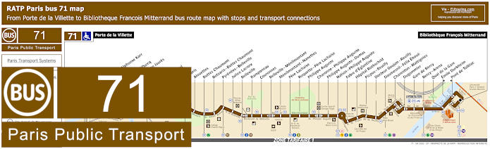
RATP Paris bus 71 map with stops, connections and street plan
Although the Paris bus line 71 travels from Porte de la Villette through to Bibliotheque Francois Mitterrand, and as you can see from the street maps and timetables, this is one of the options for getting to the Philharmonie de Paris via the Ourcq - Jean Jaures stop along with the Bataclan via the Belleville - Menilmontant bus stop, which is approximately a 1200 metre walk from this entertainment venue.
Paris bus line 71 stops:
Porte de la Villette, Cambrai**, Flandre - Alphonse Karr, Flandre, Canal de l'Ourcq, Ourcq - Jean Jaures, Ourcq, Goubet, D'Hautpoul, Manin, Botzaris, Alouettes, Buttes Chaumont, Pyrenees - Belleville, Julien Lacroix, Belleville, Ramponeau, Couronnes, Belleville - Menilmontant, Menilmontant - Nanettes, Pere Lachaise, Roquette - Pere Lachaise, Philippe Auguste, Charonne - Philippe Auguste, Philippe Auguste - Dumas, Nation - Philippe Auguste, Fabre d'Eglantine, Hopital Rothschild, Picpus - Reuilly, Docteur Goujon - Reuilly, Daumesnil - Felix Eboue, Charenton - Wattignies, Dugommier, Gare de Bercy, Bercy - Arena, Quai de la Gare, Emile Durkheim**, Pont de Tolbiac*, Bibliotheque Francois Mitterrand.
* Stop served in direction of Porte de la Villette. ** Stop served in direction of Bibliotheque Francois Mitterrand.
Paris bus line 71 main transport connections:
Metro Lines: 1, 2, 3, 5, 6, 7, 7bis, 8, 11, 14. Train Lines: A, C. Tram Lines: T3a, T3b.
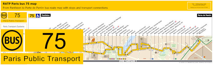
RATP Paris bus line 75 with stops, connections and street plan
You will find that the RATP bus line 75 is also great for getting to Paris tourist attractions like the Pompidou Centre and travelling from the famous Pantheon, this bus route goes to Porte de Pantin, which is how to get to the Grande Halle event venue, but for Bataclan you would need the Republique stop going in one direction or the Republique - Magenta stop going the opposite way.
Paris bus line 75 stops:
Pantheon, Lycee Henri IV**, Cardinal Lemoine - Monge**, Saint-Jacques - Saint Germain*, Institut du Monde Arabe*, Pont de l’Archeveche**, Petit Pont*, Quai aux Fleurs - Pont St-Louis**, Cite - Parvis Notre-Dame*, Pont d’Arcole**, Hotel de Ville**, Coutellerie*, La Verrerie**, Centre Georges Pompidou*, Archives - Rambuteau**, Grenier Saint-Lazare - Quartier de l’Horloge*, Archives - Haudriettes*, Square du Temple**, Arts et Metiers*, Turbigo - Republique, Republique - Magenta**, Republique*, Jules Ferry, Goncourt*, Alibert, Avenue Richerand**, Hopital Saint-Louis, Grange aux Belles - Juliette Dodu*, Sambre et Meuse**, Colonel Fabien, Mathurin Moreau - Simon Bolivar, Secretan - Buttes Chaumont, Jean Menans - Buttes Chaumont, Armand Carrel - Mairie du 19e, D’Hautpoul, Rhin et Danube, Lycee Diderot, Porte Brunet, General Cochet, Porte Chaumont, Marseillaises - Cheminets, Porte de Pantin - Marseillaise, Porte de Pantin.
* Stop served in direction of Pantheon. ** Stop served in direction of Porte de Pantin.
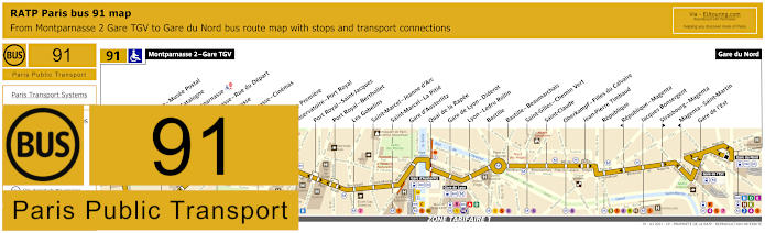
RATP Paris bus 91 map with stops, connections and route plan
This shows the maps and timetables for the Paris bus line 91 that travels between Gare du Nord and Montparnasse 2 - Gare TGV right by the Tour Montparnasse Tower, and this bus route is one option for how to get to Bastille and the Opera Bastille along with other entertainment venues in Paris including the Cirque d'Hiver and Bataclan via the Oberkampf - Filles du Calvaire bus stop.
Paris bus line 91 stops:
Montparnasse 2 - Gare TGV, Armorique - Musee Postal, Place de Catalogne, Gare Montparnasse, Montparnasse - Rue du Depart, Montparnasse, Montparnasse - Cinemas, Vavin, Campagne Premiere, Observatoire - Port Royal, Port Royal - Saint-Jacques, Port Royal - Berthollet, Les Gobelins, Saint-Marcel - Jeanne d'Arc, Saint-Marcel - La Pitie, Gare d'Austerlitz, Quai de la Rapee, Gare de Lyon - Diderot, Lyon - Ledru Rollin, Bastille, Bastille - Beaumarchais, Saint-Gilles - Chemin Vert, Saint-Claude, Oberkampf - Filles du Calvaire, Jean-Pierre Timbaud, Republique, Republique - Magenta, Jacques Bonsergent, Strasbourg - Magenta, Magenta - Saint-Martin, Gare de l'Est, Gare du Nord.
Paris bus line 91 main transport connections:
Metro Lines: 1, 2, 3, 4, 5, 6, 7, 8, 9, 10, 11, 12, 13, 14. Train Lines: A, B, C, D, E, H, K, N, P, R.
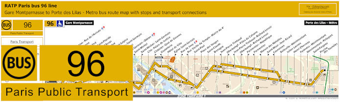
RATP Paris bus line 96 with stops, connections and street plan
Travelling from Porte des Lilas - Metro to Gare Montparnasse train station, as you will see from the RATP Paris bus line 96 maps and timetables, there are numerous stops that are direction dependant, so please look at these carefully, because for getting to Bataclan you would need the Oberkampf Richard Lenoir stop going one way or the J.P.Timbaud - Richard Lenoir stop in the opposite direction to Gare Montparnasse, which is the same scenario for the Parmentier - Republique stop and the Jean-Pierre Timbaud bus stop.
Paris bus line 96 stops:
Gare Montparnasse, Montparnasse - Rue de l’Arrivee*, Montparnasse**, Rennes - Littre, Rennes - Saint-Placide, Rennes - d’Assas, Michel Debre, Eglise Saint-Sulpice*, Bonaparte - Saint-Germain**, Seine - Buci**, Saint-Germain - Odeon, Saint-Michel*, Saint-Michel - Saint-Germain**, Cite - Palais de Justice, Chatelet - Quai de Gesvres**, Coutellerie*, Hotel de Ville, Eglise Saint-Gervais**, Rue de Jouy**, Rue Vieille du Temple - Mairie du 4e*, Saint-Paul, Place des Vosges, Saint-Claude, Bretagne, Jean-Pierre Timbaud*, Oberkampf - Filles du Calvaire**, Jean-Pierre Timbaud - Richard Lenoir*, Oberkampf - Richard Lenoir**, Parmentier - Republique**, Parmentier*, Maison des Metallos*, Saint-Maur - Jean Aicard**, Couronnes*, Belleville - Menilmontant, Julien Lacroix, Henri Chevreau, Pyrenees - Menilmontant, Menilmontant - Pelleport, Saint-Fargeau, Piscine des Tourelles, Port des Lilas - Metro.
* Stop served in direction of Gare Montparnasse. ** Stop served in direction of Porte des Lilas - Metro.
Paris bus line 96 main transport connections:
Metro Lines: 1, 2, 3, 3bis, 4, 5, 6, 7, 8, 9, 10, 11, 12, 13, 14. Train Lines: A, B, C, D, N. Tram Line: T3b.
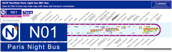
Paris Noctilien night bus N01 map with stops and transport connections
The Noctilien are night buses that run when other Paris public transport has stopped for the night, and referred to as Circulaire Interieure, the Noctilien N01 night bus goes in a complete circuit from Gare de l'Est train station, and as you can see from these bus maps and timetables you could catch this night bus via the Republique of the Oberkampf - Filles du Calvaire stops.
Paris night bus line N01 stops:
Gare de l'Est, Jacques Bonsergent, Republique, Oberkampf - Filles du Calvaire, Saint-Gilles - Chemin Vert, Bastille - Beaumarchais, Bastille, Lyon - Ledru-Rollin, Gare de Lyon - Diderot, Quai de la Rapee, Gare d'Austerlitz, Saint-Marcel - La Pitie, Saint-Marcel - Jeanne d'Arc, Les Gobelins, Port Royal - Berthollet, Observatoire - Port Royal, Campagne Premiere, Vavin, Montparnasse - Rue de l'Arrivee, Gare Montparnasse, Montparnasse, Rennes - Littre, Rennes - Saint-Placide, Rennes - d'Assas, Michel Debre, St-Germain-des-Pres, Pont du Carrousel - Quai Voltaire, Henry de Montherlant, Assemblee Nationale, Pont Alexandre III, Palais de la Decouverte, Rond-Point des Champs-Elysees - Matignon, Haussmann - Miromesnil, Saint-Augustin, Gare Saint-Lazare, Trinite, Liege, Place de Clichy, Blanche, Pigalle, Rochechouart - Martyrs, Anvers - Sacre-Coeur, Rochechouart - Clignancourt, Barbes - Rochechouart, Magenta - Mauberge - Gare du Nord, La Fayette - Magenta - Gare du Nord, Gare de l'Est.
Paris night bus line N01 main transport connections:
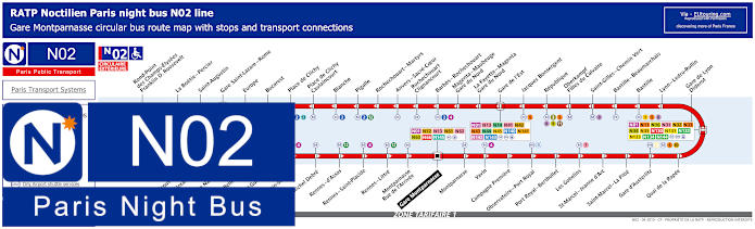
Paris Noctilien night bus N02 map with stops and transport connections
However, the Noctilien bus route for the night bus line N02, known as the Circulaire Exterieure, also travels in a complete circuit from Gare Montparnasse with numerous stops close to tourist attractions and popular entertainment venues including Republique and the Oberkampf - Filles du Calvaire night bus stops for getting to or from the Bataclan.
Paris night bus line N02 stops:
Gare Montparnasse, Montparnasse, Vavin, Campagne Premiere, Observatoire - Port Royal, Port Royal - Berthollet, Les Gobelins, Saint-Marcel - Jeanne d'Arc, Saint-Marcel - La Pitie, Gare d'Austerlitz, Quai de la Rapee, Gare de Lyon - Diderot, Lyon - Ledru-Rollin, Bastille, Bastille - Beaumarchais, Saint-Gilles - Chemin Vert, Oberkampf - Filles du Calvaire, Republique, Jacques Bonsergent, Gare de l'Est, La Fayette - Magenta - Gare du Nord, Magenta - Maubeuge - Gare du Nord, Barbes - Rochechouart, Rochechouart - Clignancourt, Anvers - Sacre-Coeur, Rochechouart - Martyrs, Pigalle, Blanche, Place de Clichy - Caulaincourt, Place de Clichy, Bucarest, Europe, Gare Saint-Lazare - Rome, Saint-Augustin, La Boetie - Percier, Rond-Point des Champs-Elysees - Franklin D. Roosevelt, Palais de la Decouverte, Pont Alexandre III, Assemblee Nationale, Solferino - Bellechasse, Saint-Guillaume, Saint-Germain-des-Pres, Michel Debre, Rennes - d'Assas, Rennes - Saint-Placide, Rennes - Little, Montparnasse - Rue de l'Arrivee, Gare Montparnasse.
Paris night bus line N02 main transport connections:
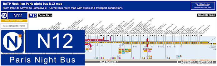
Paris Noctilien night bus N12 map with stops and transport connections
Whereas the Noctilien bus route for the RATP line N12, goes between Pont de Sevres and Romainville - Carnot and has stops where you can access various night bus connections such as Chatelet, yet there are numerous stops that are direction dependant, so please take a note of the maps and timetables carefully, yet for the Bataclan you would need the Republique stop that goes in both directions.
Paris night bus line N12 stops:
Pont de Sevres, Billancourt, Marcel Sembat, Rene Descartes, Henri Martin, Porte de Saint-Cloud, Porte de Saint-Cloud - Murat, Versailles - Chardon Lagache, Versailles - Exelmans, Victorien Sardou, Wilhem, Pont Mirabeau, Degas, Radio France - Pont de Grenelle, Pont de Grenelle - Maurice Bourdet, Pont de Grenelle - Pl. Fernand Forest, Charles Michels, Avenue Emile Zola, Cambronne, Sevres - Lecourbe, Pasteur - Lycee Buffon, Pasteur - Falguiere, Armorique - Musee Postal, Gare Montparnasse, Montparnasse - Rue de l’Arrivee, Montparnasse, Rennes - Littre, Rennes - Saint-Placide, Rennes - D'Assas, Michel Debre, Bonaparte - Saint-Germain, Saint-Germain-des-Pres, Jacob, Seine - Buci, Pont du Carrousel - Quai Voltaire, Saint-Germain - Odeon, Pont des Arts - Quai de Conti, Pont Neuf - Quai des Grands Augustins, Saint-Michel, Saint-Michel - Saint-Germain, Cite - Palais de Justice, Chatelet, Les Halles - Centre Georges Pompidou, Centre Georges Pompidou, Turbigo - Etienne Marcel, Grenier St-Lazare - Quartier de l’Horloge, Reaumur - Sebastopol, Reaumur - Arts et Metiers, Arts et Metiers, Square du Temple, Turbigo - Republique, Republique, Ferry - Lenoir, Parmentier - Republique, Saint-Maur - Jean Aicard, Jules Ferry, Goncourt, Belleville - Menilmontant, Vouronnes, Belleville, Pyrenees - Belleville, Jourdain, Pixerecourt, Pelleport - Belleville, Porte des Lilas, Les Bruyeres, Mairie des Lilas, Rue de Noisy-le-Sec, Paul de Kock, Joseph Depinay, Gagarine, Cimetiere de Bagnolet, Floreal, Les Noyers, Mairie de Romainville, Gabriel Husson, Romainville - Carnot.
Paris night bus line N12 main transport connections:
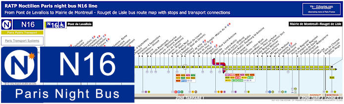
Paris Noctilien night bus N16 map with stops and transport connections
Yet here you have the timetables and maps for Noctilien N16 night bus line that travels between Pont de Levallois and Mairie de Montreuil - Rouget de Lisle and for the Bataclan you would need the Voltaire - Leon Blum night bus stop, yet please note that travelling into the Paris region this route goes to ticket tariff zones 2 and 3 and not zone 1 in the centre of Paris.
Paris night bus line N16 stops:
Pont de Levallois, Picasso*, Vaillant - Couturier*, Anatole France**, Mairie de Levallois*, Porte de Courcelles*, Porte de Champerret, Pereire - Le Chatelier*, Pereire - Villiers**, Europe, Gare Saint-Lazare - Rome**, Gare Saint-Lazare, Rome - Haussmann*, Havre - Haussmann**, Auber, Opera, Opera - 4 Septembre**, Choiseul*, Richelieu - 4 Septembre**, Richelieu - Drouot*, Bourse**, Grands Boulevards*, Reaumur - Montmartre, Louvre - Etienne Marcel, Bourse de Commerce, Louvre - Rivoli, Rivoli - Pont Neuf*, Pont Neuf - Quai du Louvre**, Chatelet - Quai de Gesvres**, Chatelet*, Hotel de Ville, Rue Vieille du Temple - Mairie du 4e*, Rue de Jouy**, Saint-Paul, Birague, Bastille - Rue Saint-Antoine, Bastille, Lyon - Ledru-Rollin, Gare de Lyon - Diderot, Daumesnil - Ledru-Rollin, Ledru-Rollin - Faubourg St-Antoine, Charonne - Keller, Basfroi, Voltaire - Leon Blum, Saint-Maur - Servan, Roquette - Pere Lachaise, Folie Regnault - Chemin Vert*, Auguste Metivier*, Pere Lachaise**, Muriers*, Martin Nadaud*, Gambetta*, Hopital Tenon*, Pelleport, Porte de Bagnolet, Echangeur de Bagnolet**, General de Gaulle, Republique - Robespierre, Fraternite, Sorins, Marche, Croix de Chavaux - Rouget de Lisle, Victor Hugo, Mairie de Montreuil - Rouget de Lisle.
* Served in direction of Pont de Levallois. ** Served in direction of Mairie de Montreuil - Rouget de Lisle.
Paris night bus line N16 main transport connections:
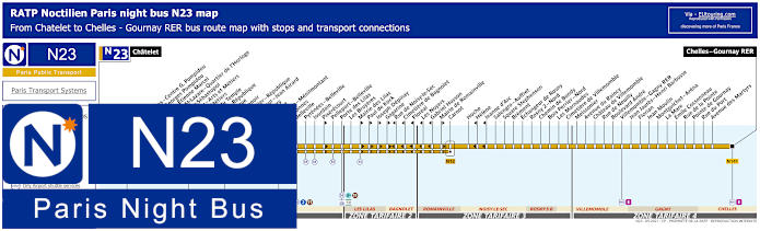
Paris Noctilien night bus N23 map with stops and transport connections
Going from Chatelet in Paris to Chelles - Gournay RER in ticket tariff zone 4 within the Paris region of Ile de France, the Noctilien N23 night bus line has a stop at Republique for when you are leaving Bataclan and this area late at night, but please bear in mind that many of the bus stops are only served in a particular direction like the Parmentier - Republique night bus stop.
Paris night bus line N23 stops:
Chatelet, Les Halles - Centre Georges Pompidou, Centre Georges Pompidou, Turbigo - Etienne Marcel, Grenier St-Lazare - Quartier d'Horloge, Reaumur-Sebastepol, Reaumur - Arts et Metiers, Arts et Metiers, Square du Temple, Turbigo - Republique, Republique, Ferry - Lenoir, Parmentier - Republique, Saint-Maur - Jean Aicard, Jules Ferry, Goncourt, Belleville - Menilmontant, Couronnes, Belleville, Pyrenees - Belleville, Jourdain, Pixerecourt, Pelleport - Belleville, Porte des Lilas, Les Bruyeres, Mairie des Lilas, Paul de Kock, Joseph Depinay, Gagarine, Rue de Noisy-le-Sec, Cimetiere de Bagnolet, Floreal, Les Noyers, Gabriel Husson, Mairie de Romainville, Carnot, Hoche, Helene, Jeanne d'Arc, Salengro - Auffret, Square Stephenson, Brement, Echangeur de Rosny, Rosny 2 - Nord, Chemin de Bondy, Bois - Perrier - Nord, Les Marnaudes, Cimetiere de Villemomble, Meissonier, Avenue du Raincy, Chateau de Villemomble, Rue de Neuilly, Boulevard Andre, Villemomble - Gagny RER, Jean Jaures - Henri Barbusse, Florian, Jean Moulin, Montguichet - Arena, La Mare, Emile Cossonneau, Rue de la Pointe, Pointe de Gournay, Rue du Port, Avenue des Martyrs, Chelles - Gourney RER.
Paris night bus line N23 main transport connections:
Metro Lines: 1, 2, 3, 3bis, 4, 5, 7, 8, 9, 11, 14. Train Lines: A, B, D, E. Tram Line: T3b. Bus Lines: N01, N02, N11, N12, N13, N14, N15, N16, N122, N141, N142.
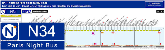
Paris Noctilien night bus N34 map with stops and transport connections
Whereas here you have the Noctilien line N34 that travels from Gare de Lyon - Diderot where you can access numerous public transport connections, through to Torcy RER, and for the Bataclan entertainment venue you would need the Basfroi or Voltaire - Leon Blum night bus stops, but please look at the maps and timetables carefully as some stops are direction dependant, not forgetting the different ticket zones.
Paris night bus line N34 stops:
Gare de Lyon - Diderot, Gare de Lyon - Maison de la RATP, Gare de Lyon - Diderot, Daumesnil - Ledru-Rollin, Ledru-Rollin - Faubourg Saint-Antoine, Charonne - Keller, Basfroi, Voltaire - Leon Blum, Saint-Maur - Servan, Roguette - Pere Lachaise, Folie-Regnault - Chemin Vert, Auguste Metivier, Pere Lachaise, Muriers, Martin Nadaud, Gambetta, Hopital Tenon, Pelleport, Porte de Bagnolet, Echangeur de Bagnolet, General de Gaulle, Republique - Robespierre, Fraternite, Sorins, Marche, Croix de Chavaux - Rouget de Lisle, Victor Hugo, Mairie de Montreuil - Rouget de Lisle, Mairie de Montreuil, Centre Administratif, Lycee Jean Jaures, Danton, Edouard Branly, Nouvelle France, Acacia, Fort de Rosny, Saint-Exupery, Babeuf, Charles Delavacquerie, Le Morillon, Jules Guesde, Cimetiere de Vincennes, La Fontaine, Jean Mace, Pablo Picasso, Val de Fontenay RER, Val de Fontenay RER - Louison Bobet, Croix d'Eau, Avron, Jules Ferry, Jouleau, Neuilly-Plaisance RER, Centre Bus, Helene Boucher, Villebois - Mareuil, Foch - De Gaulle, Place de la Resistance, Rene Navier, Route de Neuilly, Noisy-le-Grand - Mont d'Est RER, Republique, Espace Michel Simon, Mairie de Noisy-le-Grand, Carrefour de Malnoue, Pointe de Gournay, Les Prevoyants, Les Rosiers, Place Churchill, Rond-Point des Pyramides, C.S.T.B. - Matteotti, Les Iris, Pointe de Champs, Mairie de Champs, Maison de Retraite, Les Quatre Paves, Jules Ferry, La Remise aux Fraises, Cite Scolaire, La Mogotte, Bel Air, Les Tilleuls, Mairie de Torcy, La Mare aux Marchais, Rue des Epinettes, Jacques Prevert, Rives de Maubuee, Salvador Allende, Cites Unies, Torcy RER.
Paris night bus line N34 main transport connections:
Metro Lines: 1, 2, 3, 3bis, 8, 9, 14. Train Lines: A, D, E, R. Tram Line: T3b. Bus Lines: N01, N02, N11, N16, N31, N32, N33, N35, N71, N130, N131, N132, N133, N134, N141, N142, N144.
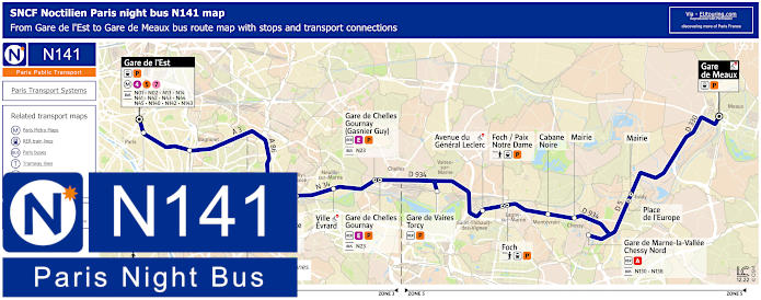
Paris Noctilien night bus N141 map with stops and transport connections
Although the Noctilien N141 night bus line is one of the options for getting to Disneyland Paris if you have been enjoying a night out in the capital city, because travelling from Gare de l'Est through to Meaux Gare Routiere, there is a stop called Gare de Marne la Vallee - Chessy, and from the Bataclan you would need the N141 Republique stop.
Paris night bus line N141 stops:
Gare de l'Est - Boulevard de Strasbourg, Republique - Place de la Republique, Porte de Bagnolet - Place de la Porte de Bagnolet, Gare de Neuilly Plaisance - Boulevard Gallieni, Ville Evrard - Avenue Jean Jaures - Hopital, Gare de Chelles Gournay - Gare routiere - Allee des Transporteurs - Avenue de la Resistance, Gare de Vaires Torcy - Avenue Henri Barbusse, Saint-Thibault des Vignes - Avenue du General Leclerc, Foch / Paix Notre Dame, Cabane Noire, Mairie, Gare de Marne-la-Vallee Chessy Nord - Parcs Disneyland, Place de l'Europe - Avenue Charles De Gaulle, Maire, Gare de Meaux - Gare Routiere.
Paris night bus line N141 main transport connections:
Metro Lines: 4, 5, 7. Train Lines: A, E, P, TGV. Tram Lines: T3b Bus Lines: N01, N02, N12, N13, N14, N16, N23, N34, N41, N42, N43, N44, N45, N130, N138, N140, N142, N143.
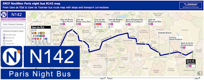
Paris Noctilien night bus N142 map with stops and transport connections
Additionally, the N142 night bus line also stops at Republique for the Bataclan and travelling between Gare de l'Est and Tournan this Noctilien route goes through many different communes, or areas of the Paris region including Fontenay sous Bois, Le Perreux sur Marne, Roissy en Brie and Gretz Armainvilliers, etc.
Paris night bus line N142 stops:
Gare de l'Est - Rue du 8 Mai 1945, Republique - Place de la Republique, Porte de Bagnolet - Place de la Porte de Bagnolet, Gare de Rosny-Bois-Perrier RER, Gare de Rosny-Sous-Bois RER, Gare de Val de Fontenay RER, Gare de Nogent Le Perreux RER, Gare d'Emerainville - Pontault-Combault - Place Beilstein, Gare de Roissy en Brie - Place de la Gare, Aristide Briand, Campus Sainte-Therese, Gare de Gretz Armainvilliers, Gare de Tournan.
Paris night bus line N142 main transport connections:
Paris Open Tour bus sightseeing tour map for Blue, Red and Green bus lines with stops and timetables
If you would like to see more of Paris before a concert or other event at the Bataclan, then you could take advantage of Open Tour that are company who operate hop on and hop off bus tours around the city with three different routes that you can discover in their entirety or just picking places you wish to stop at. So you will find that it is the Red Tour and Stop 35 called Republique, which faces 11 Boulevard Saint-Martin, 75003, Paris that is closest to this particular entertainment venue.
1: Haussmann - Opera - Visitor centre - 13 Rue Auber, 75009 30: Trinite - 32 Rue Mogador, 75009 31: Moulin Rouge - Pigalle - 59 Boulevard de Clichy, 75009 32: Montmartre - Sacre-Coeur - 68 Boulevard de Rochechouart, 75018 33: Gare du Nord - 21 Rue de Dunkerque, 75010 34: Gare de l'Est - 129 Rue du Faubourg St-Martin, 75010 35: Republique - Face au 11 Boulevard Saint-Martin, 75003 36: Bonne Nouvelle - Grand Rex - 36 Boulevard de Bonne-Nouvelle, 75010 37: Grands Boulevards - Hard Rock Cafe - 16 Boulevard Montmartre, 75009
Paris Open Tour bus sightseeing tour maps with stops and timetables:
Bataclans new artistic project and visual identity
So here you can see a press release by Bataclan that provides information about their vision for the future to incorporate numerous different forms of entertainment and events that will take place at this iconic venue in Paris, whether it be comedy, dance, concerts, exhibitions, conferences and more, through their artistic project showcasing and creating art.
Paris Bataclans new artistic project info available:
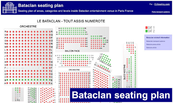
This shows the general seating plan for Bataclan with the ticket categories and the various areas of seating such as the balconies, mezzanine areas and the main orchestra section, which like any entertainment venue laid out like a theatre, is most prominent and best seating you can normally get.