How to get to Le Grand Rex in Paris using public transport
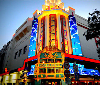
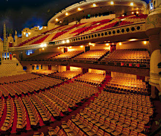
Located within an historical building, the Grand Rex is not just a cinema and the largest in Paris, but it is also a major entertainment venue often seeing international stars, as there is a large concert hall that seats over 2,700 people, not forgetting the Rex Club nightclub where you can party to an electro beat. So below, you can discover how to get to the Grand Rex with maps, public transport timetables and even a seating plan for this event venue, which can all be downloaded by PDF or image formats to your PC or mobile device.
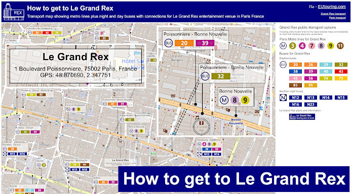
Grand Rex transport map of Metro lines, bus lines with stops, connections and street plan
Here you can see a street plan with the location of Grand Rex along with all the various Paris public transport options that are within walking distance of this entertainment venue, which includes Metro stations and bus stops for the various day and night buses that will get you to or from the Grand Rex.
How to get to Le Grand Rex public transport maps available:
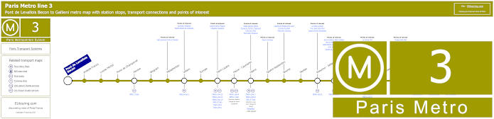
Paris Metro Line 3 map with stations, connections and points of interest
This shows the maps for the Paris Metro line 3 that travels between Pont de Lavallois - Becon and Gallieni close to the Parc de Bagnolet, and as you can see, this is one of the options for how to get to Palais Garnier Opera House via the Opera stop, as well as the Grand Rex via the Sentier Metro stop, which is around a 450 metres walk.
Metro Line 3 stops:
Pont de Levallois Becon, Anatole France, Louise Michel, Porte de Champerret, Pereire, Wagram, Malasherbes, Villiers, Europe, Saint-Lazare, Havre - Caumartin, Opera, Quatre-Septembre, Bourse, Sentier, Reaumur - Sebastopol, Arts et Metiers, Temple, Republique, Parmentier, Rue Saint-Maur, Pere Lachaise, Gambetta, Porte de Bagnolet, Gallieni.
Metro line 3 main transport connections:
Metro Lines: 2, 3b, 4, 5, 7, 8, 9, 11, 12, 13, 14. Train Lines, A, C, E , J, L. Tram Line: T3b. Bus Line: RoissyBus.
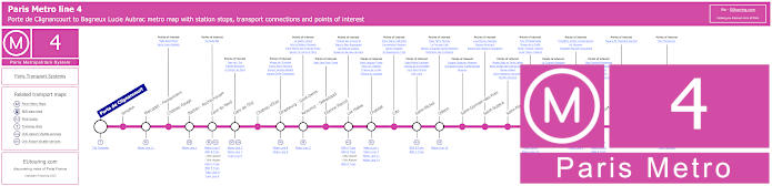
Paris Metro Line 4 map with stations, connections and points of interest
Although the Strasbourg - Saint-Denis Metro stop is a walk of approximately 350 metres to the Grand Rex entertainment venue on the Paris Metro line 4, and travelling between Porte de Clignancourt and Bagneux Lucie Aubrac, you will also find that this line also goes to Gare de Nord train station where the Eurostar along with many other trains arrive in Paris.
Metro line 4 stops:
Porte de Clignancourt, Simplon, Marcadet - Poissonniers, Chateau Rouge, Barbes - Rochechouart, Gare du Nord, Gare de l'Est, Chateau d'Eau, Strasbourg - Saint-Denis, Reaumur - Sebastopol, Etienne Marcel, Les Halles, Chatelet, Cite, Saint-Michel, Odeon, Saint-Germain-des-Pres, Saint-Sulpice, Saint-Placide, Montparnasse - Bienvenue, Vavin, Raspail, Denfert-Rochereau, Mouton-Duvernet, Alesia, Porte d'Orleans, Mairie de Montrouge, Barbara, Bagneux Lucie Aubrac.
Metro line 4 main transport connections:
Metro Lines: 1, 2, 3, 5, 6, 7, 8, 9, 10, 11, 12, 13, 14. Train Lines: A, B, C, D, E, H, K, N, P. Tram Lines: T3a, T3b. Bus Line: OrlyBus.
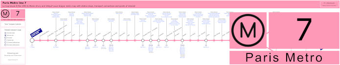
Paris Metro Line 7 map with stations, connections and points of interest
The Metro line 7 starts from La Courneuve - 8 Mai 1945 travelling through to Maison Blanche where the line splits and goes to two different terminuses being Mairie d'Ivry and Villejuif - Louis Aragon and for getting to the Grand Rex you could alight at the Cadet Metro station or the Le Peletier Metro station, both of which are around a 900 metre walk to this popular cinema, club and concert venue.
Metro line 7 stops:
La Courneuve - 8 Mai 1945, Fort d'Aubervilliers, Aubervilliers - Pantin - Quatre Chemins, Porte de la Villette, Corentin Cariou, Crimee, Riquet, Stalingrad, Louis Blanc, Chateau-Landon, Gare de l'Est, Poissonniere, Cadet, Le Peletier, Chaussee d'Antin - La Fayette, Opera, Pyramides, Palais Royal - Musee du Louvre, Pont Neuf, Chatelet, Pont Marie, Sully - Morland, Jussieu, Place Monge, Censier - Daubenton, Les Gobelins, Place d'Italie, Tolbiac, Maison Blanche, Porte d'Italie, Porte de Choisy, Porte d'Ivry, Pierre et Marie Curie, Mairie d'Ivry, Le Kremlin-Bicetre, Villejuif - Leo Lagrange, Villejuif - Paul Vaillant-Couturier, Villejuif - Louis Aragon.
Metro line 7 main transport connections:
Metro Lines: 1, 2, 3, 4, 5, 6, 7bis, 8, 9, 10, 11, 14. Train Lines: A, B, D, E, P. Tram Lines: T1, T3a, T3b, T7. Bus Line: RoissyBus.
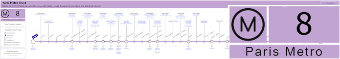
Paris Metro Line 8 map with stations, connections and points of interest
Whereas the Paris Metro line 8 travels between Balard and Creteil - Pointe du Lac, with the Bonne Nouvelle Metro stop being the closest to Grand Rex and is one option for getting to Les Invalides to discover the historical complex along with other Paris tourist attractions located close by.
Yet, as a point of interest, if you walk a little further to the Richelieu - Drouot Metro station, located within the ticket hall you can discover a black marble monument dedicated to the metropolitan railway employees who died fighting during World War I. It was created in 1931 by the sculptor Carlo Sarrabezolles, who was also a soldier in the WWI, which was designed as a half-moon shaped work with a caryatid holding up an archway in the middle, and underneath are written the names of employees lost in the war, along with the names of the battles fought.
Metro line 8 stops:
Balard, Lourmel, Boucicaut, Felix Faure, Commerce, La Motte-Picquet - Grenelle, Ecole Militaire, La Tour-Maubourg, Invalides, Concorde, Madeleine, Opera, Richelieu-Drouot, Grands Boulevards, Bonne Nouvelle, Strasbourg - Saint-Denis, Republique, Filles du Calvaire, Saint-Sebastien - Froissart, Chemin Vert, Bastille, Ledru-Rollin, Faidherbe - Chaligny, Reuilly - Diderot, Montgallet, Daumesnil, Michel Bizot, Porte Doree, Porte de Charenton, Liberte, Charenton - Ecoles, Ecole Veterinaire de Maisons-Alfort, Maisons-Alfort - Stade, Maisons-Alfort - Les Juilliottes, Creteil - L'Echat, Creteil - Universite, Creteil - Prefecture, Creteil - Pointe du Lac.
Metro line 8 main transport connections:
Metro Lines: 1, 3, 4, 5, 6, 7, 9, 10, 11, 12, 13, 14. Train Lines: A, C. Tram Lines: T2, T3a. Bus Lines: RoissyBus, TVM (14).
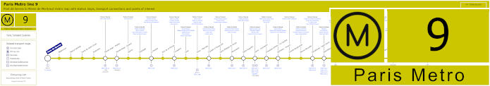
Paris Metro Line 9 map with stations, connections and points of interest
You will find that just like above, the Metro line 9 has a stop at Bonne Nouvelle, which is the closed Metro station to the Grand Rex cinema and concert venue, and travelling between Pont de Sevres and Mairie de Montreuil, there are numerous transport connections on route including at Republique and Nation, not forgetting the Porte de Saint-Cloud stop for how to get to Parc des Princes stadium.
Metro line 9 stops:
Pont de Sevres, Billancourt, Marcel Sembat, Porte de Saint-Cloud, Exelmans, Michel-Ange - Molitor, Jasmin, Ranelagh, La Muette, Rue de la Pompe, Trocadero, Iena, Alma - Marceau, Franklin D Roosevelt, Saint-Philippe-du-Roule, Miromesnil, Saint-Augustin, Havre - Caumartin, Chaussee d'Antin - La Fayette, Richelieu - Drouot, Grands Boulevards, Bonne Nouvelle, Strasbourg - Saint-Denis, Republique, Oberkampf, Saint-Ambrose, Voltaire, Charonne, Rue des Boulets, Nation, Buzenval, Maraichers, Porte de Montreuil, Robespierre, Croix de Chavaux, Mairie de Montreuil.
Metro line 9 main transport connections:
Metro Lines: 1, 2, 3, 4, 5, 6, 7, 8, 10, 11, 13, 14. Train Lines: A, C, E. Tram Lines: T2, T3b. Bus Line: RoissyBus.
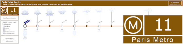
Paris Metro Line 11 map with stations, connections and points of interest
Whereas here you have the Paris Metro line 11 that travels from Chatelet, which is a way of getting to Le Duc des Lombards Jazz Club and other entertainment venues, and travelling through to Mairie des Lilas, you would need the Arts et Metiers stop for getting to Grand Rex, which is a walking distance of approximately 1100 metres.
Bus as another point of interest, the Metro line 11 platforms were re-designed back in 1994 by Belgium artist Francois Schuiten to be based upon the books of Jules Verne providing a submarine decor with 800 studded copper wall panels along with a panel of gears, pulleys, and cogs on the vaulted ceiling to look like a machine, in addition to 11 brass-framed portholes positioned along the platform, which contain miniature exhibits of old and new contraptions that appear in the Musee des Arts et Metiers collections such as a water turbine.
Metro line 11 stops:
Chatelet, Hotel de Ville, Rambuteau, Arts et Metiers, Republique, Goncourt, Belleville, Pyrenees, Jourdain, Place des Fetes, Telegraphe, Porte des Lilas, Mairie des Lilas.
Metro line 11 main transport connections:
Metro Lines: 1, 2, 3, 3bis, 4, 5, 7, 7bis, 8, 9, 14. Train Linea: A, B, D. Tram Line: T3b.
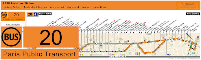
RATP Paris bus line 20 with stops, connections and street plan
So here we have the Paris bus line 20 run by the transport company RATP that travels between Louison Bobet and Porte des Lilas, however, please do look at the maps and timetables very carefully as there are numerous bus stops only served in one direction, which means that for getting to the Grand Rex you would need to Poissonniere - Bonne Nouvelle stop in one direction or the Sentier stop in the other.
Paris bus line 20 stops:
Louison Bobet, Alsace**, Curnonsky*, Reims - Hotel des Impots*, Porte d’Asnieres - Marguerite Long, Juliette Lamber, Wagram - Pereire, Jouffroy d’Abbans - Malesherbes, Place du General Catroux, Malesherbes - Courcelles, Lisbonne - Mairie du 8e, Saint-Augustin, Gare Saint-Lazare*, Pasquier - Anjou*, Havre - Haussmann, Auber, Opera, Opera - Quatre Septembre**, Choiseul*, Richelie - Drouot*, Richelieu - Quatre Septembre**, Bourse**, Grands Boulevards*, Reaumur - Montmartre**, Poissonniere - Bonne Nouvelle*, Sentier**, Porte Saint-Denis*, Reaumur - Sebastopol**, Reaumur - Arts et Metiers**, Porte Saint-Martin*, Arts et Metiers**, Square du Temple**, Lancry - Saint-Martin*, Turbigo - Republique**, Republique - Magenta**, Republique, Ferry - Lenoir**, Jules Ferry*, Parmentier - Republique**, Goncourt*, Saint-Maur - Jean Aicard**, Belleville - Menilmontant**, Couronnes**, Faubourg du Temple - Piver*, Ramponeau**, Belleville, Julien Lacroix, Pyrenees - Belleville, Jourdain, Rue des Fetes, Pixerecourt, Pelleport - Belleville, Haxo, Porte des Lilas Metro, Porte des Lilas.
* Served in direction of Louison Bobet. ** Served in direction of Porte des Lilas.
Paris bus line 20 main transport connections:
Metro Lines: 2, 3, 3bis, 4, 5, 7, 8, 9, 11, 12, 13, 14. Train Lines: A, E, J, L. Tram Line: T3b.
RATP Paris bus line 26 with stops, connections and street plan
Yet this shows the maps and timetables for the Paris bus line 26 that goes from Gare Saint-Lazare train station through to Nation - Trone, but just like above please check the bus route out very carefully as the Cadet stop on travels in one direction, whereas the Carrefour de Chateaudun bus stop goes in both directions, which is approximately 950 metres from the Grand Rex.
Paris bus line 26 stops:
Gare Saint-Lazare, Gare Saint-Lazare - Budapest*, Trinite, St-Georges - Chateaudun, Carrefour de Chateaudun, Chateaudun - Lamartine*, Cadet*, Maubeuge - Rochechouart*, Square Montholon*, Condorcet*, Place Franz Liszt*, Magenta - Maubeuge*, La Fayette - St-Quentin - Gare du Nord*, Gare du Nord - Dunkerque*, La Fayette - Dunkerque, Chateau Landon, Louis Blanc*, Jaures - Stalingrad*, Marche Secretan, Mathurin Moreau - S. Bolivar, Atlas, Botzaris - Buttes Chaumont, Pyrenees - Belleville, Jourdain, L'Ermitage, Pyrenees - Menilmontant, Villiers de l'Isle Adam, Gambetta - Pyrenees, Ramus, Pyrenees - Bagnolet, Orteaux, Maraichers, La Plaine, Cours de Vincennes, Marsoulan, Nation - Trone.
* Stop only served in a particular direction.
Paris bus line 26 main transport connections:
Metro Lines: 1, 2, 3, 3bis, 4, 5, 6, 7, 7bis, 9, 11, 12, 13, 14. Train Lines: A, B, D, E, H, J, K, L, P. Tram Lines: T3a, T3b.
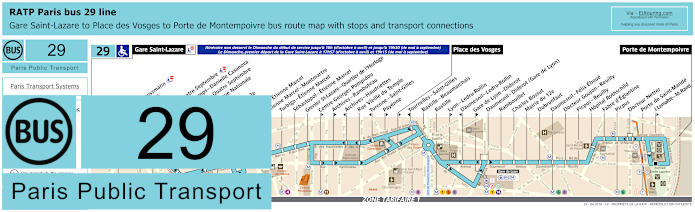
RATP Paris bus 29 map with stops, connections and street plan
However, here you have the maps for RATP bus line 29 that travels from Porte de Montempoivre to Gare Saint-Lazare, yet on a Sunday the route only travels through to Place des Vosges until early evening, and for the Grand Rex you would need the Bourse stop if travelling from the Gare Saint-Lazare train station or the Victoires bus stop, which is a little further walk, but goes in both directions.
Paris bus line 29 stops:
Gare Saint-Lazare, Havre - Haussmann, Auber, Opera, Opera - Quatre Septembre, Petits Champs - Danielle Casanova**, Richelieu - Quatre Septembre*, Bibliotheque Nationale**, Bourse*, Mairie du 2e*, Victoires, Louvre - Etienne Marcel**, Etienne Marcel - Montmartre, Turbigo - Etienne Marcel, Sebastopol - Etienne Marcel, Grenier St-Lazare - Quartier de l’Horloge, Centre Georges Pompidou*, Archives - Rambuteau*, Archives - Haudriettes**, Rue Vieille du Temple, Turenne - Saint-Gilles**, Payenne*, Place des Vosges*, Tournelles-Saint-Gilles**, Bastille - Beaumarchais, Bastille, Lyon - Ledru-Rollin*, Daumesnil - Ledru-Rollin**, Gare de Lyon - Diderot*, Daumesnil - Diderot (Gare de Lyon), Rambouillet, Charles Bossut, Mairie du 12e, Dubrunfaut, Daumesnil - Felix Eboue, Docteur Goujon - Reuilly, Picpus - Reuilly, Hopital Rothschild, Fabre d’Eglantine, Picpus, Docteur Netter, Porte de Saint-Mande, J. Lemaitre - M. Ravel*, Porte de Montempoivre.
* Served in direction of Porte de Montempoivre. ** Served in direction of Gare Saint-Lazare.
Paris bus line 29 main transport connections:
Metro Lines: 1, 3, 4, 5, 6, 7, 8, 9, 11, 12, 13, 14. Train Lines: A, D, E, J, L, R. Tram Line: T3a.
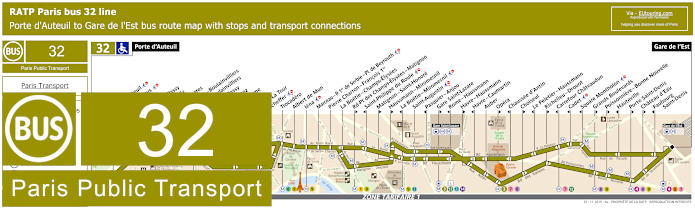
RATP Paris bus line 32 with stops, connections and street plan
The bus line 32 is one of the options for how to get to Hippodrome de Longchamp horse racing course at it goes from the Porte d'Auteuil through to Gare de l'Est train station, yet like many other Paris buses, the maps with their timetables show many stops that are direction dependant and for getting to the Grand Rex entertainment venue you would need the Poissonniere - Bonne Nouvelle stop in one direction or the Hauteville stop a little further walk away if travelling in the other direction.
Paris bus line 32 stops:
Porte d'Auteuil, Gare d’Auteuil**, Alfred Capus, Raffet, Porte de Passy, Louis Boilly**, Avenue Ingres*, La Muette - Boulainvilliers, Passy - Boulainvilliers**, Place de Passy**, Place Possoz*, Jean Bologne**, La Tour*, Passy - La Tour**, Scheffer, Trocadero, Albert de Mun, Iena, Marceau - P. 1er de Serbie - Pl. de Beyrouth, Pierre Charron - Francois 1er, La Boetie - Champs-Elysees, Rd-Pt des Champs-Elysees - Matignon**, Saint-Philippe du Roule*, Matignon - Saint-Honore**, Haussmann - Miromesnil**, La Boetie - Miromesnil*, Saint-Augustin, Pasquier - Anjou*, Gare Saint-Lazare**, Rome - Haussmann*, Havre - Haussmann**, Havre - Caumartin*, Auber, Opera**, Chaussee d'Antin*, Choiseul**, Le Peletier - Haussmann*, Richelieu - Drouot**, Carrefour Chateaudun*, Cadet*, Square Montholon*, Grands Boulevards**, Poissonniere - Bonne Nouvelle**, Hauteville*, Porte Saint-Denis**, Chateau d’Eau**, Faubourg - Saint-Denis*, Gare de l'Est.
* Stop served in direction of Porte d'Auteuil. ** Stop served in direction of Gare de l'Est.
Paris bus line 32 main transport connections:
Metro Lines: 1, 3, 4, 5, 6, 7, 8, 9, 10, 12, 13, 14. Train Lines: C, E, J, L, P.
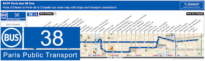
RATP Paris bus line 38 with stops, connections and street plan
Here you have the RATP bus line 38 and as you can see from the street maps and the timetables it stops at tourist attractions like Centre Georges Pompidou and many others, but for the Grand Rex you would need the Strasbourg - Saint-Denis bus stop going in the direction of Porte de la Chapelle or the Reaumur - Arts et Metiers stop going in travelling in the direction of Porte d'Orleans.
Paris bus line 38 stops:
Porte d'Orleans, Alesia - General Leclerc, Alesia - Maine*, Mouton - Duvernet, Denfert-Rochereau - Daguerre**, Denfert-Rochereau*, Denfert-Rochereau - Arago, Hopital Saint-Vincent de Paul, Observatoire - Port-Royal, Val de Grace, Auguste Comte, Luxembourg, Les Ecoles, Saint-Michel - Saint-Germain, Cite - Palais de Justice, Chatelet, Coutellerie*, Les Halles - Centre Georges Pompidou**, Centre Georges Pompidou*, Turbigo - Etienne Marcel**, Grenier St-Lazare - Quartier de l’Horloge*, Reaumur - Arts et Metiers*, Reaumur - Sebastopol**, Strasbourg - Saint-Denis**, Porte Saint-Martin*, Chateau d’Eau**, Mairie du 10e*, Magenta - Saint-Martin*, Gare de l’Est, Valenciennes, Gare du Nord, Cail-Demarquay, Place de la Chapelle, Departement-Marx Dormoy, Ordener - Marx Dormoy, Les Roses, Boucry, Porte de la Chapelle.
*Stops served in direction of Porte d'Orleans. ** Stops served in direction of Porte de la Chapelle.
Paris bus line 38 main transport connections:
Merto Lines: 1, 2, 3, 4, 5, 6, 7, 8, 9, 11, 12, 14. Train Lines: A, B, C, D, E, H, K, P. Tram Lines: T3a, T3b.
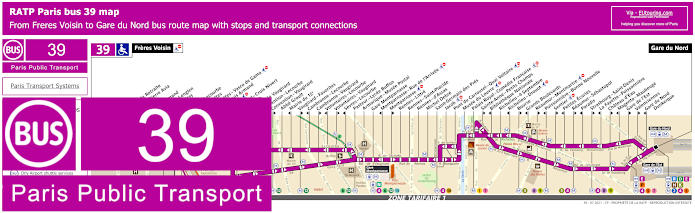
RATP Paris bus line 39 with stops, connections and street plan
Travelling from ticket tariff zone 2 at Freres Voisin the RATP bus line 39 goes into the heart of Paris to Gare de Nord train station in tariff zone 1, and again as you can see from the maps and timetables, you would need the Poissonniere - Bonne Nouvelle stop in one direction. Yet for travel the opposite way, you could alight at the Sentier or the Strasbourg - Saint-Denis stop.
Paris bus line 39 stops:
Freres Voisin, Maison de Retraite**, Colonel Pierre Avia*, Severine**, Louis Armand*, Suzanne Lenglen*, Porte d’Issy**, Balard*, Balard - Lecourbe*, Desnouettes**, Desnouettes - Vasco de Gama**, Lycee Louis Armand*, Hameau**, Duranton**, Hopital de Vaugirard**, Convention - Lecourbe*, Convention - Vaugirard**, Abbe Groult, Mairie du 15e*, Vaugirard - Favorites**, Cambronne - Lecourbe*, Cambronne - Vaugirard**, Volontaires - Lecourbe*, Volontaires - Vaugirard**, Sevres - Lecourbe*, Pasteur - Lycee Buffon, Armorique - Musee Postal, Gare Montparnasse, Montparnasse - Rue de l’Arrivee*, Montparnasse**, Rennes - Littre, Rennes - Saint-Placide, Rennes - d’Assas, Michel Debre, Saint-Germain des Pres, Jacob, Pont du Carrousel - Quai Voltaire, Musee du Louvre, Palais Royal - Comedie Francaise, Sainte-Anne - Petits Champs**, Bibliotheque Nationale*, Richelieu - 4 Septembre, Richelieu - Drouot*, Bourse**, Grands Boulevards*, Reaumur - Montmartre**, Poissonniere - Bonne Nouvelle*, Sentier**, Petites Ecuries*, Reaumur - Sebastopol**, Paradis*, Strasbourg - Saint-Denis**, La Fayette - Poissonniere*, Chateau d'Eau**, Magenta - Maubeuge*, Gare de l'Est**, Valenciennes**, Gare du Nord - Dunkerque*, Gare du Nord.
* Served in the direction of Freres Voisin ** Served in the direction of Gare du Nord
Paris bus line 39 main transport connections:
Metro lines: 1, 2, 3, 4, 5, 6, 7, 8, 9, 10, 12, 13. Train lines: B, D, E, H, K, N, P. Tram lines: T2, T3a.
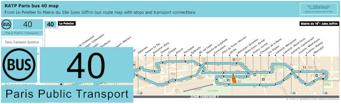
RATP Paris bus line 40 with stops, connections and route plan
The bus line 40 is actually what took over from the Montmartrobus, which is how to get to Sacre Cour Basilica plus many other attractions and Paris entertainment venues including the Grand Rex by utilising its terminus point of Le Peletier, which goes through to Mairie du 18e - Jules Joffrin, although we would also like to point out that unfortunately this is not a disabled accessible bus route at present.
Paris bus line 40 stops:
Le Peletier, Carrefour de Chateaudun, Saint-Georges - Chateaudun, Saint-Georges, Gustave Toudouze, Navarin, Rochechouart - Martyrs, Pigalle, Martyrs, Orsel, Abbesses, Yvonne Le Tac, Durantin - Burq, Tholoze, Chappe, Drevet, Tourlaque, Gabrielle, 88, rue Lepic, Moulin de la Galette, Funiculaire, Place du Tertre - Norvins, Utrillo, Abreuvoir - Girardon, Mont-Cenis - Cortot, Saules - Cortot, Chevalier de la Barre, Les Vignes, Lamarck - Becquerel, Lamarck - Mont-Cenis, Lamarck - Caulaincourt, Custine - Mont-Cenis, Custine - Ramey, Marcadet, Mairie du 18e - Jules Joffrin.
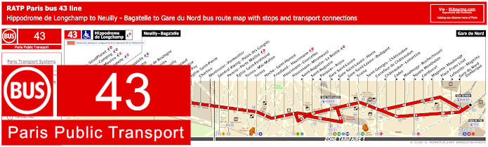
RATP Paris bus line 43 with stops, connections and street plan
Just like the bus 26, for getting to the Grand Rex concert hall, cinema or its club via the Paris bus line 43, you would need the Cadet stop if travelling in the direction of Gare du Nord or the Carrefour de Chateaudun stop in either direction including to the opposite terminus of Neuilly - Bagatelle or further on to the Hippodrome de Longchamp at weekends, but line 43 is also how to get to Palais des Congres event venue via the General Koenig - Palais des Congres bus stop.
Paris bus line 43 stops:
Hippodrome de Longchamp*, Longchamp - GoodPlanet**, Les Moulins - Camping* ***, Route des Moulins* ***, Parc de Bagatelle*, Neuilly - Bagatelle, Place de Bagatelle, Rue du Centre, Rue du Bois de Boulogne, Maurice Barres, Pont de Neuilly, General Gouraud, Rue de l’Eglise**, Sainte-Foy, Eglise Saint-Pierre, Chartres, Montrosier - Parmentier, General Koenig - Palais des Congres, Pereire - Porte Maillot, Eglise Saint-Ferdinand, Ternes - Mac-Mahon, Ternes, Hoch - Saint-Honore, Friedland - Haussmann, Haussmann - Courcelles, Haussmann - Miromesnil, Saint-Augustin - La Boetie***, Saint-Augustin**, Pasquier - Anjou***, Gare Saint-Lazare**, Gare Saint-Lazare - Havre***, Gare Saint-Lazare - Budapest***, Trinite, Saint-Georges - Chateaudun, Carrefour de Chateaudun, Chateaudun - Lamartine***, Cadet**, Maubeuge - Rochechouart***, Square Montholon**, Condorcet***, Magenta - Maubeuge***, Place Franz Liszt**, Lafayette - Magenta**, Gare du Nord - Dunkerque***, Gare du Nord.
* Stop only served on a Saturday and Sunday. ** Served in the direction of Gare du Nord. *** Served in the direction of Neuilly - Bagatelle / Hippodrome de Longchamp.
Paris bus line 43 main transport connections:
Metro Lines: 1, 2, 3, 4, 5, 7, 9, 12, 13, 14. Train Lines: B, C, D, E, J, L.
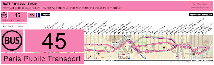
RATP Paris bus line 45 with stops, connections and street plan
Yet this is the same scenario as above where the RATP bus line 45 has many stops that are direction dependant including the Cadet stop if travelling in the direction of Aubervilliers - France-Asie or the Carrefour de Chateaudun stop while travelling in the direction of Concorde when you are looking at getting to or from the Grand Rex, so please take note of the maps with their timetables very carefully, although getting to Madeleine church and square is the same either way.
Paris bus line 45 stops:
Concorde, Concorde - Royale**, Madeleine - Malesherbes*, Madeleine, Capucines - Caumartin, Opera - Scribe*, Opera**, Chaussee d'Antin, Saint-Georges - Provence**, Le Peletier**, Le Peletier - Haussmann*, Carrefour de Chateaudun*, Chateaudun - Lamartine*, Cadet**, Maubeuge - Rochechouart*, Square Montholon**, Condorcet*, Magenta - Maubeuge*, Place Franz Liszt**, La Fayette - Magenta**, Gare du Nord - Dunkerque*, Gare du Nord, Cail - Demarquay, Place de la Chapelle, Philippe de Girard**, Chapelle - Caillie*, Chateau Landon**, Place du Maroc**, Maroc*, Riquet*, Curial - Archereau**, Mathis**, Radiguet*, Curial - Crimee**, Crimee - Rosa Parks**, Crimee - Aubervilliers*, Evangile - Aubervilliers, Porte d'Aubervilliers - Macdonald, Skanderbeg, Parc du Millenaire, Jardin des Berges, Rue de La Hale Coq*, Quai Lucien - Lefranc**, Aubervilliers - France-Asie.
* Stop served in the direction of Concorde. ** Stop served in the direction of Aubervilliers - France-Asie.
Paris bus line 45 main transport connections:
Metro Lines: 1, 2, 3, 4, 5, 7, 8, 9, 12, 14. Train Lines: A, B, D, E, H, K. Tram Line: T3b.
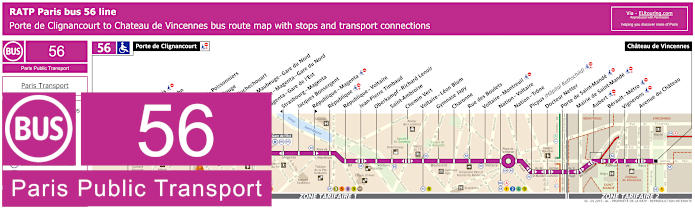
RATP Paris bus line 56 with stops, connections and street plan
Now this is one of the ways for how to get to Chateau de Vincennes being it is one of the Paris bus line 56 terminus points, yet this is also an option for getting to Bataclan via the Jean-Pierre Timbaud bus stop as you can see from the street maps and timetables, yet for the Grand Rex we would like to point out that you can only use this line using the Strasbourg - Magenta stop in the direction of Porte de Clignancourt unless walking even further to the Jacques Bonsergent stop.
Paris bus line 56 stops:
Porte de Clignancourt, Mont-Cenis*, Albert Kahn, Simplon, Marcadet - Poissonniers, Chateau Rouge, Barbes - Rochechouart, Magenta - Maubeuge - Gare du Nord, La Fayette - Magenta - Gare du Nord, Magenta - Gare de l’Est, Strasbourg - Magenta*, Jacques Bonsergent, Republique - Magenta*, Republique, Republique - Voltaire, Jean-Pierre Timbaud, Oberkampf - Richard Lenoir, Saint-Ambroise, Chemin Vert, Voltaire - Leon Blum, Gymnase Japy, Charonne, Rue des Boulets, Voltaire - Montreuil, Nation - Voltaire, Nation - Trone, Picpus (Hopital Rothschild), Docteur Netter, Porte de Saint-Mande, Mairie de Saint-Mande, Aubert, Berault - Metro, Vignerons, Avenue du Chateau, Chateau de Vincennes.
* Bus stop is direction dependant.
Paris bus line 56 main transport connections:
Metro Lines: 1, 2, 3, 4, 5, 6, 8, 9, 11, 12. Train Lines: A, B, D, E, H, K. Tram Line: T3b.
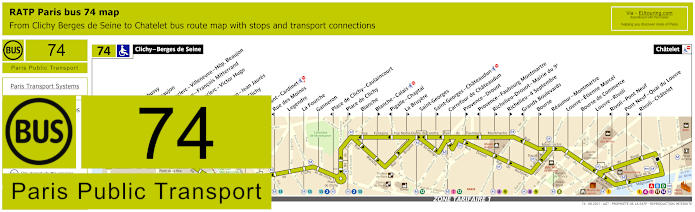
RATP Paris bus line 74 with stops, connections and street plan
However, the bus line 74 goes from Clichy - Berges de Seine, also within ticket tariff zone 2 as you will see from the maps and timetables, and this route goes though to one of the main Paris public transport hubs of Chatelet where you can get many transport connections, but for the Grand Rex event venue you would need the Richelieu - Drouot - Mairie du 9e stop in the direction of Chatelet or the Carrefour de Chateaudun stop that travels in either direction.
Paris bus line 74 stops:
Clichy - Berges de Seine, Claude Debusy**, Hopital Beaujon, General Leclerc - Villeneuve - Hop. Beaujon, Republique - Francois Mitterrand, General Leclerc - Victor Hugo, Curton, Victor Hugo - Jean Jaures, Porte de Clichy, Boulay, Brochant - Cardinet, Rue des Moines*, Legendre, La Fourche, Ganneron, Place de Clichy - Caulaincourt*, Place de Clichy**, Blanche, Blanche - Calais**, Pigalle - Chaptal*, La Bruyere**, Saint-Georges, Saint-Georges - Chateaudun**, Carrefour de Chateaudun, Provence - Drouot**, Provence - Faubourg Montmartre*, Richelieu - Drouot - Mairie du 9e**, Richelieu - 4 Septembre**, Grands Boulevards*, Bourse**, Reaumur - Montmartre, Louvre - Etienne Marcel, Bourse de Commerce, Louvre - Rivoli, Rivoli - Pont Neuf*, Pont Neuf - Quai du Louvre**, Rivoli - Chatelet*, Chatelet.
* Stop served in direction of Clichy - Berges de Seine. ** Stop served in direction of Chatelet.
Paris bus line 74 main transport connections:
Metro Lines: 1, 2, 3, 4, 7, 8, 9, 11, 12, 13, 14. Train Lines: A, B, C, D. Tram Line: T3b.
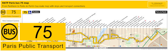
RATP Paris bus line 75 with stops, connections and street plan
Travelling from the Pantheon, the bus line 75 is one option for how to get to Zenith Paris utilising the other terminus of Porte de Pantin, but you could also utilise this bus route for getting to Grand Rex via the Arts et Metiers stop if travelling in the Pantheon direction, but a further walk along the Rue de Turbigo close to the Temple Metro station and you have the Turbigo - Republique stop that travels in both directions, as you can see from the bus maps and timetables.
Paris bus line 75 stops:
Pantheon, Lycee Henri IV**, Cardinal Lemoine - Monge**, Saint-Jacques - Saint Germain*, Institut du Monde Arabe*, Pont de l’Archeveche**, Petit Pont*, Quai aux Fleurs - Pont St-Louis**, Cite - Parvis Notre-Dame*, Pont d’Arcole**, Hotel de Ville**, Coutellerie*, La Verrerie**, Centre Georges Pompidou*, Archives - Rambuteau**, Grenier Saint-Lazare - Quartier de l’Horloge*, Archives - Haudriettes*, Square du Temple**, Arts et Metiers*, Turbigo - Republique, Republique - Magenta**, Republique*, Jules Ferry, Goncourt*, Alibert, Avenue Richerand**, Hopital Saint-Louis, Grange aux Belles - Juliette Dodu*, Sambre et Meuse**, Colonel Fabien, Mathurin Moreau - Simon Bolivar, Secretan - Buttes Chaumont, Jean Menans - Buttes Chaumont, Armand Carrel - Mairie du 19e, D’Hautpoul, Rhin et Danube, Lycee Diderot, Porte Brunet, General Cochet, Porte Chaumont, Marseillaises - Cheminets, Porte de Pantin - Marseillaise, Porte de Pantin.
* Stop served in direction of Pantheon. ** Stop served in direction of Porte de Pantin.
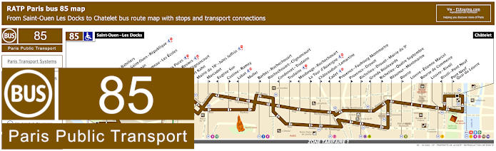
RATP Paris bus line 85 with stops, connections and street plan
Although you will find that the bus line 85 travels from Chatelet, which is ideal for getting to Theatre du Chatelet and the route goes through to Saint-Ouen - Les Docks, and as you can see from the maps and timetables there are several bus stops only served in a particular direction including Cadet for getting to Grand Rex, otherwise you would need the Chateaudun - Lamartine stop that is an additional few minutes walk away.
Paris bus line 85 stops:
Saint-Ouen - Les Docks, Parvis des Bateliers, Mairie de Saint-Ouen - Republique, Ernest Renan, Eugene Lumeau - Les Ecoles, Paul Bert, Marche aux Puces, Michelet - Rosiers, Porte de Clignancourt, Albert Kahn, Mairie du 18e - Jules Joffrin, Marcadet**, Eugene Sue*, Custine - Ramey**, Labat*, Muller, Barbes - Rochechouart**, Rochechouart - Clignancourt, Condorcet - Trudaine*, Trudaine**, Maubeuge - Rochechouart*, La Tour d’Auvergne**, Chateaudun - Lamartine**, Cadet*, Provence - Faubourg Montmartre*, Provence - Drouot**, Richelieu - Drouot - Mairie du 9e**, Grands Boulevards*, Richelieu - Quatre Septembre**, Reaumur - Montmartre, Bourse**, Louvre - Etienne Marcel, Bourse de Commerce, Louvre - Rivoli, Rivoli - Pont Neuf*, Pont Neuf - Quai du Louvre**, Chatelet.
* Stop served in direction of Saint-Ouen - Les Docks. ** Stop served in direction of Chatelet, Paris.
Paris bus line 85 main transport connections:
Metro Lines: 1, 2, 3, 4, 7, 8, 9, 11, 12, 13, 14. Train Lines: A, B, D. Tram Line: T3b.
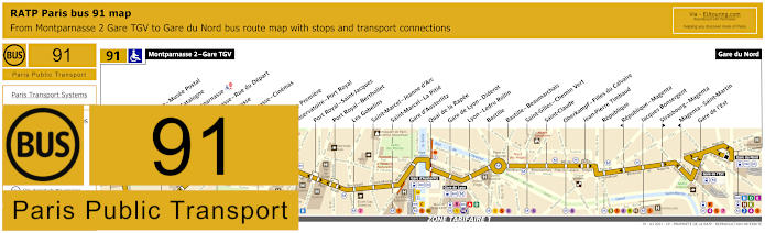
RATP Paris bus 91 map with stops, connections and route plan
Whereas the RATP Paris bus line 91 goes between Gare du Nord and Montparnasse 2 - Gare TGV, which is one option for how to get to Tour Montparnasse but is also great for getting to Bastille and Opera Bastille, yet for the Grand Rex there is the Strasbourg - Magenta bus stop, although we would like to point out that as you can see from the bus maps and timetables, this only goes in the direction of Gare du Nord, so for a stop in the opposite direction you would need to walk a few extra minutes along the Boulevard de Magenta to the Jacques Bonsergent stop.
Paris bus line 91 stops:
Montparnasse 2 - Gare TGV, Armorique - Musee Postal, Place de Catalogne, Gare Montparnasse, Montparnasse - Rue du Depart, Montparnasse, Montparnasse - Cinemas, Vavin, Campagne Premiere, Observatoire - Port Royal, Port Royal - Saint-Jacques, Port Royal - Berthollet, Les Gobelins, Saint-Marcel - Jeanne d'Arc, Saint-Marcel - La Pitie, Gare d'Austerlitz, Quai de la Rapee, Gare de Lyon - Diderot, Lyon - Ledru Rollin, Bastille, Bastille - Beaumarchais, Saint-Gilles - Chemin Vert, Saint-Claude, Oberkampf - Filles du Calvaire, Jean-Pierre Timbaud, Republique, Republique - Magenta, Jacques Bonsergent, Strasbourg - Magenta, Magenta - Saint-Martin, Gare de l'Est, Gare du Nord.
Paris bus line 91 main transport connections:
Metro Lines: 1, 2, 3, 4, 5, 6, 7, 8, 9, 10, 11, 12, 13, 14. Train Lines: A, B, C, D, E, H, K, N, P, R.
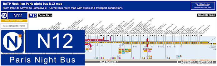
Paris Noctilien night bus N12 map with stops and transport connections
Noctilien are the night buses that operate when other Paris public transport has stopped for the night between approximately 12:30am and 5:30am, and here you can see the maps and timetables for Noctilien line N12, and for getting from or to the Grand Rex you would need the Arts et Metiers stop if travelling in the direction of Pont de Sevres, and the Reaumur - Arts et Metiers stop if going towards Romainville - Carnot.
Paris night bus line N12 stops:
Pont de Sevres, Billancourt, Marcel Sembat, Rene Descartes, Henri Martin, Porte de Saint-Cloud, Porte de Saint-Cloud - Murat, Versailles - Chardon Lagache, Versailles - Exelmans, Victorien Sardou, Wilhem, Pont Mirabeau, Degas, Radio France - Pont de Grenelle, Pont de Grenelle - Maurice Bourdet, Pont de Grenelle - Pl. Fernand Forest, Charles Michels, Avenue Emile Zola, Cambronne, Sevres - Lecourbe, Pasteur - Lycee Buffon, Pasteur - Falguiere, Armorique - Musee Postal, Gare Montparnasse, Montparnasse - Rue de l’Arrivee, Montparnasse, Rennes - Littre, Rennes - Saint-Placide, Rennes - D'Assas, Michel Debre, Bonaparte - Saint-Germain, Saint-Germain-des-Pres, Jacob, Seine - Buci, Pont du Carrousel - Quai Voltaire, Saint-Germain - Odeon, Pont des Arts - Quai de Conti, Pont Neuf - Quai des Grands Augustins, Saint-Michel, Saint-Michel - Saint-Germain, Cite - Palais de Justice, Chatelet, Les Halles - Centre Georges Pompidou, Centre Georges Pompidou, Turbigo - Etienne Marcel, Grenier St-Lazare - Quartier de l’Horloge, Reaumur - Sebastopol, Reaumur - Arts et Metiers, Arts et Metiers, Square du Temple, Turbigo - Republique, Republique, Ferry - Lenoir, Parmentier - Republique, Saint-Maur - Jean Aicard, Jules Ferry, Goncourt, Belleville - Menilmontant, Vouronnes, Belleville, Pyrenees - Belleville, Jourdain, Pixerecourt, Pelleport - Belleville, Porte des Lilas, Les Bruyeres, Mairie des Lilas, Rue de Noisy-le-Sec, Paul de Kock, Joseph Depinay, Gagarine, Cimetiere de Bagnolet, Floreal, Les Noyers, Mairie de Romainville, Gabriel Husson, Romainville - Carnot.
Paris night bus line N12 main transport connections:
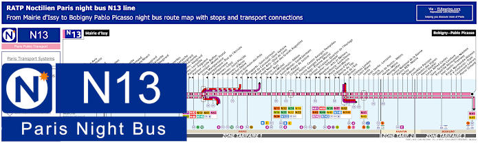
Paris Noctilien night bus N13 map with stops and transport connections
Whereas these maps and timetables show the Noctilien N13 night bus line that travels between Mairie d'Issy and Bobigny - Pablo Picasso, and this route has stops for Paris entertainment venues like getting to the Grande Halle in Parc de la Villette via the Porte de Pantin stop and the Grand Rex via either the Strasbourg - Saint-Denis stop or the Reaumur - Arts et Metiers stop depending upon your direction of travel.
Paris night bus line N13 stops:
Mairie d'Issy, Victor Hugo, Freres Voisin*, Colonel Pierre Avia*, Maison de Retraite**, Severine**, Louis Armand*, Porte d'Issy**, Suzanne Lenglen*, Balard*, Firmin Gillot**, Balard - Lecourbe*, Lycee Louis Armand*, Duranton*, Vaugirard - Croix Nivert**, Hopital de Vaugirard**, Convention - Lecourbe*, Convention - Vaugirard**, Abbe Groult, Mairie du 15e*, Vaugirard - Favorites**, Cambronne - Lecourbe*, Cambronne - Vaugirard**, Volontaires - Lecourbe*, Volontaires - Vaugirard**, Sevres - Lecourbe*, Pasteur - Falguiere**, Pasteur - Lycee Buffon*, Armorique - Musee Postal, Gare Montparnasse, Montparnasse - Rue de l'Arrivee*, Montparnasse**, Rennes - Littre, Rennes - Saint-Placide, Rennes - d'Assas, Michel Debre, Saint-Germain-des-Pres*, Jacob*, Bonaparte - Saint-Germain**, Pont du Carrousel - Quai Voltaire*, Pont des Arts - Quai Conti*, Pont Neuf - Quai des Grands Augustins*, Seine - Buci**, Saint-Michel*, Saint-Germain - Odeon**, Saint-Michel - Saint-Germain**, Cite - Palais de Justice, Chatelet, Les Halles - Centre Georges Pompidou**, Centre Georges Pompidou*, Turbigo - Etienne Marcel**, Grenier St-Lazare - Quartier de l'Horloge*, Reaumur - Sebastopol**, Reaumur - Arts et Metiers*, Strasbourg - Saint-Denis**, Porte Saint-Martin*, Chateau d'Eau**, Mairie du 10e*, Gare de l'Est, Verdun**, Chateau Landon, Louis Blanc, Jaures, Jean Jaures - Lorraine, Ourcq, Porte de Pantin - Metro, Hoche - Metro, Montgolfier, Centre National de la Danse, Pantin RER - Mairie, Delizy, Diderot, Cimetiere Parisien, Chemin des Vignes, Henri Gautier, Lycee Alfred Costes, Gare - Grande Ceinture, Escradille Normandie-Niemen - Jean Jaures - Tramway, Escadrille Normandie-Niemen - Paul Vaillant-Couturier - Tram, Lieutenant Lebrun, Pierre Semard, Bobigny - Pablo Picasso.
* Only served in the direction of Mairie d'Issy. ** Only served in the direction of Bobigny - Pablo Picasso.
Paris night bus line N13 main transport connections:
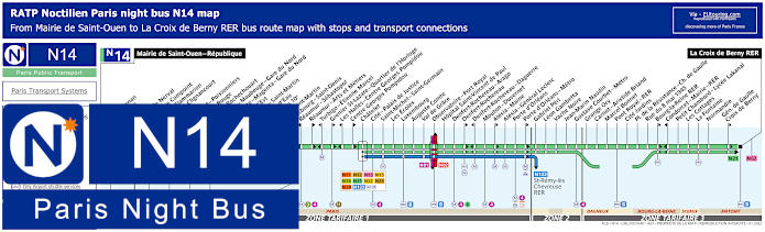
Paris Noctilien night bus N14 map with stops and transport connections
Additionally, you have the night bus line N14 that goes from the Mairie de Saint-Ouen to La Croix de Berny RER with various Noctilien bus connections on route such as at Gare de l'Est train station and just like the route above, you have the Reaumur - Arts et Metiers stop in one direction and the Strasbourg - Saint-Denis night bus stop travelling in the opposite direction for getting to or from the Grand Rex entertainment venue, cinema and club.
Paris night bus line N14 stops:
Mairie de Saint-Ouen - Republique, Ernest Renan, Garibaldi, Kleber, Gerard de Nerval, Angelique Compoint, Camille Flammarion, Porte de Clignancourt, Simplon, Marcadet - Poissonniers, Chateau Rouge, Barbes - Rochechouart, Magenta - Mauberge - Gare du Nord, La Fayette - Magenta - Gare du Nord, Gare de l'Est, Magenta - Saint Martin*, Chateau d'Eau**, Mairie du 10e*, Porte Saint-Martin*, Strasbourg - Saint-Denis**, Reaumur - Sebastopol**, Reaumur - Arts et Metiers*, Turbigo - Etienne Marcel**, Grenier St-Lazare - Quartier de l'Horloge*, Les Halles - Centre Georges Pompidou**, Centre Georges Pompidou*, Chatelet, Cite - Palais de Justice, Saint-Michel - Saint-Germain, Les Ecoles, Luxembourg, Auguste Comte, Val du Grace, Observatoire - Port Royal, Hopital Saint-Vincent de Paul, Denfert-Rochereau -Arago, Denfert-Rochereau*, Denfert-Rochereau - Daguerre**, Mouton - Duvernet, Alesia - Maine*, Alesia - General Leclerc, Porte d'Orleans, Porte d'Orleans - Metro*, Gabriel Peri, Leon Gambetta, Vache Noire, Jean-Marin Naudin, Gustave Courbet - Metro, Grange Ory, Carnot - Aristide Briand, Marcel Bonnet, Pont Royal - RER, Cite Jardins, Place de la Resistance - Charles de Gaulle, Rue du 8 mai 1945, Bourg-la-Reine RER*, Condorcet - Mairie - RER**, Petit Chambord - Lycee Lakanal, Les Cottages, La Fontaine, Normandie, General de Gaulle - Croix de Berny*, La Croix de Berny RER.
* Bus stop served in direction of La Croix Berny RER. ** Bus stop served in direction of Mairie de Saint-Ouen - Republique.
Paris night bus line N14 main transport connections:
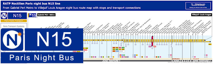
Paris Noctilien night bus N15 map with stops and transport connections
There are several Noctilien night bus stops on the N15 bus line that are within easy walking distance of Grand Rex, however, the most practical and convenient option is the Reaumur - Montmartre stop, because as you can see from the Noctilien N15 maps and timetables, this can be utilised for travelling in either direction going towards Gabriel Peri - Metro or to Villejuif - Louis Aragon, whereas some others such as Bourse are located on a one way street and only go to one particular terminus.
Paris night bus line N15 stops:
Gabriel Peri - Metro, Place Voltaire, Leon Blum, Landy - Martre*, Mairie de Clichy, Jaures - Barbusse**, Barbusse - Martre*, Victor Hugo - Jean Jaures**, Victor Hugo - 8 Mai 1945*, Porte de Clichy, Boulay, Brochant - Cardinet, Rue des Moines*, Legendre, La Fourche, Ganneron, Place de Clichy, Bucarest, Europe, Gare Saint-Lazare - Rome**, Gare Saint-Lazare, Rome - Haussmann*, Auber, Opera, Opera - 4 Septembre**, Choiseul*, Richelieu - 4 Septembre**, Richelieu - Drouot*, Bourse**, Grands Boulevards*, Reaumur - Montmartre, Louvre - Etienne Marcel, Bourse de Commerce, Louvre - Rivoli, Pont Neuf - Quai du Louvre**, Rivoli - Pont Neuf*, Chatelet - Quai des Gesvres**, Chatelet*, Cite - Parvis Notre-Dame**, Cite - Palais de Justice*, Petit Pont**, Notre-Dame - Quai de Montebello*, Dante**, Lagrange*, Maubert - Mutualite, Cardinal Lemoine, Monge, Censier - Daubenton, Monge - Claude Bernard, Les Gobelins, Banquier, Place d'Italie - Mairie du 13eme, Place d'Italie - Italie 2, Vandrezanne, Italie - Tolbiac, Maison Blanche, Porte d'Italie, Porte d'Italie - Helene Boucher, Roger Salengro - Fontainebleau, Convention - Fontainebleau, Le Kremlin-Bicetre Metro, Dauphin - Anatole France, Henri Barbusse, Dispensaire Danielle Casanova, Jean Jaures**, Paul Vaillant-Couturier - Hopital Paul Brousse*, Guynemer - Place des Fusilles**, Guynemer - Maxime Gorki, Guynemer - Place des Fusilles*, Villejuif - Louis Aragon.
* Stop served in the direction of Gabriel Peri - Metro. ** Stop served in the direction of Villejuif - Louis Aragon.
Paris night bus line N15 main transport connections:
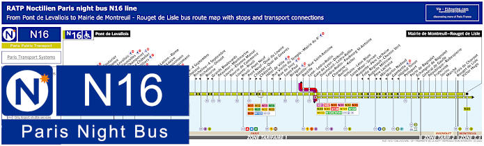
Paris Noctilien night bus N16 map with stops and transport connections
However, the Noctilien N16 night bus line travels from Pont de Levallois to Mairie de Montreuil - Rouget de Lisle and for getting to or from the Grand Rex, just like the route above, the Reaumur - Montmartre stop is the most convenient option, yet this night bus also has stops close to many other tourist attractions including the Louvre - Rivoli for getting to the Louvre museum.
Paris night bus line N16 stops:
Pont de Levallois, Picasso*, Vaillant - Couturier*, Anatole France**, Mairie de Levallois*, Porte de Courcelles*, Porte de Champerret, Pereire - Le Chatelier*, Pereire - Villiers**, Europe, Gare Saint-Lazare - Rome**, Gare Saint-Lazare, Rome - Haussmann*, Havre - Haussmann**, Auber, Opera, Opera - 4 Septembre**, Choiseul*, Richelieu - 4 Septembre**, Richelieu - Drouot*, Bourse**, Grands Boulevards*, Reaumur - Montmartre, Louvre - Etienne Marcel, Bourse de Commerce, Louvre - Rivoli, Rivoli - Pont Neuf*, Pont Neuf - Quai du Louvre**, Chatelet - Quai de Gesvres**, Chatelet*, Hotel de Ville, Rue Vieille du Temple - Mairie du 4e*, Rue de Jouy**, Saint-Paul, Birague, Bastille - Rue Saint-Antoine, Bastille, Lyon - Ledru-Rollin, Gare de Lyon - Diderot, Daumesnil - Ledru-Rollin, Ledru-Rollin - Faubourg St-Antoine, Charonne - Keller, Basfroi, Voltaire - Leon Blum, Saint-Maur - Servan, Roquette - Pere Lachaise, Folie Regnault - Chemin Vert*, Auguste Metivier*, Pere Lachaise**, Muriers*, Martin Nadaud*, Gambetta*, Hopital Tenon*, Pelleport, Porte de Bagnolet, Echangeur de Bagnolet**, General de Gaulle, Republique - Robespierre, Fraternite, Sorins, Marche, Croix de Chavaux - Rouget de Lisle, Victor Hugo, Mairie de Montreuil - Rouget de Lisle.
* Served in direction of Pont de Levallois. ** Served in direction of Mairie de Montreuil - Rouget de Lisle.
Paris night bus line N16 main transport connections:
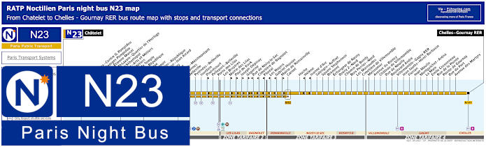
Paris Noctilien night bus N23 map with stops and transport connections
Yet travelling from central Paris at Chatelet, the Noctilien N23 night bus route goes through different ticket tariff zones within the Paris region of Ile de France to a terminus at Chelles - Gournay RER, and as you will see from the night bus maps and timetables, you would need either the Arts et Metiers or the Reaumur - Arts et Metiers stop depending upon your direction of travel.
Paris night bus line N23 stops:
Chatelet, Les Halles - Centre Georges Pompidou, Centre Georges Pompidou, Turbigo - Etienne Marcel, Grenier St-Lazare - Quartier d'Horloge, Reaumur-Sebastepol, Reaumur - Arts et Metiers, Arts et Metiers, Square du Temple, Turbigo - Republique, Republique, Ferry - Lenoir, Parmentier - Republique, Saint-Maur - Jean Aicard, Jules Ferry, Goncourt, Belleville - Menilmontant, Couronnes, Belleville, Pyrenees - Belleville, Jourdain, Pixerecourt, Pelleport - Belleville, Porte des Lilas, Les Bruyeres, Mairie des Lilas, Paul de Kock, Joseph Depinay, Gagarine, Rue de Noisy-le-Sec, Cimetiere de Bagnolet, Floreal, Les Noyers, Gabriel Husson, Mairie de Romainville, Carnot, Hoche, Helene, Jeanne d'Arc, Salengro - Auffret, Square Stephenson, Brement, Echangeur de Rosny, Rosny 2 - Nord, Chemin de Bondy, Bois - Perrier - Nord, Les Marnaudes, Cimetiere de Villemomble, Meissonier, Avenue du Raincy, Chateau de Villemomble, Rue de Neuilly, Boulevard Andre, Villemomble - Gagny RER, Jean Jaures - Henri Barbusse, Florian, Jean Moulin, Montguichet - Arena, La Mare, Emile Cossonneau, Rue de la Pointe, Pointe de Gournay, Rue du Port, Avenue des Martyrs, Chelles - Gourney RER.
Paris night bus line N23 main transport connections:
Metro Lines: 1, 2, 3, 3bis, 4, 5, 7, 8, 9, 11, 14. Train Lines: A, B, D, E. Tram Line: T3b. Bus Lines: N01, N02, N11, N12, N13, N14, N15, N16, N122, N141, N142.
Paris Open Tour bus sightseeing tour map for Blue, Red and Green bus lines with stops and timetables
Yet for those of you that would like to do some sightseeing while you are in Paris, even if it would be before an event at the Grand Rex, then you may be pleased to know that there is a sight-seeing tour bus company called Open Tour. They offer a hop on and hop off bus tour service with 3 different routes covering well over 40 stops by Paris tourist attractions and as you will see from the Open Tour maps and information, the closest stop to Grand Rex is on the Red tour line as Stop 36 called Bonne Nouvelle - Grand Rex, which is located at 36 Boulevard de Bonne-Nouvelle, 75010.
1: Haussmann - Opera - Visitor centre - 13 Rue Auber, 75009 30: Trinite - 32 Rue Mogador, 75009 31: Moulin Rouge - Pigalle - 59 Boulevard de Clichy, 75009 32: Montmartre - Sacre-Coeur - 68 Boulevard de Rochechouart, 75018 33: Gare du Nord - 21 Rue de Dunkerque, 75010 34: Gare de l'Est - 129 Rue du Faubourg St-Martin, 75010 35: Republique - Face au 11 Boulevard Saint-Martin, 75003 36: Bonne Nouvelle - Grand Rex - 36 Boulevard de Bonne-Nouvelle, 75010 37: Grands Boulevards - Hard Rock Cafe - 16 Boulevard Montmartre, 75009
Paris Open Tour bus sightseeing tour maps with stops and timetables:
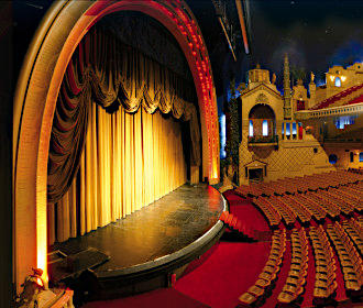
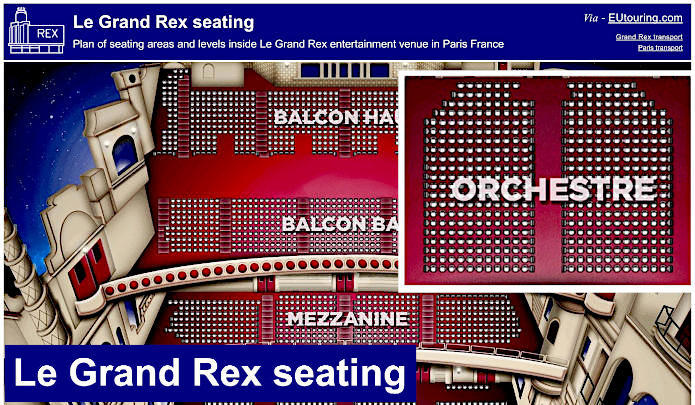
So here you can see Le Grand Rex seating plan with its top and lower balconies, the mezzanine level and the main part of the Grand Rex concert hall classed as the Orchestra area right in front of the stage within the historical building that is not just a cinema, but also a venue for shows and concerts within the Great Hall that you can see the layout of here.