RATP bus maps and timetables for Paris bus lines 560 through to 569


Below are the timetables, route maps showing bus stops, transport connections and street plans for Paris bus lines 560 through to 569, which are available in PDF and image file formats, as well as in large or small file sizes, making these ideal for download to any home PC or mobile device.

Paris bus maps - Central Bus Lines  01-09  10-19  20-29  30-39  40-49  50-59  60-69  70-79  80-89  90-99  100-109  110-119  120-129  130-139  140-149  150-159  160-169  170-179  180-189  190-199  200-209  210-219  220-229  230-239  240-249  250-259  260-269  270-279  280-289  290-299  300-309  310-319  320-329  330-339  340-349  350-359  360-369  370-379  380-389  390-399  400-409  420-429  430-439  440-449  450-459  460-469  470-479  480-489  490-499  500-509  510-519  520-529  530-539  540-549  550-559  560-569  570-579  580-589  590-599  610-619  620-629  700-709  Abeilles Buses  Batobus  Big Bus  DM Buses  Express A14  Fileo Buses CDG1  GO C Orly Shuttle Bus  Le Bus Direct  Magical Shuttle  OrlyBus  R4 Bus  RoissyBus  T'Bus CDG1  TICE Buses  Tootbus  TVM Bus  TZen Buses  Versailles Express  Vitavil  -  Noctilien Night Buses

RATP Paris V4 bus line 562 with stops, connections and street plan

Paris v4 Valouette bus 562 map with stops and connections
Now this map shows the Paris Bus route for the RATP line 562, which is also called the V4, V4 Valouette and line 562, and this goes in a complete circuit from Hotel de Ville - Centre with many additional bus stops on route like Vache Noire - Centre Commercial, Arcuil - Cachan RER, Maison des Gardes, Maison du Grand Cedre, Colonel Fabien and Quatre Chemins, plus several others.

Paris bus line 562 stops:


Hotel de Ville - Centre, Maison du Grand Cedre, Colonel Fabien, Quatre Chemins - Pauline Kergomard, Ricardo - Le Plateau, Ricardo, Quatre Chemins, Hotel de Ville d'Arcueil* **, Henri Barbusse, Maison des Gardes, Bibliotheque, La Poste, Emile Raspail**, Arcueil - Cachan RER, Parc Paul Vaillaint Couturier, Croix d'Arcueil, Vache Noire**, Centre de Sante - Place M. Cachan, Chaperon vert, Benoit Malon.

* Stop only served in one direction.
** Stop not accessible to those with reduced mobility.

Paris bus line 562 main transport connections:


Train Line: B.
Bus Lines: 57, 186, 187, 188, 197, 323, 380, 580, v5 (584).

Paris bus 562 route maps available:


RATP V4 Bus Line 562 map - PDF (standard quality - 0.690 MB)
RATP V4 Bus Line 562 map - PDF (high quality - 2.392 MB)
RATP V4 Bus Line 562 map - Image (standard quality - 0.694 MB)
RATP V4 Bus Line 562 map - Image (high quality - 1.470 MB)

Paris bus 562 timetables:


RATP V4 Bus 562 timetables - PDF (0.983 MB)
RATP V4 Bus 562 timetables - Image (2.932 MB)

RATP Paris bus line 563 with stops, connections and street plan

Paris bus 563 not running replace by Bus 263

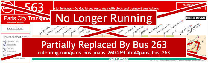
Paris bus 563 now partially replaced by Bus 263


Information below held for historical and archiving purposes


Whereas this map shows the Paris Bus route for the RATP line 563 that travels between Nanterre - Place de la Boule - Gambetta and Suresnes - De Gaulle, which has 20 different bus stops including the Ecole Jules Ferry, Docteur Charcot, Fabre d'Eglantine, Les Godardes, La Chapelle, Place du 8 Mai 1945, Avenue des Landes, Hopital Foch, Gare de Suresnes - Mont Valerien, etc.

Paris bus line 563 stops:


Nanterre - Place de la Boule - Gambetta, Les Ombraies**, Ecole Jules Ferry*, Docteur Charcot, Les Gibets, Danton - Gambetta, Fabre d'Eglantine, Voltaire, Le Brix, Les Godardes, La Paix, Racine, La Chapelle, Place du 8 Mai 1945, Buffon, Mont Valerian*, Avenue des Landes, Cluseret - Hopital Foch, Worth**, Hopital Foch**, Gare de Suresnes Mont Valerien*, Suresnes - De Gaulle.

* Served in direction of Nanterre - Place de la Boule - Gambetta.
** Served in direction of Suresnes - De Gaulle.

Paris bus line 563 main transport connections:


Bus Lines: 93, 141, 144, 158, 160, 163, 241, 244, 258, 304, 360*, 559, 560, AS Suresnes (544).

* Only in the direction of Suresnes de Gaulle

Paris bus 563 route maps available:


RATP Bus Line 563 map - PDF (standard quality - 0.441 MB)
RATP Bus Line 563 map - PDF (high quality - 1.058 MB)
RATP Bus Line 563 map - Image (standard quality - 0.514 MB)
RATP Bus Line 563 map - Image (high quality - 0.843 MB)

Paris bus 563 timetables:


RATP Bus 563 timetables - PDF (1.787 MB)
RATP Bus 563 timetables - Image (1.578 MB)
Paris RATP bus Brioche Doree Boulevard Saint-Michel

RATP Paris Rueil Malmaison bus line 564 with stops, connections and street plan

Paris Rueil Malmaison bus 564 map with stops and connections
And this map shows the Paris Bus route for the RATP line 564, also called the Rueil Malmaison route and Circulaire College La Malmaison, that runs Monday to Friday and does a complete circuit from the College La Malmaison with ten additional bus stops, which are Les Pince-Vins, Bergerie, Bois Saint-Pere, Bretagne, Tuck Stell close to the Chateau de Vers-Mont, Place Osiris, Bois Preau, George Sand, Place Richelieu and the Eglise de Rueil.

Paris bus line 564 stops:


College La Malmaison, Place Osiris, Bois Preau, Eglise de Rueil, Place Richelieu, Goerge Sand, Tuck Stell, Bretagne, Bois Saint-Pere, Bergerie, Les Pince-Vins.

Paris bus 564 route maps available:


RATP Rueil Malmaison Bus Line 564 map - PDF (standard quality - 0.370 MB)
RATP Rueil Malmaison Bus Line 564 map - PDF (high quality - 1.131 MB)
RATP Rueil Malmaison Bus Line 564 map - Image (standard quality - 0.387 MB)
RATP Rueil Malmaison Bus Line 564 map - Image (high quality - 0.827 MB)

Paris bus 564 timetables:


RATP Rueil Malmaison Bus 564 timetables - PDF (0.494 MB)
RATP Rueil Malmaison Bus 564 timetables - Image (1.442 MB)

RATP Paris Rueil Malmaison bus line 565 with stops, connections and street plan

Paris Rueil Malmaison bus 565 map with stops and connections
Yet this map shows the Paris Bus route for the RATP line 565, also known as Rueil Malmaison, that travels between the Mairie de Rueil and Hauts de Rueil - Eglise de Buzenval, with a different route depending on your direction and runs from Monday to Saturday, but not on Sundays or holidays. This service has bus stops going to places such as the Eglise de Rueil, Hopital Stell, Place Richelieu, Place Besche by the Parc du Pere Joseph, Fouilleuse by the Stade Maurice Hubert and the Place de Buzenval to name a few.

Paris bus line 565 stops:


Mairie de Rueil*, Eglise de Rueil, Mairie de Rueil, Hopital Stell, Place Richelieu, Zurich, Place Besche, Fond Louvet, Primeveres**, 19 Janvier**, Fouilleuse, Dumouriez, Henri Regnault, Place de Buzenval, Hauts de Rueil (Eglise de Buzenval)*.

* Start / Terminus points.
** Stop not accessible to those with reduced mobility.

Paris bus line 565 main transport connections:


Bus Lines: 141, 144, 241, 459, 467.

Paris bus 565 route maps available:


RATP Rueil Malmaison Bus Line 565 map - PDF (standard quality - 0.396 MB)
RATP Rueil Malmaison Bus Line 565 map - PDF (high quality - 1.232 MB)
RATP Rueil Malmaison Bus Line 565 map - Image (standard quality - 0.399 MB)
RATP Rueil Malmaison Bus Line 565 map - Image (high quality - 0.869 MB)

Paris bus 565 timetables:


RATP Rueil Malmaison Bus 565 timetables - PDF (0.465 MB)
RATP Rueil Malmaison Bus 565 timetables - Image (1.375 MB)
Paris Open Tour buses Notre Dame Cathedral

RATP Paris bus line 566 with stops, connections and street plan

Paris bus 566 map with stops and connections
But this map shows the Paris Bus route for the RATP line 566, also referred to as Line Colomb and Lines Colombes, that travels from Eglise de Colombes to Rue de l'Industrie, with additional bus stops on route including Marie de Colombes, Rue de la Station, Litolff, Les Vallees, plus a few others.

Paris bus line 566 stops:


Eglise de Colombes, Mairie de Colombes, Rhin et Danube, Julien Galle, Rue de la Station**, Marechal Joffre*, Litolff, Monts Clairs*, Les Vallees, Felix Faure, Varsovie**, Jean Wiener*, Rue de l'Industrie.

* Stop served in direction of Eglise de Colombes.
** Stop served in direction of Rue de l'Industrie.

Paris bus line 566 main transport connections:


Bus Lines: 164, 167, 176, 276, 304, 366, 378.

Paris bus 566 route maps available:


RATP Bus Line 566 map - PDF (standard quality - 0.400 MB)
RATP Bus Line 566 map - PDF (high quality - 1.312 MB)
RATP Bus Line 566 map - Image (standard quality - 0.422 MB)
RATP Bus Line 566 map - Image (high quality - 0.908 MB)

Paris bus 566 timetables:


RATP Bus 566 timetables - PDF (0.493 MB)
RATP Bus 566 timetables - Image (1.393 MB)

RATP Paris Tim bus line 569 with stops, connections and street plan

Paris TIM bus 569 map with stops and connections
However, the last map for this section shows the Paris Bus route for the RATP line 569 also known as the TIM line serving the Meudon area and this travels in a complete circuit from the Gare de Bellevue with many additional bus stops to places such as Eglise de Meudon, Lycee Rabelais, Meudon Val Fleury RER, Maison Rouge - Rue de Paris, Gare de Meudon, College Bel Air, Carrefour de la Ferme, etc.

Paris bus line 569 stops:


Gare de Bellevue, Gardes - Bel Air, Hameau, Tour, 11 Novembre, Verrerie*, Avant-Seine*, Gardes Vaugirard*, Meudon-sur-Seine Tramway, Parc Gauer*, Berthelot - Marcel Bec*, Observatoire*, Terre Neuve*, Eglise de Meudon, Victor Hugo - Louvois*, Val Fleury RER*, Larris*, Pere Brottier - Charles Infroit, Galliera St-Philippe*, Rivoli, Petite Fontaine, Borne Sud, Rivoli, Paul Bert.

* Stop not accessible to those with reduced mobility.

Paris bus line 569 main transport connections:


Train Lines: C, N.
Tram Line: T2.
Bus Lines: 162, 169, 289, 389.

Paris bus 569 route maps available:


RATP Tim Bus Line 569 map - PDF (standard quality - 0.537 MB)
RATP Tim Bus Line 569 map - PDF (high quality - 1.802 MB)
RATP Tim Bus Line 569 map - Image (standard quality - 0.528 MB)
RATP Tim Bus Line 569 map - Image (high quality - 1.131 MB)

Paris bus 569 timetables:


RATP Tim Bus 569 timetables - PDF (0.567 MB)
RATP Tim Bus 569 timetables - Image (1.554 MB)